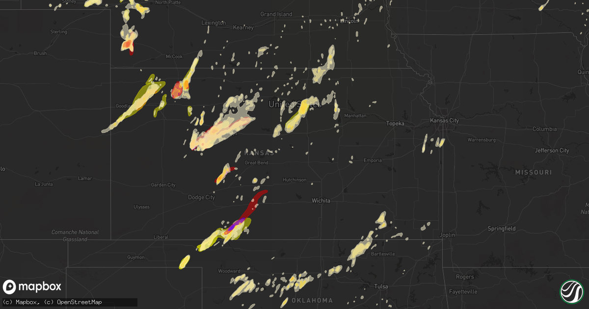
Hail Map in Kansas on May 18, 2013
Get this storm
May 18 map
$229
one time, instant access
Download today. No call, no setup
Keep the $229
Bought the map and want the full workflow? Apply the entire $229 to a subscription within 7 days. None of it is wasted.
Every map, not just this one
This buys you this map. Subscription and you get every map we run, in the markets you choose from a few cities to whole states to nationwide. Plus real-time alerts the moment a storm fires.
Contact data
Name, contact info, occupancy, even credit band for addresses in the footprint. You go from where it hit to who to call.
Become the source they trust
Unlimited branding weather history reports on demand. You already have the documented answer ready for the property owner, and you are the one who showed up with it.
Property data and RoofTrace estimates
Pull up any address you have got, its value and the exact code rules for that jurisdiction, straight from One Click Code. Then RoofTrace estimates the squares, pitch, and roof value, priced the way you price.
Storm reports in Kansas
Kansas
| Date | Description |
|---|---|
| 05/18/20136:45 PM CDT | A local report indicates 1.00 inch wind near 2 NW SANFORD |
| 05/18/20136:45 PM CDT | A local report indicates a tornado near ROZEL |
| 05/18/20136:26 PM CDT | Trained spotter reports quarter size hail and estimated winds of 60 mph. |
| 05/18/20136:25 PM CDT | A local report indicates 2.00 inch wind near 6 S GRAY |
| 05/18/20136:25 PM CDT | A local report indicates a tornado near 2 NW SANFORD |
| 05/18/20136:10 PM CDT | A local report indicates 1.75 inch wind near 6 S OGALLAH |
| 05/18/20136:03 PM CDT | A local report indicates a tornado near 5 S ELLIS |
| 05/18/20136:03 PM CDT | A brief multi-vortex tornado was observered. The tornado lasted 1 to 2 minutes. |
| 05/18/20136:00 PM CDT | A local report indicates 1.75 inch wind near 3 W BROWNELL |
| 05/18/20135:50 PM CDT | A local report indicates 2.00 inch wind near 3 SE RANSOM |
| 05/18/20135:45 PM CDT | The hail was measured 30 minutes after it fell. |
| 05/18/20135:34 PM CDT | Estimated quarter size hail in selden. |
| 05/18/20135:30 PM CDT | A local report indicates 1.00 inch wind near 8 S TREGO CENTER |
| 05/18/20135:26 PM CDT | A local report indicates 1.25 inch wind near SELDEN |
| 05/18/20135:05 PM CDT | A local report indicates 1.75 inch wind near 5 ENE ARNOLD |
| 05/18/20134:45 PM CDT | A local report indicates 1.75 inch wind near RANSOM |
| 05/18/20134:40 PM CDT | Quarter sized hail about 5 miles w of atwood. |
| 05/18/20134:40 PM CDT | Found quarter sized hail in a ditch at intersection of us highway 24 and us 83. |
| 05/18/20134:26 PM CDT | The caller reported hail as bigger than golfball. |
| 05/18/20134:25 PM CDT | A local report indicates 1.00 inch wind near UTICA |
| 05/18/20134:17 PM CDT | Report of quarter sized hail near mile marker 61. Report verified by sheriff dispatch in thomas county. |
| 05/18/20134:13 PM CDT | A local report indicates 1.75 inch wind near 4 SW UTICA |
| 05/18/20134:00 PM CDT | A local report indicates 1.75 inch wind near 7 W WAKEENEY |
| 05/18/20135:46 AM CDT | A local report indicates 60 MPH wind near 10 N LEVANT |
| 05/18/20135:46 AM CDT | A local report indicates 1.00 inch wind near 10 N LEVANT |
| 05/18/201312:10 AM CDT | 24 inch diameter tree blown over and several branches damaged. |
| 05/18/201312:00 AM CDT | 6 to 7 inch diameter tree branches down |
| 05/17/201311:55 PM CDT | 6 to 7 inch diameter tree branches down |
| 05/17/201311:55 PM CDT | Tree branches and power lines down at 17th and washburn |
| 05/17/201311:54 PM CDT | Power line down at 2000 block of se iowa avenue |
| 05/17/201311:45 PM CDT | Tree branches down in town |
| 05/17/201311:45 PM CDT | Large tree limb - 6 inches in diameter - down at 7200 block of of sw 10th street. |
| 05/17/201311:44 PM CDT | Estimated |
| 05/17/201311:31 PM CDT | A local report indicates 60 MPH wind near 5 NNE VERMILLION |
| 05/17/201311:30 PM CDT | A local report indicates 60 MPH wind near 4 SSW CORNING |
| 05/17/201311:22 PM CDT | Tree down in road. |
| 05/17/201311:15 PM CDT | Tree limbs down |
| 05/17/201311:07 PM CDT | Reports of power lines down |
| 05/17/201311:03 PM CDT | Three trailers flipped over. 6 inch limb through the side of a house. |
| 05/17/201311:03 PM CDT | Large barn and numerous outbuildings destroyed. |
| 05/17/201311:00 PM CDT | Ef0 tornado touched down on southwest side of washington. |
| 05/17/201311:00 PM CDT | Structural damage to buildings in town |
| 05/17/201310:59 PM CDT | Reports of building damage at an industrial park on the west side of town. |
| 05/17/201310:57 PM CDT | Penny size hail with the winds. |
| 05/17/201310:51 PM CDT | Power out on fort riley. Large trees down in junction city. |
| 05/17/201310:50 PM CDT | Pea size hail |
| 05/17/201310:50 PM CDT | A local report indicates 60 MPH wind near 2 WNW ST. GEORGE |
| 05/17/201310:48 PM CDT | Machine shed destroyed. |
| 05/17/201310:43 PM CDT | Power out in town due to thunderstorm winds. |
| 05/17/201310:40 PM CDT | Reports of a house heavily damaged |
| 05/17/201310:40 PM CDT | Tree branches down |
| 05/17/201310:35 PM CDT | One camper flipped over with 2 minor injuries and another camper damaged. Areas north and west of junction city without power. |
| 05/17/201310:35 PM CDT | A local report indicates 60 MPH wind near 3 W JUNCTION CITY |
| 05/17/201310:35 PM CDT | Wind gusts estimated 60 to 70 mph. Power lines down in junction city. |
| 05/17/201310:35 PM CDT | Ef1 tornado touched down and traveled to just east of clifton and into extreme southern washington county before dissipating. |
| 05/17/201310:30 PM CDT | One camper flipped over with 2 minor injuries and another camper damaged. Areas north and west of junction city without power. |
| 05/17/201310:20 PM CDT | Wind gusts estimated 60 to 70 mph. Tree linbs down and pea size hail |
| 05/17/201310:10 PM CDT | Roof blown off houses. Trees blown into house. Damage to garages. |
| 05/17/201310:02 PM CDT | A local report indicates 1.00 inch wind near 5 N DELPHOS |
| 05/17/20139:50 PM CDT | A local report indicates 1.75 inch wind near 3 E DELPHOS |
| 05/17/20139:50 PM CDT | Wind gust estimated around 80 mph. Several trees uprooted. Damage to roofs and tree branches in the town of minneaplolis and lidsney. |
| 05/17/20139:05 PM CDT | A local report indicates 90 MPH wind near NICKERSON |
| 05/17/20139:05 PM CDT | Emergency manager reports downed power lines in nickerson. |
| 05/17/20138:52 PM CDT | Emergency manager reported 50 to 60 mph wind gust at abbyville. |
| 05/17/20138:50 PM CDT | A local report indicates 60 MPH wind near 5 SSE PLEVNA |
| 05/17/20137:58 PM CDT | A local report indicates a tornado near 2 NE SANFORD |
| 05/17/20137:45 PM CDT | A local report indicates a tornado near ROZEL |
| 05/17/20137:45 PM CDT | A local report indicates a tornado near 1 WSW ROZEL |
| 05/17/20137:40 PM CDT | The dispatch said there were numerous reports from around the county of heavy rain and nickel to quarter size hail. |
| 05/17/20137:34 PM CDT | A local report indicates 1.00 inch wind near 4 SSE WILMORE |
| 05/17/20137:32 PM CDT | Law enforcement reported dime to quarter sized hail. Time is approximated with radar. |
| 05/17/20137:31 PM CDT | This tornado was reported as a large stovepipe tornado. |
| 05/17/20137:27 PM CDT | A local report indicates 1.00 inch wind near ROZEL |
| 05/17/20137:27 PM CDT | A local report indicates a tornado near 2 ESE ROZEL |
| 05/17/20137:27 PM CDT | A local report indicates a tornado near 7 N GARFIELD |
| 05/17/20137:25 PM CDT | A local report indicates a tornado near 2 NW SANFORD |
| 05/17/20137:25 PM CDT | A local report indicates a tornado near 5 SE BURDETT |
| 05/17/20137:24 PM CDT | A local report indicates a tornado near 5 SSW ROZEL |
| 05/17/20137:22 PM CDT | A local report indicates a tornado near 1 SSW ROZEL |
| 05/17/20137:21 PM CDT | A local report indicates a tornado near 5 E BURDETT |
| 05/17/20137:12 PM CDT | A local report indicates 1.25 inch wind near CATHERINE |
| 05/17/20137:10 PM CDT | A local report indicates 1.00 inch wind near CATHERINE |
All States Impacted by Hail Map on May 18, 2013
Cities Impacted by Hail Map on May 18, 2013
- Ogema, MN
- Garner, IA
- Lewellen, NE
- White Lake, SD
- Hay Springs, NE
- Rapid City, SD
- Keswick, IA
- Barnes City, IA
- What Cheer, IA
- Gibson, IA
- Deep River, IA
- The Villages, FL
- Summerfield, FL
- Belleview, FL
- Oxford, FL
- Boys Town, NE
- Omaha, NE
- Bennington, NE
- Bethune, CO
- Burlington, CO
- Sharon, OK
- Osborne, KS
- Booker, TX
- Quanah, TX
- Crowell, TX
- Plainville, KS
- Eagle Butte, SD
- Dupree, SD
- Fort Pierre, SD
- Vinson, OK
- Hollis, OK
- Gould, OK
- Kadoka, SD
- Sayre, OK
- Elk City, OK
- Faith, SD
- Faxon, OK
- Wildwood, FL
- Upton, WY
- Danube, MN
- Waukomis, OK
- Hennessey, OK
- Rolfe, IA
- Long Island, KS
- Phillipsburg, KS
- Atkinson, NE
- Colby, KS
- Gem, KS
- Hemingford, NE
- Greenleaf, KS
- Selden, KS
- Geronimo, OK
- Lawton, OK
- Crawford, NE
- Harrison, NE
- Marsland, NE
- Newell, SD
- Vale, SD
- Sturgis, SD
- Bishopville, SC
- Ogallah, KS
- Wakeeney, KS
- Ellis, KS
- Dickinson, ND
- Clara City, MN
- Nashua, IA
- Rushville, NE
- Cleveland, ND
- Medina, ND
- Jamestown, ND
- Webster, IA
- Delta, IA
- Sigourney, IA
- Neligh, NE
- Tilden, NE
- Plainview, NE
- Lorraine, KS
- Philip, SD
- Morland, KS
- Collyer, KS
- Hill City, KS
- Omega, OK
- Kingfisher, OK
- Ransom, KS
- Utica, KS
- Clearwater, NE
- Altus, OK
- Clay Center, KS
- Munday, TX
- Weinert, TX
- Goree, TX
- Sedan, KS
- Bridgeport, NE
- Brule, NE
- Chappell, NE
- Oshkosh, NE
- Big Springs, NE
- Ogallala, NE
- Mangum, OK
- Duke, OK
- Childress, TX
- Raleigh, ND
- Shields, ND
- Carson, ND
- Marshall, OK
- Bison, OK
- Douglas, OK
- Guernsey, IA
- Victor, IA
- Dighton, KS
- Quinter, KS
- Enid, OK
- Broadwater, NE
- Edgerton, KS
- Kyle, SD
- Scenic, SD
- Alliance, NE
- Paxton, NE
- Elk City, KS
- Hays, KS
- Kinsley, KS
- Larned, KS
- Spearville, KS
- Rozel, KS
- Hanston, KS
- Burdett, KS
- Elgin, ND
- Buffalo, OK
- Deadwood, SD
- Nemo, SD
- Beloit, KS
- Glasco, KS
- Simpson, KS
- Chandler, MN
- Arapaho, OK
- Chillicothe, TX
- Ponsford, MN
- Cyril, OK
- Mountain View, OK
- Fletcher, OK
- Gotebo, OK
- Mountain Park, OK
- Elgin, OK
- Headrick, OK
- Carnegie, OK
- Hobart, OK
- Altus Afb, OK
- Apache, OK
- Indiahoma, OK
- Roosevelt, OK
- Blair, OK
- Lone Wolf, OK
- Gettysburg, SD
- Amelia, NE
- Barnard, KS
- Lincoln, KS
- Grant, NE
- Fairbury, NE
- Endicott, NE
- Elsmere, NE
- Chambers, NE
- Dix, NE
- Interior, SD
- Wall, SD
- Lincoln, NE
- Dacula, GA
- Buford, GA
- Lawrenceville, GA
- Cumming, GA
- Suwanee, GA
- Flowery Branch, GA
- Stuart, NE
- Platte, SD
- Cordell, OK
- Delphos, KS
- Putnam, OK
- Custer City, OK
- Taloga, OK
- Waldo, KS
- Lusk, WY
- Belle Fourche, SD
- Spearfish, SD
- Dill City, OK
- Sentinel, OK
- Republican City, NE
- Naponee, NE
- Covington, OK
- Drummond, OK
- Fairmont, OK
- Brooklyn, IA
- Montezuma, IA
- Jay Em, WY
- Milford, NE
- Dorchester, NE
- Gillette, WY
- Carthage, TN
- Elmwood, TN
- Corn, OK
- Woonsocket, SD
- Welch, OK
- Fairview, OK
- Macksville, KS
- St John, KS
- Atwood, KS
- New Ulm, MN
- Brownell, KS
- Chester, OK
- Seiling, OK
- Minco, OK
- Akron, CO
- Otis, CO
- Lindon, CO
- Oberlin, KS
- Elsie, NE
- Cherry Creek, SD
- Union City, OK
- Tuttle, ND
- Steele, ND
- Linton, ND
- Upland, NE
- Franklin, NE
- Hildreth, NE
- Wilmore, KS
- Coldwater, KS
- Eldorado, OK
- Tryon, NE
- Park, KS
- Cleveland, MO
- Bucyrus, KS
- Belton, MO
- Louisburg, KS
- Beverly, KS
- Concordia, KS
- Clyde, KS
- Aurora, KS
- Minneapolis, KS
- Tescott, KS
- Miltonvale, KS
- Gayville, SD
- Mission Hill, SD
- Pawhuska, OK
- Tuttle, OK
- Mustang, OK
- Newton, IA
- Sioux Rapids, IA
- Linn Grove, IA
- Pine Ridge, SD
- Mutual, OK
- Vici, OK
- Leedey, OK
- Mooreland, OK
- Camargo, OK
- Lisco, NE
- New Leipzig, ND
- Havelock, IA
- Mallard, IA
- Lebanon, TN
- Wilsonville, NE
- Edson, KS
- Levant, KS
- Brewster, KS
- Sharon Springs, KS
- Weskan, KS
- Arapahoe, CO
- Goodland, KS
- McDonald, KS
- Bancroft, IA
- Burt, IA
- Watertown, TN
- Kirksville, MO
- Iona, MN
- Georgiana, AL
- Hayes, SD
- Midland, SD
- Keota, IA
- Wellman, IA
- La Grange, NC
- Seven Springs, NC
- Mound City, SD
- Wakpala, SD
- Glencross, SD
- Timber Lake, SD
- Mobridge, SD
- Trail City, SD
- Imperial, NE
- Piedmont, SD
- Burr Oak, KS
- Esbon, KS
- Mellette, SD
- Inland, NE
- Ralston, OK
- Pawnee, OK
- Holyrood, KS
- Bushton, KS
- Claflin, KS
- Copan, OK
- Murdock, MN
- Sacred Heart, MN
- Raymond, MN
- Maynard, MN
- Protection, KS
- Bayard, NE
- Munden, KS
- Haddam, KS
- Belleville, KS
- Morrowville, KS
- Cuba, KS
- Narka, KS
- Mahaska, KS
- Willow, OK
- Guyton, GA
- Granite, OK
- Turon, KS
- Pratt, KS
- Gordon, NE
- Ninnekah, OK
- Emmetsburg, IA
- West Bend, IA
- Monroe, IA
- Otley, IA
- Reasnor, IA
- Pella, IA
- Wilber, NE
- Pleasant Hill, MO
- Lemoyne, NE
- Artesian, SD
- Clark, SD
- Blairsburg, IA
- Burbank, OK
- Shidler, OK
- Isabella, OK
- Norcatur, KS
- South English, IA
- Harper, IA
- Allen, SD
- Hampton, FL
- Gainesville, FL
- Brooker, FL
- Yuma, CO
- Harrison, SD
- Corsica, SD
- York, NE
- Beaver Crossing, NE
- Pierce, NE
- Fosston, MN
- Seminole, OK
- New London, IA
- Mount Pleasant, IA
- Merriman, NE
- Oswego, KS
- Columbus, KS
- Fairfax, OK
- Stapleton, NE
- New Raymer, CO
- Robinson, ND
- Gove, KS
- Herreid, SD
- Lead, SD
- Medicine Park, OK
- Hubbard, IA
- Champion, NE
- Meno, OK
- Black Hawk, SD
- Porcupine, SD
- Woodward, OK
- George, IA
- Ogden, IA
- Boxholm, IA
- Ashland, NE
- Alexander City, AL
- Marengo, IA
- Ladora, IA
- Williamsburg, IA
- Correll, MN
- Wakefield, KS
- Green, KS
- Meeker, OK
- Alton, KS
- Arthur, NE
- Kaycee, WY
- Clemons, IA
- Zearing, IA
- New Providence, IA
- Saint Anthony, IA
- Hitchcock, SD
- Faulkton, SD
- Seward, NE
- Fredonia, KS
- Longton, KS
- Seibert, CO
- Clinton, OK
- Weatherford, OK
- Rosston, OK
- Gate, OK
- Hettinger, ND
- Stockton, KS
- Woodston, KS
- Lebanon, KS
- Cylinder, IA
- Assaria, KS
- Isabel, SD
- Holstein, NE
- Bladen, NE
- Riverton, NE
- Campbell, NE
- Ness City, KS
- Norton, KS
- Washington, KS
- Blue Springs, MO
- Buckner, MO
- Independence, MO
- Grinnell, IA
- Gilman, IA
- Franklin, KY
- Tuskegee, AL
- Okeene, OK
- Burke, SD
- Hermitage, TN
- Nashville, TN
- Mount Juliet, TN
- Ekalaka, MT
- Fort Cobb, OK
- Scammon, KS
- McCune, KS
- West Mineral, KS
- Ringwood, OK
- Ames, OK
- Saint James, MN
- Darfur, MN
- Brunswick, NE
- Morrison, OK
- Red Rock, OK
- Perry, OK
- Courtland, KS
- Alexandria, NE
- McLaughlin, SD
- Adolphus, KY
- Scottsville, KY
- Westmoreland, TN
- Portland, TN
- Victoria, KS
- Catharine, KS
- Bloomingdale, GA
- Ellabell, GA
- Pierre, SD
- Strong City, KS
- Jennings, KS
- Wood Lake, NE
- Anadarko, OK
- Pocasset, OK
- El Reno, OK
- Paradise, KS
- Gorham, KS
- Natoma, KS
- Madison, MN
- Logan, KS
- Naper, NE
- Vivian, SD
- Garrison, IA
- Dysart, IA
- Le Center, MN
- Le Sueur, MN
- Ruthton, MN
- Walters, OK
- Pettibone, ND
- Woodworth, ND
- Tappen, ND
- Dawson, ND
- Presho, SD
- Throckmorton, TX
- Seymour, TX
- Webster City, IA
- Dows, IA
- Williams, IA
- Sylvania, GA
- Mount Union, IA
- Hayesville, IA
- Elmer, OK
- Tipton, OK
- Snyder, OK
- Draper, SD
- Ellsworth, IA
- Wolsey, SD
- Plymouth, NE
- Western, NE
- Jansen, NE
- Swanton, NE
- Marquette, KS
- Yukon, OK
- Marland, OK
- Springfield, GA
- Wallace, NE
- Wanblee, SD
- Ashland, KS
- Selma, AL
- Sterling, CO
- Merino, CO
- Driscoll, ND
- Wellsville, KS
- Rantoul, KS
- Paola, KS
- Solen, ND
- Vinton, IA
- Mount Auburn, IA
- Liscomb, IA
- Elkhorn, NE
- Dawson, MN
- Raymond, SD
- Odell, TX
- Vernon, TX
- Purdum, NE
- Springfield, TN
- Adams, TN
- Cedar Hill, TN
- Hitchcock, OK
- Garden City, SD
- Walcott, ND
- Keystone, NE
- Chaska, MN
- Wood, SD
- Balko, OK
- Laverne, OK
- Beaver, OK
- Gaylord, KS
- Portis, KS
- Inavale, NE
- Sidney, NE
- Arnold, NE
- Tuskegee Institute, AL
- Chickasha, OK
- Verden, OK
- Hoisington, KS
- Otis, KS
- Bagley, MN
- Waverly, NE
- Benkelman, NE
- Hill City, SD
- Junction City, KS
- Chapman, KS
- Danville, IA
- Middletown, IA
- Friend, NE
- Cordova, NE
- Noble, OK
- Norman, OK
- Vona, CO
- Stratton, CO
- Blanchard, OK
- Cedar Rapids, NE
- Foss, OK
- Butler, OK
- Paducah, TX
- Mankato, KS
- Lame Deer, MT
- Howard, SD
- Flagler, CO
- Iliff, CO
- Radcliffe, IA
- Crofton, NE
- Duncan, OK
- Plover, IA
- Riley, KS
- Nicollet, MN
- Letcher, SD
- Ithaca, NE
- Greenwood, NE
- Kellogg, IA
- Chadron, NE
- Sutherland, NE
- Glen Elder, KS
- Mountain Lake, MN
- Watonga, OK
- Dresden, KS
- Hollenberg, KS
- Reynolds, NE
- Hubbell, NE
- Daykin, NE
- De Witt, NE
- Agenda, KS
- Orchard, IA
- Stamford, NE
- Butterfield, MN
- Sleepy Eye, MN
- Hershey, NE
- Independence, KS
- Keystone, IA
- Van Horne, IA
- Kilgore, NE
- Enders, NE
- Keystone, SD
- Sylvan Grove, KS
- Butte, NE
- Astor, FL
- Fort McCoy, FL
- Kit Carson, CO
- Hermosa, SD
- Okaton, SD
- Flomot, TX
- Matador, TX
- Springfield, SD
- Watertown, SD
- Maud, OK
- Parks, NE
- Oakdale, NE
- Scandia, KS
- Burwell, NE
- Hedley, TX
- Gretna, NE
- Pleasantville, IA
- Swan, IA
- Knoxville, IA
- Sully, IA
- Hoxie, KS
- Alden, IA
- Binger, OK
- Leonardville, KS
- Frankfort, SD
- Wilson, KS
- Walton, NE
- Doland, SD
- Ottumwa, IA
- Peetz, CO
- Padroni, CO
- Hartington, NE
- Fordyce, NE
- Saint Helena, NE
- Wanette, OK
- Coon Rapids, IA
- Bradshaw, NE
- Belpre, KS
- Cologne, MN
- Alma, NE
- Stilwell, KS
- Spring Hill, KS
- Grayson, GA
- Loganville, GA
- Snellville, GA
- Ashton, SD
- Redfield, SD
- Oxford, MS
- Cope, CO
- Albion, NE
- Carpenter, SD
- Hudson, KS
- Lafayette, MN
- Winthrop, MN
- Chestnut Mound, TN
- Wever, IA
- Buchanan, ND
- Streeter, ND
- Litchfield, NE
- Webster, FL
- Center Hill, FL
- Halstead, KS
- Ellsworth, KS
- Republic, KS
- Hardy, NE
- Marysville, KS
- Olivia, MN
- Mullen, NE
- Alexandria, TN
- Huron, SD
- Superior, NE
- McIntosh, SD
- Spring Hill, TN
- Rocky, OK
- Claremore, OK
- Brush Creek, TN
- Gordonsville, TN
- Coffeyville, KS
- Lebanon, NE
- Wetumpka, AL
- Coats, KS
- Kimball, SD
- Bowling Green, KY
- Hector, MN
- Edna, KS
- S Coffeyville, OK
- Peculiar, MO
- Greenwood, MO
- Winger, MN
- Arnold, KS
- Palco, KS
- Chokio, MN
- Clermont, FL
- Groveland, FL
- Palmer, KS
- Morganville, KS
- Clifton, KS
- Gregory, SD
- Holdrege, NE
- Malcolm, NE
- Raymond, NE
- Lakota, IA
- Johnstown, NE
- Onaga, KS
- Olmitz, KS
- Callahan, FL
- Remsen, IA
- Le Mars, IA
- Manning, ND
- Thompson, IA
- Lake Crystal, MN
- Macomb, OK
- Lexington, OK
- Ayr, NE
- Rockwell City, IA
- Lakeside, NE
- Herrick, SD
- Wagner, SD
- Webber, KS
- Wamego, KS
- Blue Hill, NE
- Milford, KS
- Tallassee, AL
- Stroud, OK
- Cushing, OK
- Lawrence, NE
- Pukwana, SD
- Jewell, KS
- Petersburg, NE
- Newcastle, WY
- Waterloo, NE
- Crook, CO
- Port Orange, FL
- Wallace, SD
- Bison, KS
- Rush Center, KS
- Shawnee, OK
- Eustis, FL
- Lake Andes, SD
- Geddes, SD
- Liberty, KS
- Pleasant Dale, NE
- Princeton, MO
- Mounds, OK
- Gibbon, MN
- Haskell, OK
- Okmulgee, OK
- Laurens, IA
- Selfridge, ND
- Appleton, MN
- Choctaw, OK
- Albert City, IA
- Fonda, IA
- Auburn, NE
- Hebron, NE
- Barrett, MN
- Morris, MN
- Kensington, MN
- Hoffman, MN
- Gracemont, OK
- Livermore, IA
- Cement, OK
- Donnellson, IA
- Sac City, IA
- Newell, IA
- Dunning, NE
- Vienna, SD
- Willow Lake, SD
- Marion, KS
- Alberta, MN
- Courtland, MN
- Freedom, OK
- Henderson, NE
- Grafton, NE
- Kingsley, IA
- Leigh, NE
- Stewart, MN
- Quinn, SD
- Plattsmouth, NE
- Gardner, KS
- McKenzie, AL
- Hortense, GA
- Springfield, MN
- Comfrey, MN
- Charter Oak, IA
- Madrid, NE
- Hedrick, IA
- Minneola, KS
- Cheyenne Wells, CO
- Randolph, NE
- Martin, SD
- Cherokee, OK
- Carmen, OK
- Otter, MT
- Bristow, OK
- Glenham, SD
- Cleo Springs, OK
- Braymer, MO
- Hamilton, MO
- Miami, OK
- Bogue, KS
- Ashland, MT
- Crookston, NE
- Pacific Junction, IA
- Glenwood, IA
- Council Bluffs, IA
- Gackle, ND
- Dearing, KS
- Cedar Vale, KS
- Martinsburg, IA
- Gallatin, TN
- Hendersonville, TN
- Mannford, OK
- Winfield, IA
- Anton, CO
- Waldo, FL
- Lake Butler, FL
- Pocahontas, IA
- Guide Rock, NE
- Bixby, OK
- Lake City, KS
- Kirk, CO
- Newcastle, OK
- Hickman, NE
- Bennet, NE
- Panama, NE
- Firth, NE
- Adams, NE
- Swea City, IA
- Ledyard, IA
- Garnett, SC
- Clyo, GA
- Shellsburg, IA
- Angora, NE
- Tecumseh, OK
- Osawatomie, KS
- Lodgepole, NE
- Greensburg, KS
- Corwith, IA
- Oxford, NE
- Stafford, KS
- Ventura, IA
- Prairie View, KS
- Ionia, IA
- Belle Plaine, IA
- Wayland, IA
- Joice, IA
- Luzerne, IA
- Grundy Center, IA
- Brandon, MN
- Farwell, MN
- Harrisonville, MO
- Lees Summit, MO
- Chelsea, OK
- Wauneta, NE
- Glenpool, OK
- Formoso, KS
- Duluth, GA
- Whittemore, IA
- Okarche, OK
- Loyal, OK
- Elmwood, NE
- Palmyra, NE
- Marshalltown, IA
- Cache, OK
- Frederick, OK
- Olustee, OK
- New Sharon, IA
- Rose Hill, IA
- Bonesteel, SD
- Lindsborg, KS
- Mcpherson, KS
- Lemmon, SD
- Elberon, IA
- Vining, IA
- Oklahoma City, OK
- Armstrong, IA
- Palmer, NE
- Elwood, NE
- Arapahoe, NE
- Randall, KS
- Longdale, OK
- Fort Yates, ND
- Unionville, TN
- Chapel Hill, TN
- Giltner, NE
- Harvard, NE
- Fleming, CO
- Ewing, NE
- Paton, IA
- Garfield, KS
- Graettinger, IA
- Ringsted, IA
- Kearney, NE
- Brownton, MN
- Coleridge, NE
- Fort Morgan, CO
- Bartlett, NE
- Lewis, KS
- Elmdale, KS
- West Point, IA
- Holbrook, NE
- Cambridge, NE
- Drumright, OK
- Albion, IA
- Asher, OK
- Haviland, KS
- Brady, NE
- Creighton, NE
- Osmond, NE
- Meadow Grove, NE
- Rembrandt, IA
- Alta, IA
- Olathe, KS
- Estherville, IA
- Depew, OK
- Overton, NE
- Orleans, NE
- Trumbull, NE
- Peru, KS
- Haskell, TX
- Marion, AL
- Marion Junction, AL
- Ringling, OK
- Loco, OK
- Ratliff City, OK
- Joes, CO
- Rexford, KS
- Monument, KS
- Bird City, KS
- Herndon, KS
- Sun City, KS
- Byers, KS
- Iuka, KS
- Prairie, MS
- West Point, MS
- Erick, OK
- Carter, OK
- Union Center, SD
- Whitney, NE
- Lantry, SD
- North Platte, NE


