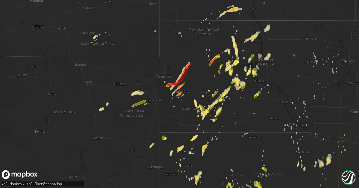
Hail Map on May 18, 2013
Get this storm
May 18 map
$229
one time, instant access
Download today. No call, no setup
Keep the $229
Bought the map and want the full workflow? Apply the entire $229 to a subscription within 7 days. None of it is wasted.
Every map, not just this one
This buys you this map. Subscription and you get every map we run, in the markets you choose from a few cities to whole states to nationwide. Plus real-time alerts the moment a storm fires.
Contact data
Name, contact info, occupancy, even credit band for addresses in the footprint. You go from where it hit to who to call.
Become the source they trust
Unlimited branding weather history reports on demand. You already have the documented answer ready for the property owner, and you are the one who showed up with it.
Property data and RoofTrace estimates
Pull up any address you have got, its value and the exact code rules for that jurisdiction, straight from One Click Code. Then RoofTrace estimates the squares, pitch, and roof value, priced the way you price.
States Impacted by Hail Map on May 18, 2013
Storm reports
Nebraska
| Date | Description |
|---|---|
| 05/18/20136:50 PM CDT | Stones ranged in size from dimes to quarters. Time is estimated by radar. |
| 05/18/20136:50 PM CDT | A local report indicates 2.50 inch wind near 7 S IMPERIAL |
| 05/18/20136:40 PM CDT | A local report indicates 1.75 inch wind near 10 S RUSHVILLE |
| 05/18/20136:30 PM CDT | Stones ranged in size from peas to quarters. |
| 05/18/20136:20 PM CDT | A local report indicates 1.00 inch wind near SIDNEY |
| 05/18/20136:15 PM CDT | A local report indicates 1.00 inch wind near 13 N HAY SPRINGS |
| 05/18/20136:10 PM CDT | Penny to quarter sized hail in sidney. Numerous reports. |
| 05/18/20136:01 PM CDT | A local report indicates a tornado near 9 N BROADWATER |
| 05/18/20135:58 PM CDT | A local report indicates a tornado near 10 N BROADWATER |
| 05/18/20135:34 PM CDT | A local report indicates 1.00 inch wind near 12 NW SIDNEY |
| 05/18/20135:32 PM CDT | Several reports of quarter sized hail in brownson. Relayed via sidney warning point. |
| 05/18/20135:15 PM CDT | Stones ranged everywhere from pea to quarter size. |
| 05/18/20135:15 PM CDT | Report relayed through social media. Time and location estimated based on radar. |
| 05/18/20135:08 PM CDT | Nickel to quarter sized hail. Hail has ended. |
| 05/18/20134:55 PM CDT | A local report indicates 1.00 inch wind near 7 NNE BRULE |
| 05/18/20134:35 PM CDT | Most stones were pea to dime size and were covering the ground. There were a few quarter sized stones. |
| 05/18/201312:00 AM CDT | Tree and swing set damage...delayed report from last night. |
| 05/17/201311:44 PM CDT | Six inch tree limbs downed and nickel-sized hail. 1.65 inches of rain measured. |
| 05/17/201311:40 PM CDT | Roof taken off of a shed along hwy 77. |
| 05/17/201311:33 PM CDT | A local report indicates 1.00 inch wind near JANSEN |
| 05/17/201311:31 PM CDT | A local report indicates 1.00 inch wind near FAIRBURY |
| 05/17/201310:31 PM CDT | Spotty tree damage reported along with some power outages. |
| 05/17/20138:59 PM CDT | Small branches have also been broken. |
| 05/17/20138:35 PM CDT | A local report indicates 1.00 inch wind near 3 E IMPERIAL |
| 05/17/20138:34 PM CDT | Tree is down across game trail road north of hwy 30. |
| 05/17/20138:15 PM CDT | Quarter size hail reported along with winds estimated at 60mph. |
| 05/17/20138:15 PM CDT | Mostly nickel size hail...but some quarter size. |
| 05/17/20137:57 PM CDT | A local report indicates 1.00 inch wind near 2 S KEYSTONE |
| 05/17/20137:49 PM CDT | Power lines were knocked down at county roads 185 and 28. Time is estimated. |
| 05/17/20137:45 PM CDT | Possible tornado damage with report of trees laying on houses and a garage being blown up over 15 to 20 ft trees landing on a neighbors property. |
| 05/17/20137:42 PM CDT | A local report indicates 61 MPH wind near 2 NE NORMAN |
| 05/17/20137:41 PM CDT | Quarter size hail reported 8 miles north and 1 mile west of grant. |
| 05/17/20137:35 PM CDT | Dawson county emergency services. Exact time unkn but estimated from awos. |
| 05/17/20137:29 PM CDT | Quarter size hail reported 3 miles north east of grant. |
| 05/17/20137:17 PM CDT | Hailed for five minutes. |
| 05/17/20137:11 PM CDT | Trees down at the intersection of co rd 207 and hwy 22. |
| 05/17/20137:06 PM CDT | Gust measured on observers davis unit |
| 05/17/20137:04 PM CDT | Public report of 1.5 inch hail |
| 05/17/20137:00 PM CDT | Stones ranged from peas to half dollar size. Pea size hail is still falling. |
Georgia
| Date | Description |
|---|---|
| 05/18/20135:15 AM CDT | Several trees and power lines were reported down in the loganville area. |
| 05/18/20134:45 AM CDT | Several trees and power lines were blown down in the lawrenceville area. |
| 05/18/20134:05 AM CDT | Tree down on i-85 near buford dr |
| 05/18/20134:00 AM CDT | An amateur radio operator reported a tree fell on a house near hog mountain causing damage to the back of the house. |
| 05/18/20133:40 AM CDT | Large tree down which broke 5 to 6 power poles. |
Montana
| Date | Description |
|---|---|
| 05/17/20139:40 PM CDT | Hail accumulated to several inches. Very heavy rain. Flash flood and hail resulted in lost cattle. |
| 05/17/20139:35 PM CDT | Dime to golfball size hail...three inches deep. |
South Dakota
| Date | Description |
|---|---|
| 05/18/20136:53 PM CDT | Several half dollar sized hail stones with quarter sized hail covering the ground |
| 05/18/20136:45 PM CDT | A local report indicates 1.50 inch wind near DOWNTOWN RAPID CITY |
| 05/18/20136:43 PM CDT | A local report indicates 1.50 inch wind near 4 S DOWNTOWN RAPID CITY |
| 05/18/20136:41 PM CDT | Quarter sized hail with 1.70 inches of rainfall |
| 05/18/20136:40 PM CDT | A local report indicates 1.00 inch wind near 4 SSW DOWNTOWN RAPID CI |
| 05/18/20136:35 PM CDT | A local report indicates 1.00 inch wind near 7 SW DOWNTOWN RAPID CIT |
| 05/18/20136:35 PM CDT | A local report indicates 1.50 inch wind near 6 S DOWNTOWN RAPID CITY |
| 05/18/20136:30 PM CDT | A local report indicates 1.00 inch wind near 7 SW DOWNTOWN RAPID CIT |
| 05/18/20136:27 PM CDT | A local report indicates 1.50 inch wind near 5 SW DOWNTOWN RAPID CIT |
| 05/18/20136:25 PM CDT | Quarter sized hail reported a few miles northwest of chantler creek rec area. Torrential rain |
| 05/18/20136:22 PM CDT | Many quarter sized hail stones with hail covering the ground |
| 05/18/20135:58 PM CDT | A local report indicates 1.00 inch wind near RED ELM |
| 05/18/20135:40 PM CDT | Hail between nickel and quarter sized |
| 05/18/20135:30 PM CDT | Lasted 10 minutes |
| 05/18/20135:20 PM CDT | A local report indicates 1.00 inch wind near 10 NNW ELLSWORTH AFB |
| 05/18/20133:00 PM CDT | A local report indicates 1.00 inch wind near 3 NE TILFORD |
| 05/18/20131:45 PM CDT | A local report indicates 1.75 inch wind near 7 SSE DEADWOOD |
| 05/18/20131:55 AM CDT | One tree down and partial damage to warehouse roof northeast of town. Wind speed measured at k8d7 clark awos |
| 05/18/201312:41 AM CDT | Reported at ucoop station rhus2 |
| 05/18/201312:31 AM CDT | A local report indicates 64 MPH wind near 3 N MITCHELL |
| 05/17/201310:42 PM CDT | A local report indicates 85 MPH wind near 2 E OKREEK |
| 05/17/201310:36 PM CDT | A local report indicates 60 MPH wind near 2 W OKREEK |
| 05/17/201310:36 PM CDT | A local report indicates 60 MPH wind near 2 E OKREEK |
| 05/17/20139:40 PM CDT | Mostly dimes and nickels |
| 05/17/20138:55 PM CDT | A local report indicates 1.00 inch wind near 5 E CACTUS FLAT |
| 05/17/20138:50 PM CDT | A local report indicates 60 MPH wind near CACTUS FLAT |
| 05/17/20138:15 PM CDT | A local report indicates 60 MPH wind near 6 W INTERIOR |
Kansas
| Date | Description |
|---|---|
| 05/18/20136:45 PM CDT | A local report indicates a tornado near ROZEL |
| 05/18/20136:45 PM CDT | A local report indicates 1.00 inch wind near 2 NW SANFORD |
| 05/18/20136:26 PM CDT | Trained spotter reports quarter size hail and estimated winds of 60 mph. |
| 05/18/20136:25 PM CDT | A local report indicates 2.00 inch wind near 6 S GRAY |
| 05/18/20136:25 PM CDT | A local report indicates a tornado near 2 NW SANFORD |
| 05/18/20136:10 PM CDT | A local report indicates 1.75 inch wind near 6 S OGALLAH |
| 05/18/20136:03 PM CDT | A local report indicates a tornado near 5 S ELLIS |
| 05/18/20136:03 PM CDT | A brief multi-vortex tornado was observered. The tornado lasted 1 to 2 minutes. |
| 05/18/20136:00 PM CDT | A local report indicates 1.75 inch wind near 3 W BROWNELL |
| 05/18/20135:50 PM CDT | A local report indicates 2.00 inch wind near 3 SE RANSOM |
| 05/18/20135:45 PM CDT | The hail was measured 30 minutes after it fell. |
| 05/18/20135:34 PM CDT | Estimated quarter size hail in selden. |
| 05/18/20135:30 PM CDT | A local report indicates 1.00 inch wind near 8 S TREGO CENTER |
| 05/18/20135:26 PM CDT | A local report indicates 1.25 inch wind near SELDEN |
| 05/18/20135:05 PM CDT | A local report indicates 1.75 inch wind near 5 ENE ARNOLD |
| 05/18/20134:45 PM CDT | A local report indicates 1.75 inch wind near RANSOM |
| 05/18/20134:40 PM CDT | Found quarter sized hail in a ditch at intersection of us highway 24 and us 83. |
| 05/18/20134:40 PM CDT | Quarter sized hail about 5 miles w of atwood. |
| 05/18/20134:26 PM CDT | The caller reported hail as bigger than golfball. |
| 05/18/20134:25 PM CDT | A local report indicates 1.00 inch wind near UTICA |
| 05/18/20134:17 PM CDT | Report of quarter sized hail near mile marker 61. Report verified by sheriff dispatch in thomas county. |
| 05/18/20134:13 PM CDT | A local report indicates 1.75 inch wind near 4 SW UTICA |
| 05/18/20134:00 PM CDT | A local report indicates 1.75 inch wind near 7 W WAKEENEY |
| 05/18/20135:46 AM CDT | A local report indicates 1.00 inch wind near 10 N LEVANT |
| 05/18/20135:46 AM CDT | A local report indicates 60 MPH wind near 10 N LEVANT |
| 05/18/201312:10 AM CDT | 24 inch diameter tree blown over and several branches damaged. |
| 05/18/201312:00 AM CDT | 6 to 7 inch diameter tree branches down |
| 05/17/201311:55 PM CDT | 6 to 7 inch diameter tree branches down |
| 05/17/201311:55 PM CDT | Tree branches and power lines down at 17th and washburn |
| 05/17/201311:54 PM CDT | Power line down at 2000 block of se iowa avenue |
| 05/17/201311:45 PM CDT | Tree branches down in town |
| 05/17/201311:45 PM CDT | Large tree limb - 6 inches in diameter - down at 7200 block of of sw 10th street. |
| 05/17/201311:44 PM CDT | Estimated |
| 05/17/201311:31 PM CDT | A local report indicates 60 MPH wind near 5 NNE VERMILLION |
| 05/17/201311:30 PM CDT | A local report indicates 60 MPH wind near 4 SSW CORNING |
| 05/17/201311:22 PM CDT | Tree down in road. |
| 05/17/201311:15 PM CDT | Tree limbs down |
| 05/17/201311:07 PM CDT | Reports of power lines down |
| 05/17/201311:03 PM CDT | Large barn and numerous outbuildings destroyed. |
| 05/17/201311:03 PM CDT | Three trailers flipped over. 6 inch limb through the side of a house. |
| 05/17/201311:00 PM CDT | Structural damage to buildings in town |
| 05/17/201311:00 PM CDT | Ef0 tornado touched down on southwest side of washington. |
| 05/17/201310:59 PM CDT | Reports of building damage at an industrial park on the west side of town. |
| 05/17/201310:57 PM CDT | Penny size hail with the winds. |
| 05/17/201310:51 PM CDT | Power out on fort riley. Large trees down in junction city. |
| 05/17/201310:50 PM CDT | Pea size hail |
| 05/17/201310:50 PM CDT | A local report indicates 60 MPH wind near 2 WNW ST. GEORGE |
| 05/17/201310:48 PM CDT | Machine shed destroyed. |
| 05/17/201310:43 PM CDT | Power out in town due to thunderstorm winds. |
| 05/17/201310:40 PM CDT | Tree branches down |
| 05/17/201310:40 PM CDT | Reports of a house heavily damaged |
| 05/17/201310:35 PM CDT | Ef1 tornado touched down and traveled to just east of clifton and into extreme southern washington county before dissipating. |
| 05/17/201310:35 PM CDT | Wind gusts estimated 60 to 70 mph. Power lines down in junction city. |
| 05/17/201310:35 PM CDT | A local report indicates 60 MPH wind near 3 W JUNCTION CITY |
| 05/17/201310:35 PM CDT | One camper flipped over with 2 minor injuries and another camper damaged. Areas north and west of junction city without power. |
| 05/17/201310:30 PM CDT | One camper flipped over with 2 minor injuries and another camper damaged. Areas north and west of junction city without power. |
| 05/17/201310:20 PM CDT | Wind gusts estimated 60 to 70 mph. Tree linbs down and pea size hail |
| 05/17/201310:10 PM CDT | Roof blown off houses. Trees blown into house. Damage to garages. |
| 05/17/201310:02 PM CDT | A local report indicates 1.00 inch wind near 5 N DELPHOS |
| 05/17/20139:50 PM CDT | A local report indicates 1.75 inch wind near 3 E DELPHOS |
| 05/17/20139:50 PM CDT | Wind gust estimated around 80 mph. Several trees uprooted. Damage to roofs and tree branches in the town of minneaplolis and lidsney. |
| 05/17/20139:05 PM CDT | Emergency manager reports downed power lines in nickerson. |
| 05/17/20139:05 PM CDT | A local report indicates 90 MPH wind near NICKERSON |
| 05/17/20138:52 PM CDT | Emergency manager reported 50 to 60 mph wind gust at abbyville. |
| 05/17/20138:50 PM CDT | A local report indicates 60 MPH wind near 5 SSE PLEVNA |
| 05/17/20137:58 PM CDT | A local report indicates a tornado near 2 NE SANFORD |
| 05/17/20137:45 PM CDT | A local report indicates a tornado near 1 WSW ROZEL |
| 05/17/20137:45 PM CDT | A local report indicates a tornado near ROZEL |
| 05/17/20137:40 PM CDT | The dispatch said there were numerous reports from around the county of heavy rain and nickel to quarter size hail. |
| 05/17/20137:34 PM CDT | A local report indicates 1.00 inch wind near 4 SSE WILMORE |
| 05/17/20137:32 PM CDT | Law enforcement reported dime to quarter sized hail. Time is approximated with radar. |
| 05/17/20137:31 PM CDT | This tornado was reported as a large stovepipe tornado. |
| 05/17/20137:27 PM CDT | A local report indicates a tornado near 2 ESE ROZEL |
| 05/17/20137:27 PM CDT | A local report indicates a tornado near 7 N GARFIELD |
| 05/17/20137:27 PM CDT | A local report indicates 1.00 inch wind near ROZEL |
| 05/17/20137:25 PM CDT | A local report indicates a tornado near 2 NW SANFORD |
| 05/17/20137:25 PM CDT | A local report indicates a tornado near 5 SE BURDETT |
| 05/17/20137:24 PM CDT | A local report indicates a tornado near 5 SSW ROZEL |
| 05/17/20137:22 PM CDT | A local report indicates a tornado near 1 SSW ROZEL |
| 05/17/20137:21 PM CDT | A local report indicates a tornado near 5 E BURDETT |
| 05/17/20137:12 PM CDT | A local report indicates 1.25 inch wind near CATHERINE |
| 05/17/20137:10 PM CDT | A local report indicates 1.00 inch wind near CATHERINE |
Wyoming
| Date | Description |
|---|---|
| 05/18/20136:25 PM CDT | A local report indicates 1.00 inch wind near 10 WSW UPTON |
| 05/18/20134:45 PM CDT | A local report indicates 1.00 inch wind near LINCH |
| 05/17/20137:18 PM CDT | A local report indicates 1.00 inch wind near 5 NNW OSAGE |
Colorado
| Date | Description |
|---|---|
| 05/18/20135:43 PM CDT | A local report indicates 1.00 inch wind near 1 W STERLING |
| 05/18/20135:41 PM CDT | A local report indicates 1.00 inch wind near OTIS |
| 05/17/201311:45 PM CDT | A local report indicates 1.00 inch wind near YUMA |
Iowa
| Date | Description |
|---|---|
| 05/18/20133:05 AM CDT | Quarter size hail. Did damage to car. |
| 05/18/201312:42 AM CDT | Ia dept of roads sensor. |
Texas
| Date | Description |
|---|---|
| 05/18/20136:15 PM CDT | A local report indicates 58 MPH wind near 3 ENE PERRYTON |
| 05/18/20135:59 PM CDT | Quarter size hail two miles south of paducah into the town of paducah |
| 05/18/20134:33 PM CDT | A local report indicates 1.75 inch wind near 9 W ELDORADO |
| 05/17/20138:56 PM CDT | A local report indicates 1.50 inch wind near ODELL |
| 05/17/20138:35 PM CDT | A local report indicates 66 MPH wind near 4 N VERNON |
| 05/17/20138:22 PM CDT | A local report indicates 1.50 inch wind near GOREE |
| 05/17/20137:50 PM CDT | A local report indicates 2.75 inch wind near 6 ENE WEINERT |
| 05/17/20137:48 PM CDT | A local report indicates 1.75 inch wind near 3 N WEINERT |
Missouri
| Date | Description |
|---|---|
| 05/18/201312:45 AM CDT | A local report indicates 60 MPH wind near ST JOSEPH |
| 05/18/201312:30 AM CDT | Some windows blown out of residence |
Minnesota
| Date | Description |
|---|---|
| 05/18/201312:05 AM CDT | Various pine and polar trees were either snapped off near the ground or had large 4 to 6 inch branches broken off. |
| 05/17/201311:45 PM CDT | Various pine and poplar trees were snapped off near the ground or had large 4 to 6 inch branches broken off. |
| 05/17/201311:14 PM CDT | Hail with heavy rainfall |
| 05/17/20137:25 PM CDT | At tamarac resort on round lake |
Florida
| Date | Description |
|---|---|
| 05/17/20137:50 PM CDT | 11600 sw 103rd ave...large tree taking down power lines |
| 05/17/20137:50 PM CDT | Several trees down in brooker. Trees fell down on 2 mobile homes...tearing the roof off of one mobile home. |
| 05/17/20137:50 PM CDT | Quarter to half-dollar sized hail |
North Dakota
| Date | Description |
|---|---|
| 05/18/20136:59 PM CDT | Hail began arround 545 pm mdt and ended around 555 pm mdt. Gusty winds to 40 mph also reported. |
| 05/17/20139:38 PM CDT | Size estimated. Several windows broken by hail on farmstead. Delayed report from bowman county em. |
| 05/17/20139:33 PM CDT | Hail is falling at the time of the call |
| 05/17/20139:24 PM CDT | Estimated 70 mph wind gust with hail less than 1 inch in diameter. |
| 05/17/20138:48 PM CDT | Heavy rain just began and hail ongoing at the time of the call. |
| 05/17/20138:45 PM CDT | Pea size hail. |
Oklahoma
| Date | Description |
|---|---|
| 05/18/20136:30 PM CDT | A local report indicates 62 MPH wind near 4 WSW WEATHERFORD |
| 05/18/20136:20 PM CDT | A local report indicates 59 MPH wind near 1 SSW BEAVER |
| 05/18/20136:00 PM CDT | Golfball to tennis ball hail reported. |
| 05/18/20135:44 PM CDT | A local report indicates 1.25 inch wind near ARAPAHO |
| 05/18/20135:34 PM CDT | On highway 62 at the county line. |
| 05/18/20135:27 PM CDT | A local report indicates 1.25 inch wind near MCQUEEN |
| 05/18/20135:15 PM CDT | A local report indicates 1.75 inch wind near 1 S DILL CITY |
| 05/18/20135:11 PM CDT | Golfball to tennis ball size hail reported. |
| 05/18/20134:51 PM CDT | A local report indicates 2.75 inch wind near E FRIENDSHIP |
| 05/18/20134:51 PM CDT | Relayed by em |
| 05/18/20134:46 PM CDT | A local report indicates 1.25 inch wind near FRIENDSHIP |
| 05/18/20134:45 PM CDT | Relayed by kswo tv. |
| 05/18/20132:41 AM CDT | 8 inch diameter...25 foot long branch blown down across a residential driveway. |
| 05/17/201311:50 PM CDT | A local report indicates 60 MPH wind near 4 WNW CAMARGO |
| 05/17/201311:27 PM CDT | Reported from kswo |
| 05/17/201311:13 PM CDT | I-44 and hwy 36 |
| 05/17/20139:50 PM CDT | A local report indicates 70 MPH wind near 1 WSW LAHOMA |
| 05/17/20139:41 PM CDT | Relayed by em |
| 05/17/20139:40 PM CDT | A local report indicates 58 MPH wind near 1 WSW LAHOMA |
| 05/17/20139:40 PM CDT | Many power lines downed on north side at 150th st and penn. |
| 05/17/20139:10 PM CDT | A local report indicates 62 MPH wind near 3 SE BRECKENRIDGE |
| 05/17/20139:08 PM CDT | Police officer injured by debris. Many trees and power lines downed |
| 05/17/20139:05 PM CDT | A local report indicates 58 MPH wind near 3 SE BRECKENRIDGE |
| 05/17/20139:05 PM CDT | 1 ft diameter tree downed |
| 05/17/20139:05 PM CDT | A local report indicates 58 MPH wind near 2 SSW MINCO |
| 05/17/20139:00 PM CDT | A local report indicates 1.90 inch wind near ALTUS AIR FORCE BASE |
| 05/17/20139:00 PM CDT | A local report indicates 1.90 inch wind near VANCE AIR FORCE BASE |
| 05/17/20138:51 PM CDT | Park lane and heritage areas |
| 05/17/20138:50 PM CDT | A local report indicates 63 MPH wind near 3 SE BRECKENRIDGE |
| 05/17/20138:50 PM CDT | Woodring airport |
| 05/17/20138:47 PM CDT | A local report indicates 1.75 inch wind near ALTUS |
| 05/17/20138:45 PM CDT | A local report indicates 1.75 inch wind near ALTUS |
| 05/17/20138:40 PM CDT | A local report indicates 67 MPH wind near 1 WSW LAHOMA |
| 05/17/20138:22 PM CDT | A local report indicates 64 MPH wind near VANCE AIR FORCE BASE |
| 05/17/20138:15 PM CDT | A local report indicates 60 MPH wind near 5 WNW EL RENO |
| 05/17/20138:10 PM CDT | A local report indicates 60 MPH wind near 4 WSW WEATHERFORD |
| 05/17/20138:00 PM CDT | A local report indicates 60 MPH wind near 3 W MEDICINE PARK |
| 05/17/20137:23 PM CDT | A local report indicates 1.00 inch wind near LONE WOLF |
| 05/17/20137:14 PM CDT | A local report indicates 2.00 inch wind near 3 E BLAIR |
| 05/17/20137:00 PM CDT | A local report indicates 59 MPH wind near 7 W WATONGA |
Cities Impacted by Hail Map on May 18, 2013
- Ogema, MN
- Garner, IA
- Lewellen, NE
- White Lake, SD
- Hay Springs, NE
- Rapid City, SD
- Keswick, IA
- Barnes City, IA
- What Cheer, IA
- Gibson, IA
- Deep River, IA
- The Villages, FL
- Summerfield, FL
- Belleview, FL
- Oxford, FL
- Boys Town, NE
- Omaha, NE
- Bennington, NE
- Bethune, CO
- Burlington, CO
- Sharon, OK
- Osborne, KS
- Booker, TX
- Quanah, TX
- Crowell, TX
- Plainville, KS
- Eagle Butte, SD
- Dupree, SD
- Fort Pierre, SD
- Vinson, OK
- Hollis, OK
- Gould, OK
- Kadoka, SD
- Sayre, OK
- Elk City, OK
- Faith, SD
- Faxon, OK
- Wildwood, FL
- Upton, WY
- Danube, MN
- Waukomis, OK
- Hennessey, OK
- Rolfe, IA
- Long Island, KS
- Phillipsburg, KS
- Atkinson, NE
- Colby, KS
- Gem, KS
- Hemingford, NE
- Greenleaf, KS
- Selden, KS
- Geronimo, OK
- Lawton, OK
- Crawford, NE
- Harrison, NE
- Marsland, NE
- Newell, SD
- Vale, SD
- Sturgis, SD
- Bishopville, SC
- Ogallah, KS
- Wakeeney, KS
- Ellis, KS
- Dickinson, ND
- Clara City, MN
- Nashua, IA
- Rushville, NE
- Cleveland, ND
- Medina, ND
- Jamestown, ND
- Webster, IA
- Delta, IA
- Sigourney, IA
- Neligh, NE
- Tilden, NE
- Plainview, NE
- Lorraine, KS
- Philip, SD
- Morland, KS
- Collyer, KS
- Hill City, KS
- Omega, OK
- Kingfisher, OK
- Ransom, KS
- Utica, KS
- Clearwater, NE
- Altus, OK
- Clay Center, KS
- Munday, TX
- Weinert, TX
- Goree, TX
- Sedan, KS
- Bridgeport, NE
- Brule, NE
- Chappell, NE
- Oshkosh, NE
- Big Springs, NE
- Ogallala, NE
- Mangum, OK
- Duke, OK
- Childress, TX
- Raleigh, ND
- Shields, ND
- Carson, ND
- Marshall, OK
- Bison, OK
- Douglas, OK
- Guernsey, IA
- Victor, IA
- Dighton, KS
- Quinter, KS
- Enid, OK
- Broadwater, NE
- Edgerton, KS
- Kyle, SD
- Scenic, SD
- Alliance, NE
- Paxton, NE
- Elk City, KS
- Hays, KS
- Kinsley, KS
- Larned, KS
- Spearville, KS
- Rozel, KS
- Hanston, KS
- Burdett, KS
- Elgin, ND
- Buffalo, OK
- Deadwood, SD
- Nemo, SD
- Beloit, KS
- Glasco, KS
- Simpson, KS
- Chandler, MN
- Arapaho, OK
- Chillicothe, TX
- Ponsford, MN
- Cyril, OK
- Mountain View, OK
- Fletcher, OK
- Gotebo, OK
- Mountain Park, OK
- Elgin, OK
- Headrick, OK
- Carnegie, OK
- Hobart, OK
- Altus Afb, OK
- Apache, OK
- Indiahoma, OK
- Roosevelt, OK
- Blair, OK
- Lone Wolf, OK
- Gettysburg, SD
- Amelia, NE
- Barnard, KS
- Lincoln, KS
- Grant, NE
- Fairbury, NE
- Endicott, NE
- Elsmere, NE
- Chambers, NE
- Dix, NE
- Interior, SD
- Wall, SD
- Lincoln, NE
- Dacula, GA
- Buford, GA
- Lawrenceville, GA
- Cumming, GA
- Suwanee, GA
- Flowery Branch, GA
- Stuart, NE
- Platte, SD
- Cordell, OK
- Delphos, KS
- Putnam, OK
- Custer City, OK
- Taloga, OK
- Waldo, KS
- Lusk, WY
- Belle Fourche, SD
- Spearfish, SD
- Dill City, OK
- Sentinel, OK
- Republican City, NE
- Naponee, NE
- Covington, OK
- Drummond, OK
- Fairmont, OK
- Brooklyn, IA
- Montezuma, IA
- Jay Em, WY
- Milford, NE
- Dorchester, NE
- Gillette, WY
- Carthage, TN
- Elmwood, TN
- Corn, OK
- Woonsocket, SD
- Welch, OK
- Fairview, OK
- Macksville, KS
- St John, KS
- Atwood, KS
- New Ulm, MN
- Brownell, KS
- Chester, OK
- Seiling, OK
- Minco, OK
- Akron, CO
- Otis, CO
- Lindon, CO
- Oberlin, KS
- Elsie, NE
- Cherry Creek, SD
- Union City, OK
- Tuttle, ND
- Steele, ND
- Linton, ND
- Upland, NE
- Franklin, NE
- Hildreth, NE
- Wilmore, KS
- Coldwater, KS
- Eldorado, OK
- Tryon, NE
- Park, KS
- Cleveland, MO
- Bucyrus, KS
- Belton, MO
- Louisburg, KS
- Beverly, KS
- Concordia, KS
- Clyde, KS
- Aurora, KS
- Minneapolis, KS
- Tescott, KS
- Miltonvale, KS
- Gayville, SD
- Mission Hill, SD
- Pawhuska, OK
- Tuttle, OK
- Mustang, OK
- Newton, IA
- Sioux Rapids, IA
- Linn Grove, IA
- Pine Ridge, SD
- Mutual, OK
- Vici, OK
- Leedey, OK
- Mooreland, OK
- Camargo, OK
- Lisco, NE
- New Leipzig, ND
- Havelock, IA
- Mallard, IA
- Lebanon, TN
- Wilsonville, NE
- Edson, KS
- Levant, KS
- Brewster, KS
- Sharon Springs, KS
- Weskan, KS
- Arapahoe, CO
- Goodland, KS
- McDonald, KS
- Bancroft, IA
- Burt, IA
- Watertown, TN
- Kirksville, MO
- Iona, MN
- Georgiana, AL
- Hayes, SD
- Midland, SD
- Keota, IA
- Wellman, IA
- La Grange, NC
- Seven Springs, NC
- Mound City, SD
- Wakpala, SD
- Glencross, SD
- Timber Lake, SD
- Mobridge, SD
- Trail City, SD
- Imperial, NE
- Piedmont, SD
- Burr Oak, KS
- Esbon, KS
- Mellette, SD
- Inland, NE
- Ralston, OK
- Pawnee, OK
- Holyrood, KS
- Bushton, KS
- Claflin, KS
- Copan, OK
- Murdock, MN
- Sacred Heart, MN
- Raymond, MN
- Maynard, MN
- Protection, KS
- Bayard, NE
- Munden, KS
- Haddam, KS
- Belleville, KS
- Morrowville, KS
- Cuba, KS
- Narka, KS
- Mahaska, KS
- Willow, OK
- Guyton, GA
- Granite, OK
- Turon, KS
- Pratt, KS
- Gordon, NE
- Ninnekah, OK
- Emmetsburg, IA
- West Bend, IA
- Monroe, IA
- Otley, IA
- Reasnor, IA
- Pella, IA
- Wilber, NE
- Pleasant Hill, MO
- Lemoyne, NE
- Artesian, SD
- Clark, SD
- Blairsburg, IA
- Burbank, OK
- Shidler, OK
- Isabella, OK
- Norcatur, KS
- South English, IA
- Harper, IA
- Allen, SD
- Hampton, FL
- Gainesville, FL
- Brooker, FL
- Yuma, CO
- Harrison, SD
- Corsica, SD
- York, NE
- Beaver Crossing, NE
- Pierce, NE
- Fosston, MN
- Seminole, OK
- New London, IA
- Mount Pleasant, IA
- Merriman, NE
- Oswego, KS
- Columbus, KS
- Fairfax, OK
- Stapleton, NE
- New Raymer, CO
- Robinson, ND
- Gove, KS
- Herreid, SD
- Lead, SD
- Medicine Park, OK
- Hubbard, IA
- Champion, NE
- Meno, OK
- Black Hawk, SD
- Porcupine, SD
- Woodward, OK
- George, IA
- Ogden, IA
- Boxholm, IA
- Ashland, NE
- Alexander City, AL
- Marengo, IA
- Ladora, IA
- Williamsburg, IA
- Correll, MN
- Wakefield, KS
- Green, KS
- Meeker, OK
- Alton, KS
- Arthur, NE
- Kaycee, WY
- Clemons, IA
- Zearing, IA
- New Providence, IA
- Saint Anthony, IA
- Hitchcock, SD
- Faulkton, SD
- Seward, NE
- Fredonia, KS
- Longton, KS
- Seibert, CO
- Clinton, OK
- Weatherford, OK
- Rosston, OK
- Gate, OK
- Hettinger, ND
- Stockton, KS
- Woodston, KS
- Lebanon, KS
- Cylinder, IA
- Assaria, KS
- Isabel, SD
- Holstein, NE
- Bladen, NE
- Riverton, NE
- Campbell, NE
- Ness City, KS
- Norton, KS
- Washington, KS
- Blue Springs, MO
- Buckner, MO
- Independence, MO
- Grinnell, IA
- Gilman, IA
- Franklin, KY
- Tuskegee, AL
- Okeene, OK
- Burke, SD
- Hermitage, TN
- Nashville, TN
- Mount Juliet, TN
- Ekalaka, MT
- Fort Cobb, OK
- Scammon, KS
- McCune, KS
- West Mineral, KS
- Ringwood, OK
- Ames, OK
- Saint James, MN
- Darfur, MN
- Brunswick, NE
- Morrison, OK
- Red Rock, OK
- Perry, OK
- Courtland, KS
- Alexandria, NE
- McLaughlin, SD
- Adolphus, KY
- Scottsville, KY
- Westmoreland, TN
- Portland, TN
- Victoria, KS
- Catharine, KS
- Bloomingdale, GA
- Ellabell, GA
- Pierre, SD
- Strong City, KS
- Jennings, KS
- Wood Lake, NE
- Anadarko, OK
- Pocasset, OK
- El Reno, OK
- Paradise, KS
- Gorham, KS
- Natoma, KS
- Madison, MN
- Logan, KS
- Naper, NE
- Vivian, SD
- Garrison, IA
- Dysart, IA
- Le Center, MN
- Le Sueur, MN
- Ruthton, MN
- Walters, OK
- Pettibone, ND
- Woodworth, ND
- Tappen, ND
- Dawson, ND
- Presho, SD
- Throckmorton, TX
- Seymour, TX
- Webster City, IA
- Dows, IA
- Williams, IA
- Sylvania, GA
- Mount Union, IA
- Hayesville, IA
- Elmer, OK
- Tipton, OK
- Snyder, OK
- Draper, SD
- Ellsworth, IA
- Wolsey, SD
- Plymouth, NE
- Western, NE
- Jansen, NE
- Swanton, NE
- Marquette, KS
- Yukon, OK
- Marland, OK
- Springfield, GA
- Wallace, NE
- Wanblee, SD
- Ashland, KS
- Selma, AL
- Sterling, CO
- Merino, CO
- Driscoll, ND
- Wellsville, KS
- Rantoul, KS
- Paola, KS
- Solen, ND
- Vinton, IA
- Mount Auburn, IA
- Liscomb, IA
- Elkhorn, NE
- Dawson, MN
- Raymond, SD
- Odell, TX
- Vernon, TX
- Purdum, NE
- Springfield, TN
- Adams, TN
- Cedar Hill, TN
- Hitchcock, OK
- Garden City, SD
- Walcott, ND
- Keystone, NE
- Chaska, MN
- Wood, SD
- Balko, OK
- Laverne, OK
- Beaver, OK
- Gaylord, KS
- Portis, KS
- Inavale, NE
- Sidney, NE
- Arnold, NE
- Tuskegee Institute, AL
- Chickasha, OK
- Verden, OK
- Hoisington, KS
- Otis, KS
- Bagley, MN
- Waverly, NE
- Benkelman, NE
- Hill City, SD
- Junction City, KS
- Chapman, KS
- Danville, IA
- Middletown, IA
- Friend, NE
- Cordova, NE
- Noble, OK
- Norman, OK
- Vona, CO
- Stratton, CO
- Blanchard, OK
- Cedar Rapids, NE
- Foss, OK
- Butler, OK
- Paducah, TX
- Mankato, KS
- Lame Deer, MT
- Howard, SD
- Flagler, CO
- Iliff, CO
- Radcliffe, IA
- Crofton, NE
- Duncan, OK
- Plover, IA
- Riley, KS
- Nicollet, MN
- Letcher, SD
- Ithaca, NE
- Greenwood, NE
- Kellogg, IA
- Chadron, NE
- Sutherland, NE
- Glen Elder, KS
- Mountain Lake, MN
- Watonga, OK
- Dresden, KS
- Hollenberg, KS
- Reynolds, NE
- Hubbell, NE
- Daykin, NE
- De Witt, NE
- Agenda, KS
- Orchard, IA
- Stamford, NE
- Butterfield, MN
- Sleepy Eye, MN
- Hershey, NE
- Independence, KS
- Keystone, IA
- Van Horne, IA
- Kilgore, NE
- Enders, NE
- Keystone, SD
- Sylvan Grove, KS
- Butte, NE
- Astor, FL
- Fort McCoy, FL
- Kit Carson, CO
- Hermosa, SD
- Okaton, SD
- Flomot, TX
- Matador, TX
- Springfield, SD
- Watertown, SD
- Maud, OK
- Parks, NE
- Oakdale, NE
- Scandia, KS
- Burwell, NE
- Hedley, TX
- Gretna, NE
- Pleasantville, IA
- Swan, IA
- Knoxville, IA
- Sully, IA
- Hoxie, KS
- Alden, IA
- Binger, OK
- Leonardville, KS
- Frankfort, SD
- Wilson, KS
- Walton, NE
- Doland, SD
- Ottumwa, IA
- Peetz, CO
- Padroni, CO
- Hartington, NE
- Fordyce, NE
- Saint Helena, NE
- Wanette, OK
- Coon Rapids, IA
- Bradshaw, NE
- Belpre, KS
- Cologne, MN
- Alma, NE
- Stilwell, KS
- Spring Hill, KS
- Grayson, GA
- Loganville, GA
- Snellville, GA
- Ashton, SD
- Redfield, SD
- Oxford, MS
- Cope, CO
- Albion, NE
- Carpenter, SD
- Hudson, KS
- Lafayette, MN
- Winthrop, MN
- Chestnut Mound, TN
- Wever, IA
- Buchanan, ND
- Streeter, ND
- Litchfield, NE
- Webster, FL
- Center Hill, FL
- Halstead, KS
- Ellsworth, KS
- Republic, KS
- Hardy, NE
- Marysville, KS
- Olivia, MN
- Mullen, NE
- Alexandria, TN
- Huron, SD
- Superior, NE
- McIntosh, SD
- Spring Hill, TN
- Rocky, OK
- Claremore, OK
- Brush Creek, TN
- Gordonsville, TN
- Coffeyville, KS
- Lebanon, NE
- Wetumpka, AL
- Coats, KS
- Kimball, SD
- Bowling Green, KY
- Hector, MN
- Edna, KS
- S Coffeyville, OK
- Peculiar, MO
- Greenwood, MO
- Winger, MN
- Arnold, KS
- Palco, KS
- Chokio, MN
- Clermont, FL
- Groveland, FL
- Palmer, KS
- Morganville, KS
- Clifton, KS
- Gregory, SD
- Holdrege, NE
- Malcolm, NE
- Raymond, NE
- Lakota, IA
- Johnstown, NE
- Onaga, KS
- Olmitz, KS
- Callahan, FL
- Remsen, IA
- Le Mars, IA
- Manning, ND
- Thompson, IA
- Lake Crystal, MN
- Macomb, OK
- Lexington, OK
- Ayr, NE
- Rockwell City, IA
- Lakeside, NE
- Herrick, SD
- Wagner, SD
- Webber, KS
- Wamego, KS
- Blue Hill, NE
- Milford, KS
- Tallassee, AL
- Stroud, OK
- Cushing, OK
- Lawrence, NE
- Pukwana, SD
- Jewell, KS
- Petersburg, NE
- Newcastle, WY
- Waterloo, NE
- Crook, CO
- Port Orange, FL
- Wallace, SD
- Bison, KS
- Rush Center, KS
- Shawnee, OK
- Eustis, FL
- Lake Andes, SD
- Geddes, SD
- Liberty, KS
- Pleasant Dale, NE
- Princeton, MO
- Mounds, OK
- Gibbon, MN
- Haskell, OK
- Okmulgee, OK
- Laurens, IA
- Selfridge, ND
- Appleton, MN
- Choctaw, OK
- Albert City, IA
- Fonda, IA
- Auburn, NE
- Hebron, NE
- Barrett, MN
- Morris, MN
- Kensington, MN
- Hoffman, MN
- Gracemont, OK
- Livermore, IA
- Cement, OK
- Donnellson, IA
- Sac City, IA
- Newell, IA
- Dunning, NE
- Vienna, SD
- Willow Lake, SD
- Marion, KS
- Alberta, MN
- Courtland, MN
- Freedom, OK
- Henderson, NE
- Grafton, NE
- Kingsley, IA
- Leigh, NE
- Stewart, MN
- Quinn, SD
- Plattsmouth, NE
- Gardner, KS
- McKenzie, AL
- Hortense, GA
- Springfield, MN
- Comfrey, MN
- Charter Oak, IA
- Madrid, NE
- Hedrick, IA
- Minneola, KS
- Cheyenne Wells, CO
- Randolph, NE
- Martin, SD
- Cherokee, OK
- Carmen, OK
- Otter, MT
- Bristow, OK
- Glenham, SD
- Cleo Springs, OK
- Braymer, MO
- Hamilton, MO
- Miami, OK
- Bogue, KS
- Ashland, MT
- Crookston, NE
- Pacific Junction, IA
- Glenwood, IA
- Council Bluffs, IA
- Gackle, ND
- Dearing, KS
- Cedar Vale, KS
- Martinsburg, IA
- Gallatin, TN
- Hendersonville, TN
- Mannford, OK
- Winfield, IA
- Anton, CO
- Waldo, FL
- Lake Butler, FL
- Pocahontas, IA
- Guide Rock, NE
- Bixby, OK
- Lake City, KS
- Kirk, CO
- Newcastle, OK
- Hickman, NE
- Bennet, NE
- Panama, NE
- Firth, NE
- Adams, NE
- Swea City, IA
- Ledyard, IA
- Garnett, SC
- Clyo, GA
- Shellsburg, IA
- Angora, NE
- Tecumseh, OK
- Osawatomie, KS
- Lodgepole, NE
- Greensburg, KS
- Corwith, IA
- Oxford, NE
- Stafford, KS
- Ventura, IA
- Prairie View, KS
- Ionia, IA
- Belle Plaine, IA
- Wayland, IA
- Joice, IA
- Luzerne, IA
- Grundy Center, IA
- Brandon, MN
- Farwell, MN
- Harrisonville, MO
- Lees Summit, MO
- Chelsea, OK
- Wauneta, NE
- Glenpool, OK
- Formoso, KS
- Duluth, GA
- Whittemore, IA
- Okarche, OK
- Loyal, OK
- Elmwood, NE
- Palmyra, NE
- Marshalltown, IA
- Cache, OK
- Frederick, OK
- Olustee, OK
- New Sharon, IA
- Rose Hill, IA
- Bonesteel, SD
- Lindsborg, KS
- Mcpherson, KS
- Lemmon, SD
- Elberon, IA
- Vining, IA
- Oklahoma City, OK
- Armstrong, IA
- Palmer, NE
- Elwood, NE
- Arapahoe, NE
- Randall, KS
- Longdale, OK
- Fort Yates, ND
- Unionville, TN
- Chapel Hill, TN
- Giltner, NE
- Harvard, NE
- Fleming, CO
- Ewing, NE
- Paton, IA
- Garfield, KS
- Graettinger, IA
- Ringsted, IA
- Kearney, NE
- Brownton, MN
- Coleridge, NE
- Fort Morgan, CO
- Bartlett, NE
- Lewis, KS
- Elmdale, KS
- West Point, IA
- Holbrook, NE
- Cambridge, NE
- Drumright, OK
- Albion, IA
- Asher, OK
- Haviland, KS
- Brady, NE
- Creighton, NE
- Osmond, NE
- Meadow Grove, NE
- Rembrandt, IA
- Alta, IA
- Olathe, KS
- Estherville, IA
- Depew, OK
- Overton, NE
- Orleans, NE
- Trumbull, NE
- Peru, KS
- Haskell, TX
- Marion, AL
- Marion Junction, AL
- Ringling, OK
- Loco, OK
- Ratliff City, OK
- Joes, CO
- Rexford, KS
- Monument, KS
- Bird City, KS
- Herndon, KS
- Sun City, KS
- Byers, KS
- Iuka, KS
- Prairie, MS
- West Point, MS
- Erick, OK
- Carter, OK
- Union Center, SD
- Whitney, NE
- Lantry, SD
- North Platte, NE