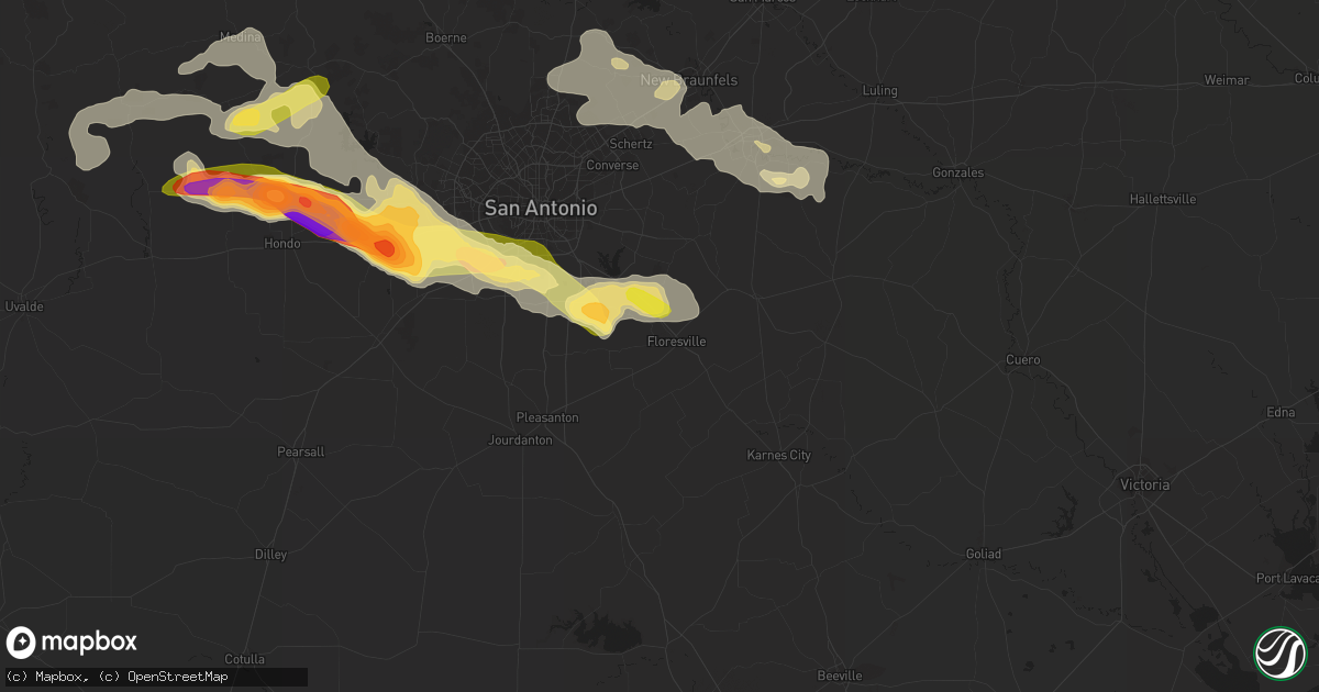
Hail Map in Floresville, TX on May 17, 2016
Get this storm
May 17 map
$229
one time, instant access
Download today. No call, no setup
Keep the $229
Bought the map and want the full workflow? Apply the entire $229 to a subscription within 7 days. None of it is wasted.
Every map, not just this one
This buys you this map. Subscription and you get every map we run, in the markets you choose from a few cities to whole states to nationwide. Plus real-time alerts the moment a storm fires.
Contact data
Name, contact info, occupancy, even credit band for addresses in the footprint. You go from where it hit to who to call.
Become the source they trust
Unlimited branding weather history reports on demand. You already have the documented answer ready for the property owner, and you are the one who showed up with it.
Property data and RoofTrace estimates
Pull up any address you have got, its value and the exact code rules for that jurisdiction, straight from One Click Code. Then RoofTrace estimates the squares, pitch, and roof value, priced the way you price.
Storm reports in Floresville, TX
Floresville, TX
| Date | Description |
|---|---|
| 05/17/201612:45 AM CDT | On fm775 just west of hwy 181 numerous large tree limbs torn off... Quarter size hail reported too |
| 05/17/201612:45 AM CDT | On fm775 between hwy 181 and cr128... Power lines down |
| 05/17/201612:45 AM CDT | Near junction of hwy 97 and fm1344 winds estimated to 60 mph... City power outages reported |
| 05/17/201612:45 AM CDT | Extremely high winds...estimated between 60 and 80 mph... Large tree limbs torn off... Quarter size hail |
| 05/17/201612:15 AM CDT | Multiple reports of trees uprooted or snapped. Some instances with trees falling on cars. Minor structural damage to roofs and siding also reported. |
All States Impacted by Hail Map on May 17, 2016
All Cities Impacted by Hail Map on May 17, 2016
- Sebring, FL
- Ozona, TX
- Laredo, TX
- San Antonio, TX
- Gillett, TX
- Hebbronville, TX
- Saint Cloud, FL
- Comstock, TX
- Cotulla, TX
- Big Wells, TX
- Encinal, TX
- Midkiff, TX
- Utopia, TX
- Cibolo, TX
- Bulverde, TX
- Marion, TX
- New Braunfels, TX
- Roma, TX
- Bandera, TX
- Medina, TX
- Rocksprings, TX
- Sonora, TX
- Rio Grande City, TX
- Barnhart, TX
- Big Lake, TX
- Junction, TX
- Ingram, TX
- Mountain Home, TX
- Kerrville, TX
- Harper, TX
- Iraan, TX
- Victoria, TX
- Fort Pierce, FL
- Floresville, TX
- Santa Elena, TX
- Garciasville, TX
- Zapata, TX
- Spring Branch, TX
- Sedona, AZ
- Hondo, TX
- Pipe Creek, TX
- D Hanis, TX
- La Coste, TX
- Castroville, TX
- Seguin, TX
- Eldorado, TX
- Christoval, TX
- Rio Frio, TX
- Camp Wood, TX
- Leakey, TX
- Del Rio, TX
- Okeechobee, FL
- Indiantown, FL
- Mertzon, TX
- Apollo Beach, FL
- Sun City Center, FL
- Ruskin, FL
- Fredericksburg, TX
- Parrish, FL
- Palmetto, FL
- Wimauma, FL
- Brownfield, TX
- Westhoff, TX
- Brackettville, TX
- Denver City, TX
- Plains, TX
- Lovington, NM
- Tilden, TX
- Roosevelt, TX
- Doss, TX
- London, TX
- Menard, TX
- Comfort, TX
- Hunt, TX
- Center Point, TX
- Fort McKavett, TX
- Naples, FL
- Dryden, TX
- Ochopee, FL
- Old Glory, TX
- Rule, TX
- Aspermont, TX
- Realitos, TX
- Vero Beach, FL
- Concepcion, TX
- Smiley, TX
- Goliad, TX
- White Sands Missile Range, NM
- Brooksville, FL
- Tatum, NM
- Nordheim, TX
- Fellsmere, FL
- Quemado, TX
- McCamey, TX
- Mirando City, TX
- Bruni, TX
- Oilton, TX
- Elmendorf, TX
- Adkins, TX
- Guerra, TX
- Devine, TX
- Immokalee, FL
- Stockdale, TX
- Seagraves, TX
- Reidsville, GA
- Lyons, GA
- Collins, GA
- Mcdonald, NM
- Crane, TX
- Runge, TX
- Kenedy, TX
- Natalia, TX
- Von Ormy, TX
- Mico, TX
- Atascosa, TX
- Rio Medina, TX
- Lytle, TX
- Jbsa Lackland, TX
- La Vernia, TX
- Somerset, TX
- Wauchula, FL
- Willcox, AZ
- Pima, AZ
- Mascotte, FL
- Groveland, FL
- Pine, AZ
- Clewiston, FL
- Hardeeville, SC
- Schertz, TX
- McQueeney, TX
- Bartow, FL
- Sabinal, TX
- Moore Haven, FL
- Beverly Hills, FL
- Lecanto, FL
- Encino, TX
- Lehigh Acres, FL
- Fort Meade, FL
- Cuero, TX
- Cliff, NM
- Buckhorn, NM
- Gila, NM
- Fort Myers, FL
- Reddick, FL
- Redrock, NM
- Estero, FL
- Kings Bay, GA
- Saint Marys, GA
- Port Saint Lucie, FL
- San Angelo, TX
- Rockledge, GA
- Las Cruces, NM
- Avon Park, FL
- Gonzales, TX
- Starke, FL
- Yorktown, TX
- Alpine, TX
- Fort Stockton, TX
- Vancourt, TX
- Carrizo Springs, TX
- Eagle Pass, TX
- Grulla, TX


