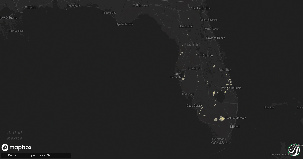
Hail Map in Florida on May 17, 2016
Get this storm
May 17 map
$229
one time, instant access
Download today. No call, no setup
Keep the $229
Bought the map and want the full workflow? Apply the entire $229 to a subscription within 7 days. None of it is wasted.
Every map, not just this one
This buys you this map. Subscription and you get every map we run, in the markets you choose from a few cities to whole states to nationwide. Plus real-time alerts the moment a storm fires.
Contact data
Name, contact info, occupancy, even credit band for addresses in the footprint. You go from where it hit to who to call.
Become the source they trust
Unlimited branding weather history reports on demand. You already have the documented answer ready for the property owner, and you are the one who showed up with it.
Property data and RoofTrace estimates
Pull up any address you have got, its value and the exact code rules for that jurisdiction, straight from One Click Code. Then RoofTrace estimates the squares, pitch, and roof value, priced the way you price.
Storm reports in Florida
Florida
| Date | Description |
|---|---|
| 05/17/20166:15 PM CDT | Trees down reported down on nw 18th terrace...west newberry road...nw 14th avenue..sw 53rd avenue...and nw county road 1493. Time estimated by radar. |
| 05/17/20162:45 PM CDT | Public reported large limbs downed. |
| 05/17/20162:45 PM CDT | Dispatch reported a tree down in the roadway at the intersection of highways 225 and 326. |
| 05/17/20162:18 PM CDT | Camp blanding weather observer reported wind gust to 64 knots/74 mph. A couple of trees were reported down. |
| 05/17/20162:15 PM CDT | Nws survey team determined that an ef-0 tornado with approximate wind speeds of 65 to 75 mph touched down in a trailer park just west of the saint lucie county airport. |
| 05/17/20162:12 PM CDT | Seminole pd reported quarter size hail at the casino |
| 05/17/20161:58 PM CDT | *** 1 inj *** damage to homes in 6500 block of lee blvd... 8100-8300 blocks of fort pierce blvd... 4-5 trailers damaged in road runner trailer park with one injury... Power l |
| 05/17/20161:55 PM CDT | Nws survey team has confirmed a tornado touched down in lakewood park with a well-defined damage path. Information about wind speeds... Path length and width... Including m ( |
| 05/17/20161:54 PM CDT | Damage to around 20 homes... 2 severely damage in 1500 block of 19th place sw... In vero highlands. Also damage to cars... Boats... Fences... Pool enclosures... Carports and |
| 05/17/20161:53 PM CDT | Damage to warehouse roof near intersection of kings hwy and angle rd. Possible tornado. Time estimated from radar. Report relayed from wptv. |
| 05/17/20161:51 PM CDT | Nws storm survey determined ef-1 tornado with path length 0.5 mile long... 75 yards wide... Winds 80-90 mph. Approximately 15 homes damaged... Trees snapped... Fences and poo |
| 05/17/20161:48 PM CDT | Nws storm survey determined an ef-1 tornado with 0.25 mile length... 100 yard width... Winds 80-90 mph. Two homes with major damage... 16 homes with minor damage mainly to ro |
| 05/17/20161:10 PM CDT | 1800 block/14 ave sw... Damage to trees... 1 home... Power lines down. Possible tornado. |
All States Impacted by Hail Map on May 17, 2016
Cities Impacted by Hail Map on May 17, 2016
- Sebring, FL
- Ozona, TX
- Laredo, TX
- San Antonio, TX
- Gillett, TX
- Hebbronville, TX
- Saint Cloud, FL
- Comstock, TX
- Cotulla, TX
- Big Wells, TX
- Encinal, TX
- Midkiff, TX
- Utopia, TX
- Cibolo, TX
- Bulverde, TX
- Marion, TX
- New Braunfels, TX
- Roma, TX
- Bandera, TX
- Medina, TX
- Rocksprings, TX
- Sonora, TX
- Rio Grande City, TX
- Barnhart, TX
- Big Lake, TX
- Junction, TX
- Ingram, TX
- Mountain Home, TX
- Kerrville, TX
- Harper, TX
- Iraan, TX
- Victoria, TX
- Fort Pierce, FL
- Floresville, TX
- Santa Elena, TX
- Garciasville, TX
- Zapata, TX
- Spring Branch, TX
- Sedona, AZ
- Hondo, TX
- Pipe Creek, TX
- D Hanis, TX
- La Coste, TX
- Castroville, TX
- Seguin, TX
- Eldorado, TX
- Christoval, TX
- Rio Frio, TX
- Camp Wood, TX
- Leakey, TX
- Del Rio, TX
- Okeechobee, FL
- Indiantown, FL
- Mertzon, TX
- Apollo Beach, FL
- Sun City Center, FL
- Ruskin, FL
- Fredericksburg, TX
- Parrish, FL
- Palmetto, FL
- Wimauma, FL
- Brownfield, TX
- Westhoff, TX
- Brackettville, TX
- Denver City, TX
- Plains, TX
- Lovington, NM
- Tilden, TX
- Roosevelt, TX
- Doss, TX
- London, TX
- Menard, TX
- Comfort, TX
- Hunt, TX
- Center Point, TX
- Fort McKavett, TX
- Naples, FL
- Dryden, TX
- Ochopee, FL
- Old Glory, TX
- Rule, TX
- Aspermont, TX
- Realitos, TX
- Vero Beach, FL
- Concepcion, TX
- Smiley, TX
- Goliad, TX
- White Sands Missile Range, NM
- Brooksville, FL
- Tatum, NM
- Nordheim, TX
- Fellsmere, FL
- Quemado, TX
- McCamey, TX
- Mirando City, TX
- Bruni, TX
- Oilton, TX
- Elmendorf, TX
- Adkins, TX
- Guerra, TX
- Devine, TX
- Immokalee, FL
- Stockdale, TX
- Seagraves, TX
- Reidsville, GA
- Lyons, GA
- Collins, GA
- Mcdonald, NM
- Crane, TX
- Runge, TX
- Kenedy, TX
- Natalia, TX
- Von Ormy, TX
- Mico, TX
- Atascosa, TX
- Rio Medina, TX
- Lytle, TX
- Jbsa Lackland, TX
- La Vernia, TX
- Somerset, TX
- Wauchula, FL
- Willcox, AZ
- Pima, AZ
- Mascotte, FL
- Groveland, FL
- Pine, AZ
- Clewiston, FL
- Hardeeville, SC
- Schertz, TX
- McQueeney, TX
- Bartow, FL
- Sabinal, TX
- Moore Haven, FL
- Beverly Hills, FL
- Lecanto, FL
- Encino, TX
- Lehigh Acres, FL
- Fort Meade, FL
- Cuero, TX
- Cliff, NM
- Buckhorn, NM
- Gila, NM
- Fort Myers, FL
- Reddick, FL
- Redrock, NM
- Estero, FL
- Kings Bay, GA
- Saint Marys, GA
- Port Saint Lucie, FL
- San Angelo, TX
- Rockledge, GA
- Las Cruces, NM
- Avon Park, FL
- Gonzales, TX
- Starke, FL
- Yorktown, TX
- Alpine, TX
- Fort Stockton, TX
- Vancourt, TX
- Carrizo Springs, TX
- Eagle Pass, TX
- Grulla, TX


