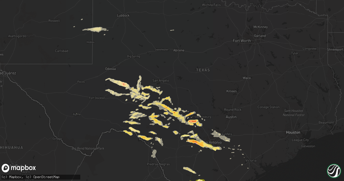
Hail Map in Texas on May 17, 2016
Get this storm
May 17 map
$229
one time, instant access
Download today. No call, no setup
Keep the $229
Bought the map and want the full workflow? Apply the entire $229 to a subscription within 7 days. None of it is wasted.
Every map, not just this one
This buys you this map. Subscription and you get every map we run, in the markets you choose from a few cities to whole states to nationwide. Plus real-time alerts the moment a storm fires.
Contact data
Name, contact info, occupancy, even credit band for addresses in the footprint. You go from where it hit to who to call.
Become the source they trust
Unlimited branding weather history reports on demand. You already have the documented answer ready for the property owner, and you are the one who showed up with it.
Property data and RoofTrace estimates
Pull up any address you have got, its value and the exact code rules for that jurisdiction, straight from One Click Code. Then RoofTrace estimates the squares, pitch, and roof value, priced the way you price.
Storm reports in Texas
Texas
| Date | Description |
|---|---|
| 05/17/20166:30 PM CDT | Four inch diameter live oak tree limbs snapped off by high winds. |
| 05/17/20166:29 PM CDT | Hail occurred along highway 190 just east of the menard and shleicher county line. |
| 05/17/20166:20 PM CDT | A local report indicates 1.25 inch wind near 5 NW FORT MCKAVETT |
| 05/17/20165:42 PM CDT | A local report indicates 1.00 inch wind near 6 S CHRISTOVAL |
| 05/17/20165:15 PM CDT | A local report indicates a tornado near 12 N OZONA |
| 05/17/20165:07 PM CDT | Hail occurred at the intersection of highway 190 and county road 204. |
| 05/17/20165:07 PM CDT | A local report indicates 1.00 inch wind near 15 NW OZONA |
| 05/17/20165:02 PM CDT | Nickel to quarter size hail fell on highway 67 between 502 and 506 pm cdt. |
| 05/17/20164:37 PM CDT | A local report indicates 1.75 inch wind near 7 SW MERTZON |
| 05/17/20163:52 PM CDT | A local report indicates 1.25 inch wind near 9 NNW TEXON |
| 05/17/20163:38 PM CDT | A local report indicates 1.75 inch wind near 7 N RANKIN |
| 05/17/20163:28 PM CDT | Broken windshield on car. |
| 05/17/20163:19 PM CDT | A local report indicates 1.75 inch wind near 7 N RANKIN |
| 05/17/20162:42 PM CDT | A local report indicates 1.00 inch wind near 19 NW RANKIN |
| 05/17/201612:45 AM CDT | On fm775 between hwy 181 and cr128... Power lines down |
| 05/17/201612:45 AM CDT | Near junction of hwy 97 and fm1344 winds estimated to 60 mph... City power outages reported |
| 05/17/201612:45 AM CDT | Extremely high winds...estimated between 60 and 80 mph... Large tree limbs torn off... Quarter size hail |
| 05/17/201612:45 AM CDT | On fm775 just west of hwy 181 numerous large tree limbs torn off... Quarter size hail reported too |
| 05/17/201612:20 AM CDT | Video posted on facebook indicated hen egg size hail falling on carport on la sagunada road north of rio grand city. |
| 05/17/201612:15 AM CDT | Multiple reports of trees uprooted or snapped. Some instances with trees falling on cars. Minor structural damage to roofs and siding also reported. |
| 05/17/201612:10 AM CDT | Near loop 1604 and i37 on the southeast side of san antonio... Corrugated metal roofing ripped back and torn off a car port and shed building |
| 05/17/201612:00 AM CDT | Public via social media reports golf ball size hail in el sauz at midnight. |
| 05/16/201611:55 PM CDT | Six inch tree limbs down. |
| 05/16/201611:40 PM CDT | Picture on twitter of overturned large fifth wheel travel trailer. Time estimated from radar. |
| 05/16/201611:25 PM CDT | Near fm1796 and cr321 |
| 05/16/201611:15 PM CDT | Via spotter network |
| 05/16/201611:04 PM CDT | A local report indicates 1.75 inch wind near 3 W CASTROVILLE |
| 05/16/201611:00 PM CDT | Delayed report...baseball to tea cup size hail observed |
| 05/16/201610:58 PM CDT | Golf ball sized hail in castroville |
| 05/16/201610:48 PM CDT | A local report indicates 2.00 inch wind near 7 W CASTROVILLE |
| 05/16/201610:34 PM CDT | Ping pong ball sized hail reported in the town of quihi. |
| 05/16/201610:11 PM CDT | Corrected hail size after receiving picture with hailstone against a ruler. Teacup sized hail 6 miles north of hondo. |
| 05/16/201610:00 PM CDT | A local report indicates 1.25 inch wind near 4 NW INGRAM |
| 05/16/201610:00 PM CDT | A local report indicates 1.75 inch wind near 5 N KERRVILLE |
| 05/16/20169:51 PM CDT | A local report indicates 2.50 inch wind near 4 N KERRVILLE |
| 05/16/20169:45 PM CDT | A local report indicates 1.75 inch wind near 4 ENE INGRAM |
| 05/16/20169:40 PM CDT | A local report indicates 3.00 inch wind near INGRAM |
| 05/16/20169:35 PM CDT | A local report indicates 2.75 inch wind near 3 NNW INGRAM |
| 05/16/20168:34 PM CDT | A local report indicates 1.50 inch wind near 3 N HARPER |
| 05/16/20168:20 PM CDT | Along highway 290 approximately 5 miles west of harper. |
| 05/16/20168:06 PM CDT | Uss 377 and fox hollow road |
| 05/16/20167:30 PM CDT | Picture received from social media of hail in excess of three inches diameter. |
| 05/16/20167:25 PM CDT | Hail fell for approximately 5 minutes along highway 190. |
| 05/16/20167:20 PM CDT | Golf ball to baseball size hail damaged skylights. |
| 05/16/20167:20 PM CDT | Numerous tree branches down |
| 05/16/20167:20 PM CDT | Photo on social media of hail at least baseball sized in ranchitos las lomas. Time estimated by radar. |
| 05/16/20167:00 PM CDT | Golf ball hail |
All States Impacted by Hail Map on May 17, 2016
Cities Impacted by Hail Map on May 17, 2016
- Sebring, FL
- Ozona, TX
- Laredo, TX
- San Antonio, TX
- Gillett, TX
- Hebbronville, TX
- Saint Cloud, FL
- Comstock, TX
- Cotulla, TX
- Big Wells, TX
- Encinal, TX
- Midkiff, TX
- Utopia, TX
- Cibolo, TX
- Bulverde, TX
- Marion, TX
- New Braunfels, TX
- Roma, TX
- Bandera, TX
- Medina, TX
- Rocksprings, TX
- Sonora, TX
- Rio Grande City, TX
- Barnhart, TX
- Big Lake, TX
- Junction, TX
- Ingram, TX
- Mountain Home, TX
- Kerrville, TX
- Harper, TX
- Iraan, TX
- Victoria, TX
- Fort Pierce, FL
- Floresville, TX
- Santa Elena, TX
- Garciasville, TX
- Zapata, TX
- Spring Branch, TX
- Sedona, AZ
- Hondo, TX
- Pipe Creek, TX
- D Hanis, TX
- La Coste, TX
- Castroville, TX
- Seguin, TX
- Eldorado, TX
- Christoval, TX
- Rio Frio, TX
- Camp Wood, TX
- Leakey, TX
- Del Rio, TX
- Okeechobee, FL
- Indiantown, FL
- Mertzon, TX
- Apollo Beach, FL
- Sun City Center, FL
- Ruskin, FL
- Fredericksburg, TX
- Parrish, FL
- Palmetto, FL
- Wimauma, FL
- Brownfield, TX
- Westhoff, TX
- Brackettville, TX
- Denver City, TX
- Plains, TX
- Lovington, NM
- Tilden, TX
- Roosevelt, TX
- Doss, TX
- London, TX
- Menard, TX
- Comfort, TX
- Hunt, TX
- Center Point, TX
- Fort McKavett, TX
- Naples, FL
- Dryden, TX
- Ochopee, FL
- Old Glory, TX
- Rule, TX
- Aspermont, TX
- Realitos, TX
- Vero Beach, FL
- Concepcion, TX
- Smiley, TX
- Goliad, TX
- White Sands Missile Range, NM
- Brooksville, FL
- Tatum, NM
- Nordheim, TX
- Fellsmere, FL
- Quemado, TX
- McCamey, TX
- Mirando City, TX
- Bruni, TX
- Oilton, TX
- Elmendorf, TX
- Adkins, TX
- Guerra, TX
- Devine, TX
- Immokalee, FL
- Stockdale, TX
- Seagraves, TX
- Reidsville, GA
- Lyons, GA
- Collins, GA
- Mcdonald, NM
- Crane, TX
- Runge, TX
- Kenedy, TX
- Natalia, TX
- Von Ormy, TX
- Mico, TX
- Atascosa, TX
- Rio Medina, TX
- Lytle, TX
- Jbsa Lackland, TX
- La Vernia, TX
- Somerset, TX
- Wauchula, FL
- Willcox, AZ
- Pima, AZ
- Mascotte, FL
- Groveland, FL
- Pine, AZ
- Clewiston, FL
- Hardeeville, SC
- Schertz, TX
- McQueeney, TX
- Bartow, FL
- Sabinal, TX
- Moore Haven, FL
- Beverly Hills, FL
- Lecanto, FL
- Encino, TX
- Lehigh Acres, FL
- Fort Meade, FL
- Cuero, TX
- Cliff, NM
- Buckhorn, NM
- Gila, NM
- Fort Myers, FL
- Reddick, FL
- Redrock, NM
- Estero, FL
- Kings Bay, GA
- Saint Marys, GA
- Port Saint Lucie, FL
- San Angelo, TX
- Rockledge, GA
- Las Cruces, NM
- Avon Park, FL
- Gonzales, TX
- Starke, FL
- Yorktown, TX
- Alpine, TX
- Fort Stockton, TX
- Vancourt, TX
- Carrizo Springs, TX
- Eagle Pass, TX
- Grulla, TX


