Hail Map in Houston, TX on May 16, 2024
The weather event in Houston, TX on May 16, 2024 includes Hail, Wind, and Tornado maps. 11 states and 602 cities were impacted and suffered possible damage. The total estimated number of properties impacted is 0.
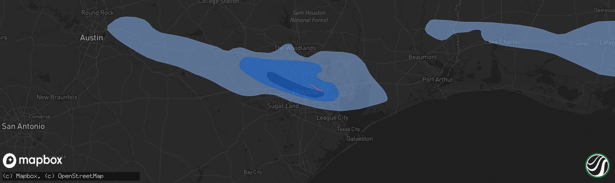
Hail
Wind
Tornado
0
Estimated number of impacted properties by a 1.00" hail or larger0
Estimated number of impacted properties by a 1.75" hail or larger0
Estimated number of impacted properties by a 2.50" hail or largerStorm reports in Houston, TX
Houston, TX
| Date | Description |
|---|---|
| 05/16/20246:55 PM CDT | Awos station kmcj houston univ. |
| 05/16/20246:43 PM CDT | Numerous windows blown out downtown skyscrapers. |
| 05/16/20246:41 PM CDT | Widespread trees downed across the area. Homes damaged throughout the neighborhood. |
| 05/16/20246:39 PM CDT | Multiple trees down. Denver harbor area. |
| 05/16/20246:30 PM CDT | Large trees down i45 & parker rd. |
| 05/16/20246:30 PM CDT | *** 4 fatal *** 4 confirmed fatalities and 1 unconfirmed fatality across different locations across the houston metro area from fallen trees and a crane incident. |
| 05/16/20246:15 PM CDT | Multiple trees down. |
| 05/15/20247:00 PM CDT | Asos station khou houston hobby. |
All States Impacted by Hail Map on May 16, 2024
All Cities Impacted by Hail Map on May 16, 2024
- Graford, TX
- Perrin, TX
- Mineral Wells, TX
- Palo Pinto, TX
- Santo, TX
- Millsap, TX
- Tolar, TX
- Granbury, TX
- Bluff Dale, TX
- Glen Rose, TX
- Rainbow, TX
- Nemo, TX
- Kopperl, TX
- Blackwell, TX
- Tatum, NM
- Ballinger, TX
- Ozona, TX
- Rowena, TX
- Paint Rock, TX
- Millersview, TX
- Tuscola, TX
- Voss, TX
- Merkel, TX
- Eldorado, TX
- Gouldbusk, TX
- Elida, NM
- Abilene, TX
- Rockwood, TX
- Santa Anna, TX
- Coleman, TX
- Alto, NM
- Nogal, NM
- Rochelle, TX
- Brookesmith, TX
- Pep, NM
- West, TX
- Fairfield, TX
- Brownwood, TX
- Elm Mott, TX
- Waco, TX
- Mullin, TX
- Richland Springs, TX
- Axtell, TX
- Mount Calm, TX
- Trent, TX
- Muleshoe, TX
- Christoval, TX
- Goldthwaite, TX
- Prairie Hill, TX
- Mart, TX
- Coahoma, TX
- Ira, TX
- San Saba, TX
- Lenorah, TX
- Knott, TX
- Snyder, TX
- Menard, TX
- Immokalee, FL
- Big Spring, TX
- Gail, TX
- Eden, TX
- Tinnie, NM
- Lometa, TX
- Star, TX
- Lampasas, TX
- Weed, NM
- Pinon, NM
- Hermleigh, TX
- Copperas Cove, TX
- Gatesville, TX
- Stamford, TX
- Evant, TX
- Rotan, TX
- Nacogdoches, TX
- Fluvanna, TX
- Sweetwater, TX
- Hext, TX
- Chireno, TX
- Justiceburg, TX
- Bent, NM
- Roswell, NM
- Fort Hood, TX
- San Augustine, TX
- Center, TX
- Grapeland, TX
- Kennard, TX
- Hamlin, TX
- Roby, TX
- Rusk, TX
- Fort Sumner, NM
- Crockett, TX
- Sudan, TX
- Mason, TX
- McCaulley, TX
- Temple, TX
- Lufkin, TX
- Brady, TX
- Moody, TX
- Theriot, LA
- Alto, TX
- Wells, TX
- Kempner, TX
- Pollok, TX
- Troy, TX
- Post, TX
- Fredonia, TX
- Huntington, TX
- Broaddus, TX
- Killeen, TX
- Zavalla, TX
- Lovelady, TX
- Hagerman, NM
- Seminole, TX
- Bronson, TX
- Pennington, TX
- Groveton, TX
- Tow, TX
- Maljamar, NM
- Pineland, TX
- Lovington, NM
- Hemphill, TX
- Harker Heights, TX
- Nolan, TX
- Denver City, TX
- Belton, TX
- Andrews, TX
- Burnet, TX
- Calico Rock, AR
- Salt Flat, TX
- Caldwell, TX
- Anderson, TX
- Jefferson, WI
- Helenville, WI
- Jal, NM
- Hobbs, NM
- Deridder, LA
- Pitkin, LA
- Sugartown, LA
- Eunice, NM
- College Station, TX
- Bedias, TX
- Plains, TX
- Goodrich, TX
- Shepherd, TX
- Livingston, TX
- Huntsville, TX
- Kirbyville, TX
- Jasper, TX
- Newton, TX
- Iola, TX
- Richards, TX
- Colmesneil, TX
- Kermit, TX
- Midkiff, TX
- Lincoln, TX
- Giddings, TX
- Barstow, TX
- Dry Creek, LA
- Coldspring, TX
- Woodville, TX
- Big Lake, TX
- Monahans, TX
- Cleveland, TX
- New Caney, TX
- Splendora, TX
- Brackettville, TX
- Ville Platte, LA
- Opelousas, LA
- Washington, LA
- Bon Wier, TX
- Conroe, TX
- Dime Box, TX
- Grandfalls, TX
- Warren, TX
- Bunkie, LA
- Uvalde, TX
- Ledbetter, TX
- Dayton, TX
- Palmetto, LA
- Plaucheville, LA
- Melville, LA
- Notrees, TX
- Goldsmith, TX
- Seagraves, TX
- Dimmitt, TX
- Whitewater, MT
- Morganza, LA
- Batchelor, LA
- Merryville, LA
- Burkeville, TX
- New Roads, LA
- Brenham, TX
- Chappell Hill, TX
- Odessa, TX
- Barnhart, TX
- Mertzon, TX
- Hempstead, TX
- Washington, TX
- Navasota, TX
- Nazareth, TX
- Saratoga, TX
- Gardendale, TX
- Bellville, TX
- Brookshire, TX
- Sealy, TX
- Prairie View, TX
- Waller, TX
- Katy, TX
- Hockley, TX
- Cypress, TX
- Tomball, TX
- Magnolia, TX
- Tokio, TX
- Brownfield, TX
- Morton, TX
- Sundown, TX
- Meadow, TX
- Whiteface, TX
- Levelland, TX
- Littlefield, TX
- Wolfforth, TX
- Smyer, TX
- Ropesville, TX
- Lubbock, TX
- Shallowater, TX
- Anton, TX
- Singer, LA
- Kountze, TX
- Saint Martinville, LA
- Grosse Tete, LA
- Midland, TX
- Houston, TX
- Crane, TX
- Tulia, TX
- Longville, LA
- Sour Lake, TX
- Batson, TX
- Idalou, TX
- Abernathy, TX
- Petersburg, TX
- New Deal, TX
- Stanton, TX
- Spring, TX
- Mittie, LA
- Silsbee, TX
- Liberty, TX
- Port Allen, LA
- Brusly, LA
- Addis, LA
- Grant, LA
- McCamey, TX
- Lorenzo, TX
- Oberlin, LA
- Kinder, LA
- Hull, TX
- Buna, TX
- Fred, TX
- Baker, LA
- Baton Rouge, LA
- Reeves, LA
- Vida, MT
- Lumberton, TX
- Richmond, TX
- Rosenberg, TX
- Wallis, TX
- Oakdale, LA
- Humble, TX
- Elizabeth, LA
- South Houston, TX
- Bellaire, TX
- Pasadena, TX
- Galena Park, TX
- Deer Park, TX
- Channelview, TX
- Highlands, TX
- Hale Center, TX
- Plainview, TX
- Garden City, TX
- San Angelo, TX
- Mamou, LA
- Opheim, MT
- Seabrook, TX
- Baytown, TX
- La Porte, TX
- Webster, TX
- Crosby, TX
- Floydada, TX
- Lockney, TX
- Ralls, TX
- Kemah, TX
- League City, TX
- Anahuac, TX
- Wallisville, TX
- Wayside, TX
- Happy, TX
- Pearland, TX
- Fresno, TX
- Rankin, TX
- Claude, TX
- Jackson, LA
- Kaukauna, WI
- Kyle, SD
- Mchenry, ND
- Vidor, TX
- Seymour, WI
- De Pere, WI
- Call, TX
- Basile, LA
- Elton, LA
- Deweyville, TX
- Sterling City, TX
- Winnie, TX
- Vancourt, TX
- Starks, LA
- Richland, MT
- Eunice, LA
- Pearlington, MS
- Bay Saint Louis, MS
- Orange, TX
- Pinehurst, TX
- Kingwood, TX
- Porter, TX
- Huffman, TX
- Hankamer, TX
- Bleiblerville, TX
- Cat Spring, TX
- New Ulm, TX
- Vinton, LA
- Dequincy, LA
- Sulphur, LA
- Fulshear, TX
- Waveland, MS
- Burton, TX
- Industry, TX
- Fayetteville, TX
- Round Top, TX
- Paige, TX
- Carmine, TX
- Lexington, TX
- La Grange, TX
- Smithville, TX
- Bastrop, TX
- McDade, TX
- Manor, TX
- Elgin, TX
- Coupland, TX
- Taylor, TX
- Thrall, TX
- Binford, ND
- Porcupine, SD
- Allen, SD
- Wanblee, SD
- New Rockford, ND
- Glenfield, ND
- Cameron, LA
- Lake Charles, LA
- Ragley, LA
- Cooperstown, ND
- Port Arthur, TX
- Melvin, TX
- Pine Ridge, SD
- Carlsbad, TX
- Robert Lee, TX
- Hannaford, ND
- Bell City, LA
- Martin, SD
- Hackberry, LA
- Art, TX
- Castell, TX
- Iota, LA
- Jennings, LA
- Evangeline, LA
- Comstock, TX
- Voca, TX
- Fordoche, LA
- Port Barre, LA
- Krotz Springs, LA
- Saint Francisville, LA
- Roanoke, LA
- Childress, TX
- Luverne, ND
- Morse, LA
- Mermentau, LA
- Egan, LA
- Llano, TX
- Grand Chenier, LA
- Kaplan, LA
- Gueydan, LA
- Pontotoc, TX
- Valley Spring, TX
- Hope, ND
- Sonora, TX
- Dazey, ND
- Livonia, LA
- Lottie, LA
- Maringouin, LA
- Jarreau, LA
- Oscar, LA
- Lakeland, LA
- Rayne, LA
- Creole, LA
- Maurice, LA
- Duson, LA
- Rougon, LA
- Ventress, LA
- Glynn, LA
- Erwinville, LA
- Zachary, LA
- Slaughter, LA
- Ethel, LA
- Pillsbury, ND
- Bluffton, TX
- Abbeville, LA
- Rocksprings, TX
- Lafayette, LA
- Youngsville, LA
- Page, ND
- Lake Arthur, LA
- Welsh, LA
- Church Point, LA
- Branch, LA
- Crowley, LA
- Estherwood, LA
- Carencro, LA
- Sunset, LA
- Arnaudville, LA
- Scott, LA
- New Iberia, LA
- Delcambre, LA
- Broussard, LA
- Erath, LA
- Breaux Bridge, LA
- Loreauville, LA
- Jeanerette, LA
- Greensburg, LA
- Pride, LA
- Clinton, LA
- Greenwell Springs, LA
- Denham Springs, LA
- Buchanan Dam, TX
- Kentwood, LA
- Walker, LA
- Pine Grove, LA
- Amite, LA
- Holden, LA
- Plaquemine, LA
- Rosedale, LA
- Sunshine, LA
- Franklin, LA
- Baldwin, LA
- Pierre Part, LA
- Morgan City, LA
- White Castle, LA
- Gonzales, LA
- Darrow, LA
- Sorrento, LA
- Belle Rose, LA
- Corsicana, TX
- Weatherford, TX
- Purdon, TX
- Richland, TX
- Geismar, LA
- Donaldsonville, LA
- Salado, TX
- Napoleonville, LA
- Streetman, TX
- Roseland, LA
- Independence, LA
- Livingston, LA
- Plattenville, LA
- Saint Gabriel, LA
- Carville, LA
- Convent, LA
- Paulina, LA
- Leakey, TX
- Saint James, LA
- Tickfaw, LA
- Hammond, LA
- Ponchatoula, LA
- Hunt, TX
- Loranger, LA
- Vanderpool, TX
- Ama, LA
- Medina, TX
- New Orleans, LA
- Westwego, LA
- Marrero, LA
- Kenner, LA
- Metairie, LA
- Prairieville, LA
- French Settlement, LA
- Albany, LA
- Springfield, LA
- Abita Springs, LA
- Robert, LA
- Madisonville, LA
- Covington, LA
- Mandeville, LA
- Lacombe, LA
- Bandera, TX
- Pipe Creek, TX
- Barataria, LA
- Lafitte, LA
- Cut Off, LA
- Lockport, LA
- Edgard, LA
- Raceland, LA
- Lutcher, LA
- Des Allemands, LA
- Hahnville, LA
- Thibodaux, LA
- Vacherie, LA
- Gray, LA
- Labadieville, LA
- Houma, LA
- Schriever, LA
- Mathews, LA
- Gheens, LA
- Boutte, LA
- Luling, LA
- Reserve, LA
- Destrehan, LA
- Saint Amant, LA
- La Place, LA
- Saint Rose, LA
- Garyville, LA
- Gramercy, LA
- Mount Airy, LA
- Paradis, LA
- Norco, LA
- Maurepas, LA
- Helotes, TX
- Arabi, LA
- Port Sulphur, LA
- Belle Chasse, LA
- Violet, LA
- Gretna, LA
- Meraux, LA
- Chalmette, LA
- Saint Bernard, LA
- Braithwaite, LA
- Harvey, LA
- Berwick, LA
- Patterson, LA
- Pearl River, LA
- Slidell, LA
- Gulfport, MS
- Long Beach, MS
- Stennis Space Center, MS
- Pass Christian, MS
- Picayune, MS
- Kiln, MS
- Diamondhead, MS
- Lumberton, MS
- Wiggins, MS
- Poplarville, MS
- Brooklyn, MS
- Eagle Pass, TX
- Laredo, TX
- Lucedale, MS
- Cotulla, TX
- Chunchula, AL
- Axis, AL
- Encinal, TX
- Wilmer, AL
- Citronelle, AL
- Calliham, TX
- Creola, AL
- Saraland, AL
- Tilden, TX
- Saucier, MS
- Three Rivers, TX
- Bay Minette, AL
- McLain, MS
- George West, TX
- Lacassine, LA
- Westlake, LA
- Iowa, LA
- Golden Meadow, LA
- Galliano, LA
- Larose, LA
- Grand Isle, LA
- Buras, LA
- Venice, LA
- Port Saint Joe, FL
- Eastpoint, FL
- Apalachicola, FL
- Wewahitchka, FL
- Summerdale, AL
- Pensacola, FL
- Silverhill, AL
- Robertsdale, AL
- Bon Secour, AL
- Loxley, AL
- Magnolia Springs, AL
- Orange Beach, AL
- Gulf Shores, AL
- Lillian, AL
- Fairhope, AL
- Daphne, AL
- Foley, AL
- Elberta, AL


