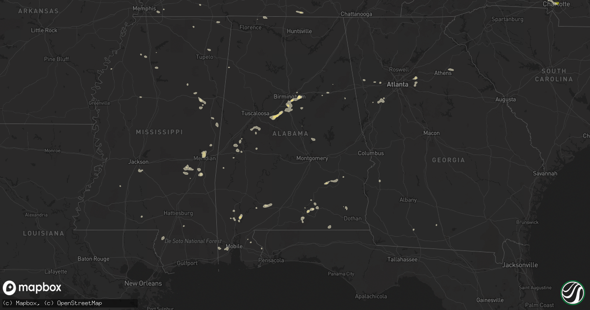
Hail Map in Alabama on May 16, 2023
Get this storm
May 16 map
$229
one time, instant access
Download today. No call, no setup
Keep the $229
Bought the map and want the full workflow? Apply the entire $229 to a subscription within 7 days. None of it is wasted.
Every map, not just this one
This buys you this map. Subscription and you get every map we run, in the markets you choose from a few cities to whole states to nationwide. Plus real-time alerts the moment a storm fires.
Contact data
Name, contact info, occupancy, even credit band for addresses in the footprint. You go from where it hit to who to call.
Become the source they trust
Unlimited branding weather history reports on demand. You already have the documented answer ready for the property owner, and you are the one who showed up with it.
Property data and RoofTrace estimates
Pull up any address you have got, its value and the exact code rules for that jurisdiction, straight from One Click Code. Then RoofTrace estimates the squares, pitch, and roof value, priced the way you price.
Storm reports in Alabama
Alabama
| Date | Description |
|---|---|
| 05/16/20235:55 PM CDT | Power lines were blown down near the intersection of cr 58 and county line rd. Along the lauderdale-limestone county border. Specific time of event based on radar data. |
| 05/16/20235:55 PM CDT | Trees and power lines were blow down near the intersection of garrison rd. And targum rd. In hartselle... With reports relayed from ema and broadcast media. Specific ti |
| 05/16/20235:54 PM CDT | Limestone county ema director estimated a wind gust of at least 60 mph at this location. Specific time of event based on radar data. |
| 05/16/20235:43 PM CDT | A large pine tree was uprooted near the intersection of cr 52 and cr 89 to the northwest of anderson. Specific time of event based on radar data. |
| 05/16/20235:21 PM CDT | Section of roof blown off an outbuilding/barn-like structure. |
| 05/16/20234:37 PM CDT | Multiple reports of downed trees along highway 20 and highway 22 between phil campbell and russellville. Specific time of event based on radar data. |
| 05/16/20232:42 PM CDT | Trees down in numerous locations throughout talladega county. Roadways blocked in several locations. |
| 05/16/20232:40 PM CDT | Fences and awnings blown down along county road 36. Radar showed a microburst at this location. |
| 05/16/20231:33 PM CDT | Trees reported down in leeds. |
| 05/16/20231:22 PM CDT | Tree fell through the roof of a residence. No injuries reported. |
| 05/16/20231:18 PM CDT | Large oak trees uprooted in moody. |
| 05/15/20239:48 PM CDT | A metal roof was peeled off of a church at 22870 sandlin road. Trees were also knocked down in the area. Time estimated by radar associated with an apparent gust front. |
All States Impacted by Hail Map on May 16, 2023
Cities Impacted by Hail Map on May 16, 2023
- Lebanon, KY
- Bradfordsville, KY
- Gravel Switch, KY
- Parksville, KY
- Hustonville, KY
- Junction City, KY
- Stanford, KY
- Richmond, KY
- Waco, KY
- Irvine, KY
- Clay City, KY
- Winchester, KY
- Waynesburg, KY
- Crab Orchard, KY
- Lancaster, KY
- Mount Vernon, KY
- Brodhead, KY
- Berea, KY
- McKee, KY
- Orlando, KY
- Manchester, KY
- Sextons Creek, KY
- Booneville, KY
- Sandgap, KY
- Oneida, KY
- Mistletoe, KY
- Buckhorn, KY
- Knoxville, TN
- Corryton, TN
- Bonnyman, KY
- Hazard, KY
- Bulan, KY
- Dwarf, KY
- Oak Ridge, TN
- Carrie, KY
- Jackhorn, KY
- Virgie, KY
- Jenkins, KY
- Neon, KY
- McRoberts, KY
- Deane, KY
- Shelby Gap, KY
- Clintwood, VA
- Pound, VA
- Clinchco, VA
- Haysi, VA
- Birchleaf, VA
- Bee, VA
- Dante, VA
- Vansant, VA
- Grundy, VA
- Davenport, VA
- Oakwood, VA
- Rowe, VA
- Morganton, NC
- Bostic, NC
- Raven, VA
- Jewell Ridge, VA
- Whitewood, VA
- Casar, NC
- Richlands, VA
- Bandy, VA
- Pennington Gap, VA
- Tazewell, VA
- North Tazewell, VA
- Cedar Bluff, VA
- Squire, WV
- Berwind, WV
- Roxboro, NC
- Cherryville, NC
- Lawndale, NC
- Vale, NC
- Bluefield, VA
- Bastian, VA
- Ceres, VA
- Rocky Gap, VA
- Martinsville, VA
- Callands, VA
- Millers Creek, NC
- McGrady, NC
- North Wilkesboro, NC
- Hays, NC
- Danville, VA
- Dry Fork, VA
- Blairs, VA
- Ringgold, VA
- Sutherlin, VA
- Keeling, VA
- Alton, VA
- South Boston, VA
- Semora, NC
- Virgilina, VA
- Oxford, NC
- Charlotte, NC
- Crouse, NC
- Axton, VA
- Chesterfield, VA
- Richmond, VA
- Dryden, VA
- Brogan, OR
- Vale, OR
- Harper, OR
- Baker City, OR
- Parks, NE
- Champion, NE
- Haigler, NE
- Saint Francis, KS
- Krypton, KY
- Busy, KY
- Hyden, KY
- Hindman, KY
- Pikeville, KY
- Raccoon, KY
- Kimper, KY
- Mount Airy, NC
- Ararat, NC
- Pilot Mountain, NC
- Westfield, NC
- Claudville, VA
- Stuart, VA
- Lawsonville, NC
- Radford, VA
- Dublin, VA
- Starkville, MS
- Sevierville, TN
- Poplarville, MS
- Ozark, AL
- Kalispell, MT
- Kila, MT
- Corbin, KY
- Parkers Lake, KY
- Akron, CO
- Clinton, TN
- Oliver Springs, TN
- Spring Branch, TX
- Bergheim, TX
- Kendalia, TX
- Union Springs, AL
- Midway, AL
- Batchelor, LA
- Adrian, TX
- Andalusia, AL
- Gantt, AL
- Opp, AL
- Forkland, AL
- Boligee, AL
- Titus, AL
- Watson, AR
- Baskerville, VA
- Bracey, VA
- Matagorda, TX
- Bay City, TX
- Imperial, NE
- Clayhole, KY
- Bay Minette, AL
- Union Mills, NC
- Bessemer City, NC
- Nebo, NC
- Ellenboro, NC
- Shelby, NC
- Troy, AL
- Banks, AL
- Jackson, KY
- Lewellen, NE
- York, AL
- Penhook, VA
- Chatham, VA
- Rocky Mount, VA
- Quitman, MS
- Jackson, AL
- Moundville, AL
- Marion, NC
- Pine Top, KY
- Germantown, TN
- Collierville, TN
- Bullock, NC
- Milton, NC
- Snellville, GA
- Grayson, GA
- Loganville, GA
- Cumberland, KY
- Leeds, AL
- Washburn, TN
- Sidney, NE
- Leoti, KS
- Rudyard, MT
- Talladega, AL
- Phyllis, KY
- Mississippi State, MS
- Geyser, MT
- Mantee, MS
- Shepherd, MT
- Pounding Mill, VA
- Adel, GA
- Rutledge, TN
- Meadows Of Dan, VA
- Florence, AL
- Killen, AL
- Livingston, AL
- Salyersville, KY
- Ivel, KY
- Gunlock, KY
- Grethel, KY
- McDowell, KY
- Printer, KY
- Pinsonfork, KY
- Tram, KY
- Banner, KY
- David, KY
- Teaberry, KY
- Martin, KY
- McAndrews, KY
- Harold, KY
- Langley, KY
- Dana, KY
- Betsy Layne, KY
- Prestonsburg, KY
- Stanville, KY
- Shelbiana, KY
- Newnan, GA
- Louin, MS
- Rose Hill, MS
- McIntosh, AL
- Palacios, TX
- Monroeville, AL
- Repton, AL
- Frisco City, AL
- Birmingham, AL
- Pelham, AL
- Helena, AL
- Oxford, AL
- Eastaboga, AL
- Anniston, AL
- West Blocton, AL
- Woodstock, AL
- Midland City, AL
- Batesville, MS
- Bessemer, AL
- Alabaster, AL
- Oakland, MS
- Coffeeville, MS
- Chavies, KY
- Vicco, KY
- Sassafras, KY
- Slidell, LA
- New Orleans, LA
- Henry, VA
- Collinsville, VA
- Bassett, VA
- Conyers, GA
- South Hill, VA
- Chase City, VA
- Boydton, VA
- Skipwith, VA
- Julesburg, CO
- Buchanan, GA
- Bremen, GA
- Macon, MS
- Weaver, AL
- Geneva, AL
- Lumpkin, GA
- Franklin, LA
- Bailey, MS
- Meridian, MS
- Maynardville, TN
- Powhatan, VA
- Midlothian, VA
- Villa Rica, GA
- Henrico, VA
- New Market, TN
- Luttrell, TN
- Blaine, TN
- Falkner, MS
- Ripley, MS
- Elba, AL
- Corpus Christi, TX
- Cottondale, FL
- Chipley, FL
- Graceville, FL
- Harlingen, TX
- Broadwater, NE
- Cascade, MT
- Brantley, AL
- Cantonment, FL
- Douglasville, GA
- Glade Hill, VA
- Lost Creek, KY
- Santa Fe, TX
- Dickinson, TX
- Union Hall, VA
- Enterprise, MS
- Stonewall, MS
- Swords Creek, VA
- Molino, FL
- Jefferson City, TN
- Dandridge, TN
- Tylertown, MS
- Wagarville, AL
- Sunflower, AL
- Mount Holly, NC
- Cedarbluff, MS
- Pheba, MS
- Cascade, VA
- Blanch, NC
- Providence, NC
- Ravenna, KY
- Stanton, KY
- Riner, VA
- Mobile, AL
- Pilot, VA
- Floyd, VA
- Campbellton, FL
- Burlington, CO
- Bethune, CO
- Colbert, GA
- Adkins, TX
- La Vernia, TX
- Santa Rosa, NM
- Stratton, CO
- Kirk, CO
- Seymour, TN
- Malta, MT
- Elkin, NC
- Patterson, LA
- Leavenworth, WA
- Dobson, NC
- Jamieson, OR
- Pineland, SC
- Fayetteville, TN
- State Road, NC
- Thurmond, NC
- Christiansburg, VA
- Florence, MS
- Sidney, KY
- Demopolis, AL
- Greensboro, AL
- Lexington, AL
- Greenwood, MS
- Cotulla, TX
- Hazlehurst, MS
- Dozier, AL
- Venango, NE
- Palmetto, GA
- Anderson, AL
- Cleveland, VA
- Honaker, VA
- Vance, AL
- Clanton, AL
- Cawood, KY
- Cranks, KY
- Ronda, NC
- Smilax, KY
- Viper, KY
- Ferrum, VA
- Vossburg, MS
- La Marque, TX
- League City, TX
- Texas City, TX
- Brooklyn, MS
- Hattiesburg, MS
- Traphill, NC
- Roaring River, NC
- Mascot, TN
- Ganado, TX
- Littcarr, KY
- Hornsby, TN
- Comer, GA
- Meigs, GA
- Ochlocknee, GA
- Big Rock, VA
- Hurley, VA
- Phelps, KY
- Sulphur, LA
- Vest, KY
- Holt, FL
- Jeremiah, KY
- Happy, KY
- Blackey, KY
- Redfox, KY
- Scuddy, KY
- Robertsdale, AL
- Wooton, KY
- Powell, TN
- Potter, NE
- Guntown, MS
- Denver, CO
- Detroit, AL
- Lisman, AL
- Jachin, AL
- Courtland, MS
- Wauconda, WA
- Lincolnton, NC
- Trussville, AL
- Connelly Springs, NC
- Hickory, NC
- Charles City, VA
- Akron, AL
- Samson, AL
- Seadrift, TX
- Newton, MS
- Pachuta, MS
- Huntley, MT
- Duncan, MS
- Hereford, TX
- Yuma, CO
- Slade, KY
- Heiskell, TN
- Strawberry Plains, TN
- Corinth, MS
- Glen, MS
- Nora, VA
- Steele, KY
- Fedscreek, KY
- Heflin, AL
- Newbern, AL
- Wilsonville, AL
- De Kalb, MS
- Lauderdale, MS
- Leburn, KY
- Mousie, KY


