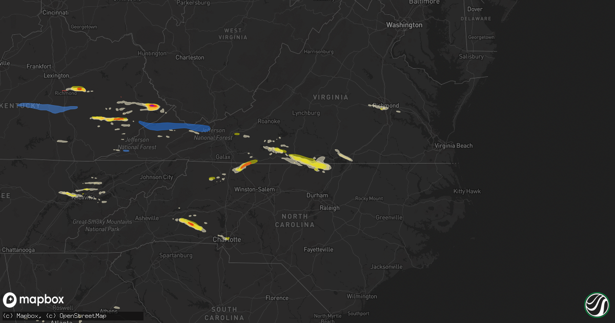
Hail Map on May 16, 2023
Get this storm
May 16 map
$229
one time, instant access
Download today. No call, no setup
Keep the $229
Bought the map and want the full workflow? Apply the entire $229 to a subscription within 7 days. None of it is wasted.
Every map, not just this one
This buys you this map. Subscription and you get every map we run, in the markets you choose from a few cities to whole states to nationwide. Plus real-time alerts the moment a storm fires.
Contact data
Name, contact info, occupancy, even credit band for addresses in the footprint. You go from where it hit to who to call.
Become the source they trust
Unlimited branding weather history reports on demand. You already have the documented answer ready for the property owner, and you are the one who showed up with it.
Property data and RoofTrace estimates
Pull up any address you have got, its value and the exact code rules for that jurisdiction, straight from One Click Code. Then RoofTrace estimates the squares, pitch, and roof value, priced the way you price.
States Impacted by Hail Map on May 16, 2023
Storm reports
Kentucky
| Date | Description |
|---|---|
| 05/16/20234:18 PM CDT | Dept of highways reported tree down in the town of majestic. Time estimated from radar. |
| 05/16/20234:15 PM CDT | Dept of highways reported a tree down in the town of freeburn. Time estimated from radar. |
| 05/16/20234:15 PM CDT | A tree was blown down onto old us 119 at partridge. The time of the event is radar estimated. |
| 05/16/20234:13 PM CDT | Pike county em referred to dispatch for reports of trees down in southern pike county. Time estimated from radar. |
| 05/16/20234:10 PM CDT | Video provided to pike county em showed golf ball size hail. Time estimated from radar. |
| 05/16/20234:09 PM CDT | Report forwarded via twitter off of lawsons branch near highway 194. |
| 05/16/20234:09 PM CDT | A tree was reported down near 1106 ky highway 568 near cranks. The event time is radar estimated. |
| 05/16/20234:08 PM CDT | A tree was reported to have been blown down on ky hwy 302 between on half mile and one mile before dewey dam. |
| 05/16/20234:05 PM CDT | Report from mping: large limbs were blown down. |
| 05/16/20234:05 PM CDT | A tree was reported to have been blown down onto ky hwy 805 near big shelby creek road. |
| 05/16/20234:05 PM CDT | A tree was blown down onto ky highway 805 about 1 to 2 miles from the pike county line. The time of the event is radar estimated. |
| 05/16/20234:02 PM CDT | A tree was reported to have been blown down onto ky hwy 987 near martins fork lake. The time of the event is radar estimated. |
| 05/16/20234:02 PM CDT | A tree was reported to have been blown down onto ky 3001 near mountain oaks drive. The time of the event is radar estimated. |
| 05/16/20234:01 PM CDT | Report of video provided to pike county em. At least tennis ball size hail. Time estimated from radar. |
| 05/16/20234:00 PM CDT | A tree was blown down onto ky hwy 1556. The time of the event is radar estimated. |
| 05/16/20234:00 PM CDT | Several trees were reported to have bene blown down onto ky 3409 between jenkins and mcroberts. The time of the event is radar estimated. |
| 05/16/20234:00 PM CDT | A tree was downed onto ky hwy 3001 near the harlan country club. The time of the event is radar estimated. |
| 05/16/20233:58 PM CDT | A tree was reported to have been blown down in mcroberts. The time of the event is radar estimated. |
| 05/16/20233:55 PM CDT | A tree was reported to have been blown down on ky 1469 near the pike county line. The time of the event is radar estimated. |
| 05/16/20233:53 PM CDT | Owsley county state garage reported a tree down on ky-1768 about a half of a mile down from the intersection of ky-28 and ky-1768. |
| 05/16/20233:52 PM CDT | A tree was reported to have been downed along ky 522 near russell road. The time of the event is radar estimated. |
| 05/16/20233:42 PM CDT | Trees were reported to have been blown down on ky 1087. |
| 05/16/20233:42 PM CDT | Highway department reported a tree down on us 460 between mm 0 and 9. Time estimated from radar. |
| 05/16/20233:35 PM CDT | A local report indicates 1.00 inch wind near 1 SSW AMBURGEY |
| 05/16/20233:34 PM CDT | Tree down on kentucky highway 1809. Time estimated from radar. |
| 05/16/20233:25 PM CDT | Picture on social media show approximately golf-ball size hail south of fisty... Ky. Time estimated from radar. |
| 05/16/20233:23 PM CDT | A tree was reported down on ky hwy 777 near the kentucky hydrocarbon company plant. |
| 05/16/20233:20 PM CDT | Picture posted to social media shows approximately half dollar-sized hail at hazard animal shelter. Time estimated from radar. |
| 05/16/20233:10 PM CDT | Trees and large limbs were reported to have been blown down on marydell road near bush. |
| 05/16/20233:03 PM CDT | Tree down in gray along kentucky highway 233. Time estimated from radar. |
| 05/16/20233:00 PM CDT | Army corp. Of engineer employee relayed a picture of large hail that fell at buckhorn lake dam. |
| 05/16/20232:55 PM CDT | A couple of trees reported down on ky 746 near mile marker 5. Time estimated from radar. |
| 05/16/20232:52 PM CDT | A tree was reported to have been blown down in east bernstadt. The time of the event is radar estimated. |
| 05/16/20232:51 PM CDT | A tree was blown down on north laurel road just north of the london city limits. |
| 05/16/20232:49 PM CDT | 2 trees down along highway 30. Time estimated from radar. |
| 05/16/20232:45 PM CDT | Tree down near the 2000 block of old whitney road. Time estimated from radar. |
| 05/16/20232:45 PM CDT | Tree down along highway 30. Time estimated from radar. |
| 05/16/20232:32 PM CDT | Corrects previous tstm wnd dmg report from lewis creek. A tree was reported down on ky 3403 near the harlan county line in the vicinity of partridge. The time of the ev |
| 05/16/20232:29 PM CDT | A tree was reported down on ky 3403 near the harlan county line in the vicinity of partridge. The time of the event is radar estimated. |
| 05/16/20232:28 PM CDT | Powerline down on bourne avenue close to the intersection of murphy avenue. Time estimated from radar. |
| 05/16/20232:25 PM CDT | Tree down off of nelson valley road near the intersection of jeffries drive. Time estimated from radar. |
| 05/16/20232:24 PM CDT | Report of a tree down off of highway 1247 near the intersection of raleigh road. |
| 05/16/20232:24 PM CDT | Corrects previous tstm wnd dmg report from 2 s science hill. Report of a tree down on a powerline off of highway 1247 near the intersection of raleigh road. Time estima |
| 05/16/20232:15 PM CDT | Nickel to quarter-sized hail covering the ground. |
| 05/16/20232:13 PM CDT | Tree down on a powerline off of koa campground road. Time estimated from radar. |
| 05/16/20232:13 PM CDT | Tree down on red bird road near lake linville road. Time estimated from radar. |
| 05/16/20232:12 PM CDT | Multiple trees down at 1490 barnett road. Time estimated from radar. |
| 05/16/20232:12 PM CDT | Picture on social media shows hail up golf-ball size near vaughn mill. |
| 05/16/20232:11 PM CDT | Tree down along highway 1505 near the intersection of highway 1326. Time estimated from radar. |
| 05/16/20232:10 PM CDT | Tree down in broadhead along highway 1505. Time estimated from radar. |
| 05/16/20232:10 PM CDT | Tree down on a vehicle at 142 proffitt street. Time estimated from radar. |
| 05/16/20232:09 PM CDT | Tree down along highway 3245 about a half mile west of the u.s. 150 intersection. Time estimated from radar. |
| 05/16/20232:09 PM CDT | Large limb was blocking the intersection at liberty road and bull run road. The road department was dispatched to remove the limb. |
| 05/16/20232:07 PM CDT | Tree down on the 9000 block of kentucky 1247. |
| 05/16/20232:03 PM CDT | Tree down on river drive. |
| 05/16/20232:03 PM CDT | Rowan county dept. Of highway reported 5 trees down along ky-377 between mm 5 and mm 6. Time estimated from radar. |
| 05/16/20232:00 PM CDT | Tree down on the 9000 block of us 127. |
| 05/16/20231:59 PM CDT | Tree down on horton cutoff road. |
| 05/16/20231:57 PM CDT | Delayed report. Spotter said there was a tree down in college hill that shut his electricity off until roughly 12 hours later. Also... He had dime sized plus hail at hi |
| 05/16/20231:55 PM CDT | Tree and power line down on danville avenue between portman avenue and maxwell street. |
| 05/16/20231:53 PM CDT | Tree down on highway 698. |
| 05/16/20231:44 PM CDT | Tree down on southridge rd. |
| 05/16/20231:44 PM CDT | Tree down on the 10000 block of highway 78 west. |
| 05/16/20231:41 PM CDT | Received two reports of a tree down on red house road. |
| 05/16/20231:33 PM CDT | Trees down in the forkland area. |
| 05/16/20231:32 PM CDT | Dead tree came down on his driveway. Time estimated from radar. |
| 05/16/20231:22 PM CDT | A tree fell across 31 east near uno. |
| 05/16/20231:18 PM CDT | Tree down on a power line on tatum lane. |
| 05/16/20231:10 PM CDT | Trees down across from marion county public library. |
| 05/16/20231:10 PM CDT | Bath county highway garage reported numerous trees down along ky-11 between sharpsburg and bethel. |
| 05/16/202312:25 PM CDT | Delayed report: dispatch reported tree down on raider hallow rd. |
Mississippi
| Date | Description |
|---|---|
| 05/16/20232:23 PM CDT | Law enforcement reported several trees down near hwy 503. |
Montana
| Date | Description |
|---|---|
| 05/16/20235:43 AM CDT | Asos station kolf wolf point airport. |
Kansas
| Date | Description |
|---|---|
| 05/15/20238:45 PM CDT | Reported via social media. |
| 05/15/20238:37 PM CDT | Pea to quarter sized hail measured in st. Francis. Reported via social media. |
| 05/15/20238:37 PM CDT | A local report indicates 67 MPH wind near 1 S SAINT FRANCIS |
| 05/15/20238:32 PM CDT | A local report indicates 64 MPH wind near SAINT FRANCIS |
Nebraska
| Date | Description |
|---|---|
| 05/15/20238:03 PM CDT | A local report indicates 68 MPH wind near 6 NNE HAIGLER |
| 05/15/20237:59 PM CDT | A local report indicates 58 MPH wind near 6 NNE HAIGLER |
| 05/15/20237:12 PM CDT | A local report indicates 1.00 inch wind near 13 S LAMAR |
Alabama
| Date | Description |
|---|---|
| 05/16/20235:55 PM CDT | Power lines were blown down near the intersection of cr 58 and county line rd. Along the lauderdale-limestone county border. Specific time of event based on radar data. |
| 05/16/20235:55 PM CDT | Trees and power lines were blow down near the intersection of garrison rd. And targum rd. In hartselle... With reports relayed from ema and broadcast media. Specific ti |
| 05/16/20235:54 PM CDT | Limestone county ema director estimated a wind gust of at least 60 mph at this location. Specific time of event based on radar data. |
| 05/16/20235:43 PM CDT | A large pine tree was uprooted near the intersection of cr 52 and cr 89 to the northwest of anderson. Specific time of event based on radar data. |
| 05/16/20235:21 PM CDT | Section of roof blown off an outbuilding/barn-like structure. |
| 05/16/20234:37 PM CDT | Multiple reports of downed trees along highway 20 and highway 22 between phil campbell and russellville. Specific time of event based on radar data. |
| 05/16/20232:42 PM CDT | Trees down in numerous locations throughout talladega county. Roadways blocked in several locations. |
| 05/16/20232:40 PM CDT | Fences and awnings blown down along county road 36. Radar showed a microburst at this location. |
| 05/16/20231:33 PM CDT | Trees reported down in leeds. |
| 05/16/20231:22 PM CDT | Tree fell through the roof of a residence. No injuries reported. |
| 05/16/20231:18 PM CDT | Large oak trees uprooted in moody. |
| 05/15/20239:48 PM CDT | A metal roof was peeled off of a church at 22870 sandlin road. Trees were also knocked down in the area. Time estimated by radar associated with an apparent gust front. |
Virginia
| Date | Description |
|---|---|
| 05/16/20236:58 PM CDT | A few downed trees. |
| 05/16/20236:58 PM CDT | Several trees were blown down in multiple locations around the town of stuart. |
| 05/16/20236:54 PM CDT | Numerous trees were blown down near the intersection of jeb stuart highway and trot valley road. A nearby personal weather station recorded a 52 mph wind gust at the ti |
| 05/16/20236:51 PM CDT | One tree down on willie craig road. |
| 05/16/20236:47 PM CDT | Thunderstorm winds blew down about twenty trees along ringgold church road from the barker road intersection to the countryside drive intersection. |
| 05/16/20236:47 PM CDT | Large tree down on a roof of a house and another tree fell onto a large propane tank. |
| 05/16/20236:41 PM CDT | Thunderstorm winds blew down one tree onto forestdale drive. |
| 05/16/20236:33 PM CDT | Several trees were blown down in multiple locations around the community of meadows of dan. |
| 05/16/20236:30 PM CDT | The franklin county sheriffs department reported numerous trees down across the county... As well as many power outages. Many of the reports were received after 7:30 pm |
| 05/16/20236:24 PM CDT | Trees down on bethlehem church rd. And huckleberry ridge rd. |
| 05/16/20236:18 PM CDT | A local report indicates 1.25 inch wind near 4 SSW STUART |
| 05/16/20236:15 PM CDT | 15 inch diameter trees down at the intersect of meadowlark road and declaration lane. |
| 05/16/20235:55 PM CDT | Flag pole broken. Large limbs and three trees downed. Trampoline blown in neighbors tree 500 yards away. |
| 05/16/20235:46 PM CDT | One tree down on figsboro road. |
| 05/16/20235:45 PM CDT | Large tree down. |
| 05/16/20235:43 PM CDT | Large tree down. |
| 05/16/20235:42 PM CDT | Large tree fell on house. |
| 05/16/20235:35 PM CDT | Couple of large trees down along allison gap road. |
| 05/16/20235:32 PM CDT | Tree down on rufus road. |
| 05/16/20235:30 PM CDT | Couple of large trees down along route 107 in saltville. |
| 05/16/20235:03 PM CDT | One tree down across earls branch road. |
| 05/16/20235:00 PM CDT | Several trees down across the county. |
| 05/16/20234:50 PM CDT | Multiple trees down. |
| 05/16/20234:50 PM CDT | One tree was blown down in red ash. |
| 05/16/20234:49 PM CDT | Tree down on a vehicle in a driveway along pat field road in haysi. |
| 05/16/20234:45 PM CDT | Tree down along old stone drive. Tree has fallen on a house and its huge. |
| 05/16/20234:40 PM CDT | *** 1 fatal *** tree fell onto an occupied vehicle on welcome lane. |
| 05/16/20234:40 PM CDT | Tree down and water line busted. |
| 05/16/20234:38 PM CDT | Tree down along robinson fork road in the area of garden creek. |
| 05/16/20234:33 PM CDT | Thunderstorm winds blew down one tree on to a power line along westover drive. |
| 05/16/20234:33 PM CDT | Tree down along gc powers drive. |
| 05/16/20234:30 PM CDT | Trees down. |
| 05/16/20234:25 PM CDT | Trees and power lines down on doe branch. |
| 05/16/20234:25 PM CDT | Multiple trees down. |
| 05/16/20234:24 PM CDT | Trees down along bartlick road and little rockhouse road. |
| 05/16/20234:24 PM CDT | Trees down all over vicey mountain road and 4 trees down on a house. |
| 05/16/20234:23 PM CDT | Tree down at 212 dc truck stop road in clincho. |
| 05/16/20234:22 PM CDT | Tree down along the lake road and dwale lane in clintwood. |
| 05/16/20234:22 PM CDT | Tree down along newberry ridge and big ridge road. |
| 05/16/20234:19 PM CDT | Tree down along centennial heights road. |
| 05/16/20234:17 PM CDT | Tree down on dc truck stop road. |
| 05/16/20234:16 PM CDT | Tree down on miami lane in clintwood. |
| 05/16/20234:15 PM CDT | Trees down. |
| 05/16/20234:14 PM CDT | Tree down along the lake road and marina cv. |
| 05/16/20234:08 PM CDT | Multiple trees down in ringgold area... Including ringgold depot rd.... Oliver dr.... And gunn garland rd. |
| 05/16/20233:56 PM CDT | Two trees snapped by thunderstorm winds near the intersection of peppers ferry road and va route 613. |
| 05/16/20233:51 PM CDT | Tree down on house on waller lane. |
| 05/16/20233:41 PM CDT | Tree down on dillions fork road... Near the ramp to u.s. Highway 220. |
| 05/16/20233:27 PM CDT | Reported by citizen on mt. Vernon road. |
| 05/16/20233:14 PM CDT | Thunderstorm winds blew down a tree on rockwood park road right before hickory hill drive. |
| 05/16/20232:52 PM CDT | Two trees down around the intersection of route 623 and banks ridge road. |
| 05/15/20239:57 PM CDT | Sky line road impassible due to water on roadway. |
| 05/15/20239:10 PM CDT | Large tree limbs downed in meadowville/mount blanco. Time is radar estimated. |
| 05/15/20239:03 PM CDT | Tree knocked down along monguy rd. Time estimated from radar. |
| 05/15/20238:37 PM CDT | Tree knocked down along middlefield ct. Time estimated from radar. |
| 05/15/20238:35 PM CDT | Trees and powerpoles knocked down along avignon drive. Time estimated from radar. |
| 05/15/20238:35 PM CDT | One inch hail reported in north chesterfield. Time estimated from radar. |
| 05/15/20238:29 PM CDT | Tree knocked down trottinridge rd. Time estimated from radar. |
| 05/15/20238:29 PM CDT | Tree knocked down on powerline. Time estimated from radar. |
| 05/15/20238:29 PM CDT | Tree knocked down on powerline. Time estimated from radar. |
| 05/15/20238:10 PM CDT | A large tree was blown down by thunderstorm winds near the intersection of shady grove church road and virgilina road. |
| 05/15/20238:03 PM CDT | A large tree was blown down by thunderstorm winds near the intersection of denniston road and paradise road. |
| 05/15/20238:03 PM CDT | Multiple trees were blown down along the 2000 block of paradise road. One of the trees was blown down across power lines... Resulting in power outages. |
| 05/15/20237:45 PM CDT | A large tree was blown down across chatham road. |
| 05/15/20237:25 PM CDT | Thunderstorm winds blew down three trees near the intersection of izaak walton road and blue ridge drive. |
| 05/15/20237:06 PM CDT | One tree down on chatham road. |
| 05/15/20237:02 PM CDT | Flag pole mounted in ground broken. |
| 05/15/20237:00 PM CDT | Numerous trees were reported down around the bassett area of henry county. |
Tennessee
| Date | Description |
|---|---|
| 05/16/20236:40 PM CDT | Corrects previous tstm wnd dmg report from 3 nw embreeville. A few trees down. |
| 05/16/20236:25 PM CDT | Several trees down. |
| 05/16/20236:25 PM CDT | Corrects previous tstm wnd dmg report from 4 nw embreeville. A few trees down. |
| 05/16/20236:10 PM CDT | Trees down across roadway. |
| 05/16/20236:03 PM CDT | Multiple trees down. |
| 05/16/20235:54 PM CDT | Broadcast media relayed viewer report of a tree blown down. Specific location and time of event were based on radar data. |
| 05/16/20235:50 PM CDT | Few trees and power lines down. |
| 05/16/20235:45 PM CDT | A few trees down. |
| 05/16/20235:40 PM CDT | Few trees down. |
| 05/16/20235:35 PM CDT | Few trees down. |
| 05/16/20235:35 PM CDT | Multiple trees down. |
| 05/16/20235:15 PM CDT | Report from mping: 3-inch tree limbs broken; power poles broken. |
| 05/16/20235:15 PM CDT | Tree dewon in rutledge. |
| 05/16/20234:45 PM CDT | Numerous trees down. |
| 05/16/20234:35 PM CDT | Trees down. |
| 05/16/20234:30 PM CDT | A local report indicates 1.00 inch wind near 3 NNE KNOXVILLE |
| 05/16/20234:01 PM CDT | Roof damage to barn and trees down. Time estimated from radar. |
| 05/16/20234:00 PM CDT | 3 trees down. One tree on top of car. |
| 05/16/20233:28 PM CDT | Social media picture of quarter size hail. Exact location in oak ridge not provided. |
| 05/16/20233:25 PM CDT | A local report indicates 1.00 inch wind near 5 SW CLINTON |
| 05/16/20233:20 PM CDT | Trees and large tree limbs down in and near seven oaks subdivision. |
| 05/16/20233:03 PM CDT | 1 inch hail in corryton... Tn. Time estimated from radar. |
| 05/16/20232:50 PM CDT | Report from mping: quarter |
Oregon
| Date | Description |
|---|---|
| 05/16/20236:25 PM CDT | Via social media. A few quarter size hail stones shown in a photo. |
| 05/16/20234:15 PM CDT | Hail covered the ground south of the city. Mostly small hail pea to dime but there were a few quarter size hail stones. |
Texas
| Date | Description |
|---|---|
| 05/16/20236:01 PM CDT | Bush intercontinental asos station reported 58 mph wind gust. |
| 05/16/20233:16 PM CDT | Large tree limb downed. |
South Carolina
| Date | Description |
|---|---|
| 05/16/20235:40 PM CDT | A fallen tree reported at the intersection of bent tree drive and friendship road. |
| 05/16/20235:39 PM CDT | A fallen tree was reported at the intersection of campbell bridge road and wild fern road. |
| 05/16/20234:20 PM CDT | Trees down at intersection of dixon rd and thaxton place ct |
| 05/16/20233:40 PM CDT | Corrects time of previous tstm wnd dmg report from 3 sse seneca. A fallen tree reported at the intersection of bent tree drive and friendship road. |
| 05/16/20233:39 PM CDT | Corrects time of previous tstm wnd dmg report from 3 s seneca. A fallen tree was reported at the intersection of campbell bridge road and wild fern road. |
| 05/15/20239:20 PM CDT | Trees down along townsend dr. |
North Carolina
| Date | Description |
|---|---|
| 05/16/20236:58 PM CDT | Quarter size hail in uptown charlotte |
| 05/16/20236:45 PM CDT | 1 tree down on deerfield run. |
| 05/16/20236:35 PM CDT | 2 small trees were blown down as the storm crossed mitchell county. |
| 05/16/20236:30 PM CDT | 1 tree down on aurelian springs rd near hwy 48. |
| 05/16/20236:15 PM CDT | 1 tree down at us-15 and knotts grove rd. |
| 05/16/20236:10 PM CDT | A local report indicates 1.25 inch wind near 3 NNE WOODVILLE |
| 05/16/20236:06 PM CDT | Thunderstorm winds blew down a tree on sawyer road. Report from social media. |
| 05/16/20236:05 PM CDT | Tree down near cook school road. |
| 05/16/20236:04 PM CDT | Tree down near intersection of cook school road and howell road. |
| 05/16/20236:02 PM CDT | Thunderstorm winds blew down a tree on harrold mountain road. Report from social media. |
| 05/16/20235:50 PM CDT | 1 tree down on macon-embro rd. |
| 05/16/20235:42 PM CDT | A local report indicates 1.00 inch wind near FALLSTON |
| 05/16/20235:40 PM CDT | Numerous trees and powerlines down in cherryville...especially the northeast side...including roy eaker rd...n cherry st |
| 05/16/20235:40 PM CDT | Numerous trees and powerlines down in cherryville...especially the northeast side...including roy eaker rd...n cherry st...hwy 150. |
| 05/16/20235:25 PM CDT | Mping user reported half dollar size hail |
| 05/16/20235:12 PM CDT | Power outage due to fallen trees on utility equipment. |
| 05/16/20235:05 PM CDT | Reports of the tops of 9 trees damaged. |
| 05/16/20235:04 PM CDT | Quarter size hail reported in casar. |
| 05/16/20235:04 PM CDT | Golf ball sized hail reported in casar... Nc. |
| 05/16/20235:01 PM CDT | Thunderstorm winds blew down a tree on route 119 in semora. |
| 05/16/20234:48 PM CDT | Power outage due to fallen trees on utility equipment. |
| 05/16/20234:18 PM CDT | Tree and power lines down in 5300 block of vein mtn rd. |
| 05/15/202311:40 PM CDT | 2 trees down in road. |
| 05/15/202311:10 PM CDT | Corrects previous tstm wnd dmg report from 3 nnw flowers. Tree fell on unoccupied house. |
| 05/15/202310:55 PM CDT | Tress down around scotland neck area. |
| 05/15/202310:34 PM CDT | One tree was reported down near the intersection of house road and flower hill road. |
| 05/15/202310:30 PM CDT | Tree and debri reported down near robbins... Nc. |
| 05/15/202310:25 PM CDT | Tree fell on unoccupied house. |
| 05/15/202310:20 PM CDT | One tree was reported down near the intersection of archer lodge road and buffalo road. |
| 05/15/202310:17 PM CDT | A tree was reported down in the road near the intersection of medlin road windless trail. |
| 05/15/202310:12 PM CDT | Multiple downed trees caused power outages southeast of walnut creek. |
| 05/15/20239:47 PM CDT | Tree downed along jefferson ave/us-158 in jackson. |
| 05/15/20239:23 PM CDT | 1 tree down at wayman church rd and justice branch rd. |
| 05/15/20239:00 PM CDT | Trees down along dunn commons parkway. |
| 05/15/20238:50 PM CDT | Tree down on mobile home on freshwater rd. |
| 05/15/20238:46 PM CDT | 1 tree down at rogers rd and southern high mt hermon rd. |
| 05/15/20238:45 PM CDT | 1 tree was blown down on belmont-mt herman road. Time estimated by radar. |
| 05/15/20238:38 PM CDT | 1 tree down on bellemont alamance rd. |
| 05/15/20238:37 PM CDT | Corrects previous tstm wnd dmg report from 1 nne stovall. Trees were reported down on power lines along us highway 15... Just north of puckett street. |
| 05/15/20238:14 PM CDT | Liberty road is closed in both directions due to a single-vehicle crash involving a downed tree and damaged utility equipment. |
| 05/15/20238:12 PM CDT | Tree reported down at intersection of pinecroft road and vanstory street. |
| 05/15/20238:06 PM CDT | Multiple downed trees caused power outages near john kerr resevoir. |
| 05/15/20238:00 PM CDT | One tree down along tunnel rd. |
| 05/15/20238:00 PM CDT | Multiple downed trees caused power outages near the piedmont triad international airport. |
| 05/15/20237:59 PM CDT | Trees were reported down on power lines along us highway 15... Just north of puckett street. |
| 05/15/20237:55 PM CDT | Trees uprooted or snapped; roof blown off. |
| 05/15/20237:50 PM CDT | A tree fell on a power line. |
| 05/15/20237:50 PM CDT | Tree down along captains drive. |
| 05/15/20237:43 PM CDT | Numerous trees reported down throughout forsyth county. |
| 05/15/20237:30 PM CDT | Tree down. Exact location unknown. |
| 05/15/20237:30 PM CDT | Trees down along leicester hwy. |
| 05/15/20237:23 PM CDT | Multiple trees reported down north of roxboro... Nc near bethel hill school rd and hwy 501n. |
| 05/15/20237:22 PM CDT | Large hail reported north of roxboro... Nc near bethel hill school rd and hwy 501n. |
| 05/15/20237:12 PM CDT | Chimney blown off house. |
| 05/15/20237:12 PM CDT | Several trees were blown down in multiple locations across the town of yadkinville. A power pole was blown down onto a home. In addition... A shed was blown over and de |
| 05/15/20237:12 PM CDT | Multiple downed trees caused power outages near hyco lake. |
| 05/15/20237:10 PM CDT | *** 1 inj *** numerous trees and power lines were blown down in multiple locations around the community of boonville. A least one tree was blown down onto a home and an |
| 05/15/20237:10 PM CDT | A tree fell across a road temporarily blocking traffic. Small hail mainly pea sized also was reported in this area. |
| 05/15/20237:04 PM CDT | Report of multiple trees down near the intersection of cc camp road and friendship church road. |
| 05/15/20237:02 PM CDT | 1 inch hail reported near hays... Nc. |
| 05/15/20237:02 PM CDT | 1 in. Hail reported near hays... Nc. |
West Virginia
| Date | Description |
|---|---|
| 05/16/20235:22 PM CDT | Tree down on stewart street. |
| 05/16/20235:13 PM CDT | Tree in the road along rocket boys drive. |
| 05/16/20235:05 PM CDT | Tree down blocking most of the road. |
Georgia
| Date | Description |
|---|---|
| 05/16/20235:20 PM CDT | Power pole down at hawkins academy rd between knox chapel rd and simon solar farm. |
| 05/16/20234:53 PM CDT | Multiple trees and powerlines down including along twin lakes rd at tom brewer road... Bay creek rd near golden isles dr... Hwy 81 at bay creek church rd... Tiffany ln |
| 05/16/20234:51 PM CDT | Powerline down along sandy creek rd between sandy creek cir and sandy creek ct. |
| 05/16/20234:51 PM CDT | Tree down on winding grove ln near southern cul de sac. |
| 05/16/20233:48 PM CDT | Tree down along hwy 78 in the town of waco. |
| 05/16/20233:37 PM CDT | Tree down along macedonia church rd. |
Cities Impacted by Hail Map on May 16, 2023
- Lebanon, KY
- Bradfordsville, KY
- Gravel Switch, KY
- Parksville, KY
- Hustonville, KY
- Junction City, KY
- Stanford, KY
- Richmond, KY
- Waco, KY
- Irvine, KY
- Clay City, KY
- Winchester, KY
- Waynesburg, KY
- Crab Orchard, KY
- Lancaster, KY
- Mount Vernon, KY
- Brodhead, KY
- Berea, KY
- McKee, KY
- Orlando, KY
- Manchester, KY
- Sextons Creek, KY
- Booneville, KY
- Sandgap, KY
- Oneida, KY
- Mistletoe, KY
- Buckhorn, KY
- Knoxville, TN
- Corryton, TN
- Bonnyman, KY
- Hazard, KY
- Bulan, KY
- Dwarf, KY
- Oak Ridge, TN
- Carrie, KY
- Jackhorn, KY
- Virgie, KY
- Jenkins, KY
- Neon, KY
- McRoberts, KY
- Deane, KY
- Shelby Gap, KY
- Clintwood, VA
- Pound, VA
- Clinchco, VA
- Haysi, VA
- Birchleaf, VA
- Bee, VA
- Dante, VA
- Vansant, VA
- Grundy, VA
- Davenport, VA
- Oakwood, VA
- Rowe, VA
- Morganton, NC
- Bostic, NC
- Raven, VA
- Jewell Ridge, VA
- Whitewood, VA
- Casar, NC
- Richlands, VA
- Bandy, VA
- Pennington Gap, VA
- Tazewell, VA
- North Tazewell, VA
- Cedar Bluff, VA
- Squire, WV
- Berwind, WV
- Roxboro, NC
- Cherryville, NC
- Lawndale, NC
- Vale, NC
- Bluefield, VA
- Bastian, VA
- Ceres, VA
- Rocky Gap, VA
- Martinsville, VA
- Callands, VA
- Millers Creek, NC
- McGrady, NC
- North Wilkesboro, NC
- Hays, NC
- Danville, VA
- Dry Fork, VA
- Blairs, VA
- Ringgold, VA
- Sutherlin, VA
- Keeling, VA
- Alton, VA
- South Boston, VA
- Semora, NC
- Virgilina, VA
- Oxford, NC
- Charlotte, NC
- Crouse, NC
- Axton, VA
- Chesterfield, VA
- Richmond, VA
- Dryden, VA
- Brogan, OR
- Vale, OR
- Harper, OR
- Baker City, OR
- Parks, NE
- Champion, NE
- Haigler, NE
- Saint Francis, KS
- Krypton, KY
- Busy, KY
- Hyden, KY
- Hindman, KY
- Pikeville, KY
- Raccoon, KY
- Kimper, KY
- Mount Airy, NC
- Ararat, NC
- Pilot Mountain, NC
- Westfield, NC
- Claudville, VA
- Stuart, VA
- Lawsonville, NC
- Radford, VA
- Dublin, VA
- Starkville, MS
- Sevierville, TN
- Poplarville, MS
- Ozark, AL
- Kalispell, MT
- Kila, MT
- Corbin, KY
- Parkers Lake, KY
- Akron, CO
- Clinton, TN
- Oliver Springs, TN
- Spring Branch, TX
- Bergheim, TX
- Kendalia, TX
- Union Springs, AL
- Midway, AL
- Batchelor, LA
- Adrian, TX
- Andalusia, AL
- Gantt, AL
- Opp, AL
- Forkland, AL
- Boligee, AL
- Titus, AL
- Watson, AR
- Baskerville, VA
- Bracey, VA
- Matagorda, TX
- Bay City, TX
- Imperial, NE
- Clayhole, KY
- Bay Minette, AL
- Union Mills, NC
- Bessemer City, NC
- Nebo, NC
- Ellenboro, NC
- Shelby, NC
- Troy, AL
- Banks, AL
- Jackson, KY
- Lewellen, NE
- York, AL
- Penhook, VA
- Chatham, VA
- Rocky Mount, VA
- Quitman, MS
- Jackson, AL
- Moundville, AL
- Marion, NC
- Pine Top, KY
- Germantown, TN
- Collierville, TN
- Bullock, NC
- Milton, NC
- Snellville, GA
- Grayson, GA
- Loganville, GA
- Cumberland, KY
- Leeds, AL
- Washburn, TN
- Sidney, NE
- Leoti, KS
- Rudyard, MT
- Talladega, AL
- Phyllis, KY
- Mississippi State, MS
- Geyser, MT
- Mantee, MS
- Shepherd, MT
- Pounding Mill, VA
- Adel, GA
- Rutledge, TN
- Meadows Of Dan, VA
- Florence, AL
- Killen, AL
- Livingston, AL
- Salyersville, KY
- Ivel, KY
- Gunlock, KY
- Grethel, KY
- McDowell, KY
- Printer, KY
- Pinsonfork, KY
- Tram, KY
- Banner, KY
- David, KY
- Teaberry, KY
- Martin, KY
- McAndrews, KY
- Harold, KY
- Langley, KY
- Dana, KY
- Betsy Layne, KY
- Prestonsburg, KY
- Stanville, KY
- Shelbiana, KY
- Newnan, GA
- Louin, MS
- Rose Hill, MS
- McIntosh, AL
- Palacios, TX
- Monroeville, AL
- Repton, AL
- Frisco City, AL
- Birmingham, AL
- Pelham, AL
- Helena, AL
- Oxford, AL
- Eastaboga, AL
- Anniston, AL
- West Blocton, AL
- Woodstock, AL
- Midland City, AL
- Batesville, MS
- Bessemer, AL
- Alabaster, AL
- Oakland, MS
- Coffeeville, MS
- Chavies, KY
- Vicco, KY
- Sassafras, KY
- Slidell, LA
- New Orleans, LA
- Henry, VA
- Collinsville, VA
- Bassett, VA
- Conyers, GA
- South Hill, VA
- Chase City, VA
- Boydton, VA
- Skipwith, VA
- Julesburg, CO
- Buchanan, GA
- Bremen, GA
- Macon, MS
- Weaver, AL
- Geneva, AL
- Lumpkin, GA
- Franklin, LA
- Bailey, MS
- Meridian, MS
- Maynardville, TN
- Powhatan, VA
- Midlothian, VA
- Villa Rica, GA
- Henrico, VA
- New Market, TN
- Luttrell, TN
- Blaine, TN
- Falkner, MS
- Ripley, MS
- Elba, AL
- Corpus Christi, TX
- Cottondale, FL
- Chipley, FL
- Graceville, FL
- Harlingen, TX
- Broadwater, NE
- Cascade, MT
- Brantley, AL
- Cantonment, FL
- Douglasville, GA
- Glade Hill, VA
- Lost Creek, KY
- Santa Fe, TX
- Dickinson, TX
- Union Hall, VA
- Enterprise, MS
- Stonewall, MS
- Swords Creek, VA
- Molino, FL
- Jefferson City, TN
- Dandridge, TN
- Tylertown, MS
- Wagarville, AL
- Sunflower, AL
- Mount Holly, NC
- Cedarbluff, MS
- Pheba, MS
- Cascade, VA
- Blanch, NC
- Providence, NC
- Ravenna, KY
- Stanton, KY
- Riner, VA
- Mobile, AL
- Pilot, VA
- Floyd, VA
- Campbellton, FL
- Burlington, CO
- Bethune, CO
- Colbert, GA
- Adkins, TX
- La Vernia, TX
- Santa Rosa, NM
- Stratton, CO
- Kirk, CO
- Seymour, TN
- Malta, MT
- Elkin, NC
- Patterson, LA
- Leavenworth, WA
- Dobson, NC
- Jamieson, OR
- Pineland, SC
- Fayetteville, TN
- State Road, NC
- Thurmond, NC
- Christiansburg, VA
- Florence, MS
- Sidney, KY
- Demopolis, AL
- Greensboro, AL
- Lexington, AL
- Greenwood, MS
- Cotulla, TX
- Hazlehurst, MS
- Dozier, AL
- Venango, NE
- Palmetto, GA
- Anderson, AL
- Cleveland, VA
- Honaker, VA
- Vance, AL
- Clanton, AL
- Cawood, KY
- Cranks, KY
- Ronda, NC
- Smilax, KY
- Viper, KY
- Ferrum, VA
- Vossburg, MS
- La Marque, TX
- League City, TX
- Texas City, TX
- Brooklyn, MS
- Hattiesburg, MS
- Traphill, NC
- Roaring River, NC
- Mascot, TN
- Ganado, TX
- Littcarr, KY
- Hornsby, TN
- Comer, GA
- Meigs, GA
- Ochlocknee, GA
- Big Rock, VA
- Hurley, VA
- Phelps, KY
- Sulphur, LA
- Vest, KY
- Holt, FL
- Jeremiah, KY
- Happy, KY
- Blackey, KY
- Redfox, KY
- Scuddy, KY
- Robertsdale, AL
- Wooton, KY
- Powell, TN
- Potter, NE
- Guntown, MS
- Denver, CO
- Detroit, AL
- Lisman, AL
- Jachin, AL
- Courtland, MS
- Wauconda, WA
- Lincolnton, NC
- Trussville, AL
- Connelly Springs, NC
- Hickory, NC
- Charles City, VA
- Akron, AL
- Samson, AL
- Seadrift, TX
- Newton, MS
- Pachuta, MS
- Huntley, MT
- Duncan, MS
- Hereford, TX
- Yuma, CO
- Slade, KY
- Heiskell, TN
- Strawberry Plains, TN
- Corinth, MS
- Glen, MS
- Nora, VA
- Steele, KY
- Fedscreek, KY
- Heflin, AL
- Newbern, AL
- Wilsonville, AL
- De Kalb, MS
- Lauderdale, MS
- Leburn, KY
- Mousie, KY