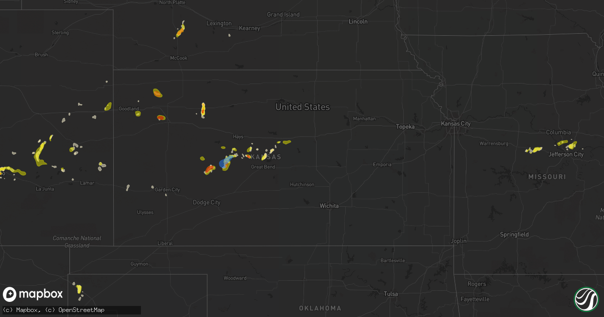
Hail Map in Kansas on May 16, 2021
Get this storm
May 16 map
$229
one time, instant access
Download today. No call, no setup
Keep the $229
Bought the map and want the full workflow? Apply the entire $229 to a subscription within 7 days. None of it is wasted.
Every map, not just this one
This buys you this map. Subscription and you get every map we run, in the markets you choose from a few cities to whole states to nationwide. Plus real-time alerts the moment a storm fires.
Contact data
Name, contact info, occupancy, even credit band for addresses in the footprint. You go from where it hit to who to call.
Become the source they trust
Unlimited branding weather history reports on demand. You already have the documented answer ready for the property owner, and you are the one who showed up with it.
Property data and RoofTrace estimates
Pull up any address you have got, its value and the exact code rules for that jurisdiction, straight from One Click Code. Then RoofTrace estimates the squares, pitch, and roof value, priced the way you price.
Storm reports in Kansas
Kansas
| Date | Description |
|---|---|
| 05/16/20216:52 PM CDT | A local report indicates 1.00 inch wind near 3 W OTIS |
| 05/16/20216:46 PM CDT | Relayed via social media. Image of golf ball size hail in the town of morland. Time estimated by radar. |
| 05/16/20216:20 PM CDT | Delayed report. Spotter reported quarter to half-dollar sized hail that lasted a duration of 25 minutes. Start time estimated by spotter and radar. |
| 05/16/20216:05 PM CDT | A local report indicates 1.00 inch wind near HOISINGTON |
| 05/16/20216:02 PM CDT | A local report indicates 1.25 inch wind near HOISINGTON |
| 05/16/20215:20 PM CDT | Spotter had 60 mph winds and dime size hail. |
| 05/16/20217:58 AM CDT | At 1258 AM CDT, a severe thunderstorm was located near Halstead, moving north at 20 mph. HAZARD...60 mph wind gusts and quarter size hail. SOURCE...Radar indicated. IMPACT...Hail damage to vehicles is expected. Expect wind damage to roofs, siding, and trees. Locations impacted include... Newton, North Newton, Walton, Hesston and Moundridge.This includes Interstate 135 between Mile Markers 27 and 48. |
| 05/16/20217:14 AM CDT | At 1214 AM CDT, a severe thunderstorm was located near Maize, moving north at 15 mph. HAZARD...60 mph wind gusts and quarter size hail. SOURCE...Radar indicated. IMPACT...Hail damage to vehicles is expected. Expect wind damage to roofs, siding, and trees. Locations impacted include... Bentley, Sedgwick, Halstead and Newton.This includes Interstate 135 between Mile Markers 12 and 30. |
| 05/16/20214:34 AM CDT | At 934 PM CDT, a severe thunderstorm was located 13 miles north of Colby, moving south at 10 mph. HAZARD...Quarter size hail. SOURCE...Radar indicated. IMPACT...Damage to vehicles is expected. This severe thunderstorm will remain over mainly rural areas of north central Thomas and south central Rawlins Counties. |
| 05/16/20212:52 AM CDT | At 751 PM CDT, a severe thunderstorm was located very near Alexander, moving southwest at 10 mph. HAZARD...70 mph wind gusts and quarter size hail. SOURCE...Radar indicated. IMPACT...Hail damage to vehicles is expected. Expect considerable tree damage. Wind damage is also likely to mobile homes, roofs, and outbuildings. Locations impacted include... Bazine. |
| 05/16/20212:27 AM CDT | At 727 PM CDT, a severe thunderstorm was located very near Hargrave, moving south at 5 mph. HAZARD...Half dollar size hail. SOURCE...Radar indicated. IMPACT...Damage to vehicles is expected. Locations impacted include... Alexander and Nekoma. |
| 05/16/20211:49 AM CDT | At 649 PM CDT, a severe thunderstorm was located over Morland, or 13 miles west of Hill City, moving south at 10 mph. HAZARD...60 mph wind gusts and half dollar size hail. SOURCE...Radar indicated. IMPACT...Hail damage to vehicles is expected. Expect wind damage to roofs, siding, and trees. This severe thunderstorm will remain over mainly rural areas of southeastern Sheridan and southwestern Graham Counties, including the following locations... Saint Peter, Studley and Penokee. |
| 05/16/20211:35 AM CDT | At 634 PM CDT, a severe thunderstorm was located near Liebenthal, and is nearly stationary. Another severe thunderstorm was located 5 miles north of McCracken and was also nearly stationary. HAZARD...60 mph wind gusts and half dollar size hail. SOURCE...Radar indicated. IMPACT...Hail damage to vehicles is expected. Expect wind damage to roofs, siding, and trees. Locations impacted include... Schoenchen and Liebenthal. |
| 05/16/20211:24 AM CDT | At 624 PM CDT, a severe thunderstorm was located near Pfeifer, moving southwest at 15 mph. HAZARD...Ping pong ball size hail and 60 mph wind gusts. SOURCE...Radar indicated. IMPACT...People and animals outdoors will be injured. Expect hail damage to roofs, siding, windows, and vehicles. Expect wind damage to roofs, siding, and trees. This severe thunderstorm will be near... Loretta around 640 PM CDT.Other locations in the path of this severe thunderstorm include Otisand Bison. |
| 05/16/20211:04 AM CDT | At 603 PM CDT, a severe thunderstorm was located over Hoisington, moving southwest at 15 mph. HAZARD...60 mph wind gusts and half dollar size hail. SOURCE...Trained weather spotters. IMPACT...Hail damage to vehicles is expected. Expect wind damage to roofs, siding, and trees. Locations impacted include... Great Bend and Albert. |
| 05/16/202112:25 AM CDT | Awos station kuls ulysses. |
| 05/16/202112:12 AM CDT | At 512 PM CDT, a severe thunderstorm was located 7 miles northwest of Claflin, moving southwest at 15 mph. HAZARD...60 mph wind gusts and half dollar size hail. SOURCE...Radar indicated. IMPACT...Hail damage to vehicles is expected. Expect wind damage to roofs, siding, and trees. This severe thunderstorm will be near... Claflin around 525 PM CDT.Other locations in the path of this severe thunderstorm includeHoisington. |
| 05/15/202110:10 PM CDT | At 310 PM CDT, a severe thunderstorm was located over Ellsworth, and is nearly stationary. HAZARD...60 mph wind gusts and quarter size hail. SOURCE...Radar indicated. IMPACT...Hail damage to vehicles is expected. Expect wind damage to roofs, siding, and trees. Locations impacted include... Kanopolis. |
| 05/15/20218:32 PM CDT | At 131 PM CDT, a severe thunderstorm was located 5 miles northeast of Emporia, moving northeast at 10 mph. HAZARD...60 mph wind gusts and quarter size hail. SOURCE...Radar indicated. IMPACT...Hail damage to vehicles is expected. Expect wind damage to roofs, siding, and trees. Locations impacted include... Reading. |
| 05/15/20218:08 PM CDT | Large tree down. |
| 05/15/20217:45 PM CDT | Reports of 60-70 mph wind gusts. |
All States Impacted by Hail Map on May 16, 2021
Cities Impacted by Hail Map on May 16, 2021
- Garden City, KS
- Earth, TX
- Nocona, TX
- Ryan, OK
- Wilson, OK
- Ringling, OK
- Saint Jo, TX
- Westbrook, TX
- Crowell, TX
- Quanah, TX
- Vernon, TX
- Seymour, TX
- Dalhart, TX
- Ballwin, MO
- Maywood, NE
- Clarendon, TX
- Rotan, TX
- McCaulley, TX
- Roby, TX
- Hamlin, TX
- Canyon, TX
- Claude, TX
- Poolville, TX
- Weatherford, TX
- O'Brien, TX
- Crosbyton, TX
- Walsenburg, CO
- Girard, TX
- Colorado City, TX
- Bridgeport, TX
- Lakeview, TX
- Snyder, TX
- Pueblo, CO
- Sudan, TX
- Petersburg, TX
- Floydada, TX
- Loomis, NE
- Deerfield, KS
- Hugo, CO
- Bellevue, TX
- Henrietta, TX
- Childress, TX
- Karval, CO
- Vega, TX
- Hereford, TX
- Morland, KS
- Texline, TX
- Edson, KS
- Haswell, CO
- La Veta, CO
- Marietta, OK
- Whitesboro, TX
- Loraine, TX
- Knox City, TX
- Atwood, KS
- Otterville, MO
- Tipton, MO
- Clarksburg, MO
- Florence, MO
- Syracuse, MO
- Wayside, TX
- Chillicothe, TX
- Paducah, TX
- Plainview, TX
- Roscoe, TX
- Sweetwater, TX
- Great Bend, KS
- Hoisington, KS
- Orland, ME
- Lorenzo, TX
- Smithton, MO
- McClave, CO
- Amarillo, TX
- Chico, TX
- Perrin, TX
- Jacksboro, TX
- Bowie, TX
- Alvord, TX
- Goree, TX
- Weinert, TX
- Munday, TX
- Rochester, TX
- Garden City, TX
- Big Lake, TX
- Ordway, CO
- Ogden, UT
- Eads, CO
- Rawlins, WY
- Ballinger, TX
- Lockney, TX
- Penokee, KS
- Hermleigh, TX
- Ulysses, KS
- Claflin, KS
- Sheridan Lake, CO
- Silverton, TX
- Meade, KS
- Wray, CO
- Willard, UT
- Ness City, KS
- Bazine, KS
- La Crosse, KS
- Alexander, KS
- Sugar City, CO
- Bison, KS
- Boone, CO
- Terral, OK
- Cee Vee, TX
- Springtown, TX
- Jayton, TX
- Otis, KS
- Sunset, TX
- Arlington, CO
- Aspermont, TX
- Abernathy, TX
- Hale Center, TX
- Surry, ME
- Matador, TX
- Ashland, MO
- Fieldton, TX
- Springlake, TX
- Kit Carson, CO
- Logan, UT
- Stratton, CO
- Colorado Springs, CO
- Yoder, CO
- Wildorado, TX
- Eureka, MO
- Flagler, CO
- Pacific, MO
- House Springs, MO
- Syracuse, KS
- Mcadoo, TX
- Happy, TX
- New Bloomfield, MO
- Avondale, CO
- Ira, TX
- Burlington, CO
- Branson, CO
- Idalou, TX
- Ralls, TX
- Dickens, TX
- Spur, TX
- Flomot, TX
- Roaring Springs, TX
- Quitaque, TX
- Hartsburg, MO
- Curtis, NE
- Bethune, CO
- Sabine Pass, TX
- Port Arthur, TX
- Overton, NE
- Elm Creek, NE
- Bertrand, NE
- Starks, LA
- Eden, UT
- Ingalls, KS
- Ringgold, TX
- Chesterfield, IL
- Fulton, MO
- Seibert, CO
- Hoxie, KS
- Tebbetts, MO
- Wilson, KS
- Rule, TX
- Old Glory, TX
- Azle, TX
- Memphis, TX
- McCracken, KS
- Skellytown, TX
- Chamois, MO
- Carlinville, IL
- Strawn, TX
- Mingus, TX
- Grenville, NM
- Monument, KS
- Paradise, TX
- Holts Summit, MO
- Hanston, KS
- Tell, TX
- Big Spring, TX
- Sterling City, TX
- Jamestown, MO
- Centertown, MO
- Overbrook, OK
- Plainville, KS
- Hayes Center, NE
- Mokane, MO
- Coahoma, TX
- Afton, TX
- Cimarron, KS
- Model, CO
- Fowler, CO
- Gorham, KS
- Pierceville, KS
- Wheeler, IL
- Montrose, IL
- Wichita Falls, TX
- Rio Hondo, TX
- Bunceton, MO
- Ellsworth, KS
- Colby, KS
- Brownell, KS
- Burdett, KS
- Beeler, KS
- Jetmore, KS
- Olney Springs, CO
- West Jordan, UT
- Herriman, UT
- Bingham Canyon, UT
- Magna, UT
- South Jordan, UT
- Tooele, UT
- Leon, OK
- Burneyville, OK
- Ardmore, OK
- Masterson, TX
- Panhandle, TX
- McCamey, TX
- Olton, TX
- White Deer, TX
- Tulia, TX
- Stamford, TX
- Fort Worth, TX
- Healdton, OK
- Gordonville, TX
- Sadler, TX
- Gainesville, TX
- Pottsboro, TX
- Muenster, TX
- Thackerville, OK
- Kress, TX
- Turkey, TX
- Dallas, TX


