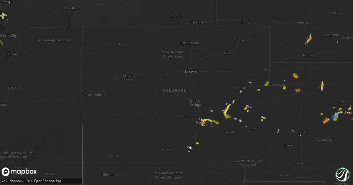
Hail Map in Colorado on May 16, 2021
Get this storm
May 16 map
$229
one time, instant access
Download today. No call, no setup
Keep the $229
Bought the map and want the full workflow? Apply the entire $229 to a subscription within 7 days. None of it is wasted.
Every map, not just this one
This buys you this map. Subscription and you get every map we run, in the markets you choose from a few cities to whole states to nationwide. Plus real-time alerts the moment a storm fires.
Contact data
Name, contact info, occupancy, even credit band for addresses in the footprint. You go from where it hit to who to call.
Become the source they trust
Unlimited branding weather history reports on demand. You already have the documented answer ready for the property owner, and you are the one who showed up with it.
Property data and RoofTrace estimates
Pull up any address you have got, its value and the exact code rules for that jurisdiction, straight from One Click Code. Then RoofTrace estimates the squares, pitch, and roof value, priced the way you price.
Storm reports in Colorado
Colorado
| Date | Description |
|---|---|
| 05/16/20216:21 PM CDT | Report from mping: quarter |
| 05/16/20216:09 PM CDT | A local report indicates 1.25 inch wind near 4 NE BLENDE |
| 05/16/20215:54 PM CDT | A local report indicates 1.00 inch wind near 4 NE BLENDE |
| 05/16/20215:46 PM CDT | A local report indicates 1.25 inch wind near 5 ENE BLENDE |
| 05/16/20215:46 PM CDT | Report from mping: quarter |
| 05/16/20215:42 PM CDT | A local report indicates 1.75 inch wind near 3 E BLENDE |
| 05/16/20215:42 PM CDT | A local report indicates 2.00 inch wind near 3 E BLENDE |
| 05/16/20215:40 PM CDT | Measured after hail stopped. Time estimated by radar. |
| 05/16/20215:36 PM CDT | Hail covering the ground. |
| 05/16/20215:35 PM CDT | A local report indicates 1.00 inch wind near 2 E PUEBLO |
| 05/16/20215:31 PM CDT | Delayed report. Cocorahs station co-ln-34 karval 4.8 w. Observer noted dented cars and damaged shingles. Time estimated by radar. |
| 05/16/20215:30 PM CDT | A local report indicates 1.75 inch wind near 2 ENE PUEBLO |
| 05/16/20215:25 PM CDT | A local report indicates 1.75 inch wind near 2 NE PUEBLO |
| 05/16/20215:23 PM CDT | University park neighborhood. |
| 05/16/20215:15 PM CDT | Corrects previous tornado report from 19 nnw ordway. Lifted at 419 pm. |
| 05/16/20214:52 PM CDT | A local report indicates 1.00 inch wind near WALSENBURG |
| 05/16/20214:50 PM CDT | A local report indicates 1.50 inch wind near LA VETA |
| 05/16/20217:15 AM CDT | Third hand report via emergency manager. Time estimated according to radar although two different storms did move over area within an hour. Chose first storm based on a |
| 05/16/20212:16 AM CDT | At 716 PM MDT, a severe thunderstorm was located 7 miles south of Bethune, or 10 miles southeast of Stratton, moving southeast at 5 mph. HAZARD...Half dollar size hail. SOURCE...Radar indicated. IMPACT...Damage to vehicles is expected. This severe thunderstorm will remain over mainly rural areas of southeastern Kit Carson County.This includes the following highways... Interstate 70 in Colorado between mile markers 427 and 431. Highway 385 between mile markers 173 and 181. |
| 05/16/20212:10 AM CDT | At 709 PM MDT, severe thunderstorms were located along a line extending from 10 miles south of Towner to Bristol, moving east at 25 mph. HAZARD...60 mph wind gusts and half dollar size hail. SOURCE...Radar indicated. IMPACT...Hail damage to vehicles is expected. Expect wind damage to roofs, siding, and trees. Locations impacted include... Holly, Granada, Hartman and Bristol. |
| 05/16/20211:59 AM CDT | At 659 PM MDT, severe thunderstorms were located along a line extending from Rocky Ford to Timpas, moving southeast at 25 mph. HAZARD...Ping pong ball size hail and 60 mph wind gusts. SOURCE...Radar indicated. IMPACT...People and animals outdoors will be injured. Expect hail damage to roofs, siding, windows, and vehicles. Expect wind damage to roofs, siding, and trees. Locations impacted include... La Junta, North La Junta, Rocky Ford, Swink, Higbee and Timpas. |
| 05/16/20211:43 AM CDT | At 643 PM MDT, severe thunderstorms were located along a line extending from 10 miles southeast of Sheridan Lake to near Queens Reservoir, moving east at 15 mph. HAZARD...60 mph wind gusts and quarter size hail. SOURCE...Radar indicated. IMPACT...Hail damage to vehicles is expected. Expect wind damage to roofs, siding, and trees. Locations impacted include... Wiley, Neeoshe Reservoir and Queens Reservoir. |
| 05/16/20211:40 AM CDT | At 639 PM MDT, a severe thunderstorm was located 4 miles northeast of Burlington, moving southwest at 5 mph. HAZARD...Half dollar size hail. SOURCE...Radar indicated. IMPACT...Damage to vehicles is expected. Locations impacted include... Burlington.This includes the following highways... Interstate 70 in Colorado between mile markers 435 and 447. Highway 385 between mile markers 179 and 198. |
| 05/16/20211:20 AM CDT | At 620 PM MDT, a severe thunderstorm was located 9 miles north of Fowler, or 29 miles east of Pueblo, moving southeast at 20 mph. HAZARD...Golf ball size hail and 60 mph wind gusts. SOURCE...Radar indicated. IMPACT...People and animals outdoors will be injured. Expect hail damage to roofs, siding, windows, and vehicles. Expect wind damage to roofs, siding, and trees. Locations impacted include... Rocky Ford, Fowler, Ordway, Manzanola, Olney Springs, Sugar City and Crowley. |
| 05/16/20211:10 AM CDT | At 609 PM MDT, a severe thunderstorm was located 10 miles south of Truckton, or 30 miles northeast of Pueblo, moving west at 10 mph. HAZARD...60 mph wind gusts and quarter size hail. SOURCE...Radar indicated. IMPACT...Hail damage to vehicles is expected. Expect wind damage to roofs, siding, and trees. This severe thunderstorm will remain over mainly rural areas of southeastern El Paso and northeastern Pueblo Counties. |
| 05/16/202112:58 AM CDT | At 558 PM MDT, severe thunderstorms were located along a line extending from 8 miles southwest of Flagler to 3 miles southeast of Stratton, and are nearly stationary. HAZARD...60 mph wind gusts and half dollar size hail. SOURCE...Radar indicated. IMPACT...Hail damage to vehicles is expected. Expect wind damage to roofs, siding, and trees. These severe thunderstorms will remain over mainly rural areas of northwestern Cheyenne and southwestern Kit Carson Counties in east central Colorado.This includes Interstate 70 in Colorado between mile markers 391 and424. |
| 05/16/202112:52 AM CDT | At 552 PM MDT, a severe thunderstorm was located over Boone, or 20 miles east of Pueblo, moving southeast at 15 mph. HAZARD...Ping pong ball size hail and 60 mph wind gusts. SOURCE...Radar indicated. IMPACT...People and animals outdoors will be injured. Expect hail damage to roofs, siding, windows, and vehicles. Expect wind damage to roofs, siding, and trees. Locations impacted include... Boone and Pueblo Depot. |
| 05/16/202112:44 AM CDT | At 544 PM MDT, a severe thunderstorm was located 7 miles south of Sheridan Lake, or 25 miles northeast of Lamar, and is nearly stationary. HAZARD...Ping pong ball size hail and 60 mph wind gusts. SOURCE...Radar indicated. IMPACT...People and animals outdoors will be injured. Expect hail damage to roofs, siding, windows, and vehicles. Expect wind damage to roofs, siding, and trees. Locations impacted include... Sheridan Lake and Brandon. |
| 05/16/202112:42 AM CDT | At 542 PM MDT, a severe thunderstorm was located 12 miles north of Sugar City, or 29 miles north of La Junta, moving southeast at 10 mph. HAZARD...60 mph wind gusts and quarter size hail. SOURCE...Radar indicated. IMPACT...Hail damage to vehicles is expected. Expect wind damage to roofs, siding, and trees. This severe thunderstorm will remain over mainly rural areas of northeastern Otero, southwestern Kiowa and northeastern Crowley Counties. |
| 05/16/202112:30 AM CDT | At 530 PM MDT, a severe thunderstorm was located 4 miles south of Kit Carson, or 26 miles west of Cheyenne Wells, and is nearly stationary. HAZARD...60 mph wind gusts and half dollar size hail. SOURCE...Radar indicated. IMPACT...Hail damage to vehicles is expected. Expect wind damage to roofs, siding, and trees. Locations impacted include... Kit Carson. |
| 05/16/202112:29 AM CDT | At 529 PM MDT, a severe thunderstorm was located over Pueblo Depot, or 16 miles east of Pueblo, moving east at 15 mph. HAZARD...60 mph wind gusts and quarter size hail. SOURCE...Radar indicated. IMPACT...Hail damage to vehicles is expected. Expect wind damage to roofs, siding, and trees. Locations impacted include... Pueblo Depot. |
| 05/16/202112:25 AM CDT | At 525 PM MDT, a severe thunderstorm was located near Flagler, and is nearly stationary. HAZARD...60 mph wind gusts and half dollar size hail. SOURCE...Radar indicated. IMPACT...Hail damage to vehicles is expected. Expect wind damage to roofs, siding, and trees. This severe thunderstorm will remain over mainly rural areas of southwestern Kit Carson County.This includes Interstate 70 in Colorado between mile markers 391 and405. |
| 05/16/202112:07 AM CDT | At 507 PM MDT, a severe thunderstorm was located near Pueblo West, or 12 miles northwest of Pueblo, moving northwest at 10 mph. HAZARD...60 mph wind gusts and quarter size hail. SOURCE...Radar indicated. IMPACT...Hail damage to vehicles is expected. Expect wind damage to roofs, siding, and trees. Locations impacted include... Pueblo West. |
| 05/15/202111:54 PM CDT | At 454 PM MDT, a severe thunderstorm was located 8 miles southwest of Boyero, or 31 miles southeast of Limon, and is nearly stationary. HAZARD...Half dollar size hail. SOURCE...Radar indicated. IMPACT...Damage to vehicles is expected. Locations impacted include... Boyero. |
| 05/15/202111:54 PM CDT | At 453 PM MDT, a severe thunderstorm was located 13 miles northeast of Des Moines, moving east at 10 mph. HAZARD...60 mph wind gusts and quarter size hail. SOURCE...Radar indicated. IMPACT...Hail damage to vehicles is expected. Expect wind damage to roofs, siding, and trees. This severe thunderstorm will remain over mainly rural areas of northwestern Union County.This includes Highway 64 between Mile Markers 389 and 390. |
| 05/15/202111:48 PM CDT | At 447 PM MDT, a severe thunderstorm was located 21 miles northwest of Delhi, or 33 miles southeast of Pueblo, moving south at 15 mph. HAZARD...60 mph wind gusts and half dollar size hail. SOURCE...Radar indicated. IMPACT...Hail damage to vehicles is expected. Expect wind damage to roofs, siding, and trees. This severe thunderstorm will remain over mainly rural areas of east central Huerfano, north central Las Animas and southeastern Pueblo Counties. |
| 05/15/202111:43 PM CDT | At 443 PM MDT, a severe thunderstorm was located 4 miles southeast of Forder, or 42 miles south of Limon, moving southeast at 5 mph. HAZARD...Half dollar size hail. SOURCE...Radar indicated. IMPACT...Damage to vehicles is expected. Locations impacted include... Karval. |
| 05/15/202111:43 PM CDT | At 443 PM MDT, a severe thunderstorm was located 13 miles southwest of Forder, or 39 miles northwest of La Junta, moving southeast at 10 mph. HAZARD...Golf ball size hail and 60 mph wind gusts. SOURCE...Radar indicated. IMPACT...People and animals outdoors will be injured. Expect hail damage to roofs, siding, windows, and vehicles. Expect wind damage to roofs, siding, and trees. This severe thunderstorm will remain over mainly rural areas of north central Crowley County. |
| 05/15/202111:42 PM CDT | At 442 PM MDT, a severe thunderstorm was located over Blende, or near Pueblo, moving southeast at 10 mph. HAZARD...Golf ball size hail and 60 mph wind gusts. SOURCE...Radar indicated. IMPACT...People and animals outdoors will be injured. Expect hail damage to roofs, siding, windows, and vehicles. Expect wind damage to roofs, siding, and trees. Locations impacted include... Pueblo, Avondale, Blende and Pueblo Depot. |
| 05/15/202111:37 PM CDT | At 437 PM MDT, severe thunderstorms were located along a line extending from near Towner to 8 miles northwest of Chivington, moving north at 20 mph. HAZARD...60 mph wind gusts and half dollar size hail. SOURCE...Radar indicated. IMPACT...Hail damage to vehicles is expected. Expect wind damage to roofs, siding, and trees. Locations impacted include... Sheridan Lake, Chivington, Brandon and Towner. |
| 05/15/202111:27 PM CDT | At 427 PM MDT, a severe thunderstorm was located 10 miles southwest of Forder, or 43 miles northwest of North La Junta, and is nearly stationary. HAZARD...Half dollar size hail. SOURCE...Radar indicated. IMPACT...Damage to vehicles is expected. This severe thunderstorm will remain over mainly rural areas of south central Lincoln County. |
| 05/15/202111:26 PM CDT | At 426 PM MDT, a severe thunderstorm was located over northern Pueblo, and is nearly stationary. HAZARD...60 mph wind gusts and quarter size hail. SOURCE...Radar indicated. IMPACT...Hail damage to vehicles is expected. Expect wind damage to roofs, siding, and trees. Locations impacted include... Pueblo, Boone, Salt Creek, Blende, Avondale, Pueblo Depot, Pinon and Pueblo West. |
| 05/15/202111:23 PM CDT | At 423 PM MDT, a severe thunderstorm was located 8 miles east of Branson, or 19 miles north of Des Moines, moving northeast at 15 mph. HAZARD...60 mph wind gusts and quarter size hail. SOURCE...Radar indicated. IMPACT...Hail damage to vehicles is expected. Expect wind damage to roofs, siding, and trees. Locations impacted include... Kim and Branson. |
| 05/15/202111:21 PM CDT | At 421 PM MDT, a severe thunderstorm was located 10 miles northwest of Two Buttes Reservoir, or 20 miles south of Lamar, moving north at 15 mph. HAZARD...60 mph wind gusts and quarter size hail. SOURCE...Radar indicated. IMPACT...Hail damage to vehicles is expected. Expect wind damage to roofs, siding, and trees. Locations impacted include... Two Buttes Reservoir. |
| 05/15/202111:20 PM CDT | At 420 PM MDT, a severe thunderstorm was located 17 miles southwest of Fowler, or 27 miles southeast of Pueblo, and is nearly stationary. HAZARD...60 mph wind gusts and quarter size hail. SOURCE...Radar indicated. IMPACT...Hail damage to vehicles is expected. Expect wind damage to roofs, siding, and trees. This severe thunderstorm will remain over mainly rural areas of southeastern Pueblo County. |
| 05/15/202111:13 PM CDT | At 413 PM MDT, a severe thunderstorm was located near Karval, or 35 miles south of Limon, moving northeast at 10 mph. HAZARD...Half dollar size hail. SOURCE...Radar indicated. IMPACT...Damage to vehicles is expected. Hail may accumulate on roadways causing hazardous travel. Locations impacted include... Karval. |
| 05/15/202110:41 PM CDT | At 341 PM MDT, severe thunderstorms were located along a line extending from La Veta to Walsenburg, moving southeast at 15 mph. HAZARD...Golf ball size hail and 60 mph wind gusts. SOURCE...Radar indicated. IMPACT...People and animals outdoors will be injured. Expect hail damage to roofs, siding, windows, and vehicles. Expect wind damage to roofs, siding, and trees. Locations impacted include... Walsenburg. |
| 05/15/202110:24 PM CDT | At 324 PM MDT, a severe thunderstorm was located over La Veta, or near Spring Burn Scar south of Highway 160 in Huerfano county, moving east at 15 mph. HAZARD...60 mph wind gusts and quarter size hail. SOURCE...Radar indicated. IMPACT...Hail damage to vehicles is expected. Expect wind damage to roofs, siding, and trees. Locations impacted include... Spring Burn Scar south of Highway 160 in Huerfano county and La Veta. |
| 05/15/20219:36 PM CDT | At 235 PM MDT, severe thunderstorms were located along a line extending from 12 miles southwest of Pritchett to 15 miles southeast of Kim, moving north at 5 mph. HAZARD...60 mph wind gusts and half dollar size hail. SOURCE...Radar indicated. IMPACT...Hail damage to vehicles is expected. Expect wind damage to roofs, siding, and trees. These severe thunderstorms will remain over mainly rural areas of southwestern Baca and southeastern Las Animas Counties. |
| 05/15/20218:23 PM CDT | A local report indicates 1.00 inch wind near 8 S HASWELL |
All States Impacted by Hail Map on May 16, 2021
Cities Impacted by Hail Map on May 16, 2021
- Garden City, KS
- Earth, TX
- Nocona, TX
- Ryan, OK
- Wilson, OK
- Ringling, OK
- Saint Jo, TX
- Westbrook, TX
- Crowell, TX
- Quanah, TX
- Vernon, TX
- Seymour, TX
- Dalhart, TX
- Ballwin, MO
- Maywood, NE
- Clarendon, TX
- Rotan, TX
- McCaulley, TX
- Roby, TX
- Hamlin, TX
- Canyon, TX
- Claude, TX
- Poolville, TX
- Weatherford, TX
- O'Brien, TX
- Crosbyton, TX
- Walsenburg, CO
- Girard, TX
- Colorado City, TX
- Bridgeport, TX
- Lakeview, TX
- Snyder, TX
- Pueblo, CO
- Sudan, TX
- Petersburg, TX
- Floydada, TX
- Loomis, NE
- Deerfield, KS
- Hugo, CO
- Bellevue, TX
- Henrietta, TX
- Childress, TX
- Karval, CO
- Vega, TX
- Hereford, TX
- Morland, KS
- Texline, TX
- Edson, KS
- Haswell, CO
- La Veta, CO
- Marietta, OK
- Whitesboro, TX
- Loraine, TX
- Knox City, TX
- Atwood, KS
- Otterville, MO
- Tipton, MO
- Clarksburg, MO
- Florence, MO
- Syracuse, MO
- Wayside, TX
- Chillicothe, TX
- Paducah, TX
- Plainview, TX
- Roscoe, TX
- Sweetwater, TX
- Great Bend, KS
- Hoisington, KS
- Orland, ME
- Lorenzo, TX
- Smithton, MO
- McClave, CO
- Amarillo, TX
- Chico, TX
- Perrin, TX
- Jacksboro, TX
- Bowie, TX
- Alvord, TX
- Goree, TX
- Weinert, TX
- Munday, TX
- Rochester, TX
- Garden City, TX
- Big Lake, TX
- Ordway, CO
- Ogden, UT
- Eads, CO
- Rawlins, WY
- Ballinger, TX
- Lockney, TX
- Penokee, KS
- Hermleigh, TX
- Ulysses, KS
- Claflin, KS
- Sheridan Lake, CO
- Silverton, TX
- Meade, KS
- Wray, CO
- Willard, UT
- Ness City, KS
- Bazine, KS
- La Crosse, KS
- Alexander, KS
- Sugar City, CO
- Bison, KS
- Boone, CO
- Terral, OK
- Cee Vee, TX
- Springtown, TX
- Jayton, TX
- Otis, KS
- Sunset, TX
- Arlington, CO
- Aspermont, TX
- Abernathy, TX
- Hale Center, TX
- Surry, ME
- Matador, TX
- Ashland, MO
- Fieldton, TX
- Springlake, TX
- Kit Carson, CO
- Logan, UT
- Stratton, CO
- Colorado Springs, CO
- Yoder, CO
- Wildorado, TX
- Eureka, MO
- Flagler, CO
- Pacific, MO
- House Springs, MO
- Syracuse, KS
- Mcadoo, TX
- Happy, TX
- New Bloomfield, MO
- Avondale, CO
- Ira, TX
- Burlington, CO
- Branson, CO
- Idalou, TX
- Ralls, TX
- Dickens, TX
- Spur, TX
- Flomot, TX
- Roaring Springs, TX
- Quitaque, TX
- Hartsburg, MO
- Curtis, NE
- Bethune, CO
- Sabine Pass, TX
- Port Arthur, TX
- Overton, NE
- Elm Creek, NE
- Bertrand, NE
- Starks, LA
- Eden, UT
- Ingalls, KS
- Ringgold, TX
- Chesterfield, IL
- Fulton, MO
- Seibert, CO
- Hoxie, KS
- Tebbetts, MO
- Wilson, KS
- Rule, TX
- Old Glory, TX
- Azle, TX
- Memphis, TX
- McCracken, KS
- Skellytown, TX
- Chamois, MO
- Carlinville, IL
- Strawn, TX
- Mingus, TX
- Grenville, NM
- Monument, KS
- Paradise, TX
- Holts Summit, MO
- Hanston, KS
- Tell, TX
- Big Spring, TX
- Sterling City, TX
- Jamestown, MO
- Centertown, MO
- Overbrook, OK
- Plainville, KS
- Hayes Center, NE
- Mokane, MO
- Coahoma, TX
- Afton, TX
- Cimarron, KS
- Model, CO
- Fowler, CO
- Gorham, KS
- Pierceville, KS
- Wheeler, IL
- Montrose, IL
- Wichita Falls, TX
- Rio Hondo, TX
- Bunceton, MO
- Ellsworth, KS
- Colby, KS
- Brownell, KS
- Burdett, KS
- Beeler, KS
- Jetmore, KS
- Olney Springs, CO
- West Jordan, UT
- Herriman, UT
- Bingham Canyon, UT
- Magna, UT
- South Jordan, UT
- Tooele, UT
- Leon, OK
- Burneyville, OK
- Ardmore, OK
- Masterson, TX
- Panhandle, TX
- McCamey, TX
- Olton, TX
- White Deer, TX
- Tulia, TX
- Stamford, TX
- Fort Worth, TX
- Healdton, OK
- Gordonville, TX
- Sadler, TX
- Gainesville, TX
- Pottsboro, TX
- Muenster, TX
- Thackerville, OK
- Kress, TX
- Turkey, TX
- Dallas, TX


