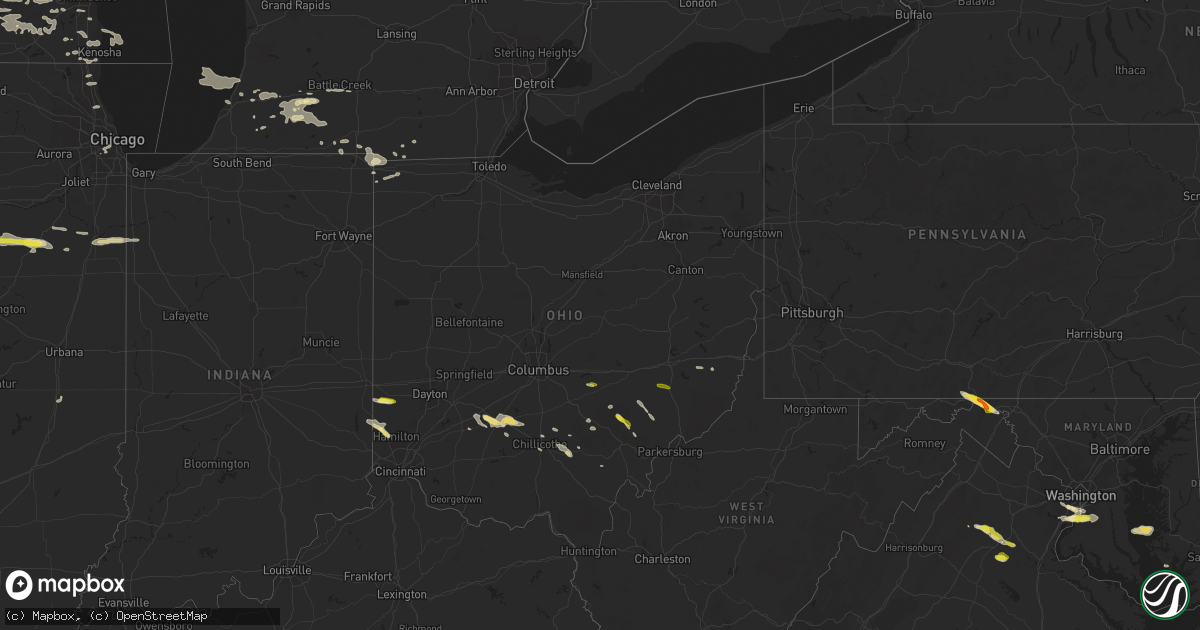
Hail Map in Ohio on May 13, 2018
Get this storm
May 13 map
$229
one time, instant access
Download today. No call, no setup
Keep the $229
Bought the map and want the full workflow? Apply the entire $229 to a subscription within 7 days. None of it is wasted.
Every map, not just this one
This buys you this map. Subscription and you get every map we run, in the markets you choose from a few cities to whole states to nationwide. Plus real-time alerts the moment a storm fires.
Contact data
Name, contact info, occupancy, even credit band for addresses in the footprint. You go from where it hit to who to call.
Become the source they trust
Unlimited branding weather history reports on demand. You already have the documented answer ready for the property owner, and you are the one who showed up with it.
Property data and RoofTrace estimates
Pull up any address you have got, its value and the exact code rules for that jurisdiction, straight from One Click Code. Then RoofTrace estimates the squares, pitch, and roof value, priced the way you price.
Storm reports in Ohio
Ohio
| Date | Description |
|---|---|
| 05/13/20186:24 PM CDT | One small tree down at clemens road and white road. Time estimated from radar. |
| 05/13/20186:03 PM CDT | Trees down |
| 05/13/20185:56 PM CDT | One tree down on blosser road. Time estimated from radar. |
| 05/13/20185:55 PM CDT | Hail of varying sizes... Including some large quarter-size stones. |
| 05/13/20185:25 PM CDT | Trees down |
| 05/13/20184:28 PM CDT | Mostly nickels... But some larger ones closer to quarters |
| 05/13/201812:36 PM CDT | A local report indicates 1.00 inch wind near 2 E RATCLIFFBURG |
| 05/13/20185:37 AM CDT | At 1037 PM EDT, a severe thunderstorm was located near Glouster, moving southeast at 30 mph. HAZARD...60 mph wind gusts and quarter size hail. SOURCE...Radar indicated. IMPACT...Hail damage to vehicles is expected. Expect wind damage to roofs, siding, and trees. Locations impacted include... Glouster, Chesterhill, Corning, Jacksonville, Trimble, Amesville and Burr Oak State Park. |
| 05/13/20185:33 AM CDT | At 1032 PM EDT, a severe thunderstorm was located 9 miles west of Mcarthur, moving southeast at 25 mph. HAZARD...60 mph wind gusts and quarter size hail. SOURCE...Radar indicated. IMPACT...Hail damage to vehicles is expected. Expect wind damage to roofs, siding, and trees. Locations impacted include... Wellston, Mcarthur, Hamden, Byer and Allensville. |
| 05/13/20184:54 AM CDT | At 954 PM EDT, a severe thunderstorm was located over Eaton, moving east at 25 mph. HAZARD...60 mph wind gusts and quarter size hail. SOURCE...Radar indicated. IMPACT...Minor hail damage to vehicles is possible. Expect wind damage to trees and power lines. Locations impacted include... Middletown, Trotwood, Miamisburg, Franklin, Eaton, Moraine, Carlisle, Camden, West Alexandria, Gratis, Germantown, New Lebanon, Farmersville, West Elkton, Poast Town Heights, Wheatville, Muttonville and Lake Lakengren. |
| 05/13/20184:33 AM CDT | At 932 PM EDT, a severe thunderstorm was located over Washington Court House, moving southeast at 25 mph. HAZARD...60 mph wind gusts and quarter size hail. SOURCE...Radar indicated. IMPACT...Minor hail damage to vehicles is possible. Expect wind damage to trees and power lines. Locations impacted include... Washington Court House, Sabina, Williamsport, Bloomingburg, New Holland, Staunton, Good Hope, Frankfort, Clarksburg, Milledgeville, Octa, Austin, Jasper Mills, State Route 207 at US Route 22, Interstate 71 at US Route 35, Plano and Rock Mills.This includes I-71 in Ohio between mile markers 63 and 68. |
| 05/13/20184:28 AM CDT | At 928 PM EDT, a severe thunderstorm was located near New Vienna, moving east at 25 mph. HAZARD...60 mph wind gusts and penny size hail. SOURCE...Radar indicated. IMPACT...Expect damage to trees and power lines. Locations impacted include... Greenfield, Sabina, Leesburg, Staunton, Good Hope, Highland, Lees Creek, Reesville, East Monroe, Rock Mills and New Martinsburg. |
| 05/13/20184:03 AM CDT | At 902 PM EDT, a severe thunderstorm was located over Athens, moving east at 40 mph. HAZARD...60 mph wind gusts and quarter size hail. SOURCE...Radar indicated. IMPACT...Hail damage to vehicles is expected. Expect wind damage to roofs, siding, and trees. Locations impacted include... Athens, Coolville, Stroud Run State Park and The Plains. |
| 05/13/20183:04 AM CDT | At 804 AM EDT, severe thunderstorms were located along a line extending from near Ellwood City to near Ohioville, moving east at 55 mph. HAZARD...Wind gusts to 60 mph. SOURCE...Radar. IMPACT...Expect damage to trees and power lines, resulting in some power outages. Locations impacted include... Pittsburgh... Penn Hills... Ross Township... McCandless Township... Monroeville... Cranberry... Butler... Franklin Park... Aliquippa... Beaver Falls... Monaca... Shaler Township...This includes the following highways... Pennsylvania Turnpike between mile markers 10 and 58. Interstate 79 in Pennsylvania between mile markers 39 and 71. Parkway North between mile markers 6 and 13. |
| 05/13/20182:59 AM CDT | At 759 PM EDT, a severe thunderstorm was located over Shadyside, or near Moundsville, moving east at 40 mph. HAZARD...Wind gusts to 60 mph. SOURCE...Radar. IMPACT...Expect damage to trees and power lines, resulting in some power outages. Locations impacted include... Moundsville... Bellaire... Waynesburg... Shadyside... McMechen... Glen Dale... Benwood... Rogersville... West Finley... Nineveh... Grove Oak... Glendale... |
| 05/13/20182:41 AM CDT | At 740 PM EDT, a severe thunderstorm was located 7 miles south of Williamsport, moving east at 30 mph. HAZARD...Ping pong ball size hail and 60 mph wind gusts. SOURCE...Radar indicated. IMPACT...People and animals outdoors will be injured. Expect hail damage to roofs, siding, windows, and vehicles. Expect wind damage to trees and power lines. Locations impacted include... Chillicothe, Kingston, Williamsport, North Folk Village, Frankfort, Londonderry, Laurelville, Clarksburg, Adelphi, Andersonville, Mooresville, Austin, Whisler, Pickaway County Airport and Hallsville. |
| 05/13/20182:22 AM CDT | At 722 PM EDT, a severe thunderstorm was located over Barnesville, moving east at 30 mph. HAZARD...Wind gusts to 60 mph and quarter-size hail. SOURCE...Radar. IMPACT...Minor hail damage to vehicles is possible. Expect wind damage to trees and power lines, resulting in some power outages. Locations impacted include... St. Clairsville... Barnesville... Bethesda... Belmont... Morristown... Neffs... Barkcamp State Park... This includes Interstate 70 in Ohio between mile markers 202 and221. |
| 05/13/20182:21 AM CDT | At 720 PM EDT, a severe thunderstorm was located near New Holland, moving east at 30 mph. HAZARD...60 mph wind gusts and quarter size hail. SOURCE...Radar indicated. IMPACT...Minor hail damage to vehicles is possible. Expect wind damage to trees and power lines. Locations impacted include... Washington Court House, Williamsport, New Holland, Staunton, Good Hope, Frankfort, Clarksburg, Lattaville, Austin, Jasper Mills, State Route 207 at US Route 22, Rock Mills, Plano and Andersonville. |
| 05/13/20181:54 AM CDT | At 654 PM EDT, a severe thunderstorm was located near Byesville, or near Cambridge, moving east at 15 mph. HAZARD...Wind gusts to 60 mph and quarter-size hail. SOURCE...Radar. IMPACT...Minor hail damage to vehicles is possible. Expect wind damage to trees and power lines, resulting in some power outages. Locations impacted include... Quaker City... Senecaville... Lore City... Old Washington... Salesville... Fairview...This includes Interstate 70 in Ohio between mile markers 182 and200. |
| 05/13/20181:17 AM CDT | At 617 PM EDT, a severe thunderstorm was located 7 miles northwest of Caldwell, moving east-southeast at 40 mph. HAZARD...Wind gusts to 60 mph and quarter-size hail. SOURCE...Radar. IMPACT...Minor hail damage to vehicles is possible. Expect wind damage to trees and power lines, resulting in some power outages. Locations impacted include... Woodsfield... Caldwell... Dudley... Cumberland... Summerfield... Belle Valley... Lewisville... Sarahsville... Dexter City... Antioch... Stafford... Graysville...This includes Interstate 77 in Ohio between mile markers 18 and 34. |
| 05/13/201812:13 AM CDT | At 513 PM EDT, a severe thunderstorm was located near Thornport, or 7 miles west of Somerset, moving east at 30 mph. HAZARD...60 mph wind gusts and quarter size hail. SOURCE...Radar indicated. IMPACT...Hail damage to vehicles is expected. Expect wind damage to roofs, siding, and trees. Locations impacted include... Somerset, Perry State Forest, Crooksville and Glenford. |
| 05/12/20189:46 PM CDT | Called state park. Started small then became quarter sized hail. |
| 05/12/20189:36 PM CDT | A local report indicates 1.00 inch wind near 2 E RATCLIFFBURG |
| 05/12/20188:15 PM CDT | Tree down blocking right hand lane on us 22 and stone road. Time estimated from radar. |
| 05/12/20187:40 PM CDT | Trees down |
| 05/12/20187:36 PM CDT | One small tree down on nichols road and us 27 |
All States Impacted by Hail Map on May 13, 2018
Cities Impacted by Hail Map on May 13, 2018
- Dodgeville, WI
- Spring Green, WI
- Schoenchen, KS
- Hays, KS
- La Crosse, KS
- McCracken, KS
- Gate, OK
- Meade, KS
- Englewood, KS
- Booker, TX
- Perryton, TX
- Balko, OK
- Haviland, KS
- Coloma, MI
- Watervliet, MI
- Covert, MI
- Hartford, MI
- Lawrence, MI
- Macksburg, IA
- Orient, IA
- Creston, IA
- Lorimor, IA
- Greenfield, IA
- Miami, TX
- Beaver, OK
- Spearman, TX
- Ely, IA
- Cedar Rapids, IA
- Mount Vernon, IA
- Keota, IA
- Ollie, IA
- Sigourney, IA
- Richland, IA
- Eaton, OH
- Quanah, TX
- Eldorado, OK
- Greenleaf, KS
- West Branch, IA
- Granger, IA
- Grimes, IA
- Kearney, NE
- Riverdale, NE
- Fowler, KS
- Memphis, TX
- Wellington, TX
- Hedley, TX
- Center Junction, IA
- Anamosa, IA
- Cambridge, MD
- Culpeper, VA
- Rhoadesville, VA
- Burr Hill, VA
- Locust Grove, VA
- Wyoming, IA
- Shenandoah, IA
- Coin, IA
- Clarinda, IA
- Minneapolis, KS
- Washington Court House, OH
- Shannon, IL
- Pearl City, IL
- Mount Carroll, IL
- Lanark, IL
- Childress, TX
- Shamrock, TX
- Wisner, NE
- Masonville, IA
- Ryan, IA
- Manchester, IA
- Bartley, NE
- Cambridge, NE
- Odell, IL
- Dwight, IL
- Mobeetie, TX
- Lincoln, KS
- Fairfax, IA
- Norway, IA
- Atkins, IA
- Palo, IA
- Newhall, IA
- Cabery, IL
- Indianola, IA
- New Virginia, IA
- Sidney, IA
- Chadwick, IL
- Morrison, IL
- Table Rock, NE
- Steinauer, NE
- Pawnee City, NE
- Elizabeth, CO
- Tell, TX
- Matador, TX
- Berkeley Springs, WV
- Hedgesville, WV
- Big Pool, MD
- Hancock, MD
- Hollandale, WI
- Wingate, MD
- Toddville, MD
- Turon, KS
- Alexandria, VA
- Accokeek, MD
- Clinton, MD
- Fort Washington, MD
- Logan, IA
- Briscoe, TX
- Wheeler, TX
- Canadian, TX
- Reydon, OK
- Lakeview, TX
- Turkey, TX
- Hamilton, IN
- Edon, OH
- Daphne, AL
- Ridott, IL
- Baileyville, IL
- German Valley, IL
- Leaf River, IL
- Freeport, IL
- Forreston, IL
- Pecatonica, IL
- Thomson, IL
- Offerle, KS
- Sparland, IL
- Speer, IL
- Bradford, IL
- Wyoming, IL
- Johnson, NE
- Elk Creek, NE
- Humboldt, NE
- Auburn, NE
- Arion, IA
- Dow City, IA
- Denison, IA
- Bussey, IA
- Columbia, IA
- Hamilton, IA
- Knoxville, IA
- Durango, IA
- Sherrill, IA
- Rowley, IA
- Walker, IA
- Brandon, IA
- Burr Oak, MI
- Sturgis, MI
- Grand Mound, IA
- Calamus, IA
- De Witt, IA
- Hoisington, KS
- Otis, KS
- Albert, KS
- Olmitz, KS
- Byron, IL
- Chebanse, IL
- Saint Anne, IL
- Pembroke Township, IL
- Morocco, IN
- Kankakee, IL
- Sawyer, KS
- Larned, KS
- Bronson, MI
- Orland, IN
- Burchard, NE
- Liberty, NE
- Brownville, NE
- Nemaha, NE
- Elizabeth, IL
- Stockton, IL
- Savanna, IL
- Kent, IL
- Arnett, OK
- Mineral Point, WI
- Rewey, WI
- Ellsworth, KS
- West Point, NE
- Bethesda, OH
- Mountain Park, OK
- Blair, OK
- Woodbine, IA
- Ainsworth, IA
- Red Oak, IA
- Defiance, IA
- Altus, OK
- Fairhope, AL
- Foley, AL
- Bazine, KS
- Laverne, OK
- Holbrook, NE
- Arapahoe, NE
- Wheatland, IA
- Deer Trail, CO
- Baldwin, IA
- Maquoketa, IA
- Fremont, NE
- Tescott, KS
- Beverly, KS
- Walnut, IL
- Polo, IL
- Barnard, KS
- Thornville, OH
- Rushville, OH
- Pleasantville, OH
- Stockport, OH
- Waterford, OH
- Vail, IA
- Percival, IA
- Nebraska City, NE
- Syracuse, NE
- Hamburg, IA
- Dunbar, NE
- Thurman, IA
- Talmage, NE
- Lorton, NE
- Palmer, KS
- Linn, KS
- Washington, NE
- Waterloo, NE
- Missouri Valley, IA
- Kennard, NE
- Fort Calhoun, NE
- Blair, NE
- Elkhorn, NE
- Bennington, NE
- Omaha, NE
- Valley, NE
- Yutan, NE
- Kiowa, CO
- Calhan, CO
- Agate, CO
- Elbert, CO
- Ramah, CO
- Pampa, TX
- Fontanelle, IA
- Bridgewater, IA
- Monticello, IA
- Dallas Center, IA
- Springfield, VA
- Oregon, WI
- Madison, WI
- Mcfarland, WI
- Defuniak Springs, FL
- Hosford, FL
- Bristol, FL
- Mangum, OK
- Quitaque, TX
- Paducah, TX
- Gould, OK
- Cee Vee, TX
- Letts, IA
- Duke, OK
- Higgins, TX
- Hartwick, IA
- Chelsea, IA
- Brooklyn, IA
- McCook, NE
- Indianola, NE
- Barnes, KS
- Kinsley, KS
- Lost Nation, IA
- Wenona, IL
- Miles, IA
- Bryant, IA
- Preston, IA
- Mahaska, KS
- Jamestown, OH
- Sabina, OH
- Schoolcraft, MI
- Delmar, IA
- Charlotte, IA
- Crawfordsville, IA
- Oxford, IA
- Middle Amana, IA
- Marengo, IA
- Swisher, IA
- South Amana, IA
- Homestead, IA
- Amana, IA
- Dixon, IL
- Hebron, NE
- Rozel, KS
- Milledgeville, IL
- Hopkinton, IA
- Rock Port, MO
- Fort Belvoir, VA
- Bryans Road, MD
- Brandywine, MD
- Alva, OK
- Oxford, OH
- Hamilton, OH
- Monmouth, IA
- Cook, NE
- Brock, NE
- Tecumseh, NE
- Elm Creek, NE
- Overton, NE
- Loomis, NE
- Bertrand, NE
- Adams, NE
- Cortland, NE
- Pickrell, NE
- Clay Center, KS
- Verona, WI
- Cross Plains, WI
- Curtis, NE
- Maywood, NE
- Danbury, NE
- Westville, FL
- Zwingle, IA
- Bellevue, IA
- Spragueville, IA
- La Motte, IA
- Hanover, IL
- Bernard, IA
- Barneveld, WI
- Franksville, WI
- Union Grove, WI
- Sturtevant, WI
- Salem, NE
- Winterset, IA
- Clarendon, TX
- Wymore, NE
- Oketo, KS
- Barneston, NE
- Marysville, KS
- Snyder, OK
- Mclean, TX
- Oneida, IL
- Aledo, IL
- Rio, IL
- North Henderson, IL
- Alexis, IL
- Franktown, CO
- Wilson, KS
- Dorrance, KS
- Shelbyville, IN
- Arlington, IN
- Morristown, IN
- Gwynneville, IN
- Ladora, IA
- Sylvan Grove, KS
- Mineral Wells, WV
- Bennington, KS
- Alexander, KS
- Stoughton, WI
- Edgerton, WI
- Clear Spring, MD
- Falling Waters, WV
- Needmore, PA
- Warfordsburg, PA
- Shorterville, AL
- Leonidas, MI
- Mendon, MI
- Colon, MI
- Jansen, NE
- Diller, NE
- Beatrice, NE
- Sterling, IL
- Woosung, IL
- Mount Morris, IL
- Oregon, IL
- Toulon, IL
- La Fayette, IL
- South Bloomingville, OH
- Vicksburg, MI
- Kalamazoo, MI
- Portage, MI
- Scotts, MI
- Wellsburg, IA
- Stockton, IA
- Alburnett, IA
- Marion, IA
- Central City, IA
- Fremont, IA
- New Sharon, IA
- Oskaloosa, IA
- Beacon, IA
- University Park, IA
- Chariton, IA
- Cedar, IA
- Eddyville, IA
- Lovilia, IA
- Rose Hill, IA
- Tracy, IA
- Lacona, IA
- West Chester, IA
- Washington, IA
- Walford, IA
- Williamsburg, IA
- Tiffin, IA
- Vinton, IA
- Mount Auburn, IA
- Columbus Junction, IA
- Miltonvale, KS
- Clinton, IA
- Sabula, IA
- Sterling, NE
- Burr, NE
- Harper, IA
- South English, IA
- Brighton, IA
- Webster, IA
- Hedrick, IA
- Eustis, NE
- Moorefield, NE
- Kansasville, WI
- Burlington, WI
- Lorton, VA
- Waldorf, MD
- Ridgeway, WI
- Paw Paw, MI
- Center Point, IA
- South Haven, MI
- Morrowville, KS
- Bunker Hill, KS
- Greensburg, KS
- Ackley, IA
- Aplington, IA
- Holland, IA
- Parkersburg, IA
- Osseo, MI
- Camden, MI
- Hillsdale, MI
- Galva, IL
- Wataga, IL
- Victoria, IL
- Henderson, IL
- Monmouth, IL
- Little York, IL
- Galesburg, IL
- Altona, IL
- Gerlaw, IL
- Dawson, NE
- Winnebago, IL
- Hollenberg, KS
- Loxley, AL
- Fairbury, NE
- Plymouth, NE
- Steele City, NE
- Endicott, NE
- De Witt, NE
- Lipscomb, TX
- Follett, TX
- Sperryville, VA
- Durant, IA
- Walcott, IA
- New Liberty, IA
- Auburn, IA
- McCausland, IA
- Camanche, IA
- Manilla, IA
- Irwin, IA
- Delphos, KS
- Long Grove, IA
- Eldridge, IA
- Elkhorn, WI
- Fort Atkinson, WI
- Delavan, WI
- Milton, WI
- East Troy, WI
- Whitewater, WI
- Leighton, IA
- What Cheer, IA
- Melcher Dallas, IA
- Hayesville, IA
- Russell, IA
- Harvey, IA
- Delta, IA
- West College Corner, IN
- Bath, IN
- Liberty, IN
- Cascade, IA
- Lowden, IA
- Clarence, IA
- Oakland, NE
- Springville, IA
- Martelle, IA
- Dowagiac, MI
- Cassopolis, MI
- Mechanicsville, IA
- Lisbon, IA
- Stanwood, IA
- Tipton, IA
- Protection, KS
- Ashland, KS
- Pittsford, MI
- New Holland, OH
- Clarksburg, OH
- Belle Plaine, IA
- Le Claire, IA
- Farley, IA
- Epworth, IA
- Onslow, IA
- Peosta, IA
- North Liberty, IA
- Galena, IL
- Solon, IA
- Morley, IA
- Olin, IA
- Victor, IA
- Andrew, IA
- Oxford Junction, IA
- Conroy, IA
- Dubuque, IA
- Guernsey, IA
- Worthington, IA
- Libertyville, IL
- Waukegan, IL
- North Chicago, IL
- Decatur, NE
- Tekamah, NE
- Brownell, KS
- Catharine, KS
- Plainville, KS
- Ellis, KS
- Florala, AL
- Claflin, KS
- Alton, KS
- Massena, IA
- Anita, IA
- Georgetown, DE
- Seaford, DE
- Laurel, DE
- Ancona, IL
- Streator, IL
- Cornell, IL
- Blackstone, IL
- Emington, IL
- Toddville, IA
- Londonderry, OH
- Ray, OH
- Bison, KS
- Coggon, IA
- Clearville, PA
- Artemas, PA
- Roosevelt, OK
- Olustee, OK
- Headrick, OK
- Modale, IA
- Climax, MI
- Battle Creek, MI
- Angola, IN
- Montpelier, OH
- Fremont, IN
- Pioneer, OH
- Montgomery, MI
- Gill, CO
- Kersey, CO
- Greeley, CO
- La Salle, CO
- Evans, CO
- Briggsdale, CO
- Rush Center, KS
- Deerfield, WI
- Cambridge, WI
- Pilger, NE
- Bristol, WI
- Steamboat Rock, IA
- Saint Charles, IA
- Rixeyville, VA
- Castleton, VA
- Three Rivers, MI
- Marcellus, MI
- Albany, OH
- Woodville, VA
- Traer, IA
- Independence, IA
- Fulton, IL
- Cassville, WI
- Potosi, WI
- Holy Cross, IA
- Iowa City, IA
- Coralville, IA
- Bedford, PA
- Daleville, AL
- Keystone, IA
- Elberon, IA
- Russell, KS
- Long Point, IL
- Dana, IL
- Villisca, IA
- Teeds Grove, IA
- Cottage Grove, WI
- Gurnee, IL
- Dixon, IA
- Goose Lake, IA
- Wilton, IA
- Donahue, IA
- Bennett, IA
- Guttenberg, IA
- Colesburg, IA
- Rochester, IN
- Menlo, IA
- Greenfield, OH
- Belleville, KS
- Chester, NE
- Scandia, KS
- Republic, KS
- Reddick, IL
- Gardner, IL
- Wilmington, OH
- Yorktown, IA
- Hanover, KS
- Bremen, KS
- Minneola, KS
- Freedom, OK
- Honey Creek, IA
- Dyersville, IA
- Fairfax, MO
- Hudson, CO
- Keenesburg, CO
- Bennett, CO
- Westside, IA
- Arcadia, IA
- Dunlap, IA
- Breda, IA
- Mount Horeb, WI
- Wapello, IA
- Conesville, IA
- Waukee, IA
- Chicago, IL
- Craig, NE
- Arlington, NE
- Randolph, IA
- Axtell, KS
- Tabor, IA
- Peru, NE
- Baileyville, KS
- Farragut, IA
- Imogene, IA
- Helenville, WI
- Jefferson, WI
- Lucas, IA
- Coden, AL
- Theodore, AL
- Irvington, AL
- Watkins, IA
- Blairstown, IA
- Sullivan, WI
- Rushville, IN
- Fountaintown, IN
- Searsboro, IA
- Lynnville, IA
- Luray, KS
- Lucas, KS
- Chillicothe, OH
- Alexandria, NE
- Edgewood, IA
- Winamac, IN
- Kewanna, IN
- Filley, NE
- Crab Orchard, NE
- Odell, NE
- Douglas, NE
- Hudson, MI
- Amesville, OH
- Boulder, CO
- Silver Lake, WI
- Salem, WI
- Princess Anne, MD
- Eden, MD
- Firth, NE
- Green, KS
- Platteville, WI
- Glouster, OH
- Dysart, IA
- Decatur, MI
- Franklin, WI
- Greendale, WI
- Ness City, KS
- Courtland, KS
- Elkwood, VA
- Sumerduck, VA
- Remington, VA
- Brandy Station, VA
- Amissville, VA
- Lyons, NE
- Cordova, IL
- Princeton, IA
- Oconomowoc, WI
- Delafield, WI
- Wales, WI
- Dousman, WI
- Waukesha, WI
- Shattuck, OK
- West Unity, OH
- Earlville, IA
- Delhi, IA
- Beemer, NE
- Snow Hill, MD
- Coldwater, MI
- Reading, MI
- Prole, IA
- Norwalk, IA
- Cuba City, WI
- Concordia, KS
- Northbrook, IL
- Waldron, MI
- Buffalo, OK
- Corning, IA
- Carbon, IA
- Lacon, IL
- Varna, IL
- Henry, IL
- Chillicothe, IL
- Quaker City, OH
- Barnesville, OH
- Everett, PA
- Salisbury, MD
- Parsonsburg, MD
- Clatonia, NE
- Milo, IA
- Belmont, WI
- Bangor, MI
- Waterloo, WI
- Mcconnelsville, OH
- Malta, OH
- Panama, IA
- Van Horne, IA
- Kenosha, WI
- Racine, WI
- Flomot, TX
- Clive, IA
- Johnston, IA
- Urbandale, IA
- Muscatine, IA
- Grandview, IA
- Stockville, NE
- Cumming, IA
- West Des Moines, IA
- Reynolds, IL
- Viola, IL
- Alpha, IL
- Woodhull, IL
- New Windsor, IL
- Elwood, NE
- Smithfield, NE
- Verdon, NE
- Clifton, KS
- Osceola, IA
- Elmwood, NE
- Murdock, NE
- Millersburg, IN
- Buffalo Mills, PA
- Prairieburg, IA
- Rutland, IL
- Gilead, NE
- Winthrop, IA
- Logan, OH
- Benton Harbor, MI
- Indianapolis, IN
- Fairland, IN
- McArthur, OH
- Forgan, OK
- Plains, KS
- Bethel, DE
- Camden, OH
- West Alexandria, OH
- Stillman Valley, IL
- Magnolia, IL
- Tuscola, IL
- Arcola, IL
- Adel, IA
- De Soto, IA
- Van Meter, IA
- Eglin Afb, FL
- Ceresco, MI
- Pella, IA
- Bonfield, IL
- Morganville, KS
- Aurora, KS
- Natoma, KS
- Manns Choice, PA
- Schellsburg, PA
- Pleasant Prairie, WI
- Zion, IL
- Lake Mills, WI
- Grinnell, IA
- Kingston, OH
- Laurelville, OH
- Janesville, IA
- Muskego, WI
- Big Bend, WI
- Malcom, IA
- Prescott, IA
- Truro, IA
- Peru, IA
- Murray, IA
- Crescent, IA
- Mondamin, IA
- Magnolia, IA
- Neola, IA
- Griswold, IA
- Glen Haven, WI
- Lawton, MI
- Mattawan, MI
- Beloit, KS
- Blue Mounds, WI
- Ponce De Leon, FL
- Waterford, WI
- Eagle, WI
- Mukwonago, WI
- Annandale, VA
- Fairfax, VA
- Oxon Hill, MD
- Coldwater, KS
- Oak Creek, WI
- New Lexington, OH
- Shawnee, OH
- Stuart, IA
- Union, NE
- Central City, PA
- Stoystown, PA
- La Porte City, IA
- Gorham, KS
- Lewis, KS
- Liebenthal, KS
- Garfield, KS
- Woodrow, CO
- Colorado Springs, CO
- Somerset, OH
- Caldwell, OH
- Cumberland, OH
- Lignum, VA
- Toluca, IL


