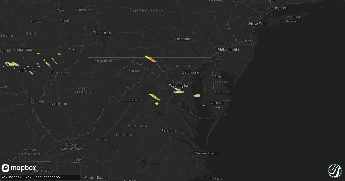
Hail Map in Maryland on May 13, 2018
Get this storm
May 13 map
$229
one time, instant access
Download today. No call, no setup
Keep the $229
Bought the map and want the full workflow? Apply the entire $229 to a subscription within 7 days. None of it is wasted.
Every map, not just this one
This buys you this map. Subscription and you get every map we run, in the markets you choose from a few cities to whole states to nationwide. Plus real-time alerts the moment a storm fires.
Contact data
Name, contact info, occupancy, even credit band for addresses in the footprint. You go from where it hit to who to call.
Become the source they trust
Unlimited branding weather history reports on demand. You already have the documented answer ready for the property owner, and you are the one who showed up with it.
Property data and RoofTrace estimates
Pull up any address you have got, its value and the exact code rules for that jurisdiction, straight from One Click Code. Then RoofTrace estimates the squares, pitch, and roof value, priced the way you price.
Storm reports in Maryland
Maryland
| Date | Description |
|---|---|
| 05/13/20186:15 PM CDT | A local report indicates 1.75 inch wind near 3 E HANCOCK |
| 05/13/20186:19 AM CDT | At 1119 PM EDT, a severe thunderstorm was located near University Of Maryland Center For Environmental Studies, or 7 miles west of Cambridge, moving east at 25 mph. HAZARD...Half dollar size hail. SOURCE...Radar indicated. IMPACT...Minor damage to vehicles is possible. This severe thunderstorm will be near, University Of Maryland Center For Environmental Studies around 1135 PM EDT. Cambridge around 1140 PM EDT. Other locations impacted by this severe thunderstorm include Madison,Church Creek, Bucktown, Woolford, Hudson and Lloyds. |
| 05/13/20185:12 AM CDT | At 1012 PM EDT, a severe thunderstorm was located over Fort Belvoir, moving east at 15 mph. HAZARD...Quarter size hail. SOURCE...Radar indicated. IMPACT...Some hail damage to agriculture is expected. Locations impacted include... Waldorf, Clinton, Springfield, Fort Washington, Fort Hunt, Groveton, Forestville, Fort Belvoir, National Harbor, Andrews Air Force Base, Camp Springs, Lorton, Franconia, Oxon Hill, Hybla Valley, Newington, Rosaryville, Friendly, Marlton and Temple Hills. |
| 05/13/20181:50 AM CDT | At 650 PM EDT, severe thunderstorms were located along a line extending from near Barnes Gap to near Inglesmith, moving southeast at 30 mph. HAZARD...60 mph wind gusts and quarter size hail. SOURCE...Radar indicated. IMPACT...Damaging winds will cause some trees and large branches to fall. This could injure those outdoors, as well as damage homes and vehicles. Roadways may become blocked by downed trees. Localized power outages are possible. Unsecured light objects may become projectiles. Locations impacted include... Martinsburg, Hancock, Greenwood, Inwood, Williamsport, Berkeley Springs, Saint James, Berkeley, Falling Waters, Fairplay, Great Cacapon, Clear Spring, Hedgesville, Pecktonville, Big Spring, Big Pool, Little Orleans, Johnsons Mill, Tomahawk and Johnsontown. |
| 05/13/20181:00 AM CDT | At 600 PM EDT, severe thunderstorms were located along a line extending from Ogletown to 6 miles southwest of Central City to near New Centerville, moving southeast at 30 mph. HAZARD...60 mph wind gusts and quarter size hail. SOURCE...Radar indicated. IMPACT...Hail damage to vehicles is possible. Expect wind damage to trees and power lines. Locations impacted include... Breezewood, Bedford, Lake Gordon, Clearville, Everett, Buffalo Mills, Cessna, Inglesmith, Rainsburg and Hyndman.This includes the following Interstates... Interstate 70 from mile markers 147 to 150. The Pennsylvania Turnpike from mile markers 130 to 163. Interstate 99 from mile markers 0 to 6. |
All States Impacted by Hail Map on May 13, 2018
Cities Impacted by Hail Map on May 13, 2018
- Dodgeville, WI
- Spring Green, WI
- Schoenchen, KS
- Hays, KS
- La Crosse, KS
- McCracken, KS
- Gate, OK
- Meade, KS
- Englewood, KS
- Booker, TX
- Perryton, TX
- Balko, OK
- Haviland, KS
- Coloma, MI
- Watervliet, MI
- Covert, MI
- Hartford, MI
- Lawrence, MI
- Macksburg, IA
- Orient, IA
- Creston, IA
- Lorimor, IA
- Greenfield, IA
- Miami, TX
- Beaver, OK
- Spearman, TX
- Ely, IA
- Cedar Rapids, IA
- Mount Vernon, IA
- Keota, IA
- Ollie, IA
- Sigourney, IA
- Richland, IA
- Eaton, OH
- Quanah, TX
- Eldorado, OK
- Greenleaf, KS
- West Branch, IA
- Granger, IA
- Grimes, IA
- Kearney, NE
- Riverdale, NE
- Fowler, KS
- Memphis, TX
- Wellington, TX
- Hedley, TX
- Center Junction, IA
- Anamosa, IA
- Cambridge, MD
- Culpeper, VA
- Rhoadesville, VA
- Burr Hill, VA
- Locust Grove, VA
- Wyoming, IA
- Shenandoah, IA
- Coin, IA
- Clarinda, IA
- Minneapolis, KS
- Washington Court House, OH
- Shannon, IL
- Pearl City, IL
- Mount Carroll, IL
- Lanark, IL
- Childress, TX
- Shamrock, TX
- Wisner, NE
- Masonville, IA
- Ryan, IA
- Manchester, IA
- Bartley, NE
- Cambridge, NE
- Odell, IL
- Dwight, IL
- Mobeetie, TX
- Lincoln, KS
- Fairfax, IA
- Norway, IA
- Atkins, IA
- Palo, IA
- Newhall, IA
- Cabery, IL
- Indianola, IA
- New Virginia, IA
- Sidney, IA
- Chadwick, IL
- Morrison, IL
- Table Rock, NE
- Steinauer, NE
- Pawnee City, NE
- Elizabeth, CO
- Tell, TX
- Matador, TX
- Berkeley Springs, WV
- Hedgesville, WV
- Big Pool, MD
- Hancock, MD
- Hollandale, WI
- Wingate, MD
- Toddville, MD
- Turon, KS
- Alexandria, VA
- Accokeek, MD
- Clinton, MD
- Fort Washington, MD
- Logan, IA
- Briscoe, TX
- Wheeler, TX
- Canadian, TX
- Reydon, OK
- Lakeview, TX
- Turkey, TX
- Hamilton, IN
- Edon, OH
- Daphne, AL
- Ridott, IL
- Baileyville, IL
- German Valley, IL
- Leaf River, IL
- Freeport, IL
- Forreston, IL
- Pecatonica, IL
- Thomson, IL
- Offerle, KS
- Sparland, IL
- Speer, IL
- Bradford, IL
- Wyoming, IL
- Johnson, NE
- Elk Creek, NE
- Humboldt, NE
- Auburn, NE
- Arion, IA
- Dow City, IA
- Denison, IA
- Bussey, IA
- Columbia, IA
- Hamilton, IA
- Knoxville, IA
- Durango, IA
- Sherrill, IA
- Rowley, IA
- Walker, IA
- Brandon, IA
- Burr Oak, MI
- Sturgis, MI
- Grand Mound, IA
- Calamus, IA
- De Witt, IA
- Hoisington, KS
- Otis, KS
- Albert, KS
- Olmitz, KS
- Byron, IL
- Chebanse, IL
- Saint Anne, IL
- Pembroke Township, IL
- Morocco, IN
- Kankakee, IL
- Sawyer, KS
- Larned, KS
- Bronson, MI
- Orland, IN
- Burchard, NE
- Liberty, NE
- Brownville, NE
- Nemaha, NE
- Elizabeth, IL
- Stockton, IL
- Savanna, IL
- Kent, IL
- Arnett, OK
- Mineral Point, WI
- Rewey, WI
- Ellsworth, KS
- West Point, NE
- Bethesda, OH
- Mountain Park, OK
- Blair, OK
- Woodbine, IA
- Ainsworth, IA
- Red Oak, IA
- Defiance, IA
- Altus, OK
- Fairhope, AL
- Foley, AL
- Bazine, KS
- Laverne, OK
- Holbrook, NE
- Arapahoe, NE
- Wheatland, IA
- Deer Trail, CO
- Baldwin, IA
- Maquoketa, IA
- Fremont, NE
- Tescott, KS
- Beverly, KS
- Walnut, IL
- Polo, IL
- Barnard, KS
- Thornville, OH
- Rushville, OH
- Pleasantville, OH
- Stockport, OH
- Waterford, OH
- Vail, IA
- Percival, IA
- Nebraska City, NE
- Syracuse, NE
- Hamburg, IA
- Dunbar, NE
- Thurman, IA
- Talmage, NE
- Lorton, NE
- Palmer, KS
- Linn, KS
- Washington, NE
- Waterloo, NE
- Missouri Valley, IA
- Kennard, NE
- Fort Calhoun, NE
- Blair, NE
- Elkhorn, NE
- Bennington, NE
- Omaha, NE
- Valley, NE
- Yutan, NE
- Kiowa, CO
- Calhan, CO
- Agate, CO
- Elbert, CO
- Ramah, CO
- Pampa, TX
- Fontanelle, IA
- Bridgewater, IA
- Monticello, IA
- Dallas Center, IA
- Springfield, VA
- Oregon, WI
- Madison, WI
- Mcfarland, WI
- Defuniak Springs, FL
- Hosford, FL
- Bristol, FL
- Mangum, OK
- Quitaque, TX
- Paducah, TX
- Gould, OK
- Cee Vee, TX
- Letts, IA
- Duke, OK
- Higgins, TX
- Hartwick, IA
- Chelsea, IA
- Brooklyn, IA
- McCook, NE
- Indianola, NE
- Barnes, KS
- Kinsley, KS
- Lost Nation, IA
- Wenona, IL
- Miles, IA
- Bryant, IA
- Preston, IA
- Mahaska, KS
- Jamestown, OH
- Sabina, OH
- Schoolcraft, MI
- Delmar, IA
- Charlotte, IA
- Crawfordsville, IA
- Oxford, IA
- Middle Amana, IA
- Marengo, IA
- Swisher, IA
- South Amana, IA
- Homestead, IA
- Amana, IA
- Dixon, IL
- Hebron, NE
- Rozel, KS
- Milledgeville, IL
- Hopkinton, IA
- Rock Port, MO
- Fort Belvoir, VA
- Bryans Road, MD
- Brandywine, MD
- Alva, OK
- Oxford, OH
- Hamilton, OH
- Monmouth, IA
- Cook, NE
- Brock, NE
- Tecumseh, NE
- Elm Creek, NE
- Overton, NE
- Loomis, NE
- Bertrand, NE
- Adams, NE
- Cortland, NE
- Pickrell, NE
- Clay Center, KS
- Verona, WI
- Cross Plains, WI
- Curtis, NE
- Maywood, NE
- Danbury, NE
- Westville, FL
- Zwingle, IA
- Bellevue, IA
- Spragueville, IA
- La Motte, IA
- Hanover, IL
- Bernard, IA
- Barneveld, WI
- Franksville, WI
- Union Grove, WI
- Sturtevant, WI
- Salem, NE
- Winterset, IA
- Clarendon, TX
- Wymore, NE
- Oketo, KS
- Barneston, NE
- Marysville, KS
- Snyder, OK
- Mclean, TX
- Oneida, IL
- Aledo, IL
- Rio, IL
- North Henderson, IL
- Alexis, IL
- Franktown, CO
- Wilson, KS
- Dorrance, KS
- Shelbyville, IN
- Arlington, IN
- Morristown, IN
- Gwynneville, IN
- Ladora, IA
- Sylvan Grove, KS
- Mineral Wells, WV
- Bennington, KS
- Alexander, KS
- Stoughton, WI
- Edgerton, WI
- Clear Spring, MD
- Falling Waters, WV
- Needmore, PA
- Warfordsburg, PA
- Shorterville, AL
- Leonidas, MI
- Mendon, MI
- Colon, MI
- Jansen, NE
- Diller, NE
- Beatrice, NE
- Sterling, IL
- Woosung, IL
- Mount Morris, IL
- Oregon, IL
- Toulon, IL
- La Fayette, IL
- South Bloomingville, OH
- Vicksburg, MI
- Kalamazoo, MI
- Portage, MI
- Scotts, MI
- Wellsburg, IA
- Stockton, IA
- Alburnett, IA
- Marion, IA
- Central City, IA
- Fremont, IA
- New Sharon, IA
- Oskaloosa, IA
- Beacon, IA
- University Park, IA
- Chariton, IA
- Cedar, IA
- Eddyville, IA
- Lovilia, IA
- Rose Hill, IA
- Tracy, IA
- Lacona, IA
- West Chester, IA
- Washington, IA
- Walford, IA
- Williamsburg, IA
- Tiffin, IA
- Vinton, IA
- Mount Auburn, IA
- Columbus Junction, IA
- Miltonvale, KS
- Clinton, IA
- Sabula, IA
- Sterling, NE
- Burr, NE
- Harper, IA
- South English, IA
- Brighton, IA
- Webster, IA
- Hedrick, IA
- Eustis, NE
- Moorefield, NE
- Kansasville, WI
- Burlington, WI
- Lorton, VA
- Waldorf, MD
- Ridgeway, WI
- Paw Paw, MI
- Center Point, IA
- South Haven, MI
- Morrowville, KS
- Bunker Hill, KS
- Greensburg, KS
- Ackley, IA
- Aplington, IA
- Holland, IA
- Parkersburg, IA
- Osseo, MI
- Camden, MI
- Hillsdale, MI
- Galva, IL
- Wataga, IL
- Victoria, IL
- Henderson, IL
- Monmouth, IL
- Little York, IL
- Galesburg, IL
- Altona, IL
- Gerlaw, IL
- Dawson, NE
- Winnebago, IL
- Hollenberg, KS
- Loxley, AL
- Fairbury, NE
- Plymouth, NE
- Steele City, NE
- Endicott, NE
- De Witt, NE
- Lipscomb, TX
- Follett, TX
- Sperryville, VA
- Durant, IA
- Walcott, IA
- New Liberty, IA
- Auburn, IA
- McCausland, IA
- Camanche, IA
- Manilla, IA
- Irwin, IA
- Delphos, KS
- Long Grove, IA
- Eldridge, IA
- Elkhorn, WI
- Fort Atkinson, WI
- Delavan, WI
- Milton, WI
- East Troy, WI
- Whitewater, WI
- Leighton, IA
- What Cheer, IA
- Melcher Dallas, IA
- Hayesville, IA
- Russell, IA
- Harvey, IA
- Delta, IA
- West College Corner, IN
- Bath, IN
- Liberty, IN
- Cascade, IA
- Lowden, IA
- Clarence, IA
- Oakland, NE
- Springville, IA
- Martelle, IA
- Dowagiac, MI
- Cassopolis, MI
- Mechanicsville, IA
- Lisbon, IA
- Stanwood, IA
- Tipton, IA
- Protection, KS
- Ashland, KS
- Pittsford, MI
- New Holland, OH
- Clarksburg, OH
- Belle Plaine, IA
- Le Claire, IA
- Farley, IA
- Epworth, IA
- Onslow, IA
- Peosta, IA
- North Liberty, IA
- Galena, IL
- Solon, IA
- Morley, IA
- Olin, IA
- Victor, IA
- Andrew, IA
- Oxford Junction, IA
- Conroy, IA
- Dubuque, IA
- Guernsey, IA
- Worthington, IA
- Libertyville, IL
- Waukegan, IL
- North Chicago, IL
- Decatur, NE
- Tekamah, NE
- Brownell, KS
- Catharine, KS
- Plainville, KS
- Ellis, KS
- Florala, AL
- Claflin, KS
- Alton, KS
- Massena, IA
- Anita, IA
- Georgetown, DE
- Seaford, DE
- Laurel, DE
- Ancona, IL
- Streator, IL
- Cornell, IL
- Blackstone, IL
- Emington, IL
- Toddville, IA
- Londonderry, OH
- Ray, OH
- Bison, KS
- Coggon, IA
- Clearville, PA
- Artemas, PA
- Roosevelt, OK
- Olustee, OK
- Headrick, OK
- Modale, IA
- Climax, MI
- Battle Creek, MI
- Angola, IN
- Montpelier, OH
- Fremont, IN
- Pioneer, OH
- Montgomery, MI
- Gill, CO
- Kersey, CO
- Greeley, CO
- La Salle, CO
- Evans, CO
- Briggsdale, CO
- Rush Center, KS
- Deerfield, WI
- Cambridge, WI
- Pilger, NE
- Bristol, WI
- Steamboat Rock, IA
- Saint Charles, IA
- Rixeyville, VA
- Castleton, VA
- Three Rivers, MI
- Marcellus, MI
- Albany, OH
- Woodville, VA
- Traer, IA
- Independence, IA
- Fulton, IL
- Cassville, WI
- Potosi, WI
- Holy Cross, IA
- Iowa City, IA
- Coralville, IA
- Bedford, PA
- Daleville, AL
- Keystone, IA
- Elberon, IA
- Russell, KS
- Long Point, IL
- Dana, IL
- Villisca, IA
- Teeds Grove, IA
- Cottage Grove, WI
- Gurnee, IL
- Dixon, IA
- Goose Lake, IA
- Wilton, IA
- Donahue, IA
- Bennett, IA
- Guttenberg, IA
- Colesburg, IA
- Rochester, IN
- Menlo, IA
- Greenfield, OH
- Belleville, KS
- Chester, NE
- Scandia, KS
- Republic, KS
- Reddick, IL
- Gardner, IL
- Wilmington, OH
- Yorktown, IA
- Hanover, KS
- Bremen, KS
- Minneola, KS
- Freedom, OK
- Honey Creek, IA
- Dyersville, IA
- Fairfax, MO
- Hudson, CO
- Keenesburg, CO
- Bennett, CO
- Westside, IA
- Arcadia, IA
- Dunlap, IA
- Breda, IA
- Mount Horeb, WI
- Wapello, IA
- Conesville, IA
- Waukee, IA
- Chicago, IL
- Craig, NE
- Arlington, NE
- Randolph, IA
- Axtell, KS
- Tabor, IA
- Peru, NE
- Baileyville, KS
- Farragut, IA
- Imogene, IA
- Helenville, WI
- Jefferson, WI
- Lucas, IA
- Coden, AL
- Theodore, AL
- Irvington, AL
- Watkins, IA
- Blairstown, IA
- Sullivan, WI
- Rushville, IN
- Fountaintown, IN
- Searsboro, IA
- Lynnville, IA
- Luray, KS
- Lucas, KS
- Chillicothe, OH
- Alexandria, NE
- Edgewood, IA
- Winamac, IN
- Kewanna, IN
- Filley, NE
- Crab Orchard, NE
- Odell, NE
- Douglas, NE
- Hudson, MI
- Amesville, OH
- Boulder, CO
- Silver Lake, WI
- Salem, WI
- Princess Anne, MD
- Eden, MD
- Firth, NE
- Green, KS
- Platteville, WI
- Glouster, OH
- Dysart, IA
- Decatur, MI
- Franklin, WI
- Greendale, WI
- Ness City, KS
- Courtland, KS
- Elkwood, VA
- Sumerduck, VA
- Remington, VA
- Brandy Station, VA
- Amissville, VA
- Lyons, NE
- Cordova, IL
- Princeton, IA
- Oconomowoc, WI
- Delafield, WI
- Wales, WI
- Dousman, WI
- Waukesha, WI
- Shattuck, OK
- West Unity, OH
- Earlville, IA
- Delhi, IA
- Beemer, NE
- Snow Hill, MD
- Coldwater, MI
- Reading, MI
- Prole, IA
- Norwalk, IA
- Cuba City, WI
- Concordia, KS
- Northbrook, IL
- Waldron, MI
- Buffalo, OK
- Corning, IA
- Carbon, IA
- Lacon, IL
- Varna, IL
- Henry, IL
- Chillicothe, IL
- Quaker City, OH
- Barnesville, OH
- Everett, PA
- Salisbury, MD
- Parsonsburg, MD
- Clatonia, NE
- Milo, IA
- Belmont, WI
- Bangor, MI
- Waterloo, WI
- Mcconnelsville, OH
- Malta, OH
- Panama, IA
- Van Horne, IA
- Kenosha, WI
- Racine, WI
- Flomot, TX
- Clive, IA
- Johnston, IA
- Urbandale, IA
- Muscatine, IA
- Grandview, IA
- Stockville, NE
- Cumming, IA
- West Des Moines, IA
- Reynolds, IL
- Viola, IL
- Alpha, IL
- Woodhull, IL
- New Windsor, IL
- Elwood, NE
- Smithfield, NE
- Verdon, NE
- Clifton, KS
- Osceola, IA
- Elmwood, NE
- Murdock, NE
- Millersburg, IN
- Buffalo Mills, PA
- Prairieburg, IA
- Rutland, IL
- Gilead, NE
- Winthrop, IA
- Logan, OH
- Benton Harbor, MI
- Indianapolis, IN
- Fairland, IN
- McArthur, OH
- Forgan, OK
- Plains, KS
- Bethel, DE
- Camden, OH
- West Alexandria, OH
- Stillman Valley, IL
- Magnolia, IL
- Tuscola, IL
- Arcola, IL
- Adel, IA
- De Soto, IA
- Van Meter, IA
- Eglin Afb, FL
- Ceresco, MI
- Pella, IA
- Bonfield, IL
- Morganville, KS
- Aurora, KS
- Natoma, KS
- Manns Choice, PA
- Schellsburg, PA
- Pleasant Prairie, WI
- Zion, IL
- Lake Mills, WI
- Grinnell, IA
- Kingston, OH
- Laurelville, OH
- Janesville, IA
- Muskego, WI
- Big Bend, WI
- Malcom, IA
- Prescott, IA
- Truro, IA
- Peru, IA
- Murray, IA
- Crescent, IA
- Mondamin, IA
- Magnolia, IA
- Neola, IA
- Griswold, IA
- Glen Haven, WI
- Lawton, MI
- Mattawan, MI
- Beloit, KS
- Blue Mounds, WI
- Ponce De Leon, FL
- Waterford, WI
- Eagle, WI
- Mukwonago, WI
- Annandale, VA
- Fairfax, VA
- Oxon Hill, MD
- Coldwater, KS
- Oak Creek, WI
- New Lexington, OH
- Shawnee, OH
- Stuart, IA
- Union, NE
- Central City, PA
- Stoystown, PA
- La Porte City, IA
- Gorham, KS
- Lewis, KS
- Liebenthal, KS
- Garfield, KS
- Woodrow, CO
- Colorado Springs, CO
- Somerset, OH
- Caldwell, OH
- Cumberland, OH
- Lignum, VA
- Toluca, IL


