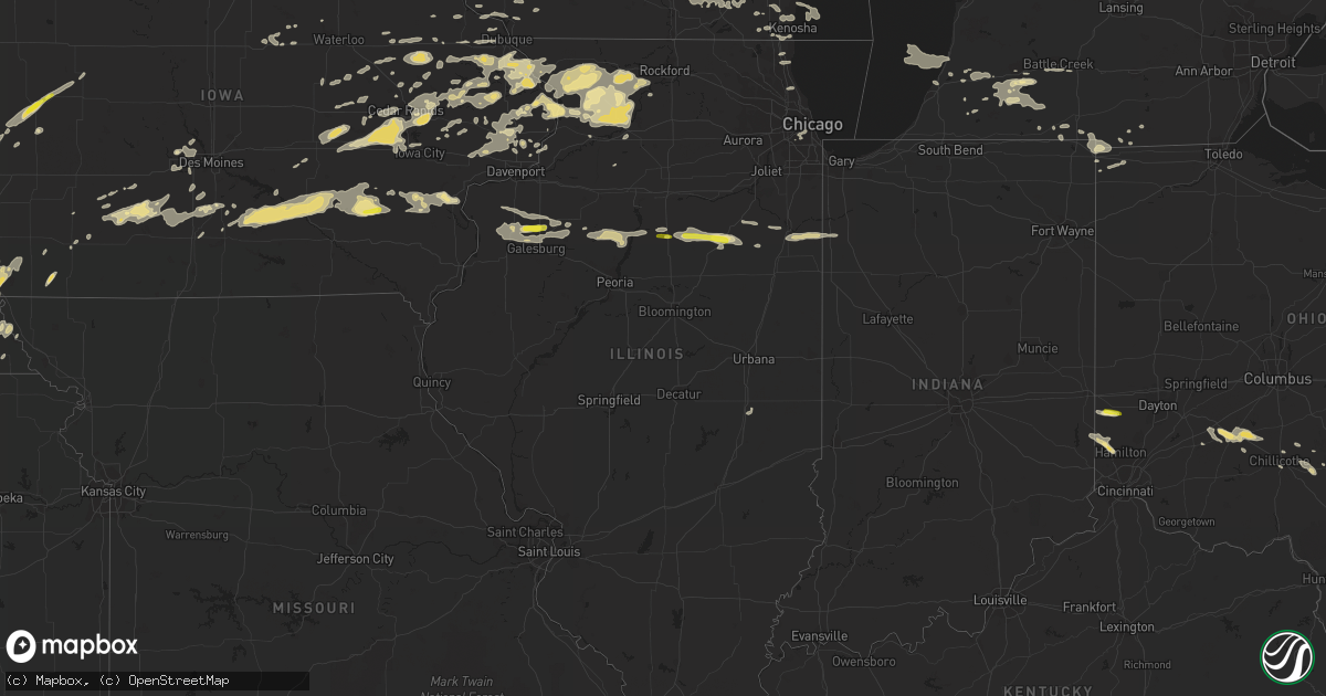
Hail Map in Illinois on May 13, 2018
Get this storm
May 13 map
$229
one time, instant access
Download today. No call, no setup
Keep the $229
Bought the map and want the full workflow? Apply the entire $229 to a subscription within 7 days. None of it is wasted.
Every map, not just this one
This buys you this map. Subscription and you get every map we run, in the markets you choose from a few cities to whole states to nationwide. Plus real-time alerts the moment a storm fires.
Contact data
Name, contact info, occupancy, even credit band for addresses in the footprint. You go from where it hit to who to call.
Become the source they trust
Unlimited branding weather history reports on demand. You already have the documented answer ready for the property owner, and you are the one who showed up with it.
Property data and RoofTrace estimates
Pull up any address you have got, its value and the exact code rules for that jurisdiction, straight from One Click Code. Then RoofTrace estimates the squares, pitch, and roof value, priced the way you price.
Storm reports in Illinois
Illinois
| Date | Description |
|---|---|
| 05/13/20186:00 PM CDT | Delayed report. Roof damage to the middle school... Caused by outflow boundary from storms in iroquois county. |
| 05/13/20185:43 PM CDT | Numerous large branches down... Including almost half a tree down in one |
| 05/13/20185:40 PM CDT | Power poles downed |
| 05/13/20185:15 PM CDT | Few reports of tree limbs down and one tree on car. |
| 05/13/20184:39 PM CDT | A local report indicates 1.00 inch wind near 1 SSW WENONA |
| 05/13/20183:31 PM CDT | A local report indicates 1.25 inch wind near 3 ESE RIO |
| 05/13/20183:25 PM CDT | Relayed by wfo dvn |
| 05/13/201812:01 AM CDT | At 501 PM CDT, severe thunderstorms were located along a line extending from 7 miles west of Dwight to near Odell to near Flanagan, moving east at 50 mph. HAZARD...60 mph wind gusts and quarter size hail. SOURCE...Radar indicated. IMPACT...Hail damage to vehicles is expected. Expect wind damage to roofs, siding, and trees. Severe thunderstorms will be near, Odell around 505 PM CDT. Dwight around 510 PM CDT. Cullom around 535 PM CDT. Other locations impacted by these severe thunderstorms includeCabery, Campus, Reddick, Saunemin, Kempton, Emington and Buckingham. |
| 05/12/201811:02 PM CDT | At 402 PM CDT, a severe thunderstorm was located over Camp Grove, or 13 miles west of Lacon, moving east at 25 mph. HAZARD...Quarter size hail. SOURCE...Radar indicated. IMPACT...Damage to vehicles is expected. Locations impacted include... Lacon, Henry, Wyoming, Toluca, Wenona, Bradford, Sparland, Varna, Castleton, Camp Grove, Hopewell, La Rose, Marshall County Airport, Lake Wildwood and Marshall-Putnam County Fairgrounds.This includes Interstate 39 between mile markers 30 and 40. |
| 05/12/201810:13 PM CDT | At 312 PM CDT, a severe thunderstorm was located over Rio, or 11 miles north of Galesburg, moving east at 35 mph. HAZARD...60 mph wind gusts and quarter size hail. SOURCE...Radar indicated. IMPACT...Hail damage to vehicles is expected. Expect wind damage to roofs, siding, and trees. Locations impacted include... Wataga, Oneida, Altona, Victoria, Rio, Henderson and Snake Den Hollow.This includes Interstate 74 between mile markers 34 and 44. |
All States Impacted by Hail Map on May 13, 2018
Cities Impacted by Hail Map on May 13, 2018
- Dodgeville, WI
- Spring Green, WI
- Schoenchen, KS
- Hays, KS
- La Crosse, KS
- McCracken, KS
- Gate, OK
- Meade, KS
- Englewood, KS
- Booker, TX
- Perryton, TX
- Balko, OK
- Haviland, KS
- Coloma, MI
- Watervliet, MI
- Covert, MI
- Hartford, MI
- Lawrence, MI
- Macksburg, IA
- Orient, IA
- Creston, IA
- Lorimor, IA
- Greenfield, IA
- Miami, TX
- Beaver, OK
- Spearman, TX
- Ely, IA
- Cedar Rapids, IA
- Mount Vernon, IA
- Keota, IA
- Ollie, IA
- Sigourney, IA
- Richland, IA
- Eaton, OH
- Quanah, TX
- Eldorado, OK
- Greenleaf, KS
- West Branch, IA
- Granger, IA
- Grimes, IA
- Kearney, NE
- Riverdale, NE
- Fowler, KS
- Memphis, TX
- Wellington, TX
- Hedley, TX
- Center Junction, IA
- Anamosa, IA
- Cambridge, MD
- Culpeper, VA
- Rhoadesville, VA
- Burr Hill, VA
- Locust Grove, VA
- Wyoming, IA
- Shenandoah, IA
- Coin, IA
- Clarinda, IA
- Minneapolis, KS
- Washington Court House, OH
- Shannon, IL
- Pearl City, IL
- Mount Carroll, IL
- Lanark, IL
- Childress, TX
- Shamrock, TX
- Wisner, NE
- Masonville, IA
- Ryan, IA
- Manchester, IA
- Bartley, NE
- Cambridge, NE
- Odell, IL
- Dwight, IL
- Mobeetie, TX
- Lincoln, KS
- Fairfax, IA
- Norway, IA
- Atkins, IA
- Palo, IA
- Newhall, IA
- Cabery, IL
- Indianola, IA
- New Virginia, IA
- Sidney, IA
- Chadwick, IL
- Morrison, IL
- Table Rock, NE
- Steinauer, NE
- Pawnee City, NE
- Elizabeth, CO
- Tell, TX
- Matador, TX
- Berkeley Springs, WV
- Hedgesville, WV
- Big Pool, MD
- Hancock, MD
- Hollandale, WI
- Wingate, MD
- Toddville, MD
- Turon, KS
- Alexandria, VA
- Accokeek, MD
- Clinton, MD
- Fort Washington, MD
- Logan, IA
- Briscoe, TX
- Wheeler, TX
- Canadian, TX
- Reydon, OK
- Lakeview, TX
- Turkey, TX
- Hamilton, IN
- Edon, OH
- Daphne, AL
- Ridott, IL
- Baileyville, IL
- German Valley, IL
- Leaf River, IL
- Freeport, IL
- Forreston, IL
- Pecatonica, IL
- Thomson, IL
- Offerle, KS
- Sparland, IL
- Speer, IL
- Bradford, IL
- Wyoming, IL
- Johnson, NE
- Elk Creek, NE
- Humboldt, NE
- Auburn, NE
- Arion, IA
- Dow City, IA
- Denison, IA
- Bussey, IA
- Columbia, IA
- Hamilton, IA
- Knoxville, IA
- Durango, IA
- Sherrill, IA
- Rowley, IA
- Walker, IA
- Brandon, IA
- Burr Oak, MI
- Sturgis, MI
- Grand Mound, IA
- Calamus, IA
- De Witt, IA
- Hoisington, KS
- Otis, KS
- Albert, KS
- Olmitz, KS
- Byron, IL
- Chebanse, IL
- Saint Anne, IL
- Pembroke Township, IL
- Morocco, IN
- Kankakee, IL
- Sawyer, KS
- Larned, KS
- Bronson, MI
- Orland, IN
- Burchard, NE
- Liberty, NE
- Brownville, NE
- Nemaha, NE
- Elizabeth, IL
- Stockton, IL
- Savanna, IL
- Kent, IL
- Arnett, OK
- Mineral Point, WI
- Rewey, WI
- Ellsworth, KS
- West Point, NE
- Bethesda, OH
- Mountain Park, OK
- Blair, OK
- Woodbine, IA
- Ainsworth, IA
- Red Oak, IA
- Defiance, IA
- Altus, OK
- Fairhope, AL
- Foley, AL
- Bazine, KS
- Laverne, OK
- Holbrook, NE
- Arapahoe, NE
- Wheatland, IA
- Deer Trail, CO
- Baldwin, IA
- Maquoketa, IA
- Fremont, NE
- Tescott, KS
- Beverly, KS
- Walnut, IL
- Polo, IL
- Barnard, KS
- Thornville, OH
- Rushville, OH
- Pleasantville, OH
- Stockport, OH
- Waterford, OH
- Vail, IA
- Percival, IA
- Nebraska City, NE
- Syracuse, NE
- Hamburg, IA
- Dunbar, NE
- Thurman, IA
- Talmage, NE
- Lorton, NE
- Palmer, KS
- Linn, KS
- Washington, NE
- Waterloo, NE
- Missouri Valley, IA
- Kennard, NE
- Fort Calhoun, NE
- Blair, NE
- Elkhorn, NE
- Bennington, NE
- Omaha, NE
- Valley, NE
- Yutan, NE
- Kiowa, CO
- Calhan, CO
- Agate, CO
- Elbert, CO
- Ramah, CO
- Pampa, TX
- Fontanelle, IA
- Bridgewater, IA
- Monticello, IA
- Dallas Center, IA
- Springfield, VA
- Oregon, WI
- Madison, WI
- Mcfarland, WI
- Defuniak Springs, FL
- Hosford, FL
- Bristol, FL
- Mangum, OK
- Quitaque, TX
- Paducah, TX
- Gould, OK
- Cee Vee, TX
- Letts, IA
- Duke, OK
- Higgins, TX
- Hartwick, IA
- Chelsea, IA
- Brooklyn, IA
- McCook, NE
- Indianola, NE
- Barnes, KS
- Kinsley, KS
- Lost Nation, IA
- Wenona, IL
- Miles, IA
- Bryant, IA
- Preston, IA
- Mahaska, KS
- Jamestown, OH
- Sabina, OH
- Schoolcraft, MI
- Delmar, IA
- Charlotte, IA
- Crawfordsville, IA
- Oxford, IA
- Middle Amana, IA
- Marengo, IA
- Swisher, IA
- South Amana, IA
- Homestead, IA
- Amana, IA
- Dixon, IL
- Hebron, NE
- Rozel, KS
- Milledgeville, IL
- Hopkinton, IA
- Rock Port, MO
- Fort Belvoir, VA
- Bryans Road, MD
- Brandywine, MD
- Alva, OK
- Oxford, OH
- Hamilton, OH
- Monmouth, IA
- Cook, NE
- Brock, NE
- Tecumseh, NE
- Elm Creek, NE
- Overton, NE
- Loomis, NE
- Bertrand, NE
- Adams, NE
- Cortland, NE
- Pickrell, NE
- Clay Center, KS
- Verona, WI
- Cross Plains, WI
- Curtis, NE
- Maywood, NE
- Danbury, NE
- Westville, FL
- Zwingle, IA
- Bellevue, IA
- Spragueville, IA
- La Motte, IA
- Hanover, IL
- Bernard, IA
- Barneveld, WI
- Franksville, WI
- Union Grove, WI
- Sturtevant, WI
- Salem, NE
- Winterset, IA
- Clarendon, TX
- Wymore, NE
- Oketo, KS
- Barneston, NE
- Marysville, KS
- Snyder, OK
- Mclean, TX
- Oneida, IL
- Aledo, IL
- Rio, IL
- North Henderson, IL
- Alexis, IL
- Franktown, CO
- Wilson, KS
- Dorrance, KS
- Shelbyville, IN
- Arlington, IN
- Morristown, IN
- Gwynneville, IN
- Ladora, IA
- Sylvan Grove, KS
- Mineral Wells, WV
- Bennington, KS
- Alexander, KS
- Stoughton, WI
- Edgerton, WI
- Clear Spring, MD
- Falling Waters, WV
- Needmore, PA
- Warfordsburg, PA
- Shorterville, AL
- Leonidas, MI
- Mendon, MI
- Colon, MI
- Jansen, NE
- Diller, NE
- Beatrice, NE
- Sterling, IL
- Woosung, IL
- Mount Morris, IL
- Oregon, IL
- Toulon, IL
- La Fayette, IL
- South Bloomingville, OH
- Vicksburg, MI
- Kalamazoo, MI
- Portage, MI
- Scotts, MI
- Wellsburg, IA
- Stockton, IA
- Alburnett, IA
- Marion, IA
- Central City, IA
- Fremont, IA
- New Sharon, IA
- Oskaloosa, IA
- Beacon, IA
- University Park, IA
- Chariton, IA
- Cedar, IA
- Eddyville, IA
- Lovilia, IA
- Rose Hill, IA
- Tracy, IA
- Lacona, IA
- West Chester, IA
- Washington, IA
- Walford, IA
- Williamsburg, IA
- Tiffin, IA
- Vinton, IA
- Mount Auburn, IA
- Columbus Junction, IA
- Miltonvale, KS
- Clinton, IA
- Sabula, IA
- Sterling, NE
- Burr, NE
- Harper, IA
- South English, IA
- Brighton, IA
- Webster, IA
- Hedrick, IA
- Eustis, NE
- Moorefield, NE
- Kansasville, WI
- Burlington, WI
- Lorton, VA
- Waldorf, MD
- Ridgeway, WI
- Paw Paw, MI
- Center Point, IA
- South Haven, MI
- Morrowville, KS
- Bunker Hill, KS
- Greensburg, KS
- Ackley, IA
- Aplington, IA
- Holland, IA
- Parkersburg, IA
- Osseo, MI
- Camden, MI
- Hillsdale, MI
- Galva, IL
- Wataga, IL
- Victoria, IL
- Henderson, IL
- Monmouth, IL
- Little York, IL
- Galesburg, IL
- Altona, IL
- Gerlaw, IL
- Dawson, NE
- Winnebago, IL
- Hollenberg, KS
- Loxley, AL
- Fairbury, NE
- Plymouth, NE
- Steele City, NE
- Endicott, NE
- De Witt, NE
- Lipscomb, TX
- Follett, TX
- Sperryville, VA
- Durant, IA
- Walcott, IA
- New Liberty, IA
- Auburn, IA
- McCausland, IA
- Camanche, IA
- Manilla, IA
- Irwin, IA
- Delphos, KS
- Long Grove, IA
- Eldridge, IA
- Elkhorn, WI
- Fort Atkinson, WI
- Delavan, WI
- Milton, WI
- East Troy, WI
- Whitewater, WI
- Leighton, IA
- What Cheer, IA
- Melcher Dallas, IA
- Hayesville, IA
- Russell, IA
- Harvey, IA
- Delta, IA
- West College Corner, IN
- Bath, IN
- Liberty, IN
- Cascade, IA
- Lowden, IA
- Clarence, IA
- Oakland, NE
- Springville, IA
- Martelle, IA
- Dowagiac, MI
- Cassopolis, MI
- Mechanicsville, IA
- Lisbon, IA
- Stanwood, IA
- Tipton, IA
- Protection, KS
- Ashland, KS
- Pittsford, MI
- New Holland, OH
- Clarksburg, OH
- Belle Plaine, IA
- Le Claire, IA
- Farley, IA
- Epworth, IA
- Onslow, IA
- Peosta, IA
- North Liberty, IA
- Galena, IL
- Solon, IA
- Morley, IA
- Olin, IA
- Victor, IA
- Andrew, IA
- Oxford Junction, IA
- Conroy, IA
- Dubuque, IA
- Guernsey, IA
- Worthington, IA
- Libertyville, IL
- Waukegan, IL
- North Chicago, IL
- Decatur, NE
- Tekamah, NE
- Brownell, KS
- Catharine, KS
- Plainville, KS
- Ellis, KS
- Florala, AL
- Claflin, KS
- Alton, KS
- Massena, IA
- Anita, IA
- Georgetown, DE
- Seaford, DE
- Laurel, DE
- Ancona, IL
- Streator, IL
- Cornell, IL
- Blackstone, IL
- Emington, IL
- Toddville, IA
- Londonderry, OH
- Ray, OH
- Bison, KS
- Coggon, IA
- Clearville, PA
- Artemas, PA
- Roosevelt, OK
- Olustee, OK
- Headrick, OK
- Modale, IA
- Climax, MI
- Battle Creek, MI
- Angola, IN
- Montpelier, OH
- Fremont, IN
- Pioneer, OH
- Montgomery, MI
- Gill, CO
- Kersey, CO
- Greeley, CO
- La Salle, CO
- Evans, CO
- Briggsdale, CO
- Rush Center, KS
- Deerfield, WI
- Cambridge, WI
- Pilger, NE
- Bristol, WI
- Steamboat Rock, IA
- Saint Charles, IA
- Rixeyville, VA
- Castleton, VA
- Three Rivers, MI
- Marcellus, MI
- Albany, OH
- Woodville, VA
- Traer, IA
- Independence, IA
- Fulton, IL
- Cassville, WI
- Potosi, WI
- Holy Cross, IA
- Iowa City, IA
- Coralville, IA
- Bedford, PA
- Daleville, AL
- Keystone, IA
- Elberon, IA
- Russell, KS
- Long Point, IL
- Dana, IL
- Villisca, IA
- Teeds Grove, IA
- Cottage Grove, WI
- Gurnee, IL
- Dixon, IA
- Goose Lake, IA
- Wilton, IA
- Donahue, IA
- Bennett, IA
- Guttenberg, IA
- Colesburg, IA
- Rochester, IN
- Menlo, IA
- Greenfield, OH
- Belleville, KS
- Chester, NE
- Scandia, KS
- Republic, KS
- Reddick, IL
- Gardner, IL
- Wilmington, OH
- Yorktown, IA
- Hanover, KS
- Bremen, KS
- Minneola, KS
- Freedom, OK
- Honey Creek, IA
- Dyersville, IA
- Fairfax, MO
- Hudson, CO
- Keenesburg, CO
- Bennett, CO
- Westside, IA
- Arcadia, IA
- Dunlap, IA
- Breda, IA
- Mount Horeb, WI
- Wapello, IA
- Conesville, IA
- Waukee, IA
- Chicago, IL
- Craig, NE
- Arlington, NE
- Randolph, IA
- Axtell, KS
- Tabor, IA
- Peru, NE
- Baileyville, KS
- Farragut, IA
- Imogene, IA
- Helenville, WI
- Jefferson, WI
- Lucas, IA
- Coden, AL
- Theodore, AL
- Irvington, AL
- Watkins, IA
- Blairstown, IA
- Sullivan, WI
- Rushville, IN
- Fountaintown, IN
- Searsboro, IA
- Lynnville, IA
- Luray, KS
- Lucas, KS
- Chillicothe, OH
- Alexandria, NE
- Edgewood, IA
- Winamac, IN
- Kewanna, IN
- Filley, NE
- Crab Orchard, NE
- Odell, NE
- Douglas, NE
- Hudson, MI
- Amesville, OH
- Boulder, CO
- Silver Lake, WI
- Salem, WI
- Princess Anne, MD
- Eden, MD
- Firth, NE
- Green, KS
- Platteville, WI
- Glouster, OH
- Dysart, IA
- Decatur, MI
- Franklin, WI
- Greendale, WI
- Ness City, KS
- Courtland, KS
- Elkwood, VA
- Sumerduck, VA
- Remington, VA
- Brandy Station, VA
- Amissville, VA
- Lyons, NE
- Cordova, IL
- Princeton, IA
- Oconomowoc, WI
- Delafield, WI
- Wales, WI
- Dousman, WI
- Waukesha, WI
- Shattuck, OK
- West Unity, OH
- Earlville, IA
- Delhi, IA
- Beemer, NE
- Snow Hill, MD
- Coldwater, MI
- Reading, MI
- Prole, IA
- Norwalk, IA
- Cuba City, WI
- Concordia, KS
- Northbrook, IL
- Waldron, MI
- Buffalo, OK
- Corning, IA
- Carbon, IA
- Lacon, IL
- Varna, IL
- Henry, IL
- Chillicothe, IL
- Quaker City, OH
- Barnesville, OH
- Everett, PA
- Salisbury, MD
- Parsonsburg, MD
- Clatonia, NE
- Milo, IA
- Belmont, WI
- Bangor, MI
- Waterloo, WI
- Mcconnelsville, OH
- Malta, OH
- Panama, IA
- Van Horne, IA
- Kenosha, WI
- Racine, WI
- Flomot, TX
- Clive, IA
- Johnston, IA
- Urbandale, IA
- Muscatine, IA
- Grandview, IA
- Stockville, NE
- Cumming, IA
- West Des Moines, IA
- Reynolds, IL
- Viola, IL
- Alpha, IL
- Woodhull, IL
- New Windsor, IL
- Elwood, NE
- Smithfield, NE
- Verdon, NE
- Clifton, KS
- Osceola, IA
- Elmwood, NE
- Murdock, NE
- Millersburg, IN
- Buffalo Mills, PA
- Prairieburg, IA
- Rutland, IL
- Gilead, NE
- Winthrop, IA
- Logan, OH
- Benton Harbor, MI
- Indianapolis, IN
- Fairland, IN
- McArthur, OH
- Forgan, OK
- Plains, KS
- Bethel, DE
- Camden, OH
- West Alexandria, OH
- Stillman Valley, IL
- Magnolia, IL
- Tuscola, IL
- Arcola, IL
- Adel, IA
- De Soto, IA
- Van Meter, IA
- Eglin Afb, FL
- Ceresco, MI
- Pella, IA
- Bonfield, IL
- Morganville, KS
- Aurora, KS
- Natoma, KS
- Manns Choice, PA
- Schellsburg, PA
- Pleasant Prairie, WI
- Zion, IL
- Lake Mills, WI
- Grinnell, IA
- Kingston, OH
- Laurelville, OH
- Janesville, IA
- Muskego, WI
- Big Bend, WI
- Malcom, IA
- Prescott, IA
- Truro, IA
- Peru, IA
- Murray, IA
- Crescent, IA
- Mondamin, IA
- Magnolia, IA
- Neola, IA
- Griswold, IA
- Glen Haven, WI
- Lawton, MI
- Mattawan, MI
- Beloit, KS
- Blue Mounds, WI
- Ponce De Leon, FL
- Waterford, WI
- Eagle, WI
- Mukwonago, WI
- Annandale, VA
- Fairfax, VA
- Oxon Hill, MD
- Coldwater, KS
- Oak Creek, WI
- New Lexington, OH
- Shawnee, OH
- Stuart, IA
- Union, NE
- Central City, PA
- Stoystown, PA
- La Porte City, IA
- Gorham, KS
- Lewis, KS
- Liebenthal, KS
- Garfield, KS
- Woodrow, CO
- Colorado Springs, CO
- Somerset, OH
- Caldwell, OH
- Cumberland, OH
- Lignum, VA
- Toluca, IL


