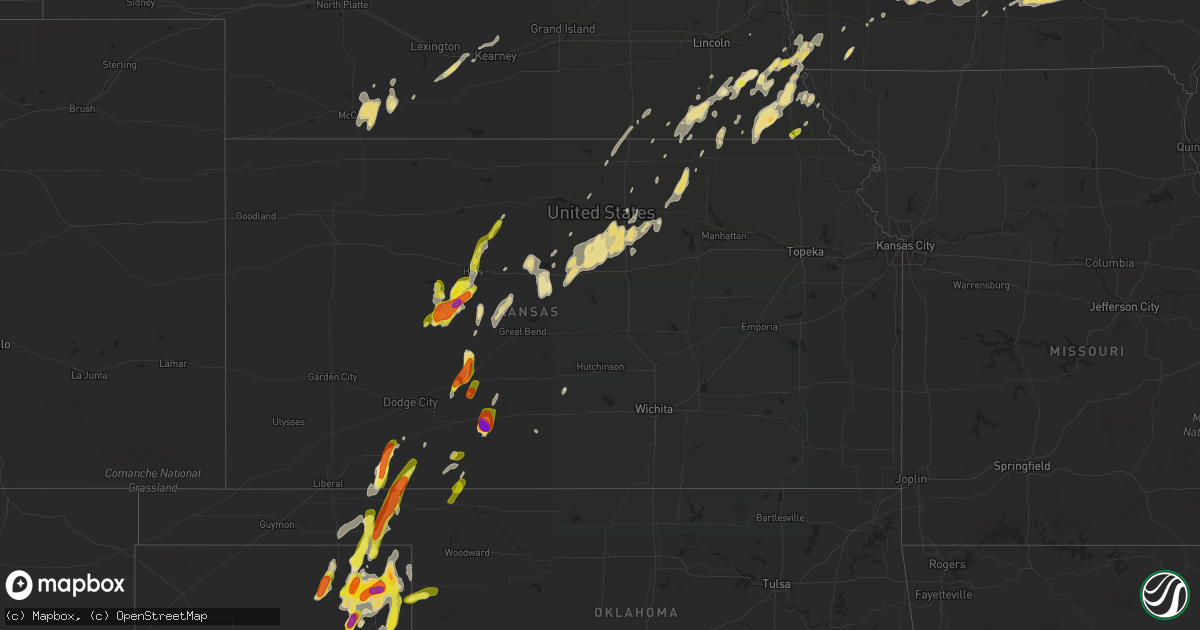
Hail Map in Kansas on May 13, 2018
Get this storm
May 13 map
$229
one time, instant access
Download today. No call, no setup
Keep the $229
Bought the map and want the full workflow? Apply the entire $229 to a subscription within 7 days. None of it is wasted.
Every map, not just this one
This buys you this map. Subscription and you get every map we run, in the markets you choose from a few cities to whole states to nationwide. Plus real-time alerts the moment a storm fires.
Contact data
Name, contact info, occupancy, even credit band for addresses in the footprint. You go from where it hit to who to call.
Become the source they trust
Unlimited branding weather history reports on demand. You already have the documented answer ready for the property owner, and you are the one who showed up with it.
Property data and RoofTrace estimates
Pull up any address you have got, its value and the exact code rules for that jurisdiction, straight from One Click Code. Then RoofTrace estimates the squares, pitch, and roof value, priced the way you price.
Storm reports in Kansas
Kansas
| Date | Description |
|---|---|
| 05/13/20186:15 PM CDT | 1 inch reported from ict. |
| 05/13/20185:55 PM CDT | 3.5 inch exact size reported by kake. |
| 05/13/20185:25 PM CDT | Delayed report mesonet site lcuk1. |
| 05/13/20186:56 AM CDT | At 1156 PM CDT, severe thunderstorms were located along a line extending from 6 miles north of Wells to near New Cambria to near Lindsborg, moving east at 45 mph. HAZARD...70 mph wind gusts and nickel size hail. SOURCE...Radar indicated. IMPACT...Expect considerable tree damage. Damage is likely to mobile homes, roofs, and outbuildings. Locations impacted include... Junction City, Abilene, Herington, Ogden, Grandview Plaza, Chapman, Solomon, Wakefield, Riley, Enterprise, Milford, Leonardville, Hope, Woodbine, Wells, Manchester, Longford, Carlton, Oak Hill and Latimer.This includes Interstate 70 between mile markers 267 and 306. |
| 05/13/20186:18 AM CDT | At 1117 PM CDT, a severe thunderstorm was located very near Antonino, moving northeast at 5 mph. HAZARD...60 mph wind gusts and quarter size hail. SOURCE...Radar indicated. IMPACT...Hail damage to vehicles is expected. Expect wind damage to roofs, siding, and trees. Locations impacted include... Hays, Victoria, Walker, Catherine, Yocemento, Toulon, Munjor and Antonino. |
| 05/13/20185:36 AM CDT | At 1036 PM CDT, a severe thunderstorm was located over Tescott, moving north at 30 mph. HAZARD...Ping pong ball size hail and 60 mph wind gusts. SOURCE...Radar indicated. IMPACT...People and animals outdoors will be injured. Expect hail damage to roofs, siding, windows, and vehicles. Expect wind damage to roofs, siding, and trees. Locations impacted include... Minneapolis, Glasco, Delphos, Tescott and Ada. |
| 05/13/20185:29 AM CDT | At 1029 PM CDT, a severe thunderstorm was located Southwest of Antonio, moving northeast at 35 mph. This warning will replace the expiring warning. HAZARD...Two inch hail and 60 mph wind gusts. SOURCE...Radar indicated. IMPACT...People and animals outdoors will be injured. Expect hail damage to roofs, siding, windows, and vehicles. Expect wind damage to roofs, siding, and trees. Locations impacted include... Hays, Ellis, Victoria, Walker, Catherine, Schoenchen, Liebenthal, Emmeram, Yocemento, Munjor, Loretta, Riga, Pfeifer, Toulon and Antonino. |
| 05/13/20185:05 AM CDT | At 1005 PM CDT, a severe thunderstorm was located 6 miles south of Plevna, or 11 miles east of Neola, moving north at 30 mph. HAZARD...Ping pong ball size hail and 60 mph wind gusts. SOURCE...Radar indicated. IMPACT...People and animals outdoors will be injured. Expect hail damage to roofs, siding, windows, and vehicles. Expect wind damage to roofs, siding, and trees. Locations impacted include... Nickerson, Arlington, Partridge, Plevna, Abbyville, Willowbrook and Langdon. |
| 05/13/20184:58 AM CDT | At 958 PM CDT, a severe thunderstorm was located near Milberger, or 10 miles northeast of Otis, moving northeast at 40 mph. HAZARD...60 mph wind gusts and half dollar size hail. SOURCE...Radar indicated. IMPACT...Hail damage to vehicles is expected. Expect wind damage to roofs, siding, and trees. Locations impacted include... Russell, Lucas, Gorham, Sylvan Grove, Luray, Dorrance, Olmitz, Milberger, Bunker Hill, Paradise, Galatia, Susank, Waldo, Russell Airport, Wilson State Park and Wilson Lake.This includes Interstate 70 between Mile Markers 176 and 202. |
| 05/13/20184:42 AM CDT | At 940 PM CDT, a severe thunderstorm was located 7 miles west of Antonino, moving northeast at 35 mph. This warning replaces the expiring warning. HAZARD...Two inch hail and 70 mph wind gusts. SOURCE...Radar indicated. IMPACT...People and animals outdoors will be injured. Expect hail damage to roofs, siding, windows, and vehicles. Expect considerable tree damage. Wind damage is also likely to mobile homes, roofs, and outbuildings. Locations impacted include... Hays, Ellis, La Crosse, Victoria, Walker, Catherine, Otis, Bison, Schoenchen, McCracken, Ogallah, Rush Center, Liebenthal, Timken, Emmeram, Yocemento, Hargrave, Riga, Pfeifer and Shaffer. |
| 05/13/20184:02 AM CDT | At 901 PM CDT, severe thunderstorms were located along a line extending from 4 miles south of Croft to 7 miles south of Aetna, moving east at 25 mph. HAZARD...70 mph wind gusts and quarter size hail. SOURCE...Radar indicated. IMPACT...Hail damage to vehicles is expected. Expect considerable tree damage. Wind damage is also likely to mobile homes, roofs, and outbuildings. Locations impacted include... Medicine Lodge, Kiowa, Hardtner, Sharon, Sawyer, Hazelton, Isabel, Coats, Lake City, Sun City, Aetna, Croft and Belvidere. |
| 05/13/20183:59 AM CDT | At 859 PM CDT, a severe thunderstorm was located 5 miles east of Brownell, moving north at 35 mph. This replaces the expiring warning. HAZARD...Two inch hail and 70 mph wind gusts. SOURCE...Radar indicated. IMPACT...People and animals outdoors will be injured. Expect hail damage to roofs, siding, windows, and vehicles. Expect considerable tree damage. Wind damage is also likely to mobile homes, roofs, and outbuildings. Locations impacted include... Hays, Ellis, La Crosse, Victoria, Walker, Catherine, Schoenchen, McCracken, Liebenthal, Brownell, Emmeram, Yocemento, Cedar Bluff, Munjor, Loretta, Hargrave, Riga, Pfeifer, Toulon and Antonino. |
| 05/13/20183:57 AM CDT | At 857 PM CDT, a severe thunderstorm was located 11 miles north of Freedom, moving northeast at 15 mph. HAZARD...60 mph wind gusts and quarter size hail. SOURCE...Radar indicated. IMPACT...Hail damage to vehicles is expected. Expect wind damage to roofs, siding, and trees. This severe thunderstorm will remain over mainly rural areas of north central Woods County. |
| 05/13/20183:56 AM CDT | At 856 PM CDT, a severe thunderstorm was located 6 miles west of Garfield, moving northeast at 25 mph. HAZARD...Golf ball size hail and 70 mph wind gusts. SOURCE...Radar indicated. IMPACT...People and animals outdoors will be injured. Expect hail damage to roofs, siding, windows, and vehicles. Expect considerable tree damage. Wind damage is also likely to mobile homes, roofs, and outbuildings. Locations impacted include... Larned, Garfield, Rozel, Ash Valley, Sanford and Frizell. |
| 05/13/20183:35 AM CDT | At 834 PM CDT, a severe thunderstorm was located near Codell, or 12 miles northwest of Emmeram, moving northeast at 40 mph. HAZARD...Half dollar size hail. SOURCE...Radar indicated. IMPACT...Damage to vehicles is expected. Locations impacted include... Plainville, Natoma, Woodston, Alton and Codell. |
| 05/13/20183:33 AM CDT | At 833 PM CDT, a severe thunderstorm was located near Offerle, moving east at 30 mph. HAZARD...Golf ball size hail and 60 mph wind gusts. SOURCE...Radar indicated. IMPACT...People and animals outdoors will be injured. Expect hail damage to roofs, siding, windows, and vehicles. Expect wind damage to roofs, siding, and trees. Locations impacted include... Kinsley, Lewis, Offerle, Garfield, Belpre and Sanford. |
| 05/13/20183:26 AM CDT | At 826 PM CDT, a severe thunderstorm was located 9 miles north of Coldwater, moving east at 25 mph. HAZARD...70 mph wind gusts and quarter size hail. SOURCE...Radar indicated. IMPACT...Hail damage to vehicles is expected. Expect considerable tree damage. Wind damage is also likely to mobile homes, roofs, and outbuildings. Locations impacted include... Greensburg, Wilmore and Belvidere. |
| 05/13/20183:23 AM CDT | At 823 PM CDT, a severe thunderstorm was located 5 miles northwest of Catherine, moving northeast at 35 mph. HAZARD...60 mph wind gusts and quarter size hail. SOURCE...Radar indicated. IMPACT...Hail damage to vehicles is expected. Expect wind damage to roofs, siding, and trees. Locations impacted include... Victoria, Catherine and Emmeram. |
| 05/13/20183:09 AM CDT | At 809 PM CDT, a severe thunderstorm was located near McCracken, moving northeast at 35 mph. This warning replaces the two previous warnings. HAZARD...Tennis ball size hail and 70 mph wind gusts. SOURCE...Radar indicated. IMPACT...People and animals outdoors will be injured. Expect hail damage to roofs, siding, windows, and vehicles. Expect considerable tree damage. Wind damage is also likely to mobile homes, roofs, and outbuildings. Locations impacted include... Hays, Ellis, La Crosse, Victoria, Walker, Catherine, Bison, Schoenchen, McCracken, Rush Center, Liebenthal, Alexander, Brownell, Yocemento, Cedar Bluff, Munjor, Loretta, Nekoma, Hargrave and Riga. |
| 05/13/20183:05 AM CDT | At 804 PM CDT, a severe thunderstorm was located very near Protection, moving east at 35 mph. HAZARD...70 mph wind gusts and quarter size hail. SOURCE...Radar indicated. IMPACT...Hail damage to vehicles is expected. Expect considerable tree damage. Wind damage is also likely to mobile homes, roofs, and outbuildings. Locations impacted include... Coldwater, Protection, Wilmore, Lake Coldwater and Buttermilk. |
| 05/13/20182:36 AM CDT | At 735 PM CDT, a severe thunderstorm was located 6 miles southwest of Verdon, or 9 miles west of Falls City, moving northeast at 30 mph. HAZARD...Quarter size hail. SOURCE...Radar indicated. IMPACT...Damage to vehicles is expected. Locations impacted include... Falls City, Verdon, Stella, Rulo, Dawson, Salem, Preston and The Highway 75 And 8 Junction.This includes Highway 75 in Nebraska between mile markers 1 and 10. |
| 05/13/20182:35 AM CDT | At 735 PM CDT, a severe thunderstorm was located near Ness City, moving north at 20 mph. HAZARD...Two inch hail and 70 mph wind gusts. SOURCE...Radar indicated. IMPACT...People and animals outdoors will be injured. Expect hail damage to roofs, siding, windows, and vehicles. Expect considerable tree damage. Wind damage is also likely to mobile homes, roofs, and outbuildings. Locations impacted include... Ness City, Ransom, Brownell and Cedar Bluff. |
| 05/13/20182:33 AM CDT | At 733 PM CDT, a severe thunderstorm was located very near Fowler, moving northeast at 35 mph. HAZARD...Golf ball size hail and 60 mph wind gusts. SOURCE...Radar indicated. IMPACT...People and animals outdoors will be injured. Expect hail damage to roofs, siding, windows, and vehicles. Expect wind damage to roofs, siding, and trees. Locations impacted include... Minneola and Fowler. |
| 05/13/20182:24 AM CDT | At 723 PM CDT, a severe thunderstorm was located near Laverne, moving northeast at 30 mph. HAZARD...70 mph wind gusts and quarter size hail. SOURCE...Radar indicated. IMPACT...Hail damage to vehicles is expected. Expect considerable tree damage. Wind damage is also likely to mobile homes, roofs, and outbuildings. Locations impacted include... Laverne, Buffalo, May and Rosston. |
| 05/13/20182:21 AM CDT | At 721 PM CDT, a severe thunderstorm was located 3 miles east of Bazine, moving northeast at 25 mph. HAZARD...Two inch hail and 70 mph wind gusts. SOURCE...Radar indicated. IMPACT...People and animals outdoors will be injured. Expect hail damage to roofs, siding, windows, and vehicles. Expect considerable tree damage. Wind damage is also likely to mobile homes, roofs, and outbuildings. Locations impacted include... La Crosse, Bazine, Schoenchen, McCracken, Liebenthal, Alexander, Loretta, Nekoma and Hargrave. |
| 05/13/20182:14 AM CDT | At 713 PM CDT, a severe thunderstorm was located 6 miles southeast of Meade, moving northeast at 30 mph. HAZARD...Two inch hail and 70 mph wind gusts. SOURCE...Radar indicated. IMPACT...People and animals outdoors will be injured. Expect hail damage to roofs, siding, windows, and vehicles. Expect considerable tree damage. Wind damage is also likely to mobile homes, roofs, and outbuildings. Locations impacted include... Meade and Fowler. |
| 05/13/20182:09 AM CDT | At 707 PM CDT, a severe thunderstorm was located 4 miles northwest of Clark State Lake, moving north at 25 mph. HAZARD...60 mph wind gusts and quarter size hail. SOURCE...Radar indicated. IMPACT...Hail damage to vehicles is expected. Expect wind damage to roofs, siding, and trees. Locations impacted include... Ford, Bloom, Clark State Lake and Kingsdown. |
| 05/13/20182:00 AM CDT | At 700 PM CDT, a severe thunderstorm was located 5 miles west of Centerview, moving north at 20 mph. HAZARD...60 mph wind gusts and quarter size hail. SOURCE...Radar indicated. IMPACT...Hail damage to vehicles is expected. Expect wind damage to roofs, siding, and trees. Locations impacted include... Kinsley, Lewis, Garfield and Centerview. |
| 05/13/20181:21 AM CDT | At 621 PM CDT, a severe thunderstorm was located 7 miles west of Acres, moving northeast at 30 mph. HAZARD...60 mph wind gusts and quarter size hail. SOURCE...Radar indicated. IMPACT...Hail damage to vehicles is expected. Expect wind damage to roofs, siding, and trees. Locations impacted include... Ashland, Englewood and Acres. |
| 05/13/20181:18 AM CDT | At 616 PM CDT, a severe thunderstorm was located very near Trousdale, moving north at 30 mph. This warning will be replacing the previous thunderstorm warning that was issued for Kiowa County to account for both storms. This is a very dangerous storm. HAZARD...Three inch hail and 70 mph wind gusts. SOURCE...Radar indicated. IMPACT...People and animals outdoors will be severely injured. Expect shattered windows, extensive damage to roofs, siding, and vehicles. Locations impacted include... Haviland, Macksville, Belpre, Fellsburg, Hopewell, Wellsford, Zook, Trousdale and Dillwyn. |
| 05/13/201812:53 AM CDT | At 552 PM CDT, a severe thunderstorm was located over Bryans Corner, or 15 miles north of Perryton, moving northeast at 30 mph. HAZARD...60 mph wind gusts and quarter size hail. SOURCE...Radar indicated. IMPACT...Minor damage to roofs, siding, and trees is possible. Hail damage to vehicles is expected. Locations impacted include... Beaver, Forgan, Bryans Corner, Boyd, Mocane, Floris and Balko. |
| 05/13/201812:50 AM CDT | At 550 PM CDT, a severe thunderstorm was located 6 miles southeast of Greensburg, moving north at 25 mph. HAZARD...Two inch hail and 70 mph wind gusts. SOURCE...Radar indicated. IMPACT...People and animals outdoors will be injured. Expect hail damage to roofs, siding, windows, and vehicles. Expect considerable tree damage. Wind damage is also likely to mobile homes, roofs, and outbuildings. Locations impacted include... Greensburg, Haviland, Fellsburg, Hopewell, Centerview, Wellsford and Trousdale. |
| 05/13/201812:45 AM CDT | At 544 PM CDT, a severe thunderstorm was located very near Knowles, or 16 miles southwest of Englewood, moving northeast at 25 mph. HAZARD...Two inch hail and 70 mph wind gusts. SOURCE...Radar indicated. IMPACT...People and animals outdoors will be injured. Expect hail damage to roofs, siding, windows, and vehicles. Expect considerable tree damage. Wind damage is also likely to mobile homes, roofs, and outbuildings. Locations impacted include... Englewood and Acres. |
| 05/13/201812:22 AM CDT | At 522 PM CDT, a severe thunderstorm was located 4 miles west of Belvidere, moving northeast at 35 mph. HAZARD...Two inch hail and 70 mph wind gusts. SOURCE...Radar indicated. IMPACT...People and animals outdoors will be injured. Expect hail damage to roofs, siding, windows, and vehicles. Expect considerable tree damage. Wind damage is also likely to mobile homes, roofs, and outbuildings. Locations impacted include... Pratt, Haviland, Cullison, Wellsford, Croft, Trousdale and Belvidere. |
| 05/13/201812:17 AM CDT | At 517 PM CDT, a severe thunderstorm was located 4 miles southeast of Protection, moving northeast at 25 mph. HAZARD...Two inch hail and 70 mph wind gusts. SOURCE...Radar indicated. IMPACT...People and animals outdoors will be injured. Expect hail damage to roofs, siding, windows, and vehicles. Expect considerable tree damage. Wind damage is also likely to mobile homes, roofs, and outbuildings. Locations impacted include... Coldwater, Protection, Wilmore and Lake Coldwater. |
| 05/12/201811:54 PM CDT | A local report indicates 63 MPH wind near SALINA AIRPORT |
| 05/12/201811:36 PM CDT | At 436 PM CDT, a severe thunderstorm was located near Buffalo, moving northeast at 25 mph. HAZARD...Ping pong ball size hail and 60 mph wind gusts. SOURCE...Radar indicated. IMPACT...People and animals outdoors will be injured. Expect hail damage to roofs, siding, windows, and vehicles. Expect wind damage to roofs, siding, and trees. Locations impacted include... Buffalo. |
| 05/12/201811:05 PM CDT | A local report indicates 1.00 inch wind near 4 SW ANTONINO |
| 05/12/201810:00 PM CDT | A local report indicates 1.00 inch wind near 1 E SCHOENCHEN |
| 05/12/20189:20 PM CDT | Estimated 2 inch reported from kody in mccracken through kwch. |
| 05/12/20189:10 PM CDT | Quarter size. |
| 05/12/20189:05 PM CDT | Golfball size hail reported a few miles east on the mccracken blacktop. |
| 05/12/20189:00 PM CDT | A few hail stones fell the size of quarters. |
| 05/12/20189:00 PM CDT | Ping pong size. |
| 05/12/20188:30 PM CDT | Derrick unreid storm chaser. |
| 05/12/20188:29 PM CDT | Reported at autumn lane hays... Ks. |
| 05/12/20188:18 PM CDT | Quarter size. |
| 05/12/20188:15 PM CDT | Quarter size. |
| 05/12/20187:50 PM CDT | Quarter size. |
| 05/12/20187:50 PM CDT | Half dollar size. |
| 05/12/20187:36 PM CDT | A local report indicates 1.50 inch wind near 5 SE MEADE STATE PARK |
| 05/12/20187:20 PM CDT | A local report indicates 1.75 inch wind near 5 E MEADE STATE PARK |
| 05/12/20187:10 PM CDT | Ping pong size. |
| 05/12/20187:10 PM CDT | Quarter size. |
All States Impacted by Hail Map on May 13, 2018
Cities Impacted by Hail Map on May 13, 2018
- Dodgeville, WI
- Spring Green, WI
- Schoenchen, KS
- Hays, KS
- La Crosse, KS
- McCracken, KS
- Gate, OK
- Meade, KS
- Englewood, KS
- Booker, TX
- Perryton, TX
- Balko, OK
- Haviland, KS
- Coloma, MI
- Watervliet, MI
- Covert, MI
- Hartford, MI
- Lawrence, MI
- Macksburg, IA
- Orient, IA
- Creston, IA
- Lorimor, IA
- Greenfield, IA
- Miami, TX
- Beaver, OK
- Spearman, TX
- Ely, IA
- Cedar Rapids, IA
- Mount Vernon, IA
- Keota, IA
- Ollie, IA
- Sigourney, IA
- Richland, IA
- Eaton, OH
- Quanah, TX
- Eldorado, OK
- Greenleaf, KS
- West Branch, IA
- Granger, IA
- Grimes, IA
- Kearney, NE
- Riverdale, NE
- Fowler, KS
- Memphis, TX
- Wellington, TX
- Hedley, TX
- Center Junction, IA
- Anamosa, IA
- Cambridge, MD
- Culpeper, VA
- Rhoadesville, VA
- Burr Hill, VA
- Locust Grove, VA
- Wyoming, IA
- Shenandoah, IA
- Coin, IA
- Clarinda, IA
- Minneapolis, KS
- Washington Court House, OH
- Shannon, IL
- Pearl City, IL
- Mount Carroll, IL
- Lanark, IL
- Childress, TX
- Shamrock, TX
- Wisner, NE
- Masonville, IA
- Ryan, IA
- Manchester, IA
- Bartley, NE
- Cambridge, NE
- Odell, IL
- Dwight, IL
- Mobeetie, TX
- Lincoln, KS
- Fairfax, IA
- Norway, IA
- Atkins, IA
- Palo, IA
- Newhall, IA
- Cabery, IL
- Indianola, IA
- New Virginia, IA
- Sidney, IA
- Chadwick, IL
- Morrison, IL
- Table Rock, NE
- Steinauer, NE
- Pawnee City, NE
- Elizabeth, CO
- Tell, TX
- Matador, TX
- Berkeley Springs, WV
- Hedgesville, WV
- Big Pool, MD
- Hancock, MD
- Hollandale, WI
- Wingate, MD
- Toddville, MD
- Turon, KS
- Alexandria, VA
- Accokeek, MD
- Clinton, MD
- Fort Washington, MD
- Logan, IA
- Briscoe, TX
- Wheeler, TX
- Canadian, TX
- Reydon, OK
- Lakeview, TX
- Turkey, TX
- Hamilton, IN
- Edon, OH
- Daphne, AL
- Ridott, IL
- Baileyville, IL
- German Valley, IL
- Leaf River, IL
- Freeport, IL
- Forreston, IL
- Pecatonica, IL
- Thomson, IL
- Offerle, KS
- Sparland, IL
- Speer, IL
- Bradford, IL
- Wyoming, IL
- Johnson, NE
- Elk Creek, NE
- Humboldt, NE
- Auburn, NE
- Arion, IA
- Dow City, IA
- Denison, IA
- Bussey, IA
- Columbia, IA
- Hamilton, IA
- Knoxville, IA
- Durango, IA
- Sherrill, IA
- Rowley, IA
- Walker, IA
- Brandon, IA
- Burr Oak, MI
- Sturgis, MI
- Grand Mound, IA
- Calamus, IA
- De Witt, IA
- Hoisington, KS
- Otis, KS
- Albert, KS
- Olmitz, KS
- Byron, IL
- Chebanse, IL
- Saint Anne, IL
- Pembroke Township, IL
- Morocco, IN
- Kankakee, IL
- Sawyer, KS
- Larned, KS
- Bronson, MI
- Orland, IN
- Burchard, NE
- Liberty, NE
- Brownville, NE
- Nemaha, NE
- Elizabeth, IL
- Stockton, IL
- Savanna, IL
- Kent, IL
- Arnett, OK
- Mineral Point, WI
- Rewey, WI
- Ellsworth, KS
- West Point, NE
- Bethesda, OH
- Mountain Park, OK
- Blair, OK
- Woodbine, IA
- Ainsworth, IA
- Red Oak, IA
- Defiance, IA
- Altus, OK
- Fairhope, AL
- Foley, AL
- Bazine, KS
- Laverne, OK
- Holbrook, NE
- Arapahoe, NE
- Wheatland, IA
- Deer Trail, CO
- Baldwin, IA
- Maquoketa, IA
- Fremont, NE
- Tescott, KS
- Beverly, KS
- Walnut, IL
- Polo, IL
- Barnard, KS
- Thornville, OH
- Rushville, OH
- Pleasantville, OH
- Stockport, OH
- Waterford, OH
- Vail, IA
- Percival, IA
- Nebraska City, NE
- Syracuse, NE
- Hamburg, IA
- Dunbar, NE
- Thurman, IA
- Talmage, NE
- Lorton, NE
- Palmer, KS
- Linn, KS
- Washington, NE
- Waterloo, NE
- Missouri Valley, IA
- Kennard, NE
- Fort Calhoun, NE
- Blair, NE
- Elkhorn, NE
- Bennington, NE
- Omaha, NE
- Valley, NE
- Yutan, NE
- Kiowa, CO
- Calhan, CO
- Agate, CO
- Elbert, CO
- Ramah, CO
- Pampa, TX
- Fontanelle, IA
- Bridgewater, IA
- Monticello, IA
- Dallas Center, IA
- Springfield, VA
- Oregon, WI
- Madison, WI
- Mcfarland, WI
- Defuniak Springs, FL
- Hosford, FL
- Bristol, FL
- Mangum, OK
- Quitaque, TX
- Paducah, TX
- Gould, OK
- Cee Vee, TX
- Letts, IA
- Duke, OK
- Higgins, TX
- Hartwick, IA
- Chelsea, IA
- Brooklyn, IA
- McCook, NE
- Indianola, NE
- Barnes, KS
- Kinsley, KS
- Lost Nation, IA
- Wenona, IL
- Miles, IA
- Bryant, IA
- Preston, IA
- Mahaska, KS
- Jamestown, OH
- Sabina, OH
- Schoolcraft, MI
- Delmar, IA
- Charlotte, IA
- Crawfordsville, IA
- Oxford, IA
- Middle Amana, IA
- Marengo, IA
- Swisher, IA
- South Amana, IA
- Homestead, IA
- Amana, IA
- Dixon, IL
- Hebron, NE
- Rozel, KS
- Milledgeville, IL
- Hopkinton, IA
- Rock Port, MO
- Fort Belvoir, VA
- Bryans Road, MD
- Brandywine, MD
- Alva, OK
- Oxford, OH
- Hamilton, OH
- Monmouth, IA
- Cook, NE
- Brock, NE
- Tecumseh, NE
- Elm Creek, NE
- Overton, NE
- Loomis, NE
- Bertrand, NE
- Adams, NE
- Cortland, NE
- Pickrell, NE
- Clay Center, KS
- Verona, WI
- Cross Plains, WI
- Curtis, NE
- Maywood, NE
- Danbury, NE
- Westville, FL
- Zwingle, IA
- Bellevue, IA
- Spragueville, IA
- La Motte, IA
- Hanover, IL
- Bernard, IA
- Barneveld, WI
- Franksville, WI
- Union Grove, WI
- Sturtevant, WI
- Salem, NE
- Winterset, IA
- Clarendon, TX
- Wymore, NE
- Oketo, KS
- Barneston, NE
- Marysville, KS
- Snyder, OK
- Mclean, TX
- Oneida, IL
- Aledo, IL
- Rio, IL
- North Henderson, IL
- Alexis, IL
- Franktown, CO
- Wilson, KS
- Dorrance, KS
- Shelbyville, IN
- Arlington, IN
- Morristown, IN
- Gwynneville, IN
- Ladora, IA
- Sylvan Grove, KS
- Mineral Wells, WV
- Bennington, KS
- Alexander, KS
- Stoughton, WI
- Edgerton, WI
- Clear Spring, MD
- Falling Waters, WV
- Needmore, PA
- Warfordsburg, PA
- Shorterville, AL
- Leonidas, MI
- Mendon, MI
- Colon, MI
- Jansen, NE
- Diller, NE
- Beatrice, NE
- Sterling, IL
- Woosung, IL
- Mount Morris, IL
- Oregon, IL
- Toulon, IL
- La Fayette, IL
- South Bloomingville, OH
- Vicksburg, MI
- Kalamazoo, MI
- Portage, MI
- Scotts, MI
- Wellsburg, IA
- Stockton, IA
- Alburnett, IA
- Marion, IA
- Central City, IA
- Fremont, IA
- New Sharon, IA
- Oskaloosa, IA
- Beacon, IA
- University Park, IA
- Chariton, IA
- Cedar, IA
- Eddyville, IA
- Lovilia, IA
- Rose Hill, IA
- Tracy, IA
- Lacona, IA
- West Chester, IA
- Washington, IA
- Walford, IA
- Williamsburg, IA
- Tiffin, IA
- Vinton, IA
- Mount Auburn, IA
- Columbus Junction, IA
- Miltonvale, KS
- Clinton, IA
- Sabula, IA
- Sterling, NE
- Burr, NE
- Harper, IA
- South English, IA
- Brighton, IA
- Webster, IA
- Hedrick, IA
- Eustis, NE
- Moorefield, NE
- Kansasville, WI
- Burlington, WI
- Lorton, VA
- Waldorf, MD
- Ridgeway, WI
- Paw Paw, MI
- Center Point, IA
- South Haven, MI
- Morrowville, KS
- Bunker Hill, KS
- Greensburg, KS
- Ackley, IA
- Aplington, IA
- Holland, IA
- Parkersburg, IA
- Osseo, MI
- Camden, MI
- Hillsdale, MI
- Galva, IL
- Wataga, IL
- Victoria, IL
- Henderson, IL
- Monmouth, IL
- Little York, IL
- Galesburg, IL
- Altona, IL
- Gerlaw, IL
- Dawson, NE
- Winnebago, IL
- Hollenberg, KS
- Loxley, AL
- Fairbury, NE
- Plymouth, NE
- Steele City, NE
- Endicott, NE
- De Witt, NE
- Lipscomb, TX
- Follett, TX
- Sperryville, VA
- Durant, IA
- Walcott, IA
- New Liberty, IA
- Auburn, IA
- McCausland, IA
- Camanche, IA
- Manilla, IA
- Irwin, IA
- Delphos, KS
- Long Grove, IA
- Eldridge, IA
- Elkhorn, WI
- Fort Atkinson, WI
- Delavan, WI
- Milton, WI
- East Troy, WI
- Whitewater, WI
- Leighton, IA
- What Cheer, IA
- Melcher Dallas, IA
- Hayesville, IA
- Russell, IA
- Harvey, IA
- Delta, IA
- West College Corner, IN
- Bath, IN
- Liberty, IN
- Cascade, IA
- Lowden, IA
- Clarence, IA
- Oakland, NE
- Springville, IA
- Martelle, IA
- Dowagiac, MI
- Cassopolis, MI
- Mechanicsville, IA
- Lisbon, IA
- Stanwood, IA
- Tipton, IA
- Protection, KS
- Ashland, KS
- Pittsford, MI
- New Holland, OH
- Clarksburg, OH
- Belle Plaine, IA
- Le Claire, IA
- Farley, IA
- Epworth, IA
- Onslow, IA
- Peosta, IA
- North Liberty, IA
- Galena, IL
- Solon, IA
- Morley, IA
- Olin, IA
- Victor, IA
- Andrew, IA
- Oxford Junction, IA
- Conroy, IA
- Dubuque, IA
- Guernsey, IA
- Worthington, IA
- Libertyville, IL
- Waukegan, IL
- North Chicago, IL
- Decatur, NE
- Tekamah, NE
- Brownell, KS
- Catharine, KS
- Plainville, KS
- Ellis, KS
- Florala, AL
- Claflin, KS
- Alton, KS
- Massena, IA
- Anita, IA
- Georgetown, DE
- Seaford, DE
- Laurel, DE
- Ancona, IL
- Streator, IL
- Cornell, IL
- Blackstone, IL
- Emington, IL
- Toddville, IA
- Londonderry, OH
- Ray, OH
- Bison, KS
- Coggon, IA
- Clearville, PA
- Artemas, PA
- Roosevelt, OK
- Olustee, OK
- Headrick, OK
- Modale, IA
- Climax, MI
- Battle Creek, MI
- Angola, IN
- Montpelier, OH
- Fremont, IN
- Pioneer, OH
- Montgomery, MI
- Gill, CO
- Kersey, CO
- Greeley, CO
- La Salle, CO
- Evans, CO
- Briggsdale, CO
- Rush Center, KS
- Deerfield, WI
- Cambridge, WI
- Pilger, NE
- Bristol, WI
- Steamboat Rock, IA
- Saint Charles, IA
- Rixeyville, VA
- Castleton, VA
- Three Rivers, MI
- Marcellus, MI
- Albany, OH
- Woodville, VA
- Traer, IA
- Independence, IA
- Fulton, IL
- Cassville, WI
- Potosi, WI
- Holy Cross, IA
- Iowa City, IA
- Coralville, IA
- Bedford, PA
- Daleville, AL
- Keystone, IA
- Elberon, IA
- Russell, KS
- Long Point, IL
- Dana, IL
- Villisca, IA
- Teeds Grove, IA
- Cottage Grove, WI
- Gurnee, IL
- Dixon, IA
- Goose Lake, IA
- Wilton, IA
- Donahue, IA
- Bennett, IA
- Guttenberg, IA
- Colesburg, IA
- Rochester, IN
- Menlo, IA
- Greenfield, OH
- Belleville, KS
- Chester, NE
- Scandia, KS
- Republic, KS
- Reddick, IL
- Gardner, IL
- Wilmington, OH
- Yorktown, IA
- Hanover, KS
- Bremen, KS
- Minneola, KS
- Freedom, OK
- Honey Creek, IA
- Dyersville, IA
- Fairfax, MO
- Hudson, CO
- Keenesburg, CO
- Bennett, CO
- Westside, IA
- Arcadia, IA
- Dunlap, IA
- Breda, IA
- Mount Horeb, WI
- Wapello, IA
- Conesville, IA
- Waukee, IA
- Chicago, IL
- Craig, NE
- Arlington, NE
- Randolph, IA
- Axtell, KS
- Tabor, IA
- Peru, NE
- Baileyville, KS
- Farragut, IA
- Imogene, IA
- Helenville, WI
- Jefferson, WI
- Lucas, IA
- Coden, AL
- Theodore, AL
- Irvington, AL
- Watkins, IA
- Blairstown, IA
- Sullivan, WI
- Rushville, IN
- Fountaintown, IN
- Searsboro, IA
- Lynnville, IA
- Luray, KS
- Lucas, KS
- Chillicothe, OH
- Alexandria, NE
- Edgewood, IA
- Winamac, IN
- Kewanna, IN
- Filley, NE
- Crab Orchard, NE
- Odell, NE
- Douglas, NE
- Hudson, MI
- Amesville, OH
- Boulder, CO
- Silver Lake, WI
- Salem, WI
- Princess Anne, MD
- Eden, MD
- Firth, NE
- Green, KS
- Platteville, WI
- Glouster, OH
- Dysart, IA
- Decatur, MI
- Franklin, WI
- Greendale, WI
- Ness City, KS
- Courtland, KS
- Elkwood, VA
- Sumerduck, VA
- Remington, VA
- Brandy Station, VA
- Amissville, VA
- Lyons, NE
- Cordova, IL
- Princeton, IA
- Oconomowoc, WI
- Delafield, WI
- Wales, WI
- Dousman, WI
- Waukesha, WI
- Shattuck, OK
- West Unity, OH
- Earlville, IA
- Delhi, IA
- Beemer, NE
- Snow Hill, MD
- Coldwater, MI
- Reading, MI
- Prole, IA
- Norwalk, IA
- Cuba City, WI
- Concordia, KS
- Northbrook, IL
- Waldron, MI
- Buffalo, OK
- Corning, IA
- Carbon, IA
- Lacon, IL
- Varna, IL
- Henry, IL
- Chillicothe, IL
- Quaker City, OH
- Barnesville, OH
- Everett, PA
- Salisbury, MD
- Parsonsburg, MD
- Clatonia, NE
- Milo, IA
- Belmont, WI
- Bangor, MI
- Waterloo, WI
- Mcconnelsville, OH
- Malta, OH
- Panama, IA
- Van Horne, IA
- Kenosha, WI
- Racine, WI
- Flomot, TX
- Clive, IA
- Johnston, IA
- Urbandale, IA
- Muscatine, IA
- Grandview, IA
- Stockville, NE
- Cumming, IA
- West Des Moines, IA
- Reynolds, IL
- Viola, IL
- Alpha, IL
- Woodhull, IL
- New Windsor, IL
- Elwood, NE
- Smithfield, NE
- Verdon, NE
- Clifton, KS
- Osceola, IA
- Elmwood, NE
- Murdock, NE
- Millersburg, IN
- Buffalo Mills, PA
- Prairieburg, IA
- Rutland, IL
- Gilead, NE
- Winthrop, IA
- Logan, OH
- Benton Harbor, MI
- Indianapolis, IN
- Fairland, IN
- McArthur, OH
- Forgan, OK
- Plains, KS
- Bethel, DE
- Camden, OH
- West Alexandria, OH
- Stillman Valley, IL
- Magnolia, IL
- Tuscola, IL
- Arcola, IL
- Adel, IA
- De Soto, IA
- Van Meter, IA
- Eglin Afb, FL
- Ceresco, MI
- Pella, IA
- Bonfield, IL
- Morganville, KS
- Aurora, KS
- Natoma, KS
- Manns Choice, PA
- Schellsburg, PA
- Pleasant Prairie, WI
- Zion, IL
- Lake Mills, WI
- Grinnell, IA
- Kingston, OH
- Laurelville, OH
- Janesville, IA
- Muskego, WI
- Big Bend, WI
- Malcom, IA
- Prescott, IA
- Truro, IA
- Peru, IA
- Murray, IA
- Crescent, IA
- Mondamin, IA
- Magnolia, IA
- Neola, IA
- Griswold, IA
- Glen Haven, WI
- Lawton, MI
- Mattawan, MI
- Beloit, KS
- Blue Mounds, WI
- Ponce De Leon, FL
- Waterford, WI
- Eagle, WI
- Mukwonago, WI
- Annandale, VA
- Fairfax, VA
- Oxon Hill, MD
- Coldwater, KS
- Oak Creek, WI
- New Lexington, OH
- Shawnee, OH
- Stuart, IA
- Union, NE
- Central City, PA
- Stoystown, PA
- La Porte City, IA
- Gorham, KS
- Lewis, KS
- Liebenthal, KS
- Garfield, KS
- Woodrow, CO
- Colorado Springs, CO
- Somerset, OH
- Caldwell, OH
- Cumberland, OH
- Lignum, VA
- Toluca, IL


