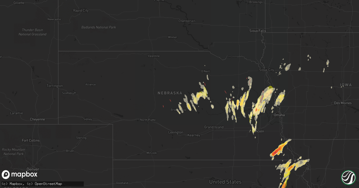
Hail Map in Nebraska on May 12, 2023
Get this storm
May 12 map
$229
one time, instant access
Download today. No call, no setup
Keep the $229
Bought the map and want the full workflow? Apply the entire $229 to a subscription within 7 days. None of it is wasted.
Every map, not just this one
This buys you this map. Subscription and you get every map we run, in the markets you choose from a few cities to whole states to nationwide. Plus real-time alerts the moment a storm fires.
Contact data
Name, contact info, occupancy, even credit band for addresses in the footprint. You go from where it hit to who to call.
Become the source they trust
Unlimited branding weather history reports on demand. You already have the documented answer ready for the property owner, and you are the one who showed up with it.
Property data and RoofTrace estimates
Pull up any address you have got, its value and the exact code rules for that jurisdiction, straight from One Click Code. Then RoofTrace estimates the squares, pitch, and roof value, priced the way you price.
Storm reports in Nebraska
Nebraska
| Date | Description |
|---|---|
| 05/12/20236:57 PM CDT | Damage to a farmstead. Possible tornado. |
| 05/12/20236:50 PM CDT | Report from mping: 3-inch tree limbs broken; power poles broken. Delayed report. |
| 05/12/20236:36 PM CDT | *** 2 inj *** large wedge tornado reported in western portions of the county. Delayed report of 2 known injuries between lyons and oakland. Widespread damage with numer |
| 05/12/20236:36 PM CDT | Tornadic debris signature still indicating a large tornado. |
| 05/12/20236:35 PM CDT | Power lines blown down. |
| 05/12/20236:32 PM CDT | A local report indicates 1.00 inch wind near AUBURN |
| 05/12/20236:30 PM CDT | Substantial damage to a farmstead. |
| 05/12/20236:28 PM CDT | Substantial farmstead damage. |
| 05/12/20236:23 PM CDT | Anticylonic tornado orbiting the main tornado cone. |
| 05/12/20236:23 PM CDT | Two farm outbuildings destroyed. Delayed report. |
| 05/12/20236:20 PM CDT | A local report indicates a tornado near 3 ESE CARROLL |
| 05/12/20236:19 PM CDT | Large... Violent tornado. |
| 05/12/20236:17 PM CDT | Very large violent tornado. |
| 05/12/20236:13 PM CDT | Personal weather station recorded a peak wind gust of 73 mph. |
| 05/12/20236:12 PM CDT | Report from mping: quarter |
| 05/12/20236:11 PM CDT | Damage to 3 car garage... Roof in trees. Diesel tank tipped over. |
| 05/12/20236:10 PM CDT | Commercial cattle feed lot heavily damaged... Several hundred cattle loose. |
| 05/12/20236:07 PM CDT | Power lines down... Lots of tree damage. |
| 05/12/20236:07 PM CDT | A local report indicates 1.75 inch wind near 3 E AUBURN |
| 05/12/20236:05 PM CDT | Tornadic debris signature continues. |
| 05/12/20236:03 PM CDT | Report from mping: homes/buildings completely destroyed. |
| 05/12/20236:01 PM CDT | Report from mping: 1-inch tree limbs broken; shingles blown off. |
| 05/12/20235:58 PM CDT | Personal weather station recorded a peak wind gust of 62 mph. |
| 05/12/20235:57 PM CDT | Multiple farmsteads damaged... Large power lines down... Trees shredded. Path approximately a half mile wide. |
| 05/12/20235:57 PM CDT | Multiple vortex tornado with rain wrapping curtains. |
| 05/12/20235:55 PM CDT | Unoccupied campers blown over. Many farm structures damaged and large trees snapped and broken. Powerlines and large trees blocking the road east of stanton. |
| 05/12/20235:50 PM CDT | A local report indicates a tornado near 2 WNW HOOPER |
| 05/12/20235:48 PM CDT | Corrects time of previous tornado report from 3 w hooper. Substantial damage to outbuildings on a farm. Delayed report. |
| 05/12/20235:46 PM CDT | Report from mping: trees uprooted or snapped; roof blown off. |
| 05/12/20235:45 PM CDT | A local report indicates a tornado near 4 WSW HOOPER |
| 05/12/20235:45 PM CDT | Report from mping: ping pong ball |
| 05/12/20235:44 PM CDT | Report from mping: half dollar |
| 05/12/20235:38 PM CDT | Tornado debris signature still on radar. |
| 05/12/20235:37 PM CDT | Report from mping: half dollar |
| 05/12/20235:36 PM CDT | Delayed report. |
| 05/12/20235:24 PM CDT | A local report indicates a tornado near 5 NW AMES |
| 05/12/20235:23 PM CDT | Farmstead damaged. Power lines also down in the area. |
| 05/12/20235:23 PM CDT | A local report indicates a tornado near 4 ENE NORTH BEND |
| 05/12/20235:23 PM CDT | Home damaged from tornado. |
| 05/12/20235:20 PM CDT | Picture from twitter. Delayed report. |
| 05/12/20235:20 PM CDT | A local report indicates a tornado near 1 ESE NORTH BEND |
| 05/12/20235:18 PM CDT | A local report indicates 2.75 inch wind near 7 E ELK CREEK |
| 05/12/20235:15 PM CDT | A local report indicates 2.00 inch wind near 4 WNW HUMBOLDT |
| 05/12/20235:12 PM CDT | Report from mping: baseball+ |
| 05/12/20235:10 PM CDT | A local report indicates a tornado near 1 ENE LEIGH |
| 05/12/20235:09 PM CDT | A local report indicates 2.75 inch wind near 3 E TABLE ROCK |
| 05/12/20235:03 PM CDT | East side of a barn missing. Possible tornado. Delayed report. Time estimated from radar. |
| 05/12/20235:02 PM CDT | Report from mping: trees uprooted or snapped; roof blown off. |
| 05/12/20234:59 PM CDT | Report from mping: 3-inch tree limbs broken; power poles broken. |
| 05/12/20234:55 PM CDT | A local report indicates 2.75 inch wind near TABLE ROCK |
| 05/12/20234:54 PM CDT | Report from mping: half dollar |
| 05/12/20234:53 PM CDT | Multiple photos on social media. |
| 05/12/20234:53 PM CDT | Delayed report. |
| 05/12/20234:52 PM CDT | A local report indicates a tornado near 2 S TABLE ROCK |
| 05/12/20234:48 PM CDT | 4 inch tree limbs blown down. |
| 05/12/20234:45 PM CDT | Personal weather station recorded a peak wind gust of 59 mph. |
| 05/12/20234:43 PM CDT | Tornado on the ground 8 miles south of chambers. |
| 05/12/20234:42 PM CDT | A local report indicates 1.75 inch wind near PLATTE CENTER |
| 05/12/20234:41 PM CDT | Rope tornado. |
| 05/12/20234:35 PM CDT | A local report indicates a tornado near 1 NE PAWNEE CITY |
| 05/12/20234:32 PM CDT | Public report of a tornado touchdown. |
| 05/12/20234:27 PM CDT | A local report indicates 1.00 inch wind near COLUMBUS |
| 05/12/20234:22 PM CDT | Delayed report. |
| 05/12/20234:21 PM CDT | Tornado damage... Small farm buildings damaged... Debris on roadway. |
| 05/12/20234:19 PM CDT | Damage path across highway 32. |
| 05/12/20234:13 PM CDT | A local report indicates a tornado near 1 E LINDSAY |
| 05/12/20234:00 PM CDT | Fire department reportedarope tornado approximately 6 miles north of arnold. |
| 05/12/20233:58 PM CDT | Personal weather station recorded a peak wind gust of 63 mph. |
| 05/12/20233:43 PM CDT | A local report indicates a tornado near 5 S LINDSAY |
| 05/12/20233:41 PM CDT | Report received via social media. |
| 05/12/20233:30 PM CDT | Report of flipped pivots in eastern nance county. |
| 05/12/20233:23 PM CDT | A local report indicates 1.25 inch wind near 2 NNE PLEASANT DALE |
| 05/12/20233:17 PM CDT | Quarter sized hail falling. |
| 05/12/20233:14 PM CDT | A local report indicates 1.00 inch wind near 2 ESE PLEASANT DALE |
| 05/12/20232:30 PM CDT | Report of flipped pivots in eastern nance county. |
| 05/12/20232:25 PM CDT | Numerous photos and videos of a tornado located west of spalding. Public report of leaning power poles and windows broken out of a pickup at the intersection of hwy 281 |
| 05/12/20232:23 PM CDT | Pea to quarter sized hail. |
| 05/12/202312:47 PM CDT | Brief tornado touchdown. |
| 05/12/202312:42 PM CDT | Custer county emergency manager reports a tornado on the ground. Has since lifted. |
| 05/11/20237:43 PM CDT | Brief spin-up... Lasted 15 seconds. |
| 05/11/20237:35 PM CDT | Report from mping: quarter |
| 05/11/20237:24 PM CDT | Corrects previous funnel cloud report from 4 wsw preston. Observed rope tornado approx 5 mi south falls city. Lasted 3-5 minutes. |
| 05/11/20237:22 PM CDT | A local report indicates 1.00 inch wind near 2 S WINSLOW |
All States Impacted by Hail Map on May 12, 2023
Cities Impacted by Hail Map on May 12, 2023
- Stapleton, NE
- Halsey, NE
- Arnold, NE
- Anselmo, NE
- Broken Bow, NE
- Comstock, NE
- Arcadia, NE
- Ansley, NE
- Blountstown, FL
- Bristol, FL
- Quincy, FL
- Hosford, FL
- Selmer, TN
- Alford, FL
- Marianna, FL
- Bascom, FL
- Greenwood, FL
- Ord, NE
- Elyria, NE
- Burwell, NE
- Ericson, NE
- Whigham, GA
- Climax, GA
- Odessa, TX
- Wewahitchka, FL
- Pleasant Dale, NE
- Denton, NE
- Lincoln, NE
- Malcolm, NE
- Stromsburg, NE
- Osceola, NE
- Fullerton, NE
- Genoa, NE
- Gardendale, TX
- Saint Edward, NE
- Garland, NE
- Rush Springs, OK
- Seymour, TX
- Monroe, NE
- Mount Olive, MS
- Prentiss, MS
- Newhebron, MS
- Valparaiso, NE
- Raymond, NE
- Aspermont, TX
- Bartlett, NE
- Chambers, NE
- Braxton, MS
- Lindsay, NE
- Dothan, AL
- Midland City, AL
- Platte Center, NE
- David City, NE
- Bellwood, NE
- Rising City, NE
- Columbus, NE
- Sterling City, TX
- Humphrey, NE
- Pawnee City, NE
- Steinauer, NE
- Ozona, TX
- Goree, TX
- Rotan, TX
- Table Rock, NE
- Humboldt, NE
- Leigh, NE
- Creston, NE
- Goldsmith, TX
- Auburn, NE
- Knott, TX
- Stanton, TX
- Big Spring, TX
- North Bend, NE
- Garden City, TX
- Johnson, NE
- Ames, NE
- Hooper, NE
- Scribner, NE
- Clarkson, NE
- Morse Bluff, NE
- Hamlin, TX
- Ninnekah, OK
- Verden, OK
- Chickasha, OK
- Dwight, NE
- Brainard, NE
- Prague, NE
- Okarche, OK
- Linwood, NE
- Howells, NE
- Red Rock, OK
- Marland, OK
- Ponca City, OK
- Big Lake, TX
- West Point, NE
- Inglis, FL
- Yankeetown, FL
- Crystal River, FL
- High Springs, FL
- Alachua, FL
- Brownville, NE
- Wellborn, FL
- Lake City, FL
- Oakland, NE
- Peru, NE
- Hamilton, KS
- Virgil, KS
- Wayne, NE
- Madison, KS
- Kingfisher, OK
- O'Brien, FL
- Branford, FL
- Fort White, FL
- Tonkawa, OK
- Blackwell, OK
- Lyons, NE
- Pilger, NE
- Stanton, NE
- Brock, NE
- Madison, NE
- Samson, AL
- Spalding, NE
- Greeley, NE
- Sallis, MS
- Carthage, MS
- Monticello, FL
- Forest, MS
- Chatham, MS
- Greenville, MS
- Glen Allan, MS
- Hollandale, MS
- West Point, MS
- Newton, AL
- Hartford, AL
- Colorado City, TX
- Westbrook, TX
- Hazlehurst, MS
- Rogers, NE
- Dodge, NE
- Kermit, TX
- Philadelphia, MS
- Munday, TX
- Marathon, TX
- Brandon, MS
- Cuthbert, GA
- Scotia, NE
- Thomasville, GA
- Boston, GA
- Elk Creek, NE
- Magee, MS
- Raleigh, MS
- Mendenhall, MS
- Ackerly, TX
- Lamesa, TX
- Bassfield, MS
- Loraine, TX
- Slocomb, AL
- Mize, MS
- Gail, TX
- Doerun, GA
- Albany, GA
- Albion, NE
- Newman Grove, NE
- Lena, MS
- Comstock, TX
- Wetmore, KS
- Holton, KS
- Netawaka, KS
- Silver Creek, NE
- Laurel, MS
- Bainbridge, GA
- Attapulgus, GA
- Lakeland, GA
- Pelham, GA
- Cairo, GA
- Brookhaven, MS
- Wesson, MS
- Columbia, MS
- Wolbach, NE
- Jayton, TX
- Snyder, TX
- Bruno, NE
- Abie, NE
- Flora, MS
- Meadville, MS
- Midland, TX
- Malmo, NE
- Meadow Grove, NE
- Russellville, AL
- Enterprise, AL
- New Brockton, AL
- Starkville, MS
- Pelahatchie, MS
- Morton, MS
- Abbeville, AL
- O'Brien, TX
- Fort Rucker, AL
- Martell, NE
- Crete, NE
- Chipley, FL
- Live Oak, FL
- Headland, AL
- Shorterville, AL
- Columbia, AL
- Newville, AL
- Noxapater, MS
- Cedarbluff, MS
- Terry, MS
- Newellton, LA
- Kosciusko, MS
- Homerville, GA
- Ashburn, GA
- Seminary, MS
- Colon, NE
- Weston, NE
- Cedar Bluffs, NE
- Crystal Springs, MS
- Gordon, AL
- Clayton, AL
- Kentwood, LA
- Burchard, NE
- Polk, NE
- Hordville, NE
- Clarks, NE
- Alpine, TX
- Mershon, GA
- Statenville, GA
- Jasper, FL
- Lake Park, GA
- Coffee Springs, AL
- Florence, MS
- Fort Stockton, TX
- Justiceburg, TX
- Pinola, MS
- Greenville, FL
- Norfolk, NE
- Donalsonville, GA
- Battle Creek, NE
- Sonora, TX
- Bee, NE
- Union, MS
- Bristol, GA
- Jack, AL
- Summit, MS
- Magnolia, MS
- Fairview, KS
- Ariton, AL
- Ozark, AL
- Mission, SD
- Bude, MS
- Imperial, TX
- Morris, GA
- Utica, MS
- Edison, GA
- Morgan, GA
- Brundidge, AL
- Troy, AL
- Collins, MS
- Youngstown, FL
- Panama City, FL
- Chattahoochee, FL
- Decatur, MS
- Post, TX
- Raymond, MS
- Taylor, NE
- Sargent, NE
- Milford, NE
- Yazoo City, MS
- Loup City, NE
- Bradley, OK
- Louisville, MS
- Mertzon, TX
- Kinston, AL
- Chancellor, AL
- Ty Ty, GA
- Sumner, GA
- Devol, OK
- Burkburnett, TX
- Georgetown, MS
- Harrisville, MS
- Fountain, FL
- Conehatta, MS
- Baileyville, KS
- Schuyler, NE
- Gridley, KS
- Knox City, TX
- Rochester, TX
- Haskell, TX
- Weinert, TX
- Merkel, TX
- Trent, TX
- Hiawatha, KS
- Del Rio, TX
- Laughlin Afb, TX
- Brackettville, TX
- Quemado, TX
- Uehling, NE
- Newkirk, OK
- Eagle Pass, TX
- Severy, KS
- Fall River, KS
- Throckmorton, TX
- Stamford, TX
- Hawley, TX
- Anson, TX
- Abilene, TX
- Newcastle, TX
- Whiting, KS
- Horton, KS
- Muscotah, KS
- Powhattan, KS
- Winslow, NE
- Topeka, KS
- Silver Lake, KS
- Delia, KS
- Hoyt, KS
- Mayetta, KS
- Cedar Vale, KS
- Omega, OK
- Fremont, NE
- Lueders, TX
- Avoca, TX
- Albany, TX
- Holliday, TX
- Olney, TX
- Carrizo Springs, TX
- Denison, KS
- Eureka, KS
- Millry, AL
- Uvalde, TX
- Camp Wood, TX
- Barksdale, TX
- Baird, TX
- Moran, TX
- Cisco, TX
- Rocksprings, TX
- Leakey, TX
- Rio Frio, TX
- Wingate, TX
- Winters, TX
- Junction, TX
- Oregon, MO
- Pisgah, IA
- Mondamin, IA
- Asherton, TX
- Craig, NE
- Tekamah, NE
- Decatur, NE
- Onawa, IA
- Logan, IA
- Menard, TX
- Melvin, TX
- Lohn, TX
- Eden, TX
- Vancourt, TX
- Paint Rock, TX
- Millersview, TX
- Doole, TX
- Rochelle, TX
- Gouldbusk, TX
- Santa Anna, TX
- Rockwood, TX
- Batesville, TX
- Sabinal, TX
- Brookesmith, TX
- D Hanis, TX
- Tilden, NE
- Woodbine, IA
- Crescent, OK
- Watonga, OK
- Oneill, NE
- Goff, KS
- Maramec, OK
- Pawnee, OK
- Iowa Park, TX
- Bronte, TX
- Blackwell, TX
- Roby, TX
- Sweetwater, TX
- Roscoe, TX
- Lauderdale, MS
- Toomsuba, MS
- Cuba, AL
- Harveyville, KS
- Eldorado, TX
- Sylvester, TX
- McCaulley, TX
- Burlington, KS
- Chunky, MS
- Hickory, MS
- Pulaski, MS
- Piedmont, KS
- Howard, KS
- Monroeville, AL
- Preston, MS
- Blencoe, IA
- Repton, AL
- Lenox, AL
- Frisco City, AL
- Range, AL
- Modale, IA
- Missouri Valley, IA
- Blair, NE
- Magnolia, IA
- Dexter, KS
- Burden, KS
- Kennard, NE
- Stringer, MS
- Christoval, TX
- Lake, MS
- Atmore, AL
- Meridian, MS
- Lisman, AL
- Shidler, OK
- Sweet Water, AL
- Rock Port, MO
- Watson, MO
- Crane, TX
- Little Rock, MS
- Collinsville, MS
- Fairfax, OK
- Burbank, OK
- Midkiff, TX
- Toronto, KS
- Robinson, KS
- Bay Springs, MS
- Iraan, TX
- Hamburg, IA
- Stella, NE
- Buffalo Gap, TX
- Woodson, TX
- Graham, TX
- Silas, AL
- Buckatunna, MS
- Rule, TX
- Baker, FL
- Peterman, AL
- San Angelo, TX
- Opp, AL
- Bennington, NE
- Malone, FL
- Herman, NE
- Waynesboro, MS
- Marion, MS
- Leakesville, MS
- Neely, MS
- Castleberry, AL
- Atlanta, KS
- Cambridge, KS
- Latham, KS
- Bailey, MS
- Gilbertown, AL
- Shubuta, MS
- Evergreen, AL
- Highland, KS
- Falls City, NE
- Morrill, KS
- White Cloud, KS
- Forest City, MO
- Tuscola, TX
- Wisner, NE
- Wakefield, NE
- Dunnellon, FL
- Carlsbad, TX
- Fredonia, KS
- Bronson, FL
- Chiefland, FL
- Palmetto, FL
- Ellenton, FL
- Hennessey, OK
- Cashion, OK
- Montgomery, AL
- Hope Hull, AL
- Robert Lee, TX
- Windthorst, TX
- Old Glory, TX
- Paducah, TX
- Vredenburgh, AL
- Franklin, AL
- Norton, TX
- Mulhall, OK
- Thomasville, AL
- Heidelberg, MS
- Washington, NE
- Seneca, KS
- Guthrie, OK
- Dover, OK
- Porterville, MS
- Clayton, LA
- Whatley, AL
- Newton, MS
- Byram, MS
- McCall Creek, MS
- Nickerson, NE
- Arlington, NE
- Rossville, KS
- Coleman, GA
- Yates Center, KS
- Sabetha, KS
- Chatom, AL
- Deer Park, AL
- Archer City, TX
- Electra, TX
- Eskridge, KS
- Emelle, AL
- Denton, KS
- Fillmore, MO
- Amazonia, MO
- Savannah, MO
- Everest, KS
- Circleville, KS
- Oneida, KS
- Troy, KS
- Morriston, FL
- Smithdale, MS
- Longton, KS
- Jourdanton, TX
- Poteet, TX
- Pleasanton, TX
- Charlotte, TX
- San Antonio, TX
- Von Ormy, TX
- Elmendorf, TX
- Somerset, TX
- McCune, KS
- Columbus, KS
- Holstein, IA
- Cushing, IA
- Washta, IA
- May, TX
- Early, TX
- Fischer, TX
- Wimberley, TX
- Pawhuska, OK
- Clinton, OK
- Devine, TX
- Havelock, IA
- Henrietta, TX
- Quimby, IA
- Correctionville, IA
- Cherokee, IA
- Oswego, KS
- Calumet, OK
- Geary, OK
- Wathena, KS
- Foss, OK
- Canute, OK
- Natalia, TX
- Dawson, NE
- Verdon, NE
- Crystal City, TX
- Laurens, IA
- Bluff Dale, TX
- Ralston, OK
- Galena, KS
- Parsons, KS
- Galesburg, KS
- Dennis, KS
- El Reno, OK
- Thomas, OK
- Coyle, OK
- Loving, TX
- Erie, KS
- Coleman, TX
- La Pryor, TX
- Robinsonville, MS
- Tunica, MS
- Marcus, IA
- Cleghorn, IA
- Anthon, IA
- Glencoe, OK
- Morrison, OK
- Cherryvale, KS
- Benedict, KS
- Neodesha, KS
- Elk City, KS
- Independence, KS
- Altoona, KS
- San Saba, TX
- Lampasas, TX
- Billings, OK
- Stillwater, OK
- Center Point, TX
- Moorhead, IA
- Cherokee, TX
- Dunlap, IA
- Pocasset, OK
- Cross Plains, TX
- Greenfield, OK
- Blanket, TX
- Comanche, TX
- Thayer, MO
- Couch, MO
- Mammoth Spring, AR
- Weatherford, OK
- Konawa, OK
- Rising Star, TX
- Altamont, KS
- Mound Valley, KS
- Ravenden Springs, AR
- Ravenden, AR
- Dill City, OK
- Elk City, OK
- Zephyr, TX
- Stratford, OK
- San Ygnacio, TX
- Mound City, MO
- Brownwood, TX
- Chetopa, KS
- Mason, TX
- Doss, TX
- Storm Lake, IA
- Schaller, IA
- Early, IA
- Soldier, IA
- Fort Calhoun, NE
- Perkins, OK
- Moville, IA
- Willow City, TX
- Fredericksburg, TX
- Stephenville, TX
- Helotes, TX
- Pierson, IA
- Kingsley, IA
- Goldthwaite, TX
- Nebraska City, NE
- Baxter Springs, KS
- Riverton, KS
- Medina, TX
- Perry, OK
- Orlando, OK
- Bluffton, TX
- Yancey, TX
- Pearsall, TX
- Wayne, OK
- Purcell, OK
- Zapata, TX
- Corning, KS
- Rosendale, MO
- Jacksboro, TX
- Craig, MO
- La Harpe, KS
- Humboldt, KS
- Stark, KS
- Savonburg, KS
- Fort Dodge, IA
- Asbury, MO
- Albert City, IA
- Steele, MO
- Mission, TX
- San Perlita, TX
- Driftwood, TX
- Joplin, MO
- Flatonia, TX
- Waelder, TX
- Eufaula, OK
- Thayer, KS
- Hidalgo, TX
- Pharr, TX
- Mcallen, TX
- Hayti, MO
- Bragg City, MO
- Bartlett, KS
- Moorland, IA
- Williamsville, MO
- Weir, KS
- Cherokee, KS
- Scammon, KS
- Cibolo, TX
- Schertz, TX
- Moore, TX
- Hondo, TX
- Gobler, MO
- Hornersville, MO
- Dustin, OK
- Badger, IA
- Humboldt, IA
- Poplar Bluff, MO
- Minco, OK
- Kinta, OK
- Mcalester, OK
- Lamar, OK
- Harlingen, TX
- Rio Hondo, TX
- Doniphan, MO
- Cement, OK
- Hindsville, AR
- Rogers, AR
- Alamo, TX
- Chester, AR
- Converse, TX
- Tynan, TX
- Mathis, TX
- Greenway, AR
- Dyersburg, TN
- Carl Junction, MO
- Pauls Valley, OK
- Sasakwa, OK
- Maxwell, TX
- Kyle, TX
- New Braunfels, TX
- Mccurtain, OK
- Muldrow, OK
- Uniontown, AR
- Paoli, OK
- Carthage, MO
- Red Oak, OK
- Port Isabel, TX
- Los Fresnos, TX
- Elkins, AR
- Ogden, IA
- Hanna, OK
- Rogers, TX
- Falls City, TX
- Ames, IA


