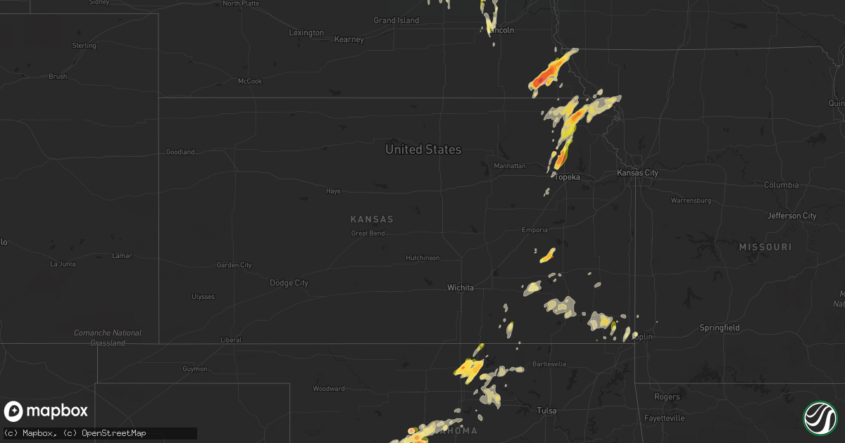
Hail Map in Kansas on May 12, 2023
Get this storm
May 12 map
$229
one time, instant access
Download today. No call, no setup
Keep the $229
Bought the map and want the full workflow? Apply the entire $229 to a subscription within 7 days. None of it is wasted.
Every map, not just this one
This buys you this map. Subscription and you get every map we run, in the markets you choose from a few cities to whole states to nationwide. Plus real-time alerts the moment a storm fires.
Contact data
Name, contact info, occupancy, even credit band for addresses in the footprint. You go from where it hit to who to call.
Become the source they trust
Unlimited branding weather history reports on demand. You already have the documented answer ready for the property owner, and you are the one who showed up with it.
Property data and RoofTrace estimates
Pull up any address you have got, its value and the exact code rules for that jurisdiction, straight from One Click Code. Then RoofTrace estimates the squares, pitch, and roof value, priced the way you price.
Storm reports in Kansas
Kansas
| Date | Description |
|---|---|
| 05/12/20236:33 PM CDT | Em relayed quarter sized to hail to a few golf ball sized. |
| 05/12/20236:16 PM CDT | Report from mping: quarter |
| 05/12/202312:44 AM CDT | Delayed report of a tree uprooted in the 1400 block of morton avenue. Time was estimated via radar. |
| 05/11/20237:43 PM CDT | A local report indicates 1.00 inch wind near 1 S CLIMAX |
| 05/11/20237:42 PM CDT | A local report indicates 1.00 inch wind near CLIMAX |
| 05/11/20237:37 PM CDT | Tornado on the ground west of whiting. |
| 05/11/20237:36 PM CDT | Pictured on social media. |
| 05/11/20237:33 PM CDT | A local report indicates 1.00 inch wind near 1 S MAYETTA |
| 05/11/20237:16 PM CDT | Several large tree limbs 6 to 8 inches in diameter broken off trees. |
| 05/11/20237:06 PM CDT | Spotter reports tornado on the ground northeast of sabetha. |
| 05/11/20237:06 PM CDT | Measured 2.2 inch hail 1 mile north of hwy 73 and 170th st. |
| 05/11/20237:04 PM CDT | A local report indicates 1.50 inch wind near 3 WSW WILLIS |
| 05/11/20237:02 PM CDT | A local report indicates 1.00 inch wind near 3 WSW WILLIS |
All States Impacted by Hail Map on May 12, 2023
Cities Impacted by Hail Map on May 12, 2023
- Stapleton, NE
- Halsey, NE
- Arnold, NE
- Anselmo, NE
- Broken Bow, NE
- Comstock, NE
- Arcadia, NE
- Ansley, NE
- Blountstown, FL
- Bristol, FL
- Quincy, FL
- Hosford, FL
- Selmer, TN
- Alford, FL
- Marianna, FL
- Bascom, FL
- Greenwood, FL
- Ord, NE
- Elyria, NE
- Burwell, NE
- Ericson, NE
- Whigham, GA
- Climax, GA
- Odessa, TX
- Wewahitchka, FL
- Pleasant Dale, NE
- Denton, NE
- Lincoln, NE
- Malcolm, NE
- Stromsburg, NE
- Osceola, NE
- Fullerton, NE
- Genoa, NE
- Gardendale, TX
- Saint Edward, NE
- Garland, NE
- Rush Springs, OK
- Seymour, TX
- Monroe, NE
- Mount Olive, MS
- Prentiss, MS
- Newhebron, MS
- Valparaiso, NE
- Raymond, NE
- Aspermont, TX
- Bartlett, NE
- Chambers, NE
- Braxton, MS
- Lindsay, NE
- Dothan, AL
- Midland City, AL
- Platte Center, NE
- David City, NE
- Bellwood, NE
- Rising City, NE
- Columbus, NE
- Sterling City, TX
- Humphrey, NE
- Pawnee City, NE
- Steinauer, NE
- Ozona, TX
- Goree, TX
- Rotan, TX
- Table Rock, NE
- Humboldt, NE
- Leigh, NE
- Creston, NE
- Goldsmith, TX
- Auburn, NE
- Knott, TX
- Stanton, TX
- Big Spring, TX
- North Bend, NE
- Garden City, TX
- Johnson, NE
- Ames, NE
- Hooper, NE
- Scribner, NE
- Clarkson, NE
- Morse Bluff, NE
- Hamlin, TX
- Ninnekah, OK
- Verden, OK
- Chickasha, OK
- Dwight, NE
- Brainard, NE
- Prague, NE
- Okarche, OK
- Linwood, NE
- Howells, NE
- Red Rock, OK
- Marland, OK
- Ponca City, OK
- Big Lake, TX
- West Point, NE
- Inglis, FL
- Yankeetown, FL
- Crystal River, FL
- High Springs, FL
- Alachua, FL
- Brownville, NE
- Wellborn, FL
- Lake City, FL
- Oakland, NE
- Peru, NE
- Hamilton, KS
- Virgil, KS
- Wayne, NE
- Madison, KS
- Kingfisher, OK
- O'Brien, FL
- Branford, FL
- Fort White, FL
- Tonkawa, OK
- Blackwell, OK
- Lyons, NE
- Pilger, NE
- Stanton, NE
- Brock, NE
- Madison, NE
- Samson, AL
- Spalding, NE
- Greeley, NE
- Sallis, MS
- Carthage, MS
- Monticello, FL
- Forest, MS
- Chatham, MS
- Greenville, MS
- Glen Allan, MS
- Hollandale, MS
- West Point, MS
- Newton, AL
- Hartford, AL
- Colorado City, TX
- Westbrook, TX
- Hazlehurst, MS
- Rogers, NE
- Dodge, NE
- Kermit, TX
- Philadelphia, MS
- Munday, TX
- Marathon, TX
- Brandon, MS
- Cuthbert, GA
- Scotia, NE
- Thomasville, GA
- Boston, GA
- Elk Creek, NE
- Magee, MS
- Raleigh, MS
- Mendenhall, MS
- Ackerly, TX
- Lamesa, TX
- Bassfield, MS
- Loraine, TX
- Slocomb, AL
- Mize, MS
- Gail, TX
- Doerun, GA
- Albany, GA
- Albion, NE
- Newman Grove, NE
- Lena, MS
- Comstock, TX
- Wetmore, KS
- Holton, KS
- Netawaka, KS
- Silver Creek, NE
- Laurel, MS
- Bainbridge, GA
- Attapulgus, GA
- Lakeland, GA
- Pelham, GA
- Cairo, GA
- Brookhaven, MS
- Wesson, MS
- Columbia, MS
- Wolbach, NE
- Jayton, TX
- Snyder, TX
- Bruno, NE
- Abie, NE
- Flora, MS
- Meadville, MS
- Midland, TX
- Malmo, NE
- Meadow Grove, NE
- Russellville, AL
- Enterprise, AL
- New Brockton, AL
- Starkville, MS
- Pelahatchie, MS
- Morton, MS
- Abbeville, AL
- O'Brien, TX
- Fort Rucker, AL
- Martell, NE
- Crete, NE
- Chipley, FL
- Live Oak, FL
- Headland, AL
- Shorterville, AL
- Columbia, AL
- Newville, AL
- Noxapater, MS
- Cedarbluff, MS
- Terry, MS
- Newellton, LA
- Kosciusko, MS
- Homerville, GA
- Ashburn, GA
- Seminary, MS
- Colon, NE
- Weston, NE
- Cedar Bluffs, NE
- Crystal Springs, MS
- Gordon, AL
- Clayton, AL
- Kentwood, LA
- Burchard, NE
- Polk, NE
- Hordville, NE
- Clarks, NE
- Alpine, TX
- Mershon, GA
- Statenville, GA
- Jasper, FL
- Lake Park, GA
- Coffee Springs, AL
- Florence, MS
- Fort Stockton, TX
- Justiceburg, TX
- Pinola, MS
- Greenville, FL
- Norfolk, NE
- Donalsonville, GA
- Battle Creek, NE
- Sonora, TX
- Bee, NE
- Union, MS
- Bristol, GA
- Jack, AL
- Summit, MS
- Magnolia, MS
- Fairview, KS
- Ariton, AL
- Ozark, AL
- Mission, SD
- Bude, MS
- Imperial, TX
- Morris, GA
- Utica, MS
- Edison, GA
- Morgan, GA
- Brundidge, AL
- Troy, AL
- Collins, MS
- Youngstown, FL
- Panama City, FL
- Chattahoochee, FL
- Decatur, MS
- Post, TX
- Raymond, MS
- Taylor, NE
- Sargent, NE
- Milford, NE
- Yazoo City, MS
- Loup City, NE
- Bradley, OK
- Louisville, MS
- Mertzon, TX
- Kinston, AL
- Chancellor, AL
- Ty Ty, GA
- Sumner, GA
- Devol, OK
- Burkburnett, TX
- Georgetown, MS
- Harrisville, MS
- Fountain, FL
- Conehatta, MS
- Baileyville, KS
- Schuyler, NE
- Gridley, KS
- Knox City, TX
- Rochester, TX
- Haskell, TX
- Weinert, TX
- Merkel, TX
- Trent, TX
- Hiawatha, KS
- Del Rio, TX
- Laughlin Afb, TX
- Brackettville, TX
- Quemado, TX
- Uehling, NE
- Newkirk, OK
- Eagle Pass, TX
- Severy, KS
- Fall River, KS
- Throckmorton, TX
- Stamford, TX
- Hawley, TX
- Anson, TX
- Abilene, TX
- Newcastle, TX
- Whiting, KS
- Horton, KS
- Muscotah, KS
- Powhattan, KS
- Winslow, NE
- Topeka, KS
- Silver Lake, KS
- Delia, KS
- Hoyt, KS
- Mayetta, KS
- Cedar Vale, KS
- Omega, OK
- Fremont, NE
- Lueders, TX
- Avoca, TX
- Albany, TX
- Holliday, TX
- Olney, TX
- Carrizo Springs, TX
- Denison, KS
- Eureka, KS
- Millry, AL
- Uvalde, TX
- Camp Wood, TX
- Barksdale, TX
- Baird, TX
- Moran, TX
- Cisco, TX
- Rocksprings, TX
- Leakey, TX
- Rio Frio, TX
- Wingate, TX
- Winters, TX
- Junction, TX
- Oregon, MO
- Pisgah, IA
- Mondamin, IA
- Asherton, TX
- Craig, NE
- Tekamah, NE
- Decatur, NE
- Onawa, IA
- Logan, IA
- Menard, TX
- Melvin, TX
- Lohn, TX
- Eden, TX
- Vancourt, TX
- Paint Rock, TX
- Millersview, TX
- Doole, TX
- Rochelle, TX
- Gouldbusk, TX
- Santa Anna, TX
- Rockwood, TX
- Batesville, TX
- Sabinal, TX
- Brookesmith, TX
- D Hanis, TX
- Tilden, NE
- Woodbine, IA
- Crescent, OK
- Watonga, OK
- Oneill, NE
- Goff, KS
- Maramec, OK
- Pawnee, OK
- Iowa Park, TX
- Bronte, TX
- Blackwell, TX
- Roby, TX
- Sweetwater, TX
- Roscoe, TX
- Lauderdale, MS
- Toomsuba, MS
- Cuba, AL
- Harveyville, KS
- Eldorado, TX
- Sylvester, TX
- McCaulley, TX
- Burlington, KS
- Chunky, MS
- Hickory, MS
- Pulaski, MS
- Piedmont, KS
- Howard, KS
- Monroeville, AL
- Preston, MS
- Blencoe, IA
- Repton, AL
- Lenox, AL
- Frisco City, AL
- Range, AL
- Modale, IA
- Missouri Valley, IA
- Blair, NE
- Magnolia, IA
- Dexter, KS
- Burden, KS
- Kennard, NE
- Stringer, MS
- Christoval, TX
- Lake, MS
- Atmore, AL
- Meridian, MS
- Lisman, AL
- Shidler, OK
- Sweet Water, AL
- Rock Port, MO
- Watson, MO
- Crane, TX
- Little Rock, MS
- Collinsville, MS
- Fairfax, OK
- Burbank, OK
- Midkiff, TX
- Toronto, KS
- Robinson, KS
- Bay Springs, MS
- Iraan, TX
- Hamburg, IA
- Stella, NE
- Buffalo Gap, TX
- Woodson, TX
- Graham, TX
- Silas, AL
- Buckatunna, MS
- Rule, TX
- Baker, FL
- Peterman, AL
- San Angelo, TX
- Opp, AL
- Bennington, NE
- Malone, FL
- Herman, NE
- Waynesboro, MS
- Marion, MS
- Leakesville, MS
- Neely, MS
- Castleberry, AL
- Atlanta, KS
- Cambridge, KS
- Latham, KS
- Bailey, MS
- Gilbertown, AL
- Shubuta, MS
- Evergreen, AL
- Highland, KS
- Falls City, NE
- Morrill, KS
- White Cloud, KS
- Forest City, MO
- Tuscola, TX
- Wisner, NE
- Wakefield, NE
- Dunnellon, FL
- Carlsbad, TX
- Fredonia, KS
- Bronson, FL
- Chiefland, FL
- Palmetto, FL
- Ellenton, FL
- Hennessey, OK
- Cashion, OK
- Montgomery, AL
- Hope Hull, AL
- Robert Lee, TX
- Windthorst, TX
- Old Glory, TX
- Paducah, TX
- Vredenburgh, AL
- Franklin, AL
- Norton, TX
- Mulhall, OK
- Thomasville, AL
- Heidelberg, MS
- Washington, NE
- Seneca, KS
- Guthrie, OK
- Dover, OK
- Porterville, MS
- Clayton, LA
- Whatley, AL
- Newton, MS
- Byram, MS
- McCall Creek, MS
- Nickerson, NE
- Arlington, NE
- Rossville, KS
- Coleman, GA
- Yates Center, KS
- Sabetha, KS
- Chatom, AL
- Deer Park, AL
- Archer City, TX
- Electra, TX
- Eskridge, KS
- Emelle, AL
- Denton, KS
- Fillmore, MO
- Amazonia, MO
- Savannah, MO
- Everest, KS
- Circleville, KS
- Oneida, KS
- Troy, KS
- Morriston, FL
- Smithdale, MS
- Longton, KS
- Jourdanton, TX
- Poteet, TX
- Pleasanton, TX
- Charlotte, TX
- San Antonio, TX
- Von Ormy, TX
- Elmendorf, TX
- Somerset, TX
- McCune, KS
- Columbus, KS
- Holstein, IA
- Cushing, IA
- Washta, IA
- May, TX
- Early, TX
- Fischer, TX
- Wimberley, TX
- Pawhuska, OK
- Clinton, OK
- Devine, TX
- Havelock, IA
- Henrietta, TX
- Quimby, IA
- Correctionville, IA
- Cherokee, IA
- Oswego, KS
- Calumet, OK
- Geary, OK
- Wathena, KS
- Foss, OK
- Canute, OK
- Natalia, TX
- Dawson, NE
- Verdon, NE
- Crystal City, TX
- Laurens, IA
- Bluff Dale, TX
- Ralston, OK
- Galena, KS
- Parsons, KS
- Galesburg, KS
- Dennis, KS
- El Reno, OK
- Thomas, OK
- Coyle, OK
- Loving, TX
- Erie, KS
- Coleman, TX
- La Pryor, TX
- Robinsonville, MS
- Tunica, MS
- Marcus, IA
- Cleghorn, IA
- Anthon, IA
- Glencoe, OK
- Morrison, OK
- Cherryvale, KS
- Benedict, KS
- Neodesha, KS
- Elk City, KS
- Independence, KS
- Altoona, KS
- San Saba, TX
- Lampasas, TX
- Billings, OK
- Stillwater, OK
- Center Point, TX
- Moorhead, IA
- Cherokee, TX
- Dunlap, IA
- Pocasset, OK
- Cross Plains, TX
- Greenfield, OK
- Blanket, TX
- Comanche, TX
- Thayer, MO
- Couch, MO
- Mammoth Spring, AR
- Weatherford, OK
- Konawa, OK
- Rising Star, TX
- Altamont, KS
- Mound Valley, KS
- Ravenden Springs, AR
- Ravenden, AR
- Dill City, OK
- Elk City, OK
- Zephyr, TX
- Stratford, OK
- San Ygnacio, TX
- Mound City, MO
- Brownwood, TX
- Chetopa, KS
- Mason, TX
- Doss, TX
- Storm Lake, IA
- Schaller, IA
- Early, IA
- Soldier, IA
- Fort Calhoun, NE
- Perkins, OK
- Moville, IA
- Willow City, TX
- Fredericksburg, TX
- Stephenville, TX
- Helotes, TX
- Pierson, IA
- Kingsley, IA
- Goldthwaite, TX
- Nebraska City, NE
- Baxter Springs, KS
- Riverton, KS
- Medina, TX
- Perry, OK
- Orlando, OK
- Bluffton, TX
- Yancey, TX
- Pearsall, TX
- Wayne, OK
- Purcell, OK
- Zapata, TX
- Corning, KS
- Rosendale, MO
- Jacksboro, TX
- Craig, MO
- La Harpe, KS
- Humboldt, KS
- Stark, KS
- Savonburg, KS
- Fort Dodge, IA
- Asbury, MO
- Albert City, IA
- Steele, MO
- Mission, TX
- San Perlita, TX
- Driftwood, TX
- Joplin, MO
- Flatonia, TX
- Waelder, TX
- Eufaula, OK
- Thayer, KS
- Hidalgo, TX
- Pharr, TX
- Mcallen, TX
- Hayti, MO
- Bragg City, MO
- Bartlett, KS
- Moorland, IA
- Williamsville, MO
- Weir, KS
- Cherokee, KS
- Scammon, KS
- Cibolo, TX
- Schertz, TX
- Moore, TX
- Hondo, TX
- Gobler, MO
- Hornersville, MO
- Dustin, OK
- Badger, IA
- Humboldt, IA
- Poplar Bluff, MO
- Minco, OK
- Kinta, OK
- Mcalester, OK
- Lamar, OK
- Harlingen, TX
- Rio Hondo, TX
- Doniphan, MO
- Cement, OK
- Hindsville, AR
- Rogers, AR
- Alamo, TX
- Chester, AR
- Converse, TX
- Tynan, TX
- Mathis, TX
- Greenway, AR
- Dyersburg, TN
- Carl Junction, MO
- Pauls Valley, OK
- Sasakwa, OK
- Maxwell, TX
- Kyle, TX
- New Braunfels, TX
- Mccurtain, OK
- Muldrow, OK
- Uniontown, AR
- Paoli, OK
- Carthage, MO
- Red Oak, OK
- Port Isabel, TX
- Los Fresnos, TX
- Elkins, AR
- Ogden, IA
- Hanna, OK
- Rogers, TX
- Falls City, TX
- Ames, IA


