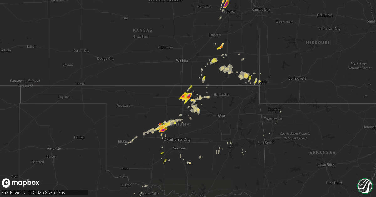
Hail Map on May 12, 2023
Get this storm
May 12 map
$229
one time, instant access
Download today. No call, no setup
Keep the $229
Bought the map and want the full workflow? Apply the entire $229 to a subscription within 7 days. None of it is wasted.
Every map, not just this one
This buys you this map. Subscription and you get every map we run, in the markets you choose from a few cities to whole states to nationwide. Plus real-time alerts the moment a storm fires.
Contact data
Name, contact info, occupancy, even credit band for addresses in the footprint. You go from where it hit to who to call.
Become the source they trust
Unlimited branding weather history reports on demand. You already have the documented answer ready for the property owner, and you are the one who showed up with it.
Property data and RoofTrace estimates
Pull up any address you have got, its value and the exact code rules for that jurisdiction, straight from One Click Code. Then RoofTrace estimates the squares, pitch, and roof value, priced the way you price.
States Impacted by Hail Map on May 12, 2023
Storm reports
Virginia
| Date | Description |
|---|---|
| 05/12/20233:18 PM CDT | One tree down due to thunderstorm winds along the 300 block of north main street. |
Iowa
| Date | Description |
|---|---|
| 05/12/20236:44 PM CDT | Report from mping: 1-inch tree limbs broken; shingles blown off. |
| 05/11/20238:34 PM CDT | Numerous 1 to 2 inch tree branches down... With one up to 4 inches in diameter. Winds estimated around 60 mph. |
| 05/11/20237:46 PM CDT | A local report indicates 60 MPH wind near SLOAN |
Florida
| Date | Description |
|---|---|
| 05/12/20236:57 PM CDT | Tree fell onto house along nw ridgewood ave. Time of event estimated via radar. |
| 05/12/20236:30 PM CDT | Alachua county 911/dispatch reports that a tree was downed over a powerline by strong wind gusts along nw 154th place in the vicinity of high springs. Time of damage ba |
| 05/12/20236:10 PM CDT | Sheriffs 911 dispatch reported downed trees laid across u.s. 90 west of wellborn. |
| 05/12/20232:45 PM CDT | Estimated size from photo on social media. |
| 05/12/20232:30 PM CDT | Multiple downed trees at the intersection of mineral rd and woodberry rd. |
| 05/12/20232:00 PM CDT | Estimated quarter sized hail from social media report in alford. |
| 05/12/20231:55 PM CDT | Estimated quarter sized hail from social media report near compass lake. |
| 05/12/202312:20 PM CDT | Estimated quarter sized hail from social media report south of blountstown. |
| 05/11/20237:28 PM CDT | Tree down near w old wire rd and sw cook st. Time of event estimated via radar. |
| 05/11/20237:11 PM CDT | Tree down near sw cavalry pl and sw bloomington terrace. Time of event estimated via radar. |
Kansas
| Date | Description |
|---|---|
| 05/12/20236:33 PM CDT | Em relayed quarter sized to hail to a few golf ball sized. |
| 05/12/20236:16 PM CDT | Report from mping: quarter |
| 05/12/202312:44 AM CDT | Delayed report of a tree uprooted in the 1400 block of morton avenue. Time was estimated via radar. |
| 05/11/20237:43 PM CDT | A local report indicates 1.00 inch wind near 1 S CLIMAX |
| 05/11/20237:42 PM CDT | A local report indicates 1.00 inch wind near CLIMAX |
| 05/11/20237:37 PM CDT | Tornado on the ground west of whiting. |
| 05/11/20237:36 PM CDT | Pictured on social media. |
| 05/11/20237:33 PM CDT | A local report indicates 1.00 inch wind near 1 S MAYETTA |
| 05/11/20237:16 PM CDT | Several large tree limbs 6 to 8 inches in diameter broken off trees. |
| 05/11/20237:06 PM CDT | Measured 2.2 inch hail 1 mile north of hwy 73 and 170th st. |
| 05/11/20237:06 PM CDT | Spotter reports tornado on the ground northeast of sabetha. |
| 05/11/20237:04 PM CDT | A local report indicates 1.50 inch wind near 3 WSW WILLIS |
| 05/11/20237:02 PM CDT | A local report indicates 1.00 inch wind near 3 WSW WILLIS |
Missouri
| Date | Description |
|---|---|
| 05/12/20232:32 AM CDT | A local report indicates 1.00 inch wind near JOPLIN |
South Dakota
| Date | Description |
|---|---|
| 05/11/20237:48 PM CDT | A local report indicates 60 MPH wind near NORTH SIOUX CITY |
Alabama
| Date | Description |
|---|---|
| 05/12/20235:04 PM CDT | Trees reported down along county rd. 4 and new henson rd. Near slocomb... Al. |
| 05/12/20234:57 PM CDT | Tree reported down along ballard rd. |
| 05/12/20234:49 PM CDT | Trees reported down along hwy 87 north of samson... Al. |
| 05/12/20234:15 PM CDT | Corrected time. A few trees were reported down along county rd. 36 about 1.5mi. From 65. |
| 05/12/20233:51 PM CDT | Corrects previous tstm wnd gst report from 1 ene napier field. |
| 05/12/20233:30 PM CDT | Corrected time. Trees reported down along hwy 87 north of samson... Al. |
| 05/12/20232:51 PM CDT | A few trees were reported down along county rd. 36 about 1.5mi. From 65. |
Mississippi
| Date | Description |
|---|---|
| 05/12/20235:42 PM CDT | Tree down on causeyville road. |
| 05/12/20234:45 PM CDT | Delayed report. This corrects the time and location of the previous report of a tree downed on dentville rd. |
| 05/12/20234:45 PM CDT | Tree down on suttle road. |
| 05/12/20234:35 PM CDT | Tree on a house on highway 21n and trees down along the road. |
| 05/12/20234:35 PM CDT | Tree down on neshoba county road 729. |
| 05/12/20234:30 PM CDT | Tree down on neshoba county road 759. |
| 05/12/20234:28 PM CDT | Tree down on dentville road. |
| 05/12/20234:24 PM CDT | Tree down on neshoba county road 4300. |
| 05/12/20234:00 PM CDT | Tree down on neshoba county road 353. |
| 05/12/20233:35 PM CDT | Delayed report. Scattered trees downed around the county. |
Nebraska
| Date | Description |
|---|---|
| 05/12/20236:57 PM CDT | Damage to a farmstead. Possible tornado. |
| 05/12/20236:50 PM CDT | Report from mping: 3-inch tree limbs broken; power poles broken. Delayed report. |
| 05/12/20236:36 PM CDT | Tornadic debris signature still indicating a large tornado. |
| 05/12/20236:36 PM CDT | *** 2 inj *** large wedge tornado reported in western portions of the county. Delayed report of 2 known injuries between lyons and oakland. Widespread damage with numer |
| 05/12/20236:35 PM CDT | Power lines blown down. |
| 05/12/20236:32 PM CDT | A local report indicates 1.00 inch wind near AUBURN |
| 05/12/20236:30 PM CDT | Substantial damage to a farmstead. |
| 05/12/20236:28 PM CDT | Substantial farmstead damage. |
| 05/12/20236:23 PM CDT | Two farm outbuildings destroyed. Delayed report. |
| 05/12/20236:23 PM CDT | Anticylonic tornado orbiting the main tornado cone. |
| 05/12/20236:20 PM CDT | A local report indicates a tornado near 3 ESE CARROLL |
| 05/12/20236:19 PM CDT | Large... Violent tornado. |
| 05/12/20236:17 PM CDT | Very large violent tornado. |
| 05/12/20236:13 PM CDT | Personal weather station recorded a peak wind gust of 73 mph. |
| 05/12/20236:12 PM CDT | Report from mping: quarter |
| 05/12/20236:11 PM CDT | Damage to 3 car garage... Roof in trees. Diesel tank tipped over. |
| 05/12/20236:10 PM CDT | Commercial cattle feed lot heavily damaged... Several hundred cattle loose. |
| 05/12/20236:07 PM CDT | A local report indicates 1.75 inch wind near 3 E AUBURN |
| 05/12/20236:07 PM CDT | Power lines down... Lots of tree damage. |
| 05/12/20236:05 PM CDT | Tornadic debris signature continues. |
| 05/12/20236:03 PM CDT | Report from mping: homes/buildings completely destroyed. |
| 05/12/20236:01 PM CDT | Report from mping: 1-inch tree limbs broken; shingles blown off. |
| 05/12/20235:58 PM CDT | Personal weather station recorded a peak wind gust of 62 mph. |
| 05/12/20235:57 PM CDT | Multiple farmsteads damaged... Large power lines down... Trees shredded. Path approximately a half mile wide. |
| 05/12/20235:57 PM CDT | Multiple vortex tornado with rain wrapping curtains. |
| 05/12/20235:55 PM CDT | Unoccupied campers blown over. Many farm structures damaged and large trees snapped and broken. Powerlines and large trees blocking the road east of stanton. |
| 05/12/20235:50 PM CDT | A local report indicates a tornado near 2 WNW HOOPER |
| 05/12/20235:48 PM CDT | Corrects time of previous tornado report from 3 w hooper. Substantial damage to outbuildings on a farm. Delayed report. |
| 05/12/20235:46 PM CDT | Report from mping: trees uprooted or snapped; roof blown off. |
| 05/12/20235:45 PM CDT | Report from mping: ping pong ball |
| 05/12/20235:45 PM CDT | A local report indicates a tornado near 4 WSW HOOPER |
| 05/12/20235:44 PM CDT | Report from mping: half dollar |
| 05/12/20235:38 PM CDT | Tornado debris signature still on radar. |
| 05/12/20235:37 PM CDT | Report from mping: half dollar |
| 05/12/20235:36 PM CDT | Delayed report. |
| 05/12/20235:24 PM CDT | A local report indicates a tornado near 5 NW AMES |
| 05/12/20235:23 PM CDT | Farmstead damaged. Power lines also down in the area. |
| 05/12/20235:23 PM CDT | Home damaged from tornado. |
| 05/12/20235:23 PM CDT | A local report indicates a tornado near 4 ENE NORTH BEND |
| 05/12/20235:20 PM CDT | Picture from twitter. Delayed report. |
| 05/12/20235:20 PM CDT | A local report indicates a tornado near 1 ESE NORTH BEND |
| 05/12/20235:18 PM CDT | A local report indicates 2.75 inch wind near 7 E ELK CREEK |
| 05/12/20235:15 PM CDT | A local report indicates 2.00 inch wind near 4 WNW HUMBOLDT |
| 05/12/20235:12 PM CDT | Report from mping: baseball+ |
| 05/12/20235:10 PM CDT | A local report indicates a tornado near 1 ENE LEIGH |
| 05/12/20235:09 PM CDT | A local report indicates 2.75 inch wind near 3 E TABLE ROCK |
| 05/12/20235:03 PM CDT | East side of a barn missing. Possible tornado. Delayed report. Time estimated from radar. |
| 05/12/20235:02 PM CDT | Report from mping: trees uprooted or snapped; roof blown off. |
| 05/12/20234:59 PM CDT | Report from mping: 3-inch tree limbs broken; power poles broken. |
| 05/12/20234:55 PM CDT | A local report indicates 2.75 inch wind near TABLE ROCK |
| 05/12/20234:54 PM CDT | Report from mping: half dollar |
| 05/12/20234:53 PM CDT | Multiple photos on social media. |
| 05/12/20234:53 PM CDT | Delayed report. |
| 05/12/20234:52 PM CDT | A local report indicates a tornado near 2 S TABLE ROCK |
| 05/12/20234:48 PM CDT | 4 inch tree limbs blown down. |
| 05/12/20234:45 PM CDT | Personal weather station recorded a peak wind gust of 59 mph. |
| 05/12/20234:43 PM CDT | Tornado on the ground 8 miles south of chambers. |
| 05/12/20234:42 PM CDT | A local report indicates 1.75 inch wind near PLATTE CENTER |
| 05/12/20234:41 PM CDT | Rope tornado. |
| 05/12/20234:35 PM CDT | A local report indicates a tornado near 1 NE PAWNEE CITY |
| 05/12/20234:32 PM CDT | Public report of a tornado touchdown. |
| 05/12/20234:27 PM CDT | A local report indicates 1.00 inch wind near COLUMBUS |
| 05/12/20234:22 PM CDT | Delayed report. |
| 05/12/20234:21 PM CDT | Tornado damage... Small farm buildings damaged... Debris on roadway. |
| 05/12/20234:19 PM CDT | Damage path across highway 32. |
| 05/12/20234:13 PM CDT | A local report indicates a tornado near 1 E LINDSAY |
| 05/12/20234:00 PM CDT | Fire department reportedarope tornado approximately 6 miles north of arnold. |
| 05/12/20233:58 PM CDT | Personal weather station recorded a peak wind gust of 63 mph. |
| 05/12/20233:43 PM CDT | A local report indicates a tornado near 5 S LINDSAY |
| 05/12/20233:41 PM CDT | Report received via social media. |
| 05/12/20233:30 PM CDT | Report of flipped pivots in eastern nance county. |
| 05/12/20233:23 PM CDT | A local report indicates 1.25 inch wind near 2 NNE PLEASANT DALE |
| 05/12/20233:17 PM CDT | Quarter sized hail falling. |
| 05/12/20233:14 PM CDT | A local report indicates 1.00 inch wind near 2 ESE PLEASANT DALE |
| 05/12/20232:30 PM CDT | Report of flipped pivots in eastern nance county. |
| 05/12/20232:25 PM CDT | Numerous photos and videos of a tornado located west of spalding. Public report of leaning power poles and windows broken out of a pickup at the intersection of hwy 281 |
| 05/12/20232:23 PM CDT | Pea to quarter sized hail. |
| 05/12/202312:47 PM CDT | Brief tornado touchdown. |
| 05/12/202312:42 PM CDT | Custer county emergency manager reports a tornado on the ground. Has since lifted. |
| 05/11/20237:43 PM CDT | Brief spin-up... Lasted 15 seconds. |
| 05/11/20237:35 PM CDT | Report from mping: quarter |
| 05/11/20237:24 PM CDT | Corrects previous funnel cloud report from 4 wsw preston. Observed rope tornado approx 5 mi south falls city. Lasted 3-5 minutes. |
| 05/11/20237:22 PM CDT | A local report indicates 1.00 inch wind near 2 S WINSLOW |
Oklahoma
| Date | Description |
|---|---|
| 05/12/20236:51 PM CDT | Report from mping: quarter |
| 05/12/20236:42 PM CDT | Photo via twitter. |
| 05/12/20236:27 PM CDT | A local report indicates 2.50 inch wind near 2 N OKARCHE |
| 05/12/20236:15 PM CDT | Report from mping: quarter |
| 05/12/20236:10 PM CDT | Photo via twitter. |
| 05/12/20235:57 PM CDT | Corrects previous hail report from okarche. Photo via twitter confirms the size was measured. |
| 05/12/20235:57 PM CDT | Report from mping: hen egg |
| 05/12/20235:53 PM CDT | Report from mping: ping pong ball |
| 05/12/20235:52 PM CDT | A local report indicates 1.00 inch wind near 4 W OKARCHE |
| 05/12/20235:49 PM CDT | Report from mping: quarter |
| 05/12/20235:06 PM CDT | Report from mping: quarter |
| 05/12/20233:41 PM CDT | A local report indicates 1.00 inch wind near 2 NNW RUSH SPRINGS |
| 05/11/202311:49 PM CDT | Report from mping: quarter |
| 05/11/202311:40 PM CDT | Report from mping: quarter |
| 05/11/202311:38 PM CDT | Report from mping: quarter |
| 05/11/20238:24 PM CDT | A local report indicates 2.00 inch wind near TONKAWA |
| 05/11/20238:07 PM CDT | Via twitter/nwschat. |
| 05/11/20238:03 PM CDT | A local report indicates 1.75 inch wind near TONKAWA |
| 05/11/20237:22 PM CDT | A local report indicates 2.50 inch wind near 4 S LOYAL |
Georgia
| Date | Description |
|---|---|
| 05/12/20235:15 PM CDT | Multiple trees reported down along highway 135. |
| 05/12/20234:34 PM CDT | Tree down on a powerline on clay road. |
| 05/12/20234:30 PM CDT | Several reports of trees and powerlines down in the southern and eastern portions of brooks county. |
| 05/12/20232:32 PM CDT | Estimated ping-pong ball sized hail on bell dixon road from social media report. |
| 05/12/20232:30 PM CDT | A downed tree has resulted in a power outage across the area. |
Texas
| Date | Description |
|---|---|
| 05/12/20236:58 PM CDT | 68 mph wind gust measured. Time estimated just prior to 7 pm. |
| 05/12/20236:54 PM CDT | Reports of tree branches greater than 3 inches in diameter down across northern areas of del rio. Time estimated via radar. |
| 05/12/20236:48 PM CDT | Corrects previous tstm wnd gst report from 2 wnw del rio... Updated time. Reported at kdrt. |
| 05/12/20236:46 PM CDT | Report via twitter. |
| 05/12/20236:44 PM CDT | West texas mesonet in haskell reported a max gust of 65 mph. |
| 05/12/20236:28 PM CDT | Reported at kdrt. |
| 05/12/20236:26 PM CDT | Also gusted to 59 mph at 627 pm. Measured by the west texas mesonet. |
| 05/12/20236:21 PM CDT | A 62 mph thunderstorm wind gust report came in from the lake view area north of the city of del rio. |
| 05/12/20236:15 PM CDT | Downed/uprooted tree with winds also estimated to around 70 mph. Time estimated via radar. |
| 05/12/20236:13 PM CDT | Wind gust of 58 mph measured by the west texas mesonet site. |
| 05/12/20235:30 PM CDT | A local report indicates 1.50 inch wind near 4 WSW RED SPRINGS |
| 05/12/20235:20 PM CDT | A local report indicates 59 MPH wind near 1 W HITSON |
| 05/12/20234:56 PM CDT | Received via twitter. |
| 05/12/20233:35 PM CDT | A local report indicates 1.00 inch wind near GARDENDALE |
| 05/12/20233:28 PM CDT | A local report indicates 60 MPH wind near GARDENDALE |
| 05/12/20235:42 AM CDT | Weatherflow mesonet site measured a gust to 50 knots. |
| 05/12/20234:01 AM CDT | *** 1 fatal *** corrects previous tornado report from laguna heights. Emergency management reported multiple injuries and property damage. Time of event estimated by ra |
| 05/12/20234:01 AM CDT | Emergency management reported multiple injuries and property damage. Time of event estimated by radar. |
| 05/11/202310:20 PM CDT | Corrects previous tstm wnd gst report from 3 wnw doole. West texas mesonet site outside of doole had sporadic gusts over 60 mph from 10:17-10:32 pm with a max gust of 7 |
| 05/11/202310:20 PM CDT | A local report indicates 73 MPH wind near DOOLE |
| 05/11/20238:35 PM CDT | Mostly dime to nickel sized hail falling but a few quarters were found. |
| 05/11/20238:03 PM CDT | A local report indicates 1.75 inch wind near 4 SW ARCHER CITY |
| 05/11/20237:44 PM CDT | Heat burst. |
| 05/11/20237:18 PM CDT | Reported at kdrt. |
Cities Impacted by Hail Map on May 12, 2023
- Stapleton, NE
- Halsey, NE
- Arnold, NE
- Anselmo, NE
- Broken Bow, NE
- Comstock, NE
- Arcadia, NE
- Ansley, NE
- Blountstown, FL
- Bristol, FL
- Quincy, FL
- Hosford, FL
- Selmer, TN
- Alford, FL
- Marianna, FL
- Bascom, FL
- Greenwood, FL
- Ord, NE
- Elyria, NE
- Burwell, NE
- Ericson, NE
- Whigham, GA
- Climax, GA
- Odessa, TX
- Wewahitchka, FL
- Pleasant Dale, NE
- Denton, NE
- Lincoln, NE
- Malcolm, NE
- Stromsburg, NE
- Osceola, NE
- Fullerton, NE
- Genoa, NE
- Gardendale, TX
- Saint Edward, NE
- Garland, NE
- Rush Springs, OK
- Seymour, TX
- Monroe, NE
- Mount Olive, MS
- Prentiss, MS
- Newhebron, MS
- Valparaiso, NE
- Raymond, NE
- Aspermont, TX
- Bartlett, NE
- Chambers, NE
- Braxton, MS
- Lindsay, NE
- Dothan, AL
- Midland City, AL
- Platte Center, NE
- David City, NE
- Bellwood, NE
- Rising City, NE
- Columbus, NE
- Sterling City, TX
- Humphrey, NE
- Pawnee City, NE
- Steinauer, NE
- Ozona, TX
- Goree, TX
- Rotan, TX
- Table Rock, NE
- Humboldt, NE
- Leigh, NE
- Creston, NE
- Goldsmith, TX
- Auburn, NE
- Knott, TX
- Stanton, TX
- Big Spring, TX
- North Bend, NE
- Garden City, TX
- Johnson, NE
- Ames, NE
- Hooper, NE
- Scribner, NE
- Clarkson, NE
- Morse Bluff, NE
- Hamlin, TX
- Ninnekah, OK
- Verden, OK
- Chickasha, OK
- Dwight, NE
- Brainard, NE
- Prague, NE
- Okarche, OK
- Linwood, NE
- Howells, NE
- Red Rock, OK
- Marland, OK
- Ponca City, OK
- Big Lake, TX
- West Point, NE
- Inglis, FL
- Yankeetown, FL
- Crystal River, FL
- High Springs, FL
- Alachua, FL
- Brownville, NE
- Wellborn, FL
- Lake City, FL
- Oakland, NE
- Peru, NE
- Hamilton, KS
- Virgil, KS
- Wayne, NE
- Madison, KS
- Kingfisher, OK
- O'Brien, FL
- Branford, FL
- Fort White, FL
- Tonkawa, OK
- Blackwell, OK
- Lyons, NE
- Pilger, NE
- Stanton, NE
- Brock, NE
- Madison, NE
- Samson, AL
- Spalding, NE
- Greeley, NE
- Sallis, MS
- Carthage, MS
- Monticello, FL
- Forest, MS
- Chatham, MS
- Greenville, MS
- Glen Allan, MS
- Hollandale, MS
- West Point, MS
- Newton, AL
- Hartford, AL
- Colorado City, TX
- Westbrook, TX
- Hazlehurst, MS
- Rogers, NE
- Dodge, NE
- Kermit, TX
- Philadelphia, MS
- Munday, TX
- Marathon, TX
- Brandon, MS
- Cuthbert, GA
- Scotia, NE
- Thomasville, GA
- Boston, GA
- Elk Creek, NE
- Magee, MS
- Raleigh, MS
- Mendenhall, MS
- Ackerly, TX
- Lamesa, TX
- Bassfield, MS
- Loraine, TX
- Slocomb, AL
- Mize, MS
- Gail, TX
- Doerun, GA
- Albany, GA
- Albion, NE
- Newman Grove, NE
- Lena, MS
- Comstock, TX
- Wetmore, KS
- Holton, KS
- Netawaka, KS
- Silver Creek, NE
- Laurel, MS
- Bainbridge, GA
- Attapulgus, GA
- Lakeland, GA
- Pelham, GA
- Cairo, GA
- Brookhaven, MS
- Wesson, MS
- Columbia, MS
- Wolbach, NE
- Jayton, TX
- Snyder, TX
- Bruno, NE
- Abie, NE
- Flora, MS
- Meadville, MS
- Midland, TX
- Malmo, NE
- Meadow Grove, NE
- Russellville, AL
- Enterprise, AL
- New Brockton, AL
- Starkville, MS
- Pelahatchie, MS
- Morton, MS
- Abbeville, AL
- O'Brien, TX
- Fort Rucker, AL
- Martell, NE
- Crete, NE
- Chipley, FL
- Live Oak, FL
- Headland, AL
- Shorterville, AL
- Columbia, AL
- Newville, AL
- Noxapater, MS
- Cedarbluff, MS
- Terry, MS
- Newellton, LA
- Kosciusko, MS
- Homerville, GA
- Ashburn, GA
- Seminary, MS
- Colon, NE
- Weston, NE
- Cedar Bluffs, NE
- Crystal Springs, MS
- Gordon, AL
- Clayton, AL
- Kentwood, LA
- Burchard, NE
- Polk, NE
- Hordville, NE
- Clarks, NE
- Alpine, TX
- Mershon, GA
- Statenville, GA
- Jasper, FL
- Lake Park, GA
- Coffee Springs, AL
- Florence, MS
- Fort Stockton, TX
- Justiceburg, TX
- Pinola, MS
- Greenville, FL
- Norfolk, NE
- Donalsonville, GA
- Battle Creek, NE
- Sonora, TX
- Bee, NE
- Union, MS
- Bristol, GA
- Jack, AL
- Summit, MS
- Magnolia, MS
- Fairview, KS
- Ariton, AL
- Ozark, AL
- Mission, SD
- Bude, MS
- Imperial, TX
- Morris, GA
- Utica, MS
- Edison, GA
- Morgan, GA
- Brundidge, AL
- Troy, AL
- Collins, MS
- Youngstown, FL
- Panama City, FL
- Chattahoochee, FL
- Decatur, MS
- Post, TX
- Raymond, MS
- Taylor, NE
- Sargent, NE
- Milford, NE
- Yazoo City, MS
- Loup City, NE
- Bradley, OK
- Louisville, MS
- Mertzon, TX
- Kinston, AL
- Chancellor, AL
- Ty Ty, GA
- Sumner, GA
- Devol, OK
- Burkburnett, TX
- Georgetown, MS
- Harrisville, MS
- Fountain, FL
- Conehatta, MS
- Baileyville, KS
- Schuyler, NE
- Gridley, KS
- Knox City, TX
- Rochester, TX
- Haskell, TX
- Weinert, TX
- Merkel, TX
- Trent, TX
- Hiawatha, KS
- Del Rio, TX
- Laughlin Afb, TX
- Brackettville, TX
- Quemado, TX
- Uehling, NE
- Newkirk, OK
- Eagle Pass, TX
- Severy, KS
- Fall River, KS
- Throckmorton, TX
- Stamford, TX
- Hawley, TX
- Anson, TX
- Abilene, TX
- Newcastle, TX
- Whiting, KS
- Horton, KS
- Muscotah, KS
- Powhattan, KS
- Winslow, NE
- Topeka, KS
- Silver Lake, KS
- Delia, KS
- Hoyt, KS
- Mayetta, KS
- Cedar Vale, KS
- Omega, OK
- Fremont, NE
- Lueders, TX
- Avoca, TX
- Albany, TX
- Holliday, TX
- Olney, TX
- Carrizo Springs, TX
- Denison, KS
- Eureka, KS
- Millry, AL
- Uvalde, TX
- Camp Wood, TX
- Barksdale, TX
- Baird, TX
- Moran, TX
- Cisco, TX
- Rocksprings, TX
- Leakey, TX
- Rio Frio, TX
- Wingate, TX
- Winters, TX
- Junction, TX
- Oregon, MO
- Pisgah, IA
- Mondamin, IA
- Asherton, TX
- Craig, NE
- Tekamah, NE
- Decatur, NE
- Onawa, IA
- Logan, IA
- Menard, TX
- Melvin, TX
- Lohn, TX
- Eden, TX
- Vancourt, TX
- Paint Rock, TX
- Millersview, TX
- Doole, TX
- Rochelle, TX
- Gouldbusk, TX
- Santa Anna, TX
- Rockwood, TX
- Batesville, TX
- Sabinal, TX
- Brookesmith, TX
- D Hanis, TX
- Tilden, NE
- Woodbine, IA
- Crescent, OK
- Watonga, OK
- Oneill, NE
- Goff, KS
- Maramec, OK
- Pawnee, OK
- Iowa Park, TX
- Bronte, TX
- Blackwell, TX
- Roby, TX
- Sweetwater, TX
- Roscoe, TX
- Lauderdale, MS
- Toomsuba, MS
- Cuba, AL
- Harveyville, KS
- Eldorado, TX
- Sylvester, TX
- McCaulley, TX
- Burlington, KS
- Chunky, MS
- Hickory, MS
- Pulaski, MS
- Piedmont, KS
- Howard, KS
- Monroeville, AL
- Preston, MS
- Blencoe, IA
- Repton, AL
- Lenox, AL
- Frisco City, AL
- Range, AL
- Modale, IA
- Missouri Valley, IA
- Blair, NE
- Magnolia, IA
- Dexter, KS
- Burden, KS
- Kennard, NE
- Stringer, MS
- Christoval, TX
- Lake, MS
- Atmore, AL
- Meridian, MS
- Lisman, AL
- Shidler, OK
- Sweet Water, AL
- Rock Port, MO
- Watson, MO
- Crane, TX
- Little Rock, MS
- Collinsville, MS
- Fairfax, OK
- Burbank, OK
- Midkiff, TX
- Toronto, KS
- Robinson, KS
- Bay Springs, MS
- Iraan, TX
- Hamburg, IA
- Stella, NE
- Buffalo Gap, TX
- Woodson, TX
- Graham, TX
- Silas, AL
- Buckatunna, MS
- Rule, TX
- Baker, FL
- Peterman, AL
- San Angelo, TX
- Opp, AL
- Bennington, NE
- Malone, FL
- Herman, NE
- Waynesboro, MS
- Marion, MS
- Leakesville, MS
- Neely, MS
- Castleberry, AL
- Atlanta, KS
- Cambridge, KS
- Latham, KS
- Bailey, MS
- Gilbertown, AL
- Shubuta, MS
- Evergreen, AL
- Highland, KS
- Falls City, NE
- Morrill, KS
- White Cloud, KS
- Forest City, MO
- Tuscola, TX
- Wisner, NE
- Wakefield, NE
- Dunnellon, FL
- Carlsbad, TX
- Fredonia, KS
- Bronson, FL
- Chiefland, FL
- Palmetto, FL
- Ellenton, FL
- Hennessey, OK
- Cashion, OK
- Montgomery, AL
- Hope Hull, AL
- Robert Lee, TX
- Windthorst, TX
- Old Glory, TX
- Paducah, TX
- Vredenburgh, AL
- Franklin, AL
- Norton, TX
- Mulhall, OK
- Thomasville, AL
- Heidelberg, MS
- Washington, NE
- Seneca, KS
- Guthrie, OK
- Dover, OK
- Porterville, MS
- Clayton, LA
- Whatley, AL
- Newton, MS
- Byram, MS
- McCall Creek, MS
- Nickerson, NE
- Arlington, NE
- Rossville, KS
- Coleman, GA
- Yates Center, KS
- Sabetha, KS
- Chatom, AL
- Deer Park, AL
- Archer City, TX
- Electra, TX
- Eskridge, KS
- Emelle, AL
- Denton, KS
- Fillmore, MO
- Amazonia, MO
- Savannah, MO
- Everest, KS
- Circleville, KS
- Oneida, KS
- Troy, KS
- Morriston, FL
- Smithdale, MS
- Longton, KS
- Jourdanton, TX
- Poteet, TX
- Pleasanton, TX
- Charlotte, TX
- San Antonio, TX
- Von Ormy, TX
- Elmendorf, TX
- Somerset, TX
- McCune, KS
- Columbus, KS
- Holstein, IA
- Cushing, IA
- Washta, IA
- May, TX
- Early, TX
- Fischer, TX
- Wimberley, TX
- Pawhuska, OK
- Clinton, OK
- Devine, TX
- Havelock, IA
- Henrietta, TX
- Quimby, IA
- Correctionville, IA
- Cherokee, IA
- Oswego, KS
- Calumet, OK
- Geary, OK
- Wathena, KS
- Foss, OK
- Canute, OK
- Natalia, TX
- Dawson, NE
- Verdon, NE
- Crystal City, TX
- Laurens, IA
- Bluff Dale, TX
- Ralston, OK
- Galena, KS
- Parsons, KS
- Galesburg, KS
- Dennis, KS
- El Reno, OK
- Thomas, OK
- Coyle, OK
- Loving, TX
- Erie, KS
- Coleman, TX
- La Pryor, TX
- Robinsonville, MS
- Tunica, MS
- Marcus, IA
- Cleghorn, IA
- Anthon, IA
- Glencoe, OK
- Morrison, OK
- Cherryvale, KS
- Benedict, KS
- Neodesha, KS
- Elk City, KS
- Independence, KS
- Altoona, KS
- San Saba, TX
- Lampasas, TX
- Billings, OK
- Stillwater, OK
- Center Point, TX
- Moorhead, IA
- Cherokee, TX
- Dunlap, IA
- Pocasset, OK
- Cross Plains, TX
- Greenfield, OK
- Blanket, TX
- Comanche, TX
- Thayer, MO
- Couch, MO
- Mammoth Spring, AR
- Weatherford, OK
- Konawa, OK
- Rising Star, TX
- Altamont, KS
- Mound Valley, KS
- Ravenden Springs, AR
- Ravenden, AR
- Dill City, OK
- Elk City, OK
- Zephyr, TX
- Stratford, OK
- San Ygnacio, TX
- Mound City, MO
- Brownwood, TX
- Chetopa, KS
- Mason, TX
- Doss, TX
- Storm Lake, IA
- Schaller, IA
- Early, IA
- Soldier, IA
- Fort Calhoun, NE
- Perkins, OK
- Moville, IA
- Willow City, TX
- Fredericksburg, TX
- Stephenville, TX
- Helotes, TX
- Pierson, IA
- Kingsley, IA
- Goldthwaite, TX
- Nebraska City, NE
- Baxter Springs, KS
- Riverton, KS
- Medina, TX
- Perry, OK
- Orlando, OK
- Bluffton, TX
- Yancey, TX
- Pearsall, TX
- Wayne, OK
- Purcell, OK
- Zapata, TX
- Corning, KS
- Rosendale, MO
- Jacksboro, TX
- Craig, MO
- La Harpe, KS
- Humboldt, KS
- Stark, KS
- Savonburg, KS
- Fort Dodge, IA
- Asbury, MO
- Albert City, IA
- Steele, MO
- Mission, TX
- San Perlita, TX
- Driftwood, TX
- Joplin, MO
- Flatonia, TX
- Waelder, TX
- Eufaula, OK
- Thayer, KS
- Hidalgo, TX
- Pharr, TX
- Mcallen, TX
- Hayti, MO
- Bragg City, MO
- Bartlett, KS
- Moorland, IA
- Williamsville, MO
- Weir, KS
- Cherokee, KS
- Scammon, KS
- Cibolo, TX
- Schertz, TX
- Moore, TX
- Hondo, TX
- Gobler, MO
- Hornersville, MO
- Dustin, OK
- Badger, IA
- Humboldt, IA
- Poplar Bluff, MO
- Minco, OK
- Kinta, OK
- Mcalester, OK
- Lamar, OK
- Harlingen, TX
- Rio Hondo, TX
- Doniphan, MO
- Cement, OK
- Hindsville, AR
- Rogers, AR
- Alamo, TX
- Chester, AR
- Converse, TX
- Tynan, TX
- Mathis, TX
- Greenway, AR
- Dyersburg, TN
- Carl Junction, MO
- Pauls Valley, OK
- Sasakwa, OK
- Maxwell, TX
- Kyle, TX
- New Braunfels, TX
- Mccurtain, OK
- Muldrow, OK
- Uniontown, AR
- Paoli, OK
- Carthage, MO
- Red Oak, OK
- Port Isabel, TX
- Los Fresnos, TX
- Elkins, AR
- Ogden, IA
- Hanna, OK
- Rogers, TX
- Falls City, TX
- Ames, IA