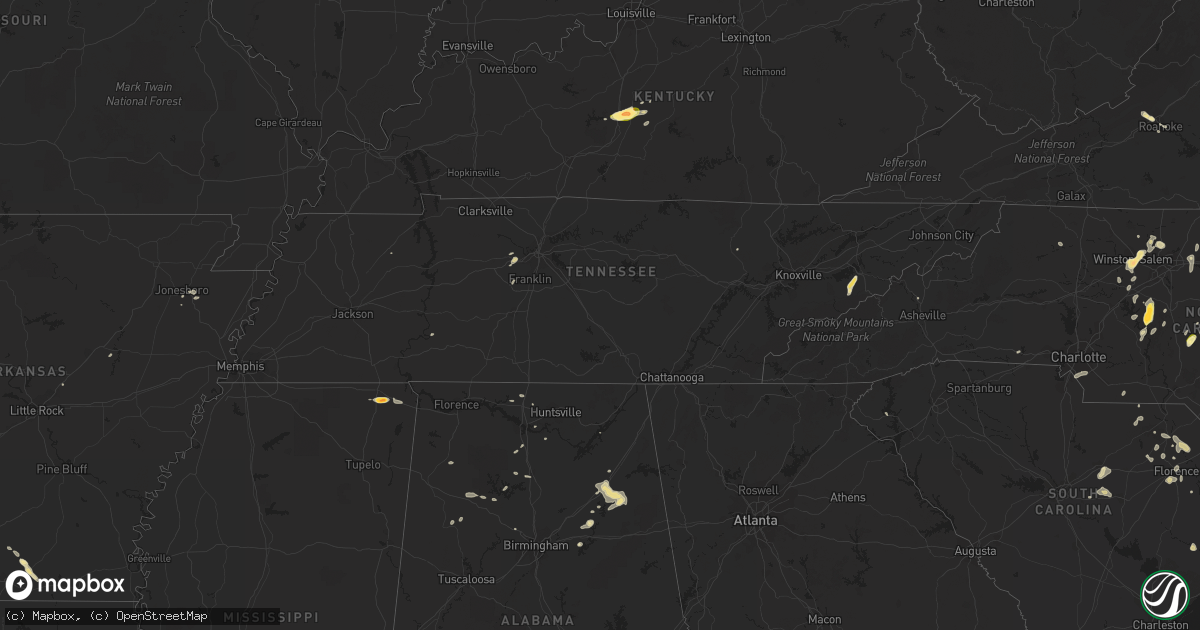
Hail Map in Tennessee on May 12, 2016
Get this storm
May 12 map
$229
one time, instant access
Download today. No call, no setup
Keep the $229
Bought the map and want the full workflow? Apply the entire $229 to a subscription within 7 days. None of it is wasted.
Every map, not just this one
This buys you this map. Subscription and you get every map we run, in the markets you choose from a few cities to whole states to nationwide. Plus real-time alerts the moment a storm fires.
Contact data
Name, contact info, occupancy, even credit band for addresses in the footprint. You go from where it hit to who to call.
Become the source they trust
Unlimited branding weather history reports on demand. You already have the documented answer ready for the property owner, and you are the one who showed up with it.
Property data and RoofTrace estimates
Pull up any address you have got, its value and the exact code rules for that jurisdiction, straight from One Click Code. Then RoofTrace estimates the squares, pitch, and roof value, priced the way you price.
Storm reports in Tennessee
Tennessee
| Date | Description |
|---|---|
| 05/12/20164:40 PM CDT | Few trees downed. |
| 05/12/20164:30 PM CDT | Tree downed. |
| 05/12/20163:55 PM CDT | A local report indicates 60 MPH wind near RUSSELLVILLE |
| 05/12/20163:50 PM CDT | A couple of trees down morristown and east side of morristown. |
| 05/12/20163:20 PM CDT | Several trees down across county. |
| 05/12/20163:15 PM CDT | Tree down along hwy 52 near moss |
| 05/12/20162:55 PM CDT | A couple of trees down halls area. |
| 05/12/20162:55 PM CDT | Several trees downed near and west of newport. |
| 05/12/20162:47 PM CDT | Tree down along union camp road |
| 05/12/20162:35 PM CDT | 2 trees down western part of knoxville |
| 05/12/20162:34 PM CDT | Several trees down...some down on homes |
| 05/12/20162:22 PM CDT | Trees down...one on a car and one caused minor damage to a home. |
| 05/12/20162:11 PM CDT | Several trees down...one on a house along hartsville pike. Powerlines down in and around lebanon. |
| 05/12/20162:06 PM CDT | A local report indicates 60 MPH wind near 3 E NASHVILLE |
| 05/12/20161:40 PM CDT | Several tree limbs down around shelby park |
| 05/12/20161:38 PM CDT | Trees and powerlines down at the corner of meridian and cleveland st. |
| 05/12/20161:35 PM CDT | Tree down at vantage way and french landing dr |
| 05/12/20161:34 PM CDT | A dozen trees down across the county. 2300 people without power. |
| 05/12/20161:34 PM CDT | Tree down at vantage way and french landing dr |
| 05/12/20161:34 PM CDT | Tree down on 3rd ave south. |
| 05/12/201612:55 PM CDT | A couple of trees down. |
| 05/12/201612:45 PM CDT | Several trees down across roads in the southwest part of the county. |
| 05/12/201612:28 PM CDT | Sign blown down near birdsong marina. Time estimated from radar. |
All States Impacted by Hail Map on May 12, 2016
Cities Impacted by Hail Map on May 12, 2016
- Sevierville, TN
- Cosby, TN
- Dandridge, TN
- Rocksprings, TX
- Del Rio, TX
- Walnut Cove, NC
- Glen, MS
- Corinth, MS
- Rienzi, MS
- El Dorado, AR
- Houston, TX
- Salem, VA
- Roanoke, VA
- Maple Hill, NC
- Ashville, AL
- Society Hill, SC
- Winston Salem, NC
- Richmond, TX
- Katy, TX
- Conway, SC
- Catawba, VA
- Fayetteville, NC
- Pineville, NC
- Matthews, NC
- Fort Mill, SC
- Charlotte, NC
- Hartsville, SC
- Darlington, SC
- Laurinburg, NC
- Maxton, NC
- Cropwell, AL
- Andrews, SC
- Logan, AL
- Cullman, AL
- Upton, KY
- Magnolia, KY
- Munfordville, KY
- Bonnieville, KY
- Parkton, NC
- Saint Pauls, NC
- Hope Mills, NC
- Shaw Afb, SC
- Rembert, SC
- Sumter, SC
- Dalzell, SC
- Pell City, AL
- Raeford, NC
- Denton, NC
- Lexington, NC
- Kingston Springs, TN
- Nashville, TN
- Pegram, TN
- Rainbow City, AL
- Gadsden, AL
- Attalla, AL
- Jacksonville, AL
- Wellington, AL
- Tow, TX
- Kenansville, NC
- Belews Creek, NC
- Stokesdale, NC
- Oak Ridge, NC
- Kernersville, NC
- Mount Sherman, KY
- Summersville, KY
- Troy, NC
- New London, NC
- Robbins, NC
- Carthage, NC
- Gouldbusk, TX
- Burnsville, MS
- Iuka, MS
- Hartselle, AL
- Ash, NC
- Hampton, AR
- Llano, TX
- Cherokee, TX
- San Saba, TX
- Summerfield, NC
- Myrtle Beach, SC
- Trinity, NC
- Cartersville, GA
- White, GA
- Athens, AL
- Ivanhoe, NC
- Asheboro, NC
- Star, NC
- Gibsonville, NC
- Whitsett, NC
- Eastover, SC
- Goldston, NC
- Madison, AL
- Currie, NC
- Atkinson, NC
- Langston, AL
- Strong, AR
- Timmonsville, SC
- Effingham, SC
- Eagle Springs, NC
- Carbon Hill, AL
- Berry, AL
- Palms, MI
- Marshville, NC
- Reese, MI
- Saginaw, MI
- Munger, MI
- North Wilkesboro, NC
- Roaring River, NC
- Walkertown, NC
- Apex, NC
- Pittsboro, NC
- Chapel Hill, NC
- Weiner, AR
- Shelby, NC
- Longwood, NC
- Arley, AL
- Crane Hill, AL
- Elon, NC
- Fairview, TN
- Nauvoo, AL
- Camden, SC
- Bald Knob, AR
- Bay City, MI
- Fairgrove, MI
- Carrollton, MI
- Hurdle Mills, NC
- Rougemont, NC
- Jasper, AL
- Cub Run, KY
- Pamplico, SC
- Hamer, SC
- Dillon, SC
- Florence, SC
- Franklin, TN
- Lancing, TN
- Advance, NC
- Port Austin, MI
- Campbellsville, KY
- Buffalo, KY
- Moncure, NC
- Rocky Point, NC
- Sidon, MS
- Vinton, VA
- Bear Creek, AL
- Garland, NC
- Gatlinburg, TN
- Fulshear, TX
- Rockwood, TX
- Rochelle, TX
- Lohn, TX
- Castle Hayne, NC
- Clifton, TN
- Little Rock, SC
- Rosenberg, TX
- Beasley, TX
- Bay, AR
- Fayette, AL
- Bankston, AL
- Cabot, AR
- Kingston, GA
- Harvest, AL
- Weaverville, NC
- Alexander, NC
- Elkmont, AL
- McKenzie, TN
- Elizabethtown, NC
- Tabor City, NC
- Loris, SC
- Falkville, AL
- Danville, AL
- Somerville, AL
- Laceys Spring, AL
- Hillsborough, NC
- Boaz, AL
- Ruby, SC
- Richfield, NC
- Seneca, SC
- Ragland, AL
- Julian, NC
- Albemarle, NC
- Jersey, AR
- Greensburg, KY
- Patrick, SC
- Blenheim, SC
- White Oak, NC
- Bennett, NC
- Hampstead, NC
- Jonesboro, AR
- Efland, NC
- McLeansville, NC
- Buchanan, GA
- Chesterfield, SC
- McBee, SC
- Lincoln, AL
- Altoona, AL
- Ohatchee, AL
- Shannon, NC
- Dora, AL
- Wilmington, NC
- Ronda, NC
- Mountain Rest, SC
- Tamassee, SC
- Walhalla, SC
- Salem, SC


