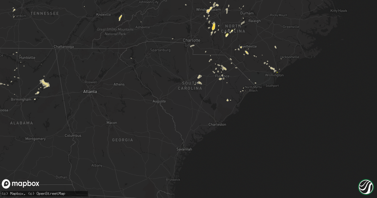
Hail Map in South Carolina on May 12, 2016
Get this storm
May 12 map
$229
one time, instant access
Download today. No call, no setup
Keep the $229
Bought the map and want the full workflow? Apply the entire $229 to a subscription within 7 days. None of it is wasted.
Every map, not just this one
This buys you this map. Subscription and you get every map we run, in the markets you choose from a few cities to whole states to nationwide. Plus real-time alerts the moment a storm fires.
Contact data
Name, contact info, occupancy, even credit band for addresses in the footprint. You go from where it hit to who to call.
Become the source they trust
Unlimited branding weather history reports on demand. You already have the documented answer ready for the property owner, and you are the one who showed up with it.
Property data and RoofTrace estimates
Pull up any address you have got, its value and the exact code rules for that jurisdiction, straight from One Click Code. Then RoofTrace estimates the squares, pitch, and roof value, priced the way you price.
Storm reports in South Carolina
South Carolina
| Date | Description |
|---|---|
| 05/12/20166:36 PM CDT | Power line down at sutton rd. And u.s. 21 intersection. |
| 05/12/20166:18 PM CDT | Approx 20 foot tree split by strong winds in simpsonville. |
| 05/12/20166:10 PM CDT | Tree fell on power line...causing power outage on n almond dr. |
| 05/12/20166:05 PM CDT | Tree down on harrison bridge rd at parkgate ct. |
| 05/12/20166:00 PM CDT | Large tree fell...blocking both lanes of dobbins ridge dr. Time estimated from radar. |
| 05/12/20165:38 PM CDT | Numerous trees and powerlines down. A few trees fell on houses. Trees down from piedmont to southeast of anderson. No known injuries. |
| 05/12/20165:22 PM CDT | Tree down on house and power lines down on west side of anderson. |
| 05/12/20165:15 PM CDT | Large tree fell...blocking both lanes of dobbins bridge rd. Time estimated from radar. |
| 05/12/20165:15 PM CDT | Kand asos measured a 51 kt gust. |
| 05/12/20163:27 PM CDT | Quarter size hail reported in the city of chesterfield. Report received via social media . |
| 05/12/20162:40 PM CDT | Multiple trees down some with tops broken off in an apparent microburst that affected the beacon ridge drive area. Trees fell on a house on beacon ridge drive. A few tr |
| 05/12/20162:30 PM CDT | Tree down at intersection of rochester hwy and w sizemore rd. |
| 05/12/20162:25 PM CDT | Quarter sized hail reported near intersection of w. John paul jones rd and meyers cementary road . |
| 05/12/20161:40 PM CDT | Quarter sized hail reported on highway 38 between blenheim and brownsville. |
| 05/12/20161:35 PM CDT | Dime size hail along north little river road at highway 30...with some larger stones as big as quarters. |
| 05/12/20161:22 PM CDT | Tree down dinkins mill rd and hwy 261. |
| 05/12/201612:56 PM CDT | 3 trees down reported at tomb field road camden sc |
| 05/12/201612:26 PM CDT | Tree down at horrell hill fd. Estmd 60 kt gust. Pea-size hail |
| 05/11/20169:23 PM CDT | Emergency manager reported two 50 foot hickory trees down. Time estimated by radar. |
| 05/11/20169:01 PM CDT | The allendale scdot office reported a tree down on hw-641 near the town of sycamore. |
| 05/11/20169:00 PM CDT | The allendale scdot office reported a tree down on williams road about 1 mile from hw-321. |
| 05/11/20168:52 PM CDT | The allendale county scdot office reported a tree down on hw-278 just outside of allendale. |
| 05/11/20168:52 PM CDT | The allendale scdot office reported a tree down on googe road closest to the end where it intersects with breezy hill road. |
| 05/11/20168:52 PM CDT | The allendale county scdot office reported a tree down on gum street west in allendale. |
All States Impacted by Hail Map on May 12, 2016
Cities Impacted by Hail Map on May 12, 2016
- Sevierville, TN
- Cosby, TN
- Dandridge, TN
- Rocksprings, TX
- Del Rio, TX
- Walnut Cove, NC
- Glen, MS
- Corinth, MS
- Rienzi, MS
- El Dorado, AR
- Houston, TX
- Salem, VA
- Roanoke, VA
- Maple Hill, NC
- Ashville, AL
- Society Hill, SC
- Winston Salem, NC
- Richmond, TX
- Katy, TX
- Conway, SC
- Catawba, VA
- Fayetteville, NC
- Pineville, NC
- Matthews, NC
- Fort Mill, SC
- Charlotte, NC
- Hartsville, SC
- Darlington, SC
- Laurinburg, NC
- Maxton, NC
- Cropwell, AL
- Andrews, SC
- Logan, AL
- Cullman, AL
- Upton, KY
- Magnolia, KY
- Munfordville, KY
- Bonnieville, KY
- Parkton, NC
- Saint Pauls, NC
- Hope Mills, NC
- Shaw Afb, SC
- Rembert, SC
- Sumter, SC
- Dalzell, SC
- Pell City, AL
- Raeford, NC
- Denton, NC
- Lexington, NC
- Kingston Springs, TN
- Nashville, TN
- Pegram, TN
- Rainbow City, AL
- Gadsden, AL
- Attalla, AL
- Jacksonville, AL
- Wellington, AL
- Tow, TX
- Kenansville, NC
- Belews Creek, NC
- Stokesdale, NC
- Oak Ridge, NC
- Kernersville, NC
- Mount Sherman, KY
- Summersville, KY
- Troy, NC
- New London, NC
- Robbins, NC
- Carthage, NC
- Gouldbusk, TX
- Burnsville, MS
- Iuka, MS
- Hartselle, AL
- Ash, NC
- Hampton, AR
- Llano, TX
- Cherokee, TX
- San Saba, TX
- Summerfield, NC
- Myrtle Beach, SC
- Trinity, NC
- Cartersville, GA
- White, GA
- Athens, AL
- Ivanhoe, NC
- Asheboro, NC
- Star, NC
- Gibsonville, NC
- Whitsett, NC
- Eastover, SC
- Goldston, NC
- Madison, AL
- Currie, NC
- Atkinson, NC
- Langston, AL
- Strong, AR
- Timmonsville, SC
- Effingham, SC
- Eagle Springs, NC
- Carbon Hill, AL
- Berry, AL
- Palms, MI
- Marshville, NC
- Reese, MI
- Saginaw, MI
- Munger, MI
- North Wilkesboro, NC
- Roaring River, NC
- Walkertown, NC
- Apex, NC
- Pittsboro, NC
- Chapel Hill, NC
- Weiner, AR
- Shelby, NC
- Longwood, NC
- Arley, AL
- Crane Hill, AL
- Elon, NC
- Fairview, TN
- Nauvoo, AL
- Camden, SC
- Bald Knob, AR
- Bay City, MI
- Fairgrove, MI
- Carrollton, MI
- Hurdle Mills, NC
- Rougemont, NC
- Jasper, AL
- Cub Run, KY
- Pamplico, SC
- Hamer, SC
- Dillon, SC
- Florence, SC
- Franklin, TN
- Lancing, TN
- Advance, NC
- Port Austin, MI
- Campbellsville, KY
- Buffalo, KY
- Moncure, NC
- Rocky Point, NC
- Sidon, MS
- Vinton, VA
- Bear Creek, AL
- Garland, NC
- Gatlinburg, TN
- Fulshear, TX
- Rockwood, TX
- Rochelle, TX
- Lohn, TX
- Castle Hayne, NC
- Clifton, TN
- Little Rock, SC
- Rosenberg, TX
- Beasley, TX
- Bay, AR
- Fayette, AL
- Bankston, AL
- Cabot, AR
- Kingston, GA
- Harvest, AL
- Weaverville, NC
- Alexander, NC
- Elkmont, AL
- McKenzie, TN
- Elizabethtown, NC
- Tabor City, NC
- Loris, SC
- Falkville, AL
- Danville, AL
- Somerville, AL
- Laceys Spring, AL
- Hillsborough, NC
- Boaz, AL
- Ruby, SC
- Richfield, NC
- Seneca, SC
- Ragland, AL
- Julian, NC
- Albemarle, NC
- Jersey, AR
- Greensburg, KY
- Patrick, SC
- Blenheim, SC
- White Oak, NC
- Bennett, NC
- Hampstead, NC
- Jonesboro, AR
- Efland, NC
- McLeansville, NC
- Buchanan, GA
- Chesterfield, SC
- McBee, SC
- Lincoln, AL
- Altoona, AL
- Ohatchee, AL
- Shannon, NC
- Dora, AL
- Wilmington, NC
- Ronda, NC
- Mountain Rest, SC
- Tamassee, SC
- Walhalla, SC
- Salem, SC


