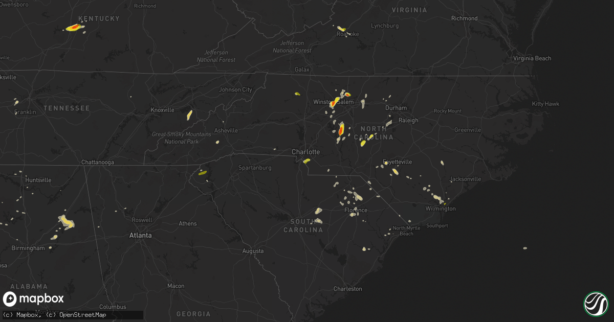
Hail Map on May 12, 2016
Get this storm
May 12 map
$229
one time, instant access
Download today. No call, no setup
Keep the $229
Bought the map and want the full workflow? Apply the entire $229 to a subscription within 7 days. None of it is wasted.
Every map, not just this one
This buys you this map. Subscription and you get every map we run, in the markets you choose from a few cities to whole states to nationwide. Plus real-time alerts the moment a storm fires.
Contact data
Name, contact info, occupancy, even credit band for addresses in the footprint. You go from where it hit to who to call.
Become the source they trust
Unlimited branding weather history reports on demand. You already have the documented answer ready for the property owner, and you are the one who showed up with it.
Property data and RoofTrace estimates
Pull up any address you have got, its value and the exact code rules for that jurisdiction, straight from One Click Code. Then RoofTrace estimates the squares, pitch, and roof value, priced the way you price.
States Impacted by Hail Map on May 12, 2016
Storm reports
Virginia
| Date | Description |
|---|---|
| 05/12/20165:50 PM CDT | A few trees down across the eastern half of russell county... Va. |
| 05/12/20165:40 PM CDT | Trees down near the city of abingdon... Va. |
| 05/12/20165:10 PM CDT | Multiple trees down just west of bristol va. |
| 05/12/20165:10 PM CDT | Multiple trees down castlewood area |
| 05/12/20164:15 PM CDT | A few trees down in big stone gap area and elsewhere in county. |
| 05/12/20163:16 PM CDT | Large tree limbs down. |
| 05/12/20162:32 PM CDT | Large tree limbs down. Penny sized hail as well. |
| 05/12/20162:30 PM CDT | A local report indicates 1.25 inch wind near 5 NW ROANOKE |
Mississippi
| Date | Description |
|---|---|
| 05/12/20164:25 PM CDT | A couple of trees knocked down and a light pole snapped in two on county road 261 in bissel. |
| 05/12/20163:11 PM CDT | Brief golfball size hail. Caused damage to a vehicle. Time is radar estimated. |
| 05/12/20163:11 PM CDT | Utility lines down on county road 300 near town of glen. |
| 05/12/20163:08 PM CDT | Two trees downed on county road 185 right by greenwood-leflore airport. One tree downed northwest of the airport on highway 82 near the carroll and leflore county line. |
South Carolina
| Date | Description |
|---|---|
| 05/12/20166:36 PM CDT | Power line down at sutton rd. And u.s. 21 intersection. |
| 05/12/20166:18 PM CDT | Approx 20 foot tree split by strong winds in simpsonville. |
| 05/12/20166:10 PM CDT | Tree fell on power line...causing power outage on n almond dr. |
| 05/12/20166:05 PM CDT | Tree down on harrison bridge rd at parkgate ct. |
| 05/12/20166:00 PM CDT | Large tree fell...blocking both lanes of dobbins ridge dr. Time estimated from radar. |
| 05/12/20165:38 PM CDT | Numerous trees and powerlines down. A few trees fell on houses. Trees down from piedmont to southeast of anderson. No known injuries. |
| 05/12/20165:22 PM CDT | Tree down on house and power lines down on west side of anderson. |
| 05/12/20165:15 PM CDT | Kand asos measured a 51 kt gust. |
| 05/12/20165:15 PM CDT | Large tree fell...blocking both lanes of dobbins bridge rd. Time estimated from radar. |
| 05/12/20163:27 PM CDT | Quarter size hail reported in the city of chesterfield. Report received via social media . |
| 05/12/20162:40 PM CDT | Multiple trees down some with tops broken off in an apparent microburst that affected the beacon ridge drive area. Trees fell on a house on beacon ridge drive. A few tr |
| 05/12/20162:30 PM CDT | Tree down at intersection of rochester hwy and w sizemore rd. |
| 05/12/20162:25 PM CDT | Quarter sized hail reported near intersection of w. John paul jones rd and meyers cementary road . |
| 05/12/20161:40 PM CDT | Quarter sized hail reported on highway 38 between blenheim and brownsville. |
| 05/12/20161:35 PM CDT | Dime size hail along north little river road at highway 30...with some larger stones as big as quarters. |
| 05/12/20161:22 PM CDT | Tree down dinkins mill rd and hwy 261. |
| 05/12/201612:56 PM CDT | 3 trees down reported at tomb field road camden sc |
| 05/12/201612:26 PM CDT | Tree down at horrell hill fd. Estmd 60 kt gust. Pea-size hail |
| 05/11/20169:23 PM CDT | Emergency manager reported two 50 foot hickory trees down. Time estimated by radar. |
| 05/11/20169:01 PM CDT | The allendale scdot office reported a tree down on hw-641 near the town of sycamore. |
| 05/11/20169:00 PM CDT | The allendale scdot office reported a tree down on williams road about 1 mile from hw-321. |
| 05/11/20168:52 PM CDT | The allendale county scdot office reported a tree down on hw-278 just outside of allendale. |
| 05/11/20168:52 PM CDT | The allendale scdot office reported a tree down on googe road closest to the end where it intersects with breezy hill road. |
| 05/11/20168:52 PM CDT | The allendale county scdot office reported a tree down on gum street west in allendale. |
Arkansas
| Date | Description |
|---|---|
| 05/12/20168:05 AM CDT | Numerous trees down in and around augusta with some uprooted. A lone metal outbuilding was damaged. |
| 05/12/20167:30 AM CDT | A few small trees down near highway 38. |
| 05/12/20167:28 AM CDT | A few small trees down with numerous branches down as well. |
| 05/12/20167:15 AM CDT | Tree reported down at greystone. |
| 05/12/20167:15 AM CDT | Large tree reported down. |
| 05/12/20167:05 AM CDT | Tree reported down near batesville pike and frenchman mountain rd. |
| 05/12/20167:05 AM CDT | Large tree limbs down near batesville pike with one large limb on a home. |
| 05/12/20167:05 AM CDT | Large tree limbs down. |
| 05/12/20167:04 AM CDT | Tree reported down along camp robinson road near remount. |
Michigan
| Date | Description |
|---|---|
| 05/12/20163:15 PM CDT | Delayed report: dime size hail fell and covered the ground. A tree was blown over along 28 mile road... Which downed some powerlines. Power outages lasted approximately 8 (gr |
Texas
| Date | Description |
|---|---|
| 05/12/20166:50 PM CDT | Quarter size hail observed about halfway between hwy 377 and cr674 |
| 05/11/20169:07 PM CDT | Quarter size hail near the intersection of south fry road and kingsland blvd |
| 05/11/20168:13 PM CDT | Quarter to golf ball size hail in lakeview drive area of jersey village that fell for around 20 minutes |
| 05/11/20168:13 PM CDT | Quarter size hail |
| 05/11/20167:09 PM CDT | A local report indicates 1.75 inch wind near 5 NW ROCKSPRINGS |
Tennessee
| Date | Description |
|---|---|
| 05/12/20164:40 PM CDT | Few trees downed. |
| 05/12/20164:30 PM CDT | Tree downed. |
| 05/12/20163:55 PM CDT | A local report indicates 60 MPH wind near RUSSELLVILLE |
| 05/12/20163:50 PM CDT | A couple of trees down morristown and east side of morristown. |
| 05/12/20163:20 PM CDT | Several trees down across county. |
| 05/12/20163:15 PM CDT | Tree down along hwy 52 near moss |
| 05/12/20162:55 PM CDT | A couple of trees down halls area. |
| 05/12/20162:55 PM CDT | Several trees downed near and west of newport. |
| 05/12/20162:47 PM CDT | Tree down along union camp road |
| 05/12/20162:35 PM CDT | 2 trees down western part of knoxville |
| 05/12/20162:34 PM CDT | Several trees down...some down on homes |
| 05/12/20162:22 PM CDT | Trees down...one on a car and one caused minor damage to a home. |
| 05/12/20162:11 PM CDT | Several trees down...one on a house along hartsville pike. Powerlines down in and around lebanon. |
| 05/12/20162:06 PM CDT | A local report indicates 60 MPH wind near 3 E NASHVILLE |
| 05/12/20161:40 PM CDT | Several tree limbs down around shelby park |
| 05/12/20161:38 PM CDT | Trees and powerlines down at the corner of meridian and cleveland st. |
| 05/12/20161:35 PM CDT | Tree down at vantage way and french landing dr |
| 05/12/20161:34 PM CDT | Tree down at vantage way and french landing dr |
| 05/12/20161:34 PM CDT | Tree down on 3rd ave south. |
| 05/12/20161:34 PM CDT | A dozen trees down across the county. 2300 people without power. |
| 05/12/201612:55 PM CDT | A couple of trees down. |
| 05/12/201612:45 PM CDT | Several trees down across roads in the southwest part of the county. |
| 05/12/201612:28 PM CDT | Sign blown down near birdsong marina. Time estimated from radar. |
Alabama
| Date | Description |
|---|---|
| 05/12/20165:59 PM CDT | Tree down near maple hill cemetery. |
| 05/12/20165:44 PM CDT | Tree down along smith vasser road... South of yarbrough road. |
| 05/12/20165:40 PM CDT | A few large limbs were downed by thunderstorm winds. |
| 05/12/20165:37 PM CDT | Trained spotter measured a wind gust of 62mph. He is located just north of athens state university. |
| 05/12/20165:36 PM CDT | A tree was downed by thunderstorm winds at copeland and east limestone roads. |
| 05/12/20165:33 PM CDT | A few trees and power lines downed by thunderstorm winds at highway 70a between highway 251 and sharp road. |
| 05/12/20165:30 PM CDT | Numerous trees downed by thunderstorm winds. |
| 05/12/20165:30 PM CDT | Numberous trees were downed and uprooted by thunderstorm winds. |
| 05/12/20165:26 PM CDT | A few large limbs snapped by thunderstorm winds. |
| 05/12/20165:24 PM CDT | A few large limbs were snapped by thunderstorm winds. |
| 05/12/20161:00 PM CDT | Large tree limb down and blocking piney branch rd. Time is radar estimated. |
North Carolina
| Date | Description |
|---|---|
| 05/12/20166:55 PM CDT | A power line was blown down. |
| 05/12/20166:52 PM CDT | Multiple trees down near n.c. 51 and n.c. 16. Time estimated by radar. |
| 05/12/20166:48 PM CDT | A local report indicates 1.00 inch wind near 2 E PINEVILLE |
| 05/12/20166:26 PM CDT | Several trees reported down near altamahaw. Time estimated by radar. |
| 05/12/20166:08 PM CDT | 2 trees reported down at coble church road. |
| 05/12/20165:45 PM CDT | A local report indicates 1.00 inch wind near 2 E STOKESDALE |
| 05/12/20165:45 PM CDT | A tree was blown down at the intersection of witty road and spring creek road. |
| 05/12/20165:30 PM CDT | One tree down across highway 311. |
| 05/12/20165:16 PM CDT | At least two trees down and a flagpole near casar- belwood road. |
| 05/12/20165:15 PM CDT | Trees reported down on oak grove rd near moss lake...borders rd...and n post rd. |
| 05/12/20165:08 PM CDT | Numerous trees and power lines down on the east side of winston-salem. Time approximate... Estimated by radar. |
| 05/12/20165:05 PM CDT | Several trees down around property and shutters torn off home. |
| 05/12/20164:58 PM CDT | Up to golf ball size hail near winston-salem state university. Time estimated by radar. |
| 05/12/20164:40 PM CDT | On farmer denton road |
| 05/12/20164:35 PM CDT | Wind damage near the casar-belwood rd and hull rd intersection including two downed trees and flag pole bent at 90-degree angle. |
| 05/12/20164:30 PM CDT | Quarter size hail reported near robbins by sherriff in the area at the time. |
| 05/12/20164:19 PM CDT | Up to golf ball size hail reported on social media. Time estimated by radar. |
| 05/12/20164:10 PM CDT | Hail up to quarter size. |
| 05/12/20163:35 PM CDT | Report of quarter sized hail in brittany lakes. |
| 05/12/20162:47 PM CDT | Hail up to quarter size on ruritan road |
| 05/12/20161:10 PM CDT | Trees down on galatia church rd. Reported by hoke county dot. |
| 05/11/20167:10 PM CDT | Reports of numerous trees down in the matthews and indian trail areas. |
Kentucky
| Date | Description |
|---|---|
| 05/12/20163:03 PM CDT | A local report indicates 1.75 inch wind near HAMMONVILLE |
| 05/12/20162:46 PM CDT | A local report indicates 1.00 inch wind near 2 ENE PRICEVILLE |
Cities Impacted by Hail Map on May 12, 2016
- Sevierville, TN
- Cosby, TN
- Dandridge, TN
- Rocksprings, TX
- Del Rio, TX
- Walnut Cove, NC
- Glen, MS
- Corinth, MS
- Rienzi, MS
- El Dorado, AR
- Houston, TX
- Salem, VA
- Roanoke, VA
- Maple Hill, NC
- Ashville, AL
- Society Hill, SC
- Winston Salem, NC
- Richmond, TX
- Katy, TX
- Conway, SC
- Catawba, VA
- Fayetteville, NC
- Pineville, NC
- Matthews, NC
- Fort Mill, SC
- Charlotte, NC
- Hartsville, SC
- Darlington, SC
- Laurinburg, NC
- Maxton, NC
- Cropwell, AL
- Andrews, SC
- Logan, AL
- Cullman, AL
- Upton, KY
- Magnolia, KY
- Munfordville, KY
- Bonnieville, KY
- Parkton, NC
- Saint Pauls, NC
- Hope Mills, NC
- Shaw Afb, SC
- Rembert, SC
- Sumter, SC
- Dalzell, SC
- Pell City, AL
- Raeford, NC
- Denton, NC
- Lexington, NC
- Kingston Springs, TN
- Nashville, TN
- Pegram, TN
- Rainbow City, AL
- Gadsden, AL
- Attalla, AL
- Jacksonville, AL
- Wellington, AL
- Tow, TX
- Kenansville, NC
- Belews Creek, NC
- Stokesdale, NC
- Oak Ridge, NC
- Kernersville, NC
- Mount Sherman, KY
- Summersville, KY
- Troy, NC
- New London, NC
- Robbins, NC
- Carthage, NC
- Gouldbusk, TX
- Burnsville, MS
- Iuka, MS
- Hartselle, AL
- Ash, NC
- Hampton, AR
- Llano, TX
- Cherokee, TX
- San Saba, TX
- Summerfield, NC
- Myrtle Beach, SC
- Trinity, NC
- Cartersville, GA
- White, GA
- Athens, AL
- Ivanhoe, NC
- Asheboro, NC
- Star, NC
- Gibsonville, NC
- Whitsett, NC
- Eastover, SC
- Goldston, NC
- Madison, AL
- Currie, NC
- Atkinson, NC
- Langston, AL
- Strong, AR
- Timmonsville, SC
- Effingham, SC
- Eagle Springs, NC
- Carbon Hill, AL
- Berry, AL
- Palms, MI
- Marshville, NC
- Reese, MI
- Saginaw, MI
- Munger, MI
- North Wilkesboro, NC
- Roaring River, NC
- Walkertown, NC
- Apex, NC
- Pittsboro, NC
- Chapel Hill, NC
- Weiner, AR
- Shelby, NC
- Longwood, NC
- Arley, AL
- Crane Hill, AL
- Elon, NC
- Fairview, TN
- Nauvoo, AL
- Camden, SC
- Bald Knob, AR
- Bay City, MI
- Fairgrove, MI
- Carrollton, MI
- Hurdle Mills, NC
- Rougemont, NC
- Jasper, AL
- Cub Run, KY
- Pamplico, SC
- Hamer, SC
- Dillon, SC
- Florence, SC
- Franklin, TN
- Lancing, TN
- Advance, NC
- Port Austin, MI
- Campbellsville, KY
- Buffalo, KY
- Moncure, NC
- Rocky Point, NC
- Sidon, MS
- Vinton, VA
- Bear Creek, AL
- Garland, NC
- Gatlinburg, TN
- Fulshear, TX
- Rockwood, TX
- Rochelle, TX
- Lohn, TX
- Castle Hayne, NC
- Clifton, TN
- Little Rock, SC
- Rosenberg, TX
- Beasley, TX
- Bay, AR
- Fayette, AL
- Bankston, AL
- Cabot, AR
- Kingston, GA
- Harvest, AL
- Weaverville, NC
- Alexander, NC
- Elkmont, AL
- McKenzie, TN
- Elizabethtown, NC
- Tabor City, NC
- Loris, SC
- Falkville, AL
- Danville, AL
- Somerville, AL
- Laceys Spring, AL
- Hillsborough, NC
- Boaz, AL
- Ruby, SC
- Richfield, NC
- Seneca, SC
- Ragland, AL
- Julian, NC
- Albemarle, NC
- Jersey, AR
- Greensburg, KY
- Patrick, SC
- Blenheim, SC
- White Oak, NC
- Bennett, NC
- Hampstead, NC
- Jonesboro, AR
- Efland, NC
- McLeansville, NC
- Buchanan, GA
- Chesterfield, SC
- McBee, SC
- Lincoln, AL
- Altoona, AL
- Ohatchee, AL
- Shannon, NC
- Dora, AL
- Wilmington, NC
- Ronda, NC
- Mountain Rest, SC
- Tamassee, SC
- Walhalla, SC
- Salem, SC