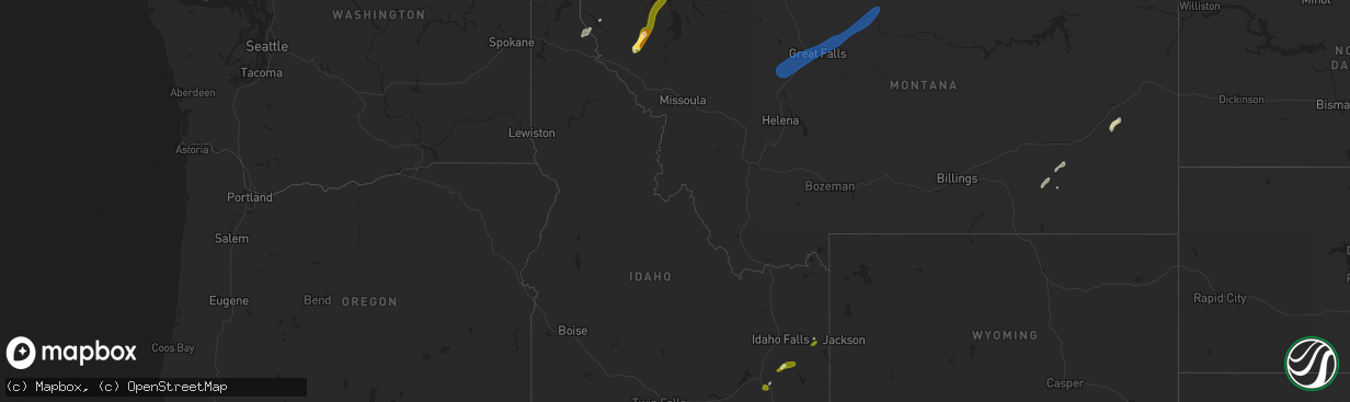
Hail Map in Idaho on May 11, 2025
The weather event in Idaho on May 11, 2025 includes Hail and Wind maps. 7 states and 48 cities were impacted and suffered possible damage. The total estimated number of properties impacted is 340.
Want more than just the map?
Turn this storm into a full workflow.
- Owner + property data so you know who to knock
- OnDemand branded weather history reports to win the "did we even have hail?" argument
- RoofTrace estimate so reps stop guessing numbers at the door
Bought this map? Upgrade within 7 days and we'll credit the $230. (10-15 min setup call)
Hail
Wind
340
Estimated number of impacted properties by a 1.00" hail or larger0
Estimated number of impacted properties by a 1.75" hail or larger0
Estimated number of impacted properties by a 2.50" hail or largerStorm reports in Idaho
Idaho
| Date | Description |
|---|---|
| 05/11/20256:50 PM CDT | Mesonet station ham. |
| 05/11/20256:45 PM CDT | 2979 botts id-33. |
| 05/11/20256:35 PM CDT | Mesonet station ter. |
| 05/11/20256:25 PM CDT | Mesonet station rov. |
| 05/11/20256:10 PM CDT | Mesonet station ebr inl materials fuels complex. |
| 05/11/20256:00 PM CDT | Mesonet station pbf inl critical infrastructure. |
| 05/11/20256:00 PM CDT | 3699 inl puzzle us-20/us-26. |
| 05/11/20255:45 PM CDT | Mesonet station tgfi1 trail gulch. |
| 05/11/20255:40 PM CDT | Pc371 medicine lodge. |
| 05/11/20254:50 PM CDT | Asos station kllj challis airport. |
| 05/11/20254:44 PM CDT | Asos station kpih pocatello regional airport. |
| 05/11/20254:43 PM CDT | Mesonet station hpfi1 horton peak. |
| 05/11/20254:15 PM CDT | Mbwbt mount baird. |
| 05/11/20254:15 PM CDT | Mesonet station itde5 d6 palisades dam us-26. |
| 05/11/20254:14 PM CDT | Several trees down in the game creek area off of old jackson highway. Time estimated based on radar. |
| 05/11/20254:09 PM CDT | Estimated 60-70 mph winds over pine creek pass. Time estimated based on radar. |
| 05/11/20254:01 PM CDT | Via facebook. Time estimated by radar. |
| 05/11/20254:00 PM CDT | Mesonet station sldmt 9.8 nw soldier |
| 05/11/20253:55 PM CDT | Measured along id-34 near blackfoot river rd. |
| 05/11/20253:30 PM CDT | Mesonet station pc506 sheep creek hills. |
| 05/11/20253:02 PM CDT | Mesonet station tt087 saylor creek. |
| 05/11/20252:58 PM CDT | Asos station ktwf twin falls. |
| 05/11/20252:54 PM CDT | Measured near the intersection of id-77 and narrows rd. |
| 05/11/20252:51 PM CDT | Photo and video submitted of estimated quarter size hail falling just west of inkom. Time estimated based on radar. |
| 05/11/20252:45 PM CDT | Mesonet station 3251 d4 - hansen bridge. |
| 05/11/20251:40 PM CDT | Mesonet station 690 inl central facilities. |
| 05/11/20251:15 PM CDT | Mesonet station 2983 d4 conner summit id-77. |
| 05/10/20258:00 PM CDT | Several trees uprooted at rigby pioneer cemetery. Time of event estimated based on radar. |
| 05/10/20258:00 PM CDT | A 2 to 3 foot diameter tree uprooted. |
| 05/10/20257:30 PM CDT | A local report indicates 1.00 inch wind near Pinehurst |
Cities Impacted by Hail Map on May 11, 2025
- Myakka City, FL
- Bradenton, FL
- Parrish, FL
- American Falls, ID
- Wimauma, FL
- Pocatello, ID
- Mccammon, ID
- Inkom, ID
- Lawrence, MS
- Louin, MS
- Firth, ID
- Lake, MS
- Raleigh, MS
- Macon, MS
- Sallis, MS
- Brooksville, MS
- Jackson, AL
- Swan Valley, ID
- Butler, AL
- Sweet Water, AL
- Cascade, MT
- Wolf Creek, MT
- Augusta, MT
- Great Falls, MT
- Ulm, MT
- Sun River, MT
- Black Eagle, MT
- Floweree, MT
- Highwood, MT
- Fort Benton, MT
- Big Sandy, MT
- Loma, MT
- Forsyth, MT
- Indianola, MS
- Leland, MS
- Divide, CO
- Lame Deer, MT
- Kingston, ID
- Ismay, MT
- Trout Creek, MT
- Mirando City, TX
- Plains, MT
- Hot Springs, MT
- Lonepine, MT
- Marion, MT
- Kila, MT
- Kalispell, MT
- Columbia Falls, MT


