Hail Map on May 11, 2025
The weather event on May 11, 2025 includes Hail and Wind maps. 7 states and 48 cities were impacted and suffered possible damage. The total estimated number of properties impacted is 8,063.
Want more than just the map?
Turn this storm into a full workflow.
- Owner + property data so you know who to knock
- OnDemand branded weather history reports to win the "did we even have hail?" argument
- RoofTrace estimate so reps stop guessing numbers at the door
Bought this map? Upgrade within 7 days and we'll credit the $230. (10-15 min setup call)
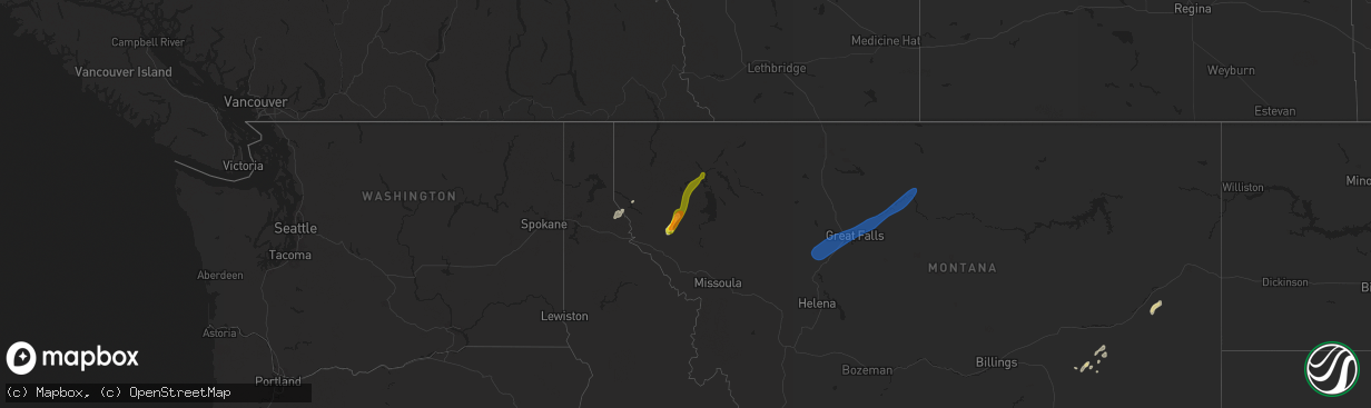
Hail
Wind
8,063
Estimated number of impacted properties by a 1.00" hail or larger0
Estimated number of impacted properties by a 1.75" hail or larger0
Estimated number of impacted properties by a 2.50" hail or largerStorm reports
Florida
| Date | Description |
|---|---|
| 05/11/20258:49 AM CDT | Fallen trees or limbs resulted in a power outage along obediah triplett road. |
Montana
| Date | Description |
|---|---|
| 05/11/20255:55 PM CDT | Montana mesonet station big sandy se. |
| 05/11/20254:20 PM CDT | Corrects previous non-tstm wnd dmg report from 2 sw great falls to tstm wnd dmg. Large conifer tree snapped and down on cherry dr in fox farm area. |
| 05/11/20254:07 PM CDT | 59 mph gust at ambient weather station. |
| 05/11/20254:06 PM CDT | 63 mph gust at ambient weather station. |
| 05/11/20254:05 PM CDT | 58 mph gust at ambiient weather station. |
| 05/11/20253:53 PM CDT | 68 mph gust measured at nws great falls. |
| 05/11/20253:00 PM CDT | A local report indicates 58 MPH wind near 3 NW Cooney Reservoir |
| 05/11/202512:55 AM CDT | Reported lots of hail ranging in size from pea size to golf balls. |
| 05/10/20258:29 PM CDT | Mesonet station hbom8 hillsboro. |
| 05/10/20257:15 PM CDT | Mesonet station mthcd home creek divide us-212 mp 81.5. |
| 05/10/20257:01 PM CDT | Mesonet station bafm8 badger peak. |
Wyoming
| Date | Description |
|---|---|
| 05/11/20256:30 PM CDT | Mesonet station pc462 irma lake. |
| 05/11/20256:30 PM CDT | Mesonet station pc261 cedar mountain. |
| 05/11/20256:26 PM CDT | Mesonet station krec red canyon - south pass. |
| 05/11/20256:20 PM CDT | Mesonet station pc395 shoshone southfork. |
| 05/11/20256:20 PM CDT | Mesonet station pc462 irma lake. |
| 05/11/20255:52 PM CDT | Mesonet station wy42 farson |
| 05/11/20254:36 PM CDT | Awos station kjac jackson hole airport. |
| 05/11/20254:10 PM CDT | Mesonet station pc450 evanston north. |
| 05/11/20253:42 PM CDT | Mesonet station gcrw4 meeteetse 10 s. |
| 05/11/20252:23 PM CDT | Awos station kdub dubois airport. |
| 05/11/20252:23 PM CDT | Awos station kdub dubois airport. -tooele valley airport. |
| 05/11/20251:30 PM CDT | Mesonet station pc450 evanston north. |
| 05/10/20258:19 PM CDT | A local report indicates 62 MPH wind near 17 NNW New Haven |
| 05/10/20257:15 PM CDT | Awos station kpoy powell airport. |
South Carolina
| Date | Description |
|---|---|
| 05/11/20252:33 AM CDT | Scdps reports a tree across sudlow lake rd north of augusta... Ga. |
| 05/11/20252:28 AM CDT | Scdps reports a tree down near intersection of parker dr and old cherokee dr west of langley. |
| 05/11/20252:20 AM CDT | Corrects previous tstm wnd dmg report from 1 ne burnettown. Langley fire department reports their station has 2 bay doors ripped off. Time estimated from radar. |
| 05/11/20252:20 AM CDT | Spotter reports of numerous trees and powerlines down on homes in langley near langley pond along highway 421. |
South Dakota
| Date | Description |
|---|---|
| 05/10/20257:20 PM CDT | A local report indicates 66 MPH wind near 1 ENE Mud Butte |
Georgia
| Date | Description |
|---|---|
| 05/11/20251:20 PM CDT | Report from emergency manager of a mobile home knocked off its foundation in west broxton. Time estimated via radar. |
Mississippi
| Date | Description |
|---|---|
| 05/11/20254:50 PM CDT | 2-2.5 foot diameter elm tree snapped and fell on the roof of a house causing mostly exterior damage. No hail nor rain was occurring during the time of the tree snapping |
North Dakota
| Date | Description |
|---|---|
| 05/10/202510:55 PM CDT | Elgin 10nw |
| 05/10/202510:11 PM CDT | Mesonet station tt584 12 e mott. |
| 05/10/202510:10 PM CDT | New leipzig ess nd dot site. |
| 05/10/20259:28 PM CDT | Asos station khei hettinger airport. |
| 05/10/20259:23 PM CDT | Hettinger nw |
| 05/10/20257:03 PM CDT | Corrects previous tstm wnd gst report from 4n bowman. The correct observation is 4w bowman ndawn. Reading at 10 meters. |
| 05/10/20257:03 PM CDT | 4n bowman ndawn. Reading at 10 meters. |
Utah
| Date | Description |
|---|---|
| 05/11/20256:20 PM CDT | Mesonet station utgrs i-80 at grassey. |
| 05/11/20254:40 PM CDT | Mesonet station pc490 kennecott rd lake point. |
| 05/11/20254:35 PM CDT | Awos station ktvy bolinder field-tooele valley airport. |
| 05/11/20254:25 PM CDT | Mesonet station dpg14 wig mountain. |
| 05/11/20254:12 PM CDT | Mesonet station as768 great salt lake marina. |
| 05/11/20254:10 PM CDT | Mesonet station pc490 kennecott rd lake point. |
| 05/11/20254:10 PM CDT | Mesonet station utkno i-80 at mp 40 knolls. |
| 05/11/20254:00 PM CDT | Mesonet station ut201 sr-201 at i-80. |
| 05/11/20254:00 PM CDT | Mesonet station sbt15 snowbasin - strawberry tower 15. |
| 05/11/20254:00 PM CDT | Mesonet station pc104 grantsville south. |
| 05/11/20253:58 PM CDT | Wind gust of 75 for 20-30 seconds. |
| 05/11/20253:55 PM CDT | Mesonet station kcc02 marina. |
| 05/11/20253:50 PM CDT | Mesonet station utkno i-80 at mp 40 knolls. |
| 05/11/20253:40 PM CDT | Mesonet station utkno i-80 at mp 40 knolls. |
| 05/11/20253:29 PM CDT | Mesonet station ur434 strnsw. |
| 05/11/20253:17 PM CDT | Large trees down. Reported with pictures via social media. |
| 05/11/20253:10 PM CDT | Mesonet station utkno i-80 at mp 40 knolls. |
| 05/11/20253:00 PM CDT | Mesonet station ew2533 bountiful bench. |
| 05/11/20252:56 PM CDT | Mesonet station fw8325 garden city. |
| 05/11/20252:50 PM CDT | Mesonet station utedl i-80 at mp 71 east delle. |
| 05/11/20252:50 PM CDT | Mesonet station uteur us-6 at eureka. |
| 05/11/20252:48 PM CDT | Mesonet station as768 great salt lake marina. |
| 05/11/20252:37 PM CDT | Mesonet station ur305 27.0 e lucin. |
| 05/11/20252:32 PM CDT | Intense wind blowing trees... Breaking tree parts... Damaging household parts outside. |
| 05/11/20252:30 PM CDT | Mesonet station ut33 i-80 at mp 29. |
| 05/11/20252:30 PM CDT | Mesonet station ut28 tremonton. |
| 05/11/20252:20 PM CDT | Mesonet station ut201 sr-201 at i-80. |
| 05/11/20252:20 PM CDT | Mesonet station pc492 radar. |
| 05/11/20252:15 PM CDT | Mesonet station freut fremont island - miller hill. |
| 05/11/20252:10 PM CDT | Mesonet station pc490 kennecott rd lake point. |
| 05/11/20252:10 PM CDT | Mesonet station ut9 lake point i-80. |
| 05/11/20252:09 PM CDT | Mesonet station up068 marsh. |
| 05/11/20252:00 PM CDT | Mesonet station uucmf uofu compass minerals flux tower. |
| 05/11/20251:50 PM CDT | Mesonet station pc104 grantsville south. |
| 05/11/20251:50 PM CDT | Large tree down with root ball in grantsville. Reported via social media picture. |
| 05/11/20251:45 PM CDT | Mesonet station lmr lakeside mountain. |
| 05/11/20251:30 PM CDT | Mesonet station vrh vernon hill. |
| 05/11/20251:10 PM CDT | Mesonet station utbig big mountain pass. |
| 05/11/20251:00 PM CDT | Mesonet station utkno i-80 at mp 40 knolls. |
| 05/11/20251:00 PM CDT | Mesonet station dpg17 interstate 80. |
| 05/11/20251:00 PM CDT | Semi roll over reported near mp 33. |
| 05/11/202512:50 PM CDT | Mesonet station dpg24 w of wildcat. |
| 05/10/20259:30 PM CDT | Mesonet station utusu us-89 at usu. |
| 05/10/20258:40 PM CDT | Mesonet station utckh chaulk hill. |
| 05/10/20258:35 PM CDT | Recorded at the south valley regional airport. |
| 05/10/20258:30 PM CDT | Mesonet station wjdnb west jordan bench. |
| 05/10/20258:30 PM CDT | Mesonet station utdwy sr-85 at dannon way. |
| 05/10/20258:15 PM CDT | Mesonet station gslm great salt lake minerals. |
| 05/10/20258:00 PM CDT | Mesonet station utedl i-80 at mp 71 east delle. |
| 05/10/20258:00 PM CDT | Recorded at the u of u compass minerals flux tower site. Microburst associated with a high based shower. |
| 05/10/20257:20 PM CDT | Mesonet station utwdl i-80 at mp 68 west delle. |
| 05/10/20257:10 PM CDT | Mesonet station pc123 murray's hill. |
| 05/10/20257:03 PM CDT | Pacificorp site pc492. |
| 05/10/20257:00 PM CDT | Mesonet station utgrs i-80 at grassey. |
Idaho
| Date | Description |
|---|---|
| 05/11/20256:50 PM CDT | Mesonet station ham. |
| 05/11/20256:45 PM CDT | 2979 botts id-33. |
| 05/11/20256:35 PM CDT | Mesonet station ter. |
| 05/11/20256:25 PM CDT | Mesonet station rov. |
| 05/11/20256:10 PM CDT | Mesonet station ebr inl materials fuels complex. |
| 05/11/20256:00 PM CDT | 3699 inl puzzle us-20/us-26. |
| 05/11/20256:00 PM CDT | Mesonet station pbf inl critical infrastructure. |
| 05/11/20255:45 PM CDT | Mesonet station tgfi1 trail gulch. |
| 05/11/20255:40 PM CDT | Pc371 medicine lodge. |
| 05/11/20254:50 PM CDT | Asos station kllj challis airport. |
| 05/11/20254:44 PM CDT | Asos station kpih pocatello regional airport. |
| 05/11/20254:43 PM CDT | Mesonet station hpfi1 horton peak. |
| 05/11/20254:15 PM CDT | Mbwbt mount baird. |
| 05/11/20254:15 PM CDT | Mesonet station itde5 d6 palisades dam us-26. |
| 05/11/20254:14 PM CDT | Several trees down in the game creek area off of old jackson highway. Time estimated based on radar. |
| 05/11/20254:09 PM CDT | Estimated 60-70 mph winds over pine creek pass. Time estimated based on radar. |
| 05/11/20254:01 PM CDT | Via facebook. Time estimated by radar. |
| 05/11/20254:00 PM CDT | Mesonet station sldmt 9.8 nw soldier |
| 05/11/20253:55 PM CDT | Measured along id-34 near blackfoot river rd. |
| 05/11/20253:30 PM CDT | Mesonet station pc506 sheep creek hills. |
| 05/11/20253:02 PM CDT | Mesonet station tt087 saylor creek. |
| 05/11/20252:58 PM CDT | Asos station ktwf twin falls. |
| 05/11/20252:54 PM CDT | Measured near the intersection of id-77 and narrows rd. |
| 05/11/20252:51 PM CDT | Photo and video submitted of estimated quarter size hail falling just west of inkom. Time estimated based on radar. |
| 05/11/20252:45 PM CDT | Mesonet station 3251 d4 - hansen bridge. |
| 05/11/20251:40 PM CDT | Mesonet station 690 inl central facilities. |
| 05/11/20251:15 PM CDT | Mesonet station 2983 d4 conner summit id-77. |
| 05/10/20258:00 PM CDT | A 2 to 3 foot diameter tree uprooted. |
| 05/10/20258:00 PM CDT | Several trees uprooted at rigby pioneer cemetery. Time of event estimated based on radar. |
| 05/10/20257:30 PM CDT | A local report indicates 1.00 inch wind near Pinehurst |
Cities Impacted by Hail Map on May 11, 2025
- Myakka City, FL
- Bradenton, FL
- Parrish, FL
- American Falls, ID
- Wimauma, FL
- Pocatello, ID
- Mccammon, ID
- Inkom, ID
- Lawrence, MS
- Louin, MS
- Firth, ID
- Lake, MS
- Raleigh, MS
- Macon, MS
- Sallis, MS
- Brooksville, MS
- Jackson, AL
- Swan Valley, ID
- Butler, AL
- Sweet Water, AL
- Cascade, MT
- Wolf Creek, MT
- Augusta, MT
- Great Falls, MT
- Ulm, MT
- Sun River, MT
- Black Eagle, MT
- Floweree, MT
- Highwood, MT
- Fort Benton, MT
- Big Sandy, MT
- Loma, MT
- Forsyth, MT
- Indianola, MS
- Leland, MS
- Divide, CO
- Lame Deer, MT
- Kingston, ID
- Ismay, MT
- Trout Creek, MT
- Mirando City, TX
- Plains, MT
- Hot Springs, MT
- Lonepine, MT
- Marion, MT
- Kila, MT
- Kalispell, MT
- Columbia Falls, MT