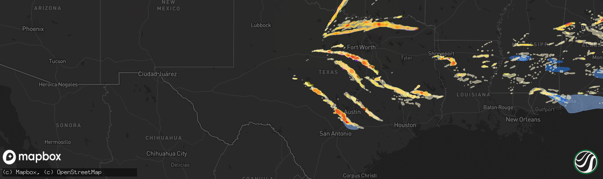
Hail Map in Texas on May 9, 2024
The weather event in Texas on May 9, 2024 includes Wind, Hail, and Tornado maps. 12 states and 1,008 cities were impacted and suffered possible damage. The total estimated number of properties impacted is 263,446.
Want more than just the map?
Turn this storm into a full workflow.
- Owner + property data so you know who to knock
- OnDemand branded weather history reports to win the "did we even have hail?" argument
- RoofTrace estimate so reps stop guessing numbers at the door
Bought this map? Upgrade within 7 days and we'll credit the $230. (10-15 min setup call)
Wind
Hail
Tornado
263,446
Estimated number of impacted properties by a 1.00" hail or larger160,148
Estimated number of impacted properties by a 1.75" hail or larger63,500
Estimated number of impacted properties by a 2.50" hail or largerStorm reports in Texas
Texas
| Date | Description |
|---|---|
| 05/09/20246:55 PM CDT | Photos received of numerous large trees snapped. Minor damage to metal outbuildings. Time estimated from radar. |
| 05/09/20246:50 PM CDT | A local report indicates 1.00 inch wind near 9 NE Enchanted Rock Sta |
| 05/09/20246:38 PM CDT | Report from mping: quarter |
| 05/09/20246:25 PM CDT | Reports of downed trees and power poles between osage and oglesby. Vfds working to clear tree debris from roadways. Reports of a damaged roof and carport in the osage a |
| 05/09/20246:01 PM CDT | Report from mping: quarter |
| 05/09/20246:00 PM CDT | A local report indicates 1.25 inch wind near 3 NE Fredonia |
| 05/09/20245:54 PM CDT | Golfball size hail north of hillsboro. |
| 05/09/20245:48 PM CDT | Golf ball size hail reported in cranfills gap. |
| 05/09/20245:47 PM CDT | Tennis ball size hail between itasca and hillsboro. |
| 05/09/20245:47 PM CDT | Updated hail size to baseball size. Corrects previous hail report from 3 sse itasca. Tennis ball size hail between itasca and hillsboro. |
| 05/09/20245:45 PM CDT | A local report indicates 2.50 inch wind near 5 WSW Voca |
| 05/09/20245:45 PM CDT | Larger than 3 inch hail measured near camp san saba. |
| 05/09/20245:43 PM CDT | Report from mping: softball |
| 05/09/20245:42 PM CDT | Media picture of estimated tennis-ball sized hail in between meridian and cranfills gap in bosque county. |
| 05/09/20245:42 PM CDT | Media picture of 3-3.5 inch hail in the itasca area. |
| 05/09/20245:40 PM CDT | A local report indicates 2.75 inch wind near Voca |
| 05/09/20245:31 PM CDT | Report from mping: quarter |
| 05/09/20245:25 PM CDT | Baseball size hail was reported. |
| 05/09/20245:24 PM CDT | Spotter reported golf ball-sized hail along hwy 75 on the south side of sherman. |
| 05/09/20245:23 PM CDT | Report from mping: hen egg |
| 05/09/20245:21 PM CDT | Report from mping: quarter |
| 05/09/20245:16 PM CDT | Tennis ball size hail was reported. |
| 05/09/20245:15 PM CDT | A local report indicates 2.75 inch wind near 5 SSW Brady |
| 05/09/20245:15 PM CDT | A local report indicates 2.50 inch wind near Brady |
| 05/09/20245:15 PM CDT | Quarter size hail reported at cr1205 and cr1104. |
| 05/09/20245:15 PM CDT | Golf ball hail south side of brady. |
| 05/09/20245:15 PM CDT | Golf ball size hail |
| 05/09/20245:13 PM CDT | Quarter size hail breaking wind shields was reported. |
| 05/09/20245:10 PM CDT | A local report indicates 1.25 inch wind near 1 N Brady |
| 05/09/20245:08 PM CDT | Report from mping: half dollar |
| 05/09/20245:08 PM CDT | 1.25 inch hail reported in hico. |
| 05/09/20245:05 PM CDT | Report of |
| 05/09/20245:05 PM CDT | Report of 3 inch hail at westlake rd and nolan river rd. |
| 05/09/20245:04 PM CDT | A local report indicates 1.00 inch wind near 1 WNW Bogata |
| 05/09/20244:49 PM CDT | 3 inch hail reported at cleburne state park. Corrects previous hail report from 11 sw cleburne. 2 inch hail reported at cleburne state park. |
| 05/09/20244:47 PM CDT | Spotter reports golf-ball sized hail in bonham... Texas at the sheriffs office. |
| 05/09/20244:45 PM CDT | Large tree branch snapped by strong winds in melvin. |
| 05/09/20244:44 PM CDT | Report from mping: quarter |
| 05/09/20244:43 PM CDT | Report from mping: ping pong ball |
| 05/09/20244:40 PM CDT | Golf ball size hail reported in pecan plantation. |
| 05/09/20244:35 PM CDT | Savoy pd reported a mixture of quarter and golf-ball sized hail in the town of savoy... Tx. |
| 05/09/20244:33 PM CDT | A local report indicates 1.25 inch wind near Millersview |
| 05/09/20244:32 PM CDT | Spotter now reports 2-inch hail in northern delta county on fm 128. |
| 05/09/20244:32 PM CDT | Delayed report emergency management reported 4.5 inch hail in pecan plantation. |
| 05/09/20244:30 PM CDT | Emailed photo report. Time estimated. |
| 05/09/20244:30 PM CDT | Lamar county emergency management reported widespread thunderstorm wind damage on the south side of lamar county in between roxton and biardstown. Several houses are da |
| 05/09/20244:30 PM CDT | A local report indicates 1.00 inch wind near Millersview |
| 05/09/20244:30 PM CDT | Ham radio reported wind damage along highway 24 south of paris... Texas. |
| 05/09/20244:30 PM CDT | Emergency management reported damage to large trees and several roofs of homes in the enloe and lake creek area in delta county. |
| 05/09/20244:25 PM CDT | Spotter reported quarter-sized hail in northern delta county on fm 128. |
| 05/09/20244:24 PM CDT | Report from mping: quarter |
| 05/09/20244:23 PM CDT | Report from mping: half dollar |
| 05/09/20244:22 PM CDT | Baseball size hail in tolar. |
| 05/09/20244:21 PM CDT | Emergency management reported golf-ball sized hail in luella... Tx. |
| 05/09/20244:20 PM CDT | Ham radio reported golf-ball sized hail at the fm 1417 and hwy 75 intersection south of sherman... Tx. |
| 05/09/20244:20 PM CDT | Emergency management reported tennis ball-sized hail in luella along cedar rd. |
| 05/09/20244:19 PM CDT | Ping pong ball size hail on sw side of granbury. |
| 05/09/20244:17 PM CDT | Golf ball size hail in granbury. |
| 05/09/20244:13 PM CDT | Spotter report of 2-inch hail west of sherman... Tx near the hwy 289 and hwy 82 intersection. |
| 05/09/20244:12 PM CDT | Report from mping: hen egg |
| 05/09/20244:12 PM CDT | 3.25 inch hail reported in tolar. |
| 05/09/20244:10 PM CDT | Quarter size hail between granbury and lipan on hwy 4. |
| 05/09/20244:10 PM CDT | Emergency management reported trees down in the town of honey grove... Texas. Powerlines are down on the south side of honey grove along hwy 34. It was reported that po |
| 05/09/20244:05 PM CDT | Quarter size hail east of lipan. |
| 05/09/20243:54 PM CDT | Fire dept. Reported quarter-sized hail in downtown whitesboro. |
| 05/09/20243:46 PM CDT | Ham radio reports quarter-sized hail 1 mile east of lake kiowa. |
| 05/09/20243:45 PM CDT | Delayed report half-dollar sized hail reported in woodbine east of gainesville... Texas. |
| 05/09/20243:45 PM CDT | Spotter report of 2-inch hail in northern erath county near the intersection of cr 135 and fm 1188. |
| 05/09/20243:35 PM CDT | Multiple large trees down. Time estimated from radar. |
| 05/09/20243:17 PM CDT | Emergency management reported quarter-sized hail on ponderosa and shepherd rd in howe... Tx. |
| 05/09/20243:14 PM CDT | Report from mping: ping pong ball |
| 05/09/20243:10 PM CDT | Public reported wide range of hail from dime to ping pong ball size. |
| 05/09/20243:10 PM CDT | Emergency management photo of wind damage to a valero gas station at hwy 75 and haning st in howe... Tx. |
| 05/09/20243:00 PM CDT | Emergency management reported downed trees brought down powerlines on college street between 9th and bledsoe st in the town of gunter... Tx. |
| 05/09/20242:39 PM CDT | Amateur radio reports quarter-sized hail in pilot point... Tx. |
| 05/09/20242:36 PM CDT | Delayed report. Public report of tennis-ball sized hail in southeast stephens county. |
| 05/09/20242:15 PM CDT | Emergency management reported tennis-ball sized hail at leona road west of bowie... Tx. |
| 05/09/20242:15 PM CDT | Emergency management reported quarter to half-dollar sized hail falling within the city of bowie... Tx with hail covering the ground just south of the city along highwa |
| 05/09/20242:08 PM CDT | Report from mping: quarter |
| 05/09/20242:08 PM CDT | Report from mping: quarter . |
| 05/09/20241:48 PM CDT | A local report indicates 1.00 inch wind near 4 E Shannon |
| 05/09/20241:20 PM CDT | 1 inch hail reported in alvord. |
| 05/09/20241:16 PM CDT | Report from mping: golf ball |
| 05/09/20241:12 PM CDT | Golfball hail reported at wise co park southwest of chico. |
| 05/09/20241:07 PM CDT | Report from mping: ping pong ball |
| 05/09/202412:25 PM CDT | A local report indicates 2.00 inch wind near Sheppard Afb |
| 05/09/202412:23 PM CDT | Report from mping: half dollar |
| 05/09/202412:17 PM CDT | Hirshci high school. |
| 05/09/202412:16 PM CDT | A local report indicates 1.00 inch wind near Lakeside City |
| 05/09/202412:12 PM CDT | A local report indicates 1.00 inch wind near 2 NNE Lakeside City |
| 05/09/202412:08 PM CDT | Hail reported in jermyn was 2-2.25 inches. |
| 05/09/202412:07 PM CDT | A local report indicates 1.00 inch wind near 3 NW Lakeside City |
| 05/09/202412:06 PM CDT | Report from mping: ping pong ball |
| 05/09/202411:57 AM CDT | 1.75 hail in loving. |
| 05/09/202411:12 AM CDT | Golfball hail reported 10 nw of newcastle. |
| 05/09/202410:10 AM CDT | A local report indicates 1.00 inch wind near 2 SSE Potosi |
| 05/09/20248:15 AM CDT | Numerous trees and fences down in the normangee area. |
| 05/08/20249:44 PM CDT | A local report indicates 1.00 inch wind near Lexington |
| 05/08/20249:32 PM CDT | A local report indicates 2.00 inch wind near 4 SW Rockland |
| 05/08/20249:25 PM CDT | Ham radio operator reported golf ball sized hail along fm 350 n east of leggett. |
| 05/08/20249:23 PM CDT | Report of quarter size hail from tyler county em. |
| 05/08/20249:16 PM CDT | Tree damage picture from social media. |
| 05/08/20249:15 PM CDT | Thunderstorm wind gusts downed a large tree along e pegoda rd in trinity... Damaging power lines. |
| 05/08/20249:15 PM CDT | Thunderstorm wind gusts downed a large tree along e peg |
| 05/08/20249:14 PM CDT | A trained spotter reported quarter sized hail in trinity... As well as power outages. |
| 05/08/20249:11 PM CDT | Golf ball sized hail reported by taylor tx emergency manager. |
| 05/08/20249:09 PM CDT | Hays county emergency manager reports multiple instances of downed powerlines and trees blown down onto roadways from wimberley to san marcos. |
| 05/08/20249:02 PM CDT | Public report of half-dollar to golf ball size hail relayed by broadcast media. |
| 05/08/20249:00 PM CDT | Roof of metal outbuilding was blown off by thunderstorm winds. |
| 05/08/20248:58 PM CDT | Jones ranch twdb mesonet. |
| 05/08/20248:58 PM CDT | Corrects previous tstm wnd dmg report from 3 wnw belmont. Jones ranch twdb mesonet. |
| 05/08/20248:56 PM CDT | Pubilc picture of hail over two inches. |
| 05/08/20248:55 PM CDT | A local report indicates 1.00 inch wind near 4 S Lufkin |
| 05/08/20248:55 PM CDT | Kseq awos 53 kt. |
| 05/08/20248:48 PM CDT | Uprr knbrye station. |
| 05/08/20248:46 PM CDT | Report from mping. |
| 05/08/20248:44 PM CDT | Tree and minor structural damage between prairie lea and kingsbury on county road 232 from pictures on social media; time estimated via radar. |
| 05/08/20248:44 PM CDT | Kbaz asos g53kt. |
| 05/08/20248:43 PM CDT | Baker ranch twdb mesonet. |
| 05/08/20248:43 PM CDT | Ares net reported hail up to half dollar size in the sun city area. |
| 05/08/20248:42 PM CDT | A local report indicates 1.00 inch wind near Georgetown |
| 05/08/20248:40 PM CDT | Scattered tree and power pole/line damage all around the guadalupe and caldwell county line; including the towns of martindale and staples. Time estimated via radar. |
| 05/08/20248:38 PM CDT | Report from mping hen egg |
| 05/08/20248:36 PM CDT | Several home windows broken and solar panel destroyed by wind-blown hail at home of retired law enforcement officer. Max hail size 2 inches. Report relayed by meteorolo |
| 05/08/20248:35 PM CDT | Corrects previous tstm wnd dmg report from 2 nw san marcos. Tree damage... Including a chinese elm laying on the roof of a building. |
| 05/08/20248:34 PM CDT | 3-inch tree limbs broken; power poles broken; from mping. |
| 05/08/20248:34 PM CDT | Corrects previous hail report from burke. Public report of half-dollar to golf ball size hail relayed by broadcast media. |
| 05/08/20248:32 PM CDT | 3-inch tree limbs broken; power poles broken from mping. |
| 05/08/20248:30 PM CDT | A local report indicates 1.25 inch wind near 3 WSW San Marcos |
| 05/08/20248:29 PM CDT | 2.5 inch hail observed near the outlets in san marcos. |
| 05/08/20248:28 PM CDT | Roof damage at hospital. |
| 05/08/20248:27 PM CDT | Multiple trees down and damaged. |
| 05/08/20248:27 PM CDT | San marcos academy. |
| 05/08/20248:25 PM CDT | Half dollar hail in kosse. |
| 05/08/20248:25 PM CDT | Downed trees. |
| 05/08/20248:25 PM CDT | Delayed report and radar estimated time. |
| 05/08/20248:24 PM CDT | 65 mph wind gust recorded by a private weather station in san marcos. |
| 05/08/20248:19 PM CDT | Emergency manager reported tree blown over... Blocking road one quarter mile from fm2325. |
| 05/08/20248:15 PM CDT | Mping report. |
| 05/08/20248:15 PM CDT | A local report indicates 2.00 inch wind near 2 WNW Woodcreek |
| 05/08/20248:14 PM CDT | A local report indicates 2.50 inch wind near 3 ENE Wimberley |
| 05/08/20248:13 PM CDT | Quarter hail 5 miles west of centerville. |
| 05/08/20248:10 PM CDT | Quarter hail in far southern bell county. |
| 05/08/20248:07 PM CDT | A local report indicates 2.50 inch wind near 1 WNW Woodcreek |
| 05/08/20248:05 PM CDT | Local broadcast media reported golf ball to hen egg sized hail in corrigan. |
| 05/08/20248:04 PM CDT | A local report indicates 3.00 inch wind near 4 NNW Woodcreek |
| 05/08/20247:50 PM CDT | Meteorologist storm chaser measured 5 inch hail stone in johnson city approximately 750 pm. |
| 05/08/20247:45 PM CDT | Multiple trees down on hwys 7 and 79 and 39 in the vicinity of jewett marquez and normangee. Time estimated from radar. |
| 05/08/20247:44 PM CDT | A local report indicates 2.75 inch wind near 2 SSW Henly |
| 05/08/20247:40 PM CDT | Meteorologist storm chaser observed softball sized hail. |
| 05/08/20247:28 PM CDT | Golf ball sized hail in johnson city. |
| 05/08/20247:23 PM CDT | A local report indicates 1.50 inch wind near 2 N Johnson City |
| 05/08/20247:23 PM CDT | A local report indicates 1.75 inch wind near 3 SSE Johnson City |
| 05/08/20247:21 PM CDT | Corrects previous hail report from johnson city. Social media photo shows measured 6.25 inch hail in johnson city... Tx. Time is radar estimated. |
| 05/08/20247:21 PM CDT | A local report indicates 1.25 inch wind near 2 N Johnson City |
| 05/08/20247:21 PM CDT | Social media photo shows measured 6.25 inch hail in johnson city... Tx. Time is radar estimated. |
| 05/08/20247:08 PM CDT | Groesbeck fd reported pea to golf-ball sized hail on fm 2489 near groesbeck... Tx. |
| 05/08/20247:05 PM CDT | Multiple downed trees and power outages. Time estimated from radar. |
| 05/08/20247:00 PM CDT | Groesbeck fd reported trees down along cr 633 north of thornton... Tx. |
All States Impacted by Hail Map on May 9, 2024
Cities Impacted by Hail Map on May 9, 2024
- Cassatt, SC
- Hartsville, SC
- Bethune, SC
- Lamar, SC
- Bishopville, SC
- Darlington, SC
- Timmonsville, SC
- Florence, SC
- Effingham, SC
- Hartwell, GA
- Titus, AL
- Wadley, AL
- Royston, GA
- Canon, GA
- Bowersville, GA
- Wetumpka, AL
- Equality, AL
- Elberton, GA
- Roanoke, AL
- Crane Hill, AL
- Eclectic, AL
- Bowman, GA
- Dewy Rose, GA
- Addison, AL
- Arley, AL
- Cullman, AL
- Logan, AL
- Alexander City, AL
- Iva, SC
- Calhoun Falls, SC
- Cleveland, AL
- Hayden, AL
- Dadeville, AL
- Hanceville, AL
- Locust Fork, AL
- Bremen, AL
- Empire, AL
- Camp Hill, AL
- Auburn, AL
- Salem, AL
- Opelika, AL
- Greenville, GA
- Gay, GA
- Smiths Station, AL
- Fortson, GA
- Columbus, GA
- Midland, GA
- Valley, AL
- Upatoi, GA
- Box Springs, GA
- Cataula, GA
- West Point, GA
- Jacksons Gap, AL
- Butler, GA
- Reynolds, GA
- Junction City, GA
- Mauk, GA
- Hamilton, GA
- Fort Valley, GA
- Throckmorton, TX
- Woodson, TX
- Newcastle, TX
- Olney, TX
- Kathleen, GA
- Dry Branch, GA
- Perry, GA
- Bonaire, GA
- Holliday, TX
- Graham, TX
- Hawkinsville, GA
- Bamberg, SC
- Branchville, SC
- Loving, TX
- Buena Vista, GA
- Cochran, GA
- Jermyn, TX
- Chester, GA
- Reevesville, SC
- Walterboro, SC
- Smoaks, SC
- Ellaville, GA
- Wichita Falls, TX
- Bryson, TX
- Jacksboro, TX
- Sheppard Afb, TX
- Rentz, GA
- Cadwell, GA
- Round O, SC
- Eastman, GA
- Saint George, SC
- Dexter, GA
- Andersonville, GA
- Dublin, GA
- Glenwood, GA
- Vienna, GA
- Byromville, GA
- Dorchester, SC
- Cottageville, SC
- Randlett, OK
- Temple, OK
- Union Springs, AL
- Pinehurst, GA
- Tuscola, TX
- Abilene, TX
- Soperton, GA
- Mount Vernon, GA
- Alamo, GA
- Henrietta, TX
- Bowie, TX
- Chico, TX
- Uvalda, GA
- Vidalia, GA
- Lyons, GA
- Ailey, GA
- Albany, TX
- Pitts, GA
- Cordele, GA
- Tarrytown, GA
- Windthorst, TX
- Byers, TX
- Petrolia, TX
- Sylvania, GA
- Walters, OK
- Comanche, OK
- Alvord, TX
- Sunset, TX
- Goose Creek, SC
- Moncks Corner, SC
- Pittsview, AL
- Eufaula, AL
- Mill Creek, OK
- Lumpkin, GA
- Waurika, OK
- Rochelle, GA
- Midway, AL
- Duncan, OK
- Marlow, OK
- Reidsville, GA
- Glennville, GA
- Decatur, TX
- Caddo, TX
- Moran, TX
- Baxley, GA
- Bellevue, TX
- Roff, OK
- Stonewall, OK
- Ringgold, TX
- Clayton, AL
- Rush Springs, OK
- Lindsay, OK
- Bradley, OK
- Tupelo, OK
- Nocona, TX
- Surrency, GA
- Odum, GA
- Strawn, TX
- Sanger, TX
- Breckenridge, TX
- Saint Jo, TX
- Graford, TX
- Valley View, TX
- Era, TX
- Gainesville, TX
- Ludowici, GA
- Cisco, TX
- Montague, TX
- Palo Pinto, TX
- Ranger, TX
- Blanchard, OK
- Purcell, OK
- Washington, OK
- Georgetown, GA
- Morris, GA
- Mershon, GA
- Alma, GA
- Cuthbert, GA
- Whitesboro, TX
- Calvin, OK
- Norman, OK
- Tioga, TX
- Pilot Point, TX
- Noble, OK
- Patterson, GA
- Richland, GA
- Sadler, TX
- Gordonville, TX
- Bristol, GA
- San Angelo, TX
- Forestburg, TX
- Screven, GA
- Mineral Wells, TX
- Collinsville, TX
- Gunter, TX
- Howe, TX
- Muenster, TX
- Jesup, GA
- Shellman, GA
- Dawson, GA
- Scotland, TX
- Hortense, GA
- Eastland, TX
- Sherman, TX
- Lindsay, TX
- Miles, TX
- Mingus, TX
- Brunswick, GA
- Gordon, TX
- Kinta, OK
- Carbon, TX
- Bells, TX
- Whitewright, TX
- Van Alstyne, TX
- Tom Bean, TX
- Santo, TX
- Lipan, TX
- Stephenville, TX
- Bluff Dale, TX
- Bonham, TX
- Saint Simons Island, GA
- Gorman, TX
- Ravenna, TX
- Savoy, TX
- Rosston, TX
- Denison, TX
- Millsap, TX
- Tolar, TX
- De Leon, TX
- Pottsboro, TX
- Telephone, TX
- Windom, TX
- Ivanhoe, TX
- Dodd City, TX
- Bennington, OK
- Ladonia, TX
- Desdemona, TX
- Granbury, TX
- Honey Grove, TX
- Roxton, TX
- Petty, TX
- Sumner, TX
- Arthur City, TX
- Millersview, TX
- Eden, TX
- Dublin, TX
- Boswell, OK
- Powderly, TX
- Thackerville, OK
- Grant, OK
- Brookston, TX
- Cooper, TX
- Ben Franklin, TX
- Pecan Gap, TX
- Cleburne, TX
- Colbert, OK
- Rockford, AL
- Kellyton, AL
- Albany, GA
- Tallassee, AL
- Sylvester, GA
- Ector, TX
- Paris, TX
- Godley, TX
- Nemo, TX
- Melvin, TX
- Enloe, TX
- Lake Creek, TX
- Hendrix, OK
- Hico, TX
- Pattonville, TX
- Bessemer, AL
- Jasper, FL
- Doerun, GA
- Poulan, GA
- Deport, TX
- Bogata, TX
- Iredell, TX
- Lohn, TX
- Paint Rock, TX
- Birmingham, AL
- Helena, AL
- Bokchito, OK
- Rainbow, TX
- Brady, TX
- Rio Vista, TX
- Talco, TX
- Mount Pleasant, TX
- Covington, TX
- Grandview, TX
- Blum, TX
- Pelham, AL
- Walnut Springs, TX
- Glen Rose, TX
- Clarksville, TX
- Annona, TX
- Cranfills Gap, TX
- Meridian, TX
- Itasca, TX
- Hillsboro, TX
- Avery, TX
- Alabaster, AL
- Columbiana, AL
- Chelsea, AL
- Cameron, WV
- Milford, TX
- De Kalb, TX
- Clifton, TX
- Kopperl, TX
- Morgan, TX
- Voca, TX
- Fredonia, TX
- San Saba, TX
- Calera, AL
- Hamilton, TX
- Jonesboro, TX
- Pontotoc, TX
- Mason, TX
- Valley Spring, TX
- Gatesville, TX
- Valley Mills, TX
- Sterrett, AL
- Columbus, MS
- Vandiver, AL
- Waco, TX
- Mertens, TX
- Bynum, TX
- Frost, TX
- Crawford, TX
- Artesia, MS
- Yazoo City, MS
- Shelby, AL
- Malone, TX
- Castell, TX
- Llano, TX
- Oglesby, TX
- Preston, MS
- Mart, TX
- Riesel, TX
- Berry, AL
- Groesbeck, TX
- Philadelphia, MS
- Art, TX
- De Kalb, MS
- Steens, MS
- Ethelsville, AL
- Benton, MS
- Morgantown, WV
- Vincent, AL
- Maidsville, WV
- Osage, WV
- McGregor, TX
- Dawson, TX
- Hubbard, TX
- Millport, AL
- Oakman, AL
- Oakwood, TX
- Fairfield, TX
- Fayette, AL
- Amesville, OH
- Glouster, OH
- Granville, WV
- Scooba, MS
- Sylacauga, AL
- Mexia, TX
- Woodway, TX
- Axtell, TX
- Marietta, OK
- Fredericksburg, TX
- Willow City, TX
- Pell City, AL
- Millfield, OH
- Jacksonville, OH
- Trimble, OH
- Coolidge, TX
- Wortham, TX
- Carrollton, AL
- Emelle, AL
- Aliceville, AL
- Round Mountain, TX
- Eutaw, AL
- Chesterhill, OH
- Moody, TX
- Lorena, TX
- Vaughan, MS
- Kennedy, AL
- Gordo, AL
- Northport, AL
- Starkville, MS
- Marlin, TX
- Parrish, AL
- Johnson City, TX
- Reform, AL
- Pickens, MS
- Thornton, TX
- Adger, AL
- Troy, TX
- Eddy, TX
- Kosse, TX
- Fairfield, AL
- Coker, AL
- Lexington, MS
- Wilsonville, AL
- Dripping Springs, TX
- Blanco, TX
- Camden, MS
- Quinton, AL
- Knoxville, AL
- Ralph, AL
- Lott, TX
- Coushatta, LA
- Weogufka, AL
- Frierson, LA
- Keithville, LA
- Stonewall, LA
- Tuscaloosa, AL
- Groveton, TX
- West Monroe, LA
- Buhl, AL
- Franklin, TX
- Goodman, MS
- Kosciusko, MS
- Shreveport, LA
- Bethany, LA
- De Berry, TX
- Waskom, TX
- Greenwood, LA
- Monroe, LA
- Jewett, TX
- Lampasas, TX
- Ashland, LA
- Bremond, TX
- Macon, MS
- Brookwood, AL
- Corrigan, TX
- Brooksville, MS
- Eros, LA
- Masontown, WV
- Rosebud, TX
- Temple, TX
- Wimberley, TX
- Bankston, AL
- Carthage, MS
- Marquez, TX
- Kempner, TX
- Rayville, LA
- Hye, TX
- Adamsville, AL
- Mulga, AL
- Moscow, TX
- Driftwood, TX
- Moundville, AL
- Dolomite, AL
- Huntsville, TX
- Trinity, TX
- Durant, MS
- Elm Grove, LA
- Fosters, AL
- Briggs, TX
- Docena, AL
- Buda, TX
- Normangee, TX
- Centerville, TX
- San Marcos, TX
- Kyle, TX
- Ringgold, LA
- Bertram, TX
- Burlington, TX
- Burnet, TX
- West, MS
- McCalla, AL
- Harpersville, AL
- Graysville, AL
- Mount Olive, AL
- Fultondale, AL
- Tucumcari, NM
- Delhi, LA
- Killeen, TX
- Cottondale, AL
- Saline, LA
- Apple Springs, TX
- Canyon Lake, TX
- New Braunfels, TX
- Bossier City, LA
- Florence, TX
- Jarrell, TX
- Georgetown, TX
- Leona, TX
- Midway, TX
- Crockett, TX
- Jamestown, LA
- Seguin, TX
- Elrod, AL
- Echola, AL
- Clanton, AL
- Childersburg, AL
- Castor, LA
- Brent, AL
- Gardendale, AL
- Trussville, AL
- Oakhurst, TX
- Trafford, AL
- Pinson, AL
- Morris, AL
- Warrior, AL
- Kimberly, AL
- Diboll, TX
- Duncanville, AL
- Fischer, TX
- Spring Branch, TX
- Brookside, AL
- Chester, TX
- Onalaska, TX
- Kingsbury, TX
- Maxwell, TX
- Martindale, TX
- Lufkin, TX
- Luling, TX
- Lockhart, TX
- Wallis, TX
- Schulenburg, TX
- Weimar, TX
- La Grange, TX
- East Bernard, TX
- Richmond, TX
- Red Rock, TX
- Manvel, TX
- Sugar Land, TX
- Muldoon, TX
- Eagle Lake, TX
- Dale, TX
- Rosanky, TX
- Fresno, TX
- Glidden, TX
- Waelder, TX
- Smithville, TX
- Columbus, TX
- Cat Spring, TX
- Sealy, TX
- Rosenberg, TX
- Harwood, TX
- Alleyton, TX
- Missouri City, TX
- Rosharon, TX
- Flatonia, TX
- Bartlett, TX
- Granger, TX
- Centreville, AL
- Tishomingo, OK
- Mangham, LA
- Winnsboro, LA
- Durant, OK
- Dora, AL
- Odenville, AL
- Remlap, AL
- Oneonta, AL
- Springville, AL
- Lovelady, TX
- Lawley, AL
- Moody, AL
- Ryan, OK
- Hall Summit, LA
- Taylor, TX
- Grady, NM
- Ashville, AL
- Randolph, AL
- Maplesville, AL
- Bedias, TX
- Baskin, LA
- Livingston, TX
- Madisonville, TX
- Oak Ridge, LA
- Vaiden, MS
- Mansfield, LA
- Collinston, LA
- Hutto, TX
- Gonzales, TX
- Cropwell, AL
- Altoona, AL
- Campti, LA
- Fitzpatrick, AL
- Bastrop, LA
- Newellton, LA
- Ragland, AL
- Natchitoches, LA
- Epps, LA
- Pioneer, LA
- Coupland, TX
- Elgin, TX
- Thrall, TX
- Zavalla, TX
- Lexington, TX
- Goldonna, LA
- Robeline, LA
- Natchez, LA
- Steele, AL
- Deatsville, AL
- Bonita, LA
- Tallulah, LA
- Hardaway, AL
- Marbury, AL
- Redwood, MS
- Colmesneil, TX
- Pointblank, TX
- Crawford, MS
- Vicksburg, MS
- Columbia, LA
- McDade, TX
- Montgomery, LA
- Fort Necessity, LA
- Paige, TX
- Lincoln, TX
- Woodstock, AL
- West Blocton, AL
- Raymond, MS
- Edwards, MS
- Coldspring, TX
- Montgomery, AL
- New Waverly, TX
- Utica, MS
- Satartia, MS
- Hurtsboro, AL
- Tuskegee, AL
- Prattville, AL
- Giddings, TX
- Woodville, TX
- Atlanta, LA
- Eudora, AR
- Tuskegee Institute, AL
- Cloutierville, LA
- Melrose, LA
- Bolton, MS
- Shorter, AL
- Pike Road, AL
- Jones, LA
- Clinton, MS
- Oak Grove, LA
- Goodrich, TX
- Notasulga, AL
- Wisner, LA
- Gilbert, LA
- Jasper, TX
- Colfax, LA
- Ledbetter, TX
- Cecil, AL
- Shepherd, TX
- Phenix City, AL
- Jackson, MS
- Willis, TX
- Flora, MS
- Winnfield, LA
- Hazlehurst, MS
- Crystal Springs, MS
- Port Gibson, MS
- Hermanville, MS
- Fort Davis, AL
- Carmine, TX
- Fayette, MS
- Union Church, MS
- Madison, MS
- Lena, LA
- Waverly, AL
- Pattison, MS
- Canton, MS
- Flowood, MS
- Brandon, MS
- Round Top, TX
- Saint Joseph, LA
- Dry Prong, LA
- Georgetown, LA
- Pollock, LA
- Ridgeland, MS
- Bentley, LA
- Saratoga, TX
- Cleveland, TX
- Vernon, AL
- Lena, MS
- Morton, MS
- Trout, LA
- Jena, LA
- Waverly Hall, GA
- Burton, TX
- Fayetteville, TX
- New Ulm, TX
- Conehatta, MS
- Lake, MS
- Industry, TX
- Kirbyville, TX
- Newton, TX
- Brenham, TX
- Forest, MS
- Pelahatchie, MS
- Boyce, LA
- Elmer, LA
- Deville, LA
- Pineville, LA
- Ball, LA
- Silver City, MS
- Thomaston, AL
- Brookhaven, MS
- Wesson, MS
- Ellerslie, GA
- Alexandria, LA
- Natchez, MS
- Uniontown, AL
- Raleigh, MS
- Mendenhall, MS
- Magee, MS
- Catherine, AL
- Safford, AL
- Burkeville, TX
- Newton, MS
- Lawrence, MS
- Pulaski, MS
- Americus, GA
- Plains, GA
- Bellville, TX
- Decatur, MS
- Jonesville, LA
- Little Rock, MS
- Mize, MS
- Leslie, GA
- Hickory, MS
- Meridian, MS
- Chunky, MS
- Collinsville, MS
- Louin, MS
- Jemison, AL
- Lecompte, LA
- Taylorsville, MS
- Bay Springs, MS
- Marion Junction, AL
- Monterey, LA
- McCall Creek, MS
- Bailey, MS
- Thorsby, AL
- Collins, MS
- Prentiss, MS
- Mount Olive, MS
- Newhebron, MS
- Cobb, GA
- Pachuta, MS
- Enterprise, MS
- Marion, MS
- Orrville, AL
- Laurel, MS
- Lisman, AL
- Ward, AL
- Rose Hill, MS
- Heidelberg, MS
- Selma, AL
- Livingston, AL
- Bogue Chitto, MS
- York, AL
- Quitman, MS
- Paulding, MS
- Vossburg, MS
- Butler, AL
- Shubuta, MS
- Waynesboro, MS
- Tougaloo, MS
- Pearl, MS
- Richland, MS
- Soso, MS
- Blountsville, AL
- Elmore, AL
- Jacksonville, GA
- Rhine, GA
- Sontag, MS
- Monticello, MS
- Smithdale, MS
- Linden, AL
- Jones, AL
- Plantersville, AL
- Stonewall, MS
- Roxie, MS
- Silver Creek, MS
- Stringer, MS
- Camden, AL
- Sardis, AL
- Jayess, MS
- Ruth, MS
- Millbrook, AL
- Verbena, AL
- Minter, AL
- Coosada, AL
- Broxton, GA
- Faunsdale, AL
- Oak Vale, MS
- Foxworth, MS
- Columbia, MS
- Gilbertown, AL
- Melvin, AL
- Silas, AL
- Needham, AL
- Toxey, AL
- Campbell, AL
- Thomasville, AL
- Coffeeville, AL
- Jachin, AL
- Marion, AL
- Carson, MS
- Seminary, MS
- Liberty, MS
- Bassfield, MS
- Jackson, AL
- Kokomo, MS
- Magnolia, MS
- Summit, MS
- Purvis, MS
- Lumberton, MS
- Vidalia, LA
- Poplarville, MS
- Angie, LA
- Kentwood, LA
- Dickinson, AL
- Grove Hill, AL
- Osyka, MS
- Mccomb, MS
- Hattiesburg, MS
- Bay Minette, AL
- McDavid, FL
- Lucedale, MS
- Chunchula, AL
- Leakesville, MS
- Citronelle, AL
- Jay, FL
- Crestview, FL
- Baker, FL
- McLain, MS
- Beaumont, MS
- Axis, AL
- Anderson, SC
- Peterman, AL
- Beatrice, AL
- Vredenburgh, AL
- Brooklyn, MS
- Wiggins, MS
- Brewton, AL
- New Augusta, MS
- Rutledge, AL
- Luverne, AL
- Goshen, AL
- Pine Apple, AL
- Grady, AL
- Ramer, AL
- Mathews, AL
- Troy, AL
- Evergreen, AL
- Georgiana, AL
- McKenzie, AL
- Glenwood, AL
- Daleville, AL
- Chancellor, AL
- Neely, MS
- Perkinston, MS
- Greenville, AL
- Forest Home, AL
- Moss Point, MS
- Wilmer, AL
- Semmes, AL
- Eight Mile, AL
- Mobile, AL
- Newton, AL
- Slocomb, AL
- Hartford, AL
- Kinston, AL
- Saucier, MS
- Opp, AL
- Fort Deposit, AL
- Fort Rucker, AL
- Enterprise, AL
- Elba, AL
- Samson, AL
- Andalusia, AL
- Banks, AL
- Louisville, AL
- Clio, AL
- Vancleave, MS
- Saraland, AL
- Grand Bay, AL
- Daphne, AL
- Theodore, AL
- Irvington, AL
- Midland City, AL
- Honoraville, AL
- Brundidge, AL
- Dothan, AL
- Lapine, AL
- Highland Home, AL
- Loxley, AL
- Stapleton, AL
- Robertsdale, AL
- Fairhope, AL
- Florala, AL
- Headland, AL
- Satsuma, AL
- Creola, AL
- Coden, AL
- Silverhill, AL
- Summerdale, AL
- Foley, AL
- Century, FL
- Newville, AL
- Columbia, AL
- Atmore, AL
- Molino, FL
- Cowarts, AL
- Webb, AL
- Magnolia Springs, AL
- Gulf Shores, AL
- Seminole, AL
- Elberta, AL
- Bon Secour, AL
- Dozier, AL
- Brantley, AL
- Jack, AL
- Ariton, AL
- Clopton, AL
- Skipperville, AL
- Orange Beach, AL
- Cantonment, FL
- Lillian, AL
- Pensacola, FL
- Fort Gaines, GA
- Ashford, AL
- Abbeville, AL
- Milton, FL
- Holt, FL
- Donalsonville, GA
- Colquitt, GA
- Gulf Breeze, FL
- Bagdad, FL
- Eglin Afb, FL
- Navarre, FL
- Jakin, GA
- Gordon, AL
- Blakely, GA
- Weston, GA
- Preston, GA
- Cottonwood, AL
- Pansey, AL
- Wing, AL
- Damascus, GA
- Leary, GA
- Defuniak Springs, FL
- Hurlburt Field, FL
- Fort Walton Beach, FL
- Mary Esther, FL
- Shalimar, FL
- Valparaiso, FL
- Niceville, FL
- Miramar Beach, FL
- Destin, FL
- Freeport, FL
- Santa Rosa Beach, FL
- Vernon, FL
- Panama City Beach, FL
- Inlet Beach, FL
- Ponce De Leon, FL
- Bonifay, FL
- Caryville, FL
- Ebro, FL
- Westville, FL
- Newton, GA
- Elko, GA
- Bainbridge, GA
- Brinson, GA
- Iron City, GA
- Camilla, GA
- Panama City, FL
- Lynn Haven, FL
- Pelham, GA
- Climax, GA
- Whigham, GA
- Cairo, GA
- Alford, FL
- Chipley, FL
- Attapulgus, GA
- Quincy, FL
- Port Saint Joe, FL
- Wewahitchka, FL
- Tallahassee, FL
- Sumner, GA
- Meigs, GA
- Ochlocknee, GA
- Waycross, GA
- Midway, FL
- Thomasville, GA
- Moultrie, GA
- Coolidge, GA
- Havana, FL
- Pavo, GA
- Boston, GA
- Dixie, GA
- Flomaton, AL
- Greenville, FL
- Madison, FL
- Pinetta, FL
- Jennings, FL
- Arlington, GA
- Omaha, GA
- Mullin, TX
- Bridgeport, TX
- Paradise, TX
- Springtown, TX
- Comanche, TX
- Weatherford, TX
- Gustine, TX
- Poolville, TX


