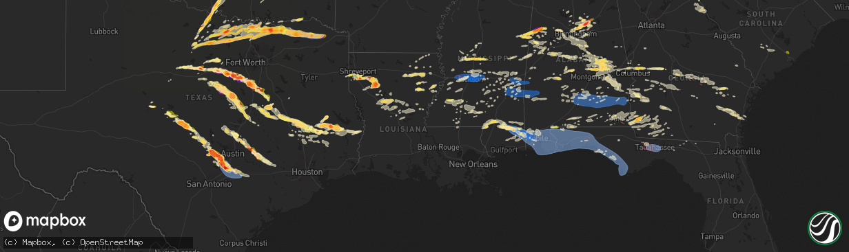
Hail Map in Louisiana on May 9, 2024
The weather event in Louisiana on May 9, 2024 includes Wind, Hail, and Tornado maps. 12 states and 1,008 cities were impacted and suffered possible damage. The total estimated number of properties impacted is 11,612.
Want more than just the map?
Turn this storm into a full workflow.
- Owner + property data so you know who to knock
- OnDemand branded weather history reports to win the "did we even have hail?" argument
- RoofTrace estimate so reps stop guessing numbers at the door
Bought this map? Upgrade within 7 days and we'll credit the $230. (10-15 min setup call)
Wind
Hail
Tornado
11,612
Estimated number of impacted properties by a 1.00" hail or larger2,080
Estimated number of impacted properties by a 1.75" hail or larger1,387
Estimated number of impacted properties by a 2.50" hail or largerStorm reports in Louisiana
Louisiana
| Date | Description |
|---|---|
| 05/08/202410:16 PM CDT | Grant parish sheriff office reports trees down near hwy 71 and hwy 158 intersection. |
| 05/08/202410:00 PM CDT | Grant parish sheriff office reports trees dwon on baudry road off of hwy 1240. |
| 05/08/20249:50 PM CDT | Report from grant parish sheriff office. |
| 05/08/20249:00 PM CDT | Report of a tree downed across hwy-877 just north of hwy-580. |
| 05/08/20248:40 PM CDT | Public photos of golf ball sized hail in hall summit posted to broadcast media social media page. |
| 05/08/20248:40 PM CDT | Report of trees downed on hwy-135 and hwy-15 just south of rayville. |
| 05/08/20248:25 PM CDT | Public report of hailstone estimated at quarter size... Relayed through social media. |
| 05/08/20248:20 PM CDT | Public photo of a measured 3 inch hailstone relayed by broadcast media. |
| 05/08/20248:15 PM CDT | A local report indicates 1.00 inch wind near 6 S Shreveport |
| 05/08/20247:55 PM CDT | Public report of hail up to quarter size along bert kouns industrial loop. |
| 05/08/20247:55 PM CDT | Public reported hail ranging from pea size to less than golf ball size. |
| 05/08/20247:54 PM CDT | Ouachita dispatch reported a tree down south of swartz near highway 139. |
| 05/08/20247:51 PM CDT | A local report indicates 1.00 inch wind near 9 NE Stonewall |
| 05/08/20247:45 PM CDT | A local report indicates 1.75 inch wind near 7 E Stonewall |
| 05/08/20247:45 PM CDT | Public report with pictures of tennis ball size hail in frierson. Relayed by broadcast media. |
All States Impacted by Hail Map on May 9, 2024
Cities Impacted by Hail Map on May 9, 2024
- Cassatt, SC
- Hartsville, SC
- Bethune, SC
- Lamar, SC
- Bishopville, SC
- Darlington, SC
- Timmonsville, SC
- Florence, SC
- Effingham, SC
- Hartwell, GA
- Titus, AL
- Wadley, AL
- Royston, GA
- Canon, GA
- Bowersville, GA
- Wetumpka, AL
- Equality, AL
- Elberton, GA
- Roanoke, AL
- Crane Hill, AL
- Eclectic, AL
- Bowman, GA
- Dewy Rose, GA
- Addison, AL
- Arley, AL
- Cullman, AL
- Logan, AL
- Alexander City, AL
- Iva, SC
- Calhoun Falls, SC
- Cleveland, AL
- Hayden, AL
- Dadeville, AL
- Hanceville, AL
- Locust Fork, AL
- Bremen, AL
- Empire, AL
- Camp Hill, AL
- Auburn, AL
- Salem, AL
- Opelika, AL
- Greenville, GA
- Gay, GA
- Smiths Station, AL
- Fortson, GA
- Columbus, GA
- Midland, GA
- Valley, AL
- Upatoi, GA
- Box Springs, GA
- Cataula, GA
- West Point, GA
- Jacksons Gap, AL
- Butler, GA
- Reynolds, GA
- Junction City, GA
- Mauk, GA
- Hamilton, GA
- Fort Valley, GA
- Throckmorton, TX
- Woodson, TX
- Newcastle, TX
- Olney, TX
- Kathleen, GA
- Dry Branch, GA
- Perry, GA
- Bonaire, GA
- Holliday, TX
- Graham, TX
- Hawkinsville, GA
- Bamberg, SC
- Branchville, SC
- Loving, TX
- Buena Vista, GA
- Cochran, GA
- Jermyn, TX
- Chester, GA
- Reevesville, SC
- Walterboro, SC
- Smoaks, SC
- Ellaville, GA
- Wichita Falls, TX
- Bryson, TX
- Jacksboro, TX
- Sheppard Afb, TX
- Rentz, GA
- Cadwell, GA
- Round O, SC
- Eastman, GA
- Saint George, SC
- Dexter, GA
- Andersonville, GA
- Dublin, GA
- Glenwood, GA
- Vienna, GA
- Byromville, GA
- Dorchester, SC
- Cottageville, SC
- Randlett, OK
- Temple, OK
- Union Springs, AL
- Pinehurst, GA
- Tuscola, TX
- Abilene, TX
- Soperton, GA
- Mount Vernon, GA
- Alamo, GA
- Henrietta, TX
- Bowie, TX
- Chico, TX
- Uvalda, GA
- Vidalia, GA
- Lyons, GA
- Ailey, GA
- Albany, TX
- Pitts, GA
- Cordele, GA
- Tarrytown, GA
- Windthorst, TX
- Byers, TX
- Petrolia, TX
- Sylvania, GA
- Walters, OK
- Comanche, OK
- Alvord, TX
- Sunset, TX
- Goose Creek, SC
- Moncks Corner, SC
- Pittsview, AL
- Eufaula, AL
- Mill Creek, OK
- Lumpkin, GA
- Waurika, OK
- Rochelle, GA
- Midway, AL
- Duncan, OK
- Marlow, OK
- Reidsville, GA
- Glennville, GA
- Decatur, TX
- Caddo, TX
- Moran, TX
- Baxley, GA
- Bellevue, TX
- Roff, OK
- Stonewall, OK
- Ringgold, TX
- Clayton, AL
- Rush Springs, OK
- Lindsay, OK
- Bradley, OK
- Tupelo, OK
- Nocona, TX
- Surrency, GA
- Odum, GA
- Strawn, TX
- Sanger, TX
- Breckenridge, TX
- Saint Jo, TX
- Graford, TX
- Valley View, TX
- Era, TX
- Gainesville, TX
- Ludowici, GA
- Cisco, TX
- Montague, TX
- Palo Pinto, TX
- Ranger, TX
- Blanchard, OK
- Purcell, OK
- Washington, OK
- Georgetown, GA
- Morris, GA
- Mershon, GA
- Alma, GA
- Cuthbert, GA
- Whitesboro, TX
- Calvin, OK
- Norman, OK
- Tioga, TX
- Pilot Point, TX
- Noble, OK
- Patterson, GA
- Richland, GA
- Sadler, TX
- Gordonville, TX
- Bristol, GA
- San Angelo, TX
- Forestburg, TX
- Screven, GA
- Mineral Wells, TX
- Collinsville, TX
- Gunter, TX
- Howe, TX
- Muenster, TX
- Jesup, GA
- Shellman, GA
- Dawson, GA
- Scotland, TX
- Hortense, GA
- Eastland, TX
- Sherman, TX
- Lindsay, TX
- Miles, TX
- Mingus, TX
- Brunswick, GA
- Gordon, TX
- Kinta, OK
- Carbon, TX
- Bells, TX
- Whitewright, TX
- Van Alstyne, TX
- Tom Bean, TX
- Santo, TX
- Lipan, TX
- Stephenville, TX
- Bluff Dale, TX
- Bonham, TX
- Saint Simons Island, GA
- Gorman, TX
- Ravenna, TX
- Savoy, TX
- Rosston, TX
- Denison, TX
- Millsap, TX
- Tolar, TX
- De Leon, TX
- Pottsboro, TX
- Telephone, TX
- Windom, TX
- Ivanhoe, TX
- Dodd City, TX
- Bennington, OK
- Ladonia, TX
- Desdemona, TX
- Granbury, TX
- Honey Grove, TX
- Roxton, TX
- Petty, TX
- Sumner, TX
- Arthur City, TX
- Millersview, TX
- Eden, TX
- Dublin, TX
- Boswell, OK
- Powderly, TX
- Thackerville, OK
- Grant, OK
- Brookston, TX
- Cooper, TX
- Ben Franklin, TX
- Pecan Gap, TX
- Cleburne, TX
- Colbert, OK
- Rockford, AL
- Kellyton, AL
- Albany, GA
- Tallassee, AL
- Sylvester, GA
- Ector, TX
- Paris, TX
- Godley, TX
- Nemo, TX
- Melvin, TX
- Enloe, TX
- Lake Creek, TX
- Hendrix, OK
- Hico, TX
- Pattonville, TX
- Bessemer, AL
- Jasper, FL
- Doerun, GA
- Poulan, GA
- Deport, TX
- Bogata, TX
- Iredell, TX
- Lohn, TX
- Paint Rock, TX
- Birmingham, AL
- Helena, AL
- Bokchito, OK
- Rainbow, TX
- Brady, TX
- Rio Vista, TX
- Talco, TX
- Mount Pleasant, TX
- Covington, TX
- Grandview, TX
- Blum, TX
- Pelham, AL
- Walnut Springs, TX
- Glen Rose, TX
- Clarksville, TX
- Annona, TX
- Cranfills Gap, TX
- Meridian, TX
- Itasca, TX
- Hillsboro, TX
- Avery, TX
- Alabaster, AL
- Columbiana, AL
- Chelsea, AL
- Cameron, WV
- Milford, TX
- De Kalb, TX
- Clifton, TX
- Kopperl, TX
- Morgan, TX
- Voca, TX
- Fredonia, TX
- San Saba, TX
- Calera, AL
- Hamilton, TX
- Jonesboro, TX
- Pontotoc, TX
- Mason, TX
- Valley Spring, TX
- Gatesville, TX
- Valley Mills, TX
- Sterrett, AL
- Columbus, MS
- Vandiver, AL
- Waco, TX
- Mertens, TX
- Bynum, TX
- Frost, TX
- Crawford, TX
- Artesia, MS
- Yazoo City, MS
- Shelby, AL
- Malone, TX
- Castell, TX
- Llano, TX
- Oglesby, TX
- Preston, MS
- Mart, TX
- Riesel, TX
- Berry, AL
- Groesbeck, TX
- Philadelphia, MS
- Art, TX
- De Kalb, MS
- Steens, MS
- Ethelsville, AL
- Benton, MS
- Morgantown, WV
- Vincent, AL
- Maidsville, WV
- Osage, WV
- McGregor, TX
- Dawson, TX
- Hubbard, TX
- Millport, AL
- Oakman, AL
- Oakwood, TX
- Fairfield, TX
- Fayette, AL
- Amesville, OH
- Glouster, OH
- Granville, WV
- Scooba, MS
- Sylacauga, AL
- Mexia, TX
- Woodway, TX
- Axtell, TX
- Marietta, OK
- Fredericksburg, TX
- Willow City, TX
- Pell City, AL
- Millfield, OH
- Jacksonville, OH
- Trimble, OH
- Coolidge, TX
- Wortham, TX
- Carrollton, AL
- Emelle, AL
- Aliceville, AL
- Round Mountain, TX
- Eutaw, AL
- Chesterhill, OH
- Moody, TX
- Lorena, TX
- Vaughan, MS
- Kennedy, AL
- Gordo, AL
- Northport, AL
- Starkville, MS
- Marlin, TX
- Parrish, AL
- Johnson City, TX
- Reform, AL
- Pickens, MS
- Thornton, TX
- Adger, AL
- Troy, TX
- Eddy, TX
- Kosse, TX
- Fairfield, AL
- Coker, AL
- Lexington, MS
- Wilsonville, AL
- Dripping Springs, TX
- Blanco, TX
- Camden, MS
- Quinton, AL
- Knoxville, AL
- Ralph, AL
- Lott, TX
- Coushatta, LA
- Weogufka, AL
- Frierson, LA
- Keithville, LA
- Stonewall, LA
- Tuscaloosa, AL
- Groveton, TX
- West Monroe, LA
- Buhl, AL
- Franklin, TX
- Goodman, MS
- Kosciusko, MS
- Shreveport, LA
- Bethany, LA
- De Berry, TX
- Waskom, TX
- Greenwood, LA
- Monroe, LA
- Jewett, TX
- Lampasas, TX
- Ashland, LA
- Bremond, TX
- Macon, MS
- Brookwood, AL
- Corrigan, TX
- Brooksville, MS
- Eros, LA
- Masontown, WV
- Rosebud, TX
- Temple, TX
- Wimberley, TX
- Bankston, AL
- Carthage, MS
- Marquez, TX
- Kempner, TX
- Rayville, LA
- Hye, TX
- Adamsville, AL
- Mulga, AL
- Moscow, TX
- Driftwood, TX
- Moundville, AL
- Dolomite, AL
- Huntsville, TX
- Trinity, TX
- Durant, MS
- Elm Grove, LA
- Fosters, AL
- Briggs, TX
- Docena, AL
- Buda, TX
- Normangee, TX
- Centerville, TX
- San Marcos, TX
- Kyle, TX
- Ringgold, LA
- Bertram, TX
- Burlington, TX
- Burnet, TX
- West, MS
- McCalla, AL
- Harpersville, AL
- Graysville, AL
- Mount Olive, AL
- Fultondale, AL
- Tucumcari, NM
- Delhi, LA
- Killeen, TX
- Cottondale, AL
- Saline, LA
- Apple Springs, TX
- Canyon Lake, TX
- New Braunfels, TX
- Bossier City, LA
- Florence, TX
- Jarrell, TX
- Georgetown, TX
- Leona, TX
- Midway, TX
- Crockett, TX
- Jamestown, LA
- Seguin, TX
- Elrod, AL
- Echola, AL
- Clanton, AL
- Childersburg, AL
- Castor, LA
- Brent, AL
- Gardendale, AL
- Trussville, AL
- Oakhurst, TX
- Trafford, AL
- Pinson, AL
- Morris, AL
- Warrior, AL
- Kimberly, AL
- Diboll, TX
- Duncanville, AL
- Fischer, TX
- Spring Branch, TX
- Brookside, AL
- Chester, TX
- Onalaska, TX
- Kingsbury, TX
- Maxwell, TX
- Martindale, TX
- Lufkin, TX
- Luling, TX
- Lockhart, TX
- Wallis, TX
- Schulenburg, TX
- Weimar, TX
- La Grange, TX
- East Bernard, TX
- Richmond, TX
- Red Rock, TX
- Manvel, TX
- Sugar Land, TX
- Muldoon, TX
- Eagle Lake, TX
- Dale, TX
- Rosanky, TX
- Fresno, TX
- Glidden, TX
- Waelder, TX
- Smithville, TX
- Columbus, TX
- Cat Spring, TX
- Sealy, TX
- Rosenberg, TX
- Harwood, TX
- Alleyton, TX
- Missouri City, TX
- Rosharon, TX
- Flatonia, TX
- Bartlett, TX
- Granger, TX
- Centreville, AL
- Tishomingo, OK
- Mangham, LA
- Winnsboro, LA
- Durant, OK
- Dora, AL
- Odenville, AL
- Remlap, AL
- Oneonta, AL
- Springville, AL
- Lovelady, TX
- Lawley, AL
- Moody, AL
- Ryan, OK
- Hall Summit, LA
- Taylor, TX
- Grady, NM
- Ashville, AL
- Randolph, AL
- Maplesville, AL
- Bedias, TX
- Baskin, LA
- Livingston, TX
- Madisonville, TX
- Oak Ridge, LA
- Vaiden, MS
- Mansfield, LA
- Collinston, LA
- Hutto, TX
- Gonzales, TX
- Cropwell, AL
- Altoona, AL
- Campti, LA
- Fitzpatrick, AL
- Bastrop, LA
- Newellton, LA
- Ragland, AL
- Natchitoches, LA
- Epps, LA
- Pioneer, LA
- Coupland, TX
- Elgin, TX
- Thrall, TX
- Zavalla, TX
- Lexington, TX
- Goldonna, LA
- Robeline, LA
- Natchez, LA
- Steele, AL
- Deatsville, AL
- Bonita, LA
- Tallulah, LA
- Hardaway, AL
- Marbury, AL
- Redwood, MS
- Colmesneil, TX
- Pointblank, TX
- Crawford, MS
- Vicksburg, MS
- Columbia, LA
- McDade, TX
- Montgomery, LA
- Fort Necessity, LA
- Paige, TX
- Lincoln, TX
- Woodstock, AL
- West Blocton, AL
- Raymond, MS
- Edwards, MS
- Coldspring, TX
- Montgomery, AL
- New Waverly, TX
- Utica, MS
- Satartia, MS
- Hurtsboro, AL
- Tuskegee, AL
- Prattville, AL
- Giddings, TX
- Woodville, TX
- Atlanta, LA
- Eudora, AR
- Tuskegee Institute, AL
- Cloutierville, LA
- Melrose, LA
- Bolton, MS
- Shorter, AL
- Pike Road, AL
- Jones, LA
- Clinton, MS
- Oak Grove, LA
- Goodrich, TX
- Notasulga, AL
- Wisner, LA
- Gilbert, LA
- Jasper, TX
- Colfax, LA
- Ledbetter, TX
- Cecil, AL
- Shepherd, TX
- Phenix City, AL
- Jackson, MS
- Willis, TX
- Flora, MS
- Winnfield, LA
- Hazlehurst, MS
- Crystal Springs, MS
- Port Gibson, MS
- Hermanville, MS
- Fort Davis, AL
- Carmine, TX
- Fayette, MS
- Union Church, MS
- Madison, MS
- Lena, LA
- Waverly, AL
- Pattison, MS
- Canton, MS
- Flowood, MS
- Brandon, MS
- Round Top, TX
- Saint Joseph, LA
- Dry Prong, LA
- Georgetown, LA
- Pollock, LA
- Ridgeland, MS
- Bentley, LA
- Saratoga, TX
- Cleveland, TX
- Vernon, AL
- Lena, MS
- Morton, MS
- Trout, LA
- Jena, LA
- Waverly Hall, GA
- Burton, TX
- Fayetteville, TX
- New Ulm, TX
- Conehatta, MS
- Lake, MS
- Industry, TX
- Kirbyville, TX
- Newton, TX
- Brenham, TX
- Forest, MS
- Pelahatchie, MS
- Boyce, LA
- Elmer, LA
- Deville, LA
- Pineville, LA
- Ball, LA
- Silver City, MS
- Thomaston, AL
- Brookhaven, MS
- Wesson, MS
- Ellerslie, GA
- Alexandria, LA
- Natchez, MS
- Uniontown, AL
- Raleigh, MS
- Mendenhall, MS
- Magee, MS
- Catherine, AL
- Safford, AL
- Burkeville, TX
- Newton, MS
- Lawrence, MS
- Pulaski, MS
- Americus, GA
- Plains, GA
- Bellville, TX
- Decatur, MS
- Jonesville, LA
- Little Rock, MS
- Mize, MS
- Leslie, GA
- Hickory, MS
- Meridian, MS
- Chunky, MS
- Collinsville, MS
- Louin, MS
- Jemison, AL
- Lecompte, LA
- Taylorsville, MS
- Bay Springs, MS
- Marion Junction, AL
- Monterey, LA
- McCall Creek, MS
- Bailey, MS
- Thorsby, AL
- Collins, MS
- Prentiss, MS
- Mount Olive, MS
- Newhebron, MS
- Cobb, GA
- Pachuta, MS
- Enterprise, MS
- Marion, MS
- Orrville, AL
- Laurel, MS
- Lisman, AL
- Ward, AL
- Rose Hill, MS
- Heidelberg, MS
- Selma, AL
- Livingston, AL
- Bogue Chitto, MS
- York, AL
- Quitman, MS
- Paulding, MS
- Vossburg, MS
- Butler, AL
- Shubuta, MS
- Waynesboro, MS
- Tougaloo, MS
- Pearl, MS
- Richland, MS
- Soso, MS
- Blountsville, AL
- Elmore, AL
- Jacksonville, GA
- Rhine, GA
- Sontag, MS
- Monticello, MS
- Smithdale, MS
- Linden, AL
- Jones, AL
- Plantersville, AL
- Stonewall, MS
- Roxie, MS
- Silver Creek, MS
- Stringer, MS
- Camden, AL
- Sardis, AL
- Jayess, MS
- Ruth, MS
- Millbrook, AL
- Verbena, AL
- Minter, AL
- Coosada, AL
- Broxton, GA
- Faunsdale, AL
- Oak Vale, MS
- Foxworth, MS
- Columbia, MS
- Gilbertown, AL
- Melvin, AL
- Silas, AL
- Needham, AL
- Toxey, AL
- Campbell, AL
- Thomasville, AL
- Coffeeville, AL
- Jachin, AL
- Marion, AL
- Carson, MS
- Seminary, MS
- Liberty, MS
- Bassfield, MS
- Jackson, AL
- Kokomo, MS
- Magnolia, MS
- Summit, MS
- Purvis, MS
- Lumberton, MS
- Vidalia, LA
- Poplarville, MS
- Angie, LA
- Kentwood, LA
- Dickinson, AL
- Grove Hill, AL
- Osyka, MS
- Mccomb, MS
- Hattiesburg, MS
- Bay Minette, AL
- McDavid, FL
- Lucedale, MS
- Chunchula, AL
- Leakesville, MS
- Citronelle, AL
- Jay, FL
- Crestview, FL
- Baker, FL
- McLain, MS
- Beaumont, MS
- Axis, AL
- Anderson, SC
- Peterman, AL
- Beatrice, AL
- Vredenburgh, AL
- Brooklyn, MS
- Wiggins, MS
- Brewton, AL
- New Augusta, MS
- Rutledge, AL
- Luverne, AL
- Goshen, AL
- Pine Apple, AL
- Grady, AL
- Ramer, AL
- Mathews, AL
- Troy, AL
- Evergreen, AL
- Georgiana, AL
- McKenzie, AL
- Glenwood, AL
- Daleville, AL
- Chancellor, AL
- Neely, MS
- Perkinston, MS
- Greenville, AL
- Forest Home, AL
- Moss Point, MS
- Wilmer, AL
- Semmes, AL
- Eight Mile, AL
- Mobile, AL
- Newton, AL
- Slocomb, AL
- Hartford, AL
- Kinston, AL
- Saucier, MS
- Opp, AL
- Fort Deposit, AL
- Fort Rucker, AL
- Enterprise, AL
- Elba, AL
- Samson, AL
- Andalusia, AL
- Banks, AL
- Louisville, AL
- Clio, AL
- Vancleave, MS
- Saraland, AL
- Grand Bay, AL
- Daphne, AL
- Theodore, AL
- Irvington, AL
- Midland City, AL
- Honoraville, AL
- Brundidge, AL
- Dothan, AL
- Lapine, AL
- Highland Home, AL
- Loxley, AL
- Stapleton, AL
- Robertsdale, AL
- Fairhope, AL
- Florala, AL
- Headland, AL
- Satsuma, AL
- Creola, AL
- Coden, AL
- Silverhill, AL
- Summerdale, AL
- Foley, AL
- Century, FL
- Newville, AL
- Columbia, AL
- Atmore, AL
- Molino, FL
- Cowarts, AL
- Webb, AL
- Magnolia Springs, AL
- Gulf Shores, AL
- Seminole, AL
- Elberta, AL
- Bon Secour, AL
- Dozier, AL
- Brantley, AL
- Jack, AL
- Ariton, AL
- Clopton, AL
- Skipperville, AL
- Orange Beach, AL
- Cantonment, FL
- Lillian, AL
- Pensacola, FL
- Fort Gaines, GA
- Ashford, AL
- Abbeville, AL
- Milton, FL
- Holt, FL
- Donalsonville, GA
- Colquitt, GA
- Gulf Breeze, FL
- Bagdad, FL
- Eglin Afb, FL
- Navarre, FL
- Jakin, GA
- Gordon, AL
- Blakely, GA
- Weston, GA
- Preston, GA
- Cottonwood, AL
- Pansey, AL
- Wing, AL
- Damascus, GA
- Leary, GA
- Defuniak Springs, FL
- Hurlburt Field, FL
- Fort Walton Beach, FL
- Mary Esther, FL
- Shalimar, FL
- Valparaiso, FL
- Niceville, FL
- Miramar Beach, FL
- Destin, FL
- Freeport, FL
- Santa Rosa Beach, FL
- Vernon, FL
- Panama City Beach, FL
- Inlet Beach, FL
- Ponce De Leon, FL
- Bonifay, FL
- Caryville, FL
- Ebro, FL
- Westville, FL
- Newton, GA
- Elko, GA
- Bainbridge, GA
- Brinson, GA
- Iron City, GA
- Camilla, GA
- Panama City, FL
- Lynn Haven, FL
- Pelham, GA
- Climax, GA
- Whigham, GA
- Cairo, GA
- Alford, FL
- Chipley, FL
- Attapulgus, GA
- Quincy, FL
- Port Saint Joe, FL
- Wewahitchka, FL
- Tallahassee, FL
- Sumner, GA
- Meigs, GA
- Ochlocknee, GA
- Waycross, GA
- Midway, FL
- Thomasville, GA
- Moultrie, GA
- Coolidge, GA
- Havana, FL
- Pavo, GA
- Boston, GA
- Dixie, GA
- Flomaton, AL
- Greenville, FL
- Madison, FL
- Pinetta, FL
- Jennings, FL
- Arlington, GA
- Omaha, GA
- Mullin, TX
- Bridgeport, TX
- Paradise, TX
- Springtown, TX
- Comanche, TX
- Weatherford, TX
- Gustine, TX
- Poolville, TX


