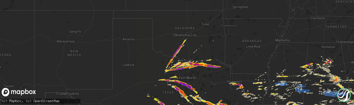
Hail Map on May 9, 2024
The weather event on May 9, 2024 includes Wind, Hail, and Tornado maps. 12 states and 1,008 cities were impacted and suffered possible damage. The total estimated number of properties impacted is 357,305.
Want more than just the map?
Turn this storm into a full workflow.
- Owner + property data so you know who to knock
- OnDemand branded weather history reports to win the "did we even have hail?" argument
- RoofTrace estimate so reps stop guessing numbers at the door
Bought this map? Upgrade within 7 days and we'll credit the $230. (10-15 min setup call)
Wind
Hail
Tornado
357,305
Estimated number of impacted properties by a 1.00" hail or larger198,688
Estimated number of impacted properties by a 1.75" hail or larger71,935
Estimated number of impacted properties by a 2.50" hail or largerStates Impacted by Hail Map on May 9, 2024
Storm reports
Mississippi
| Date | Description |
|---|---|
| 05/09/20246:45 PM CDT | Report of half-dollar-sized hail. |
| 05/09/20246:34 PM CDT | Hail up to the size of quarters fell near preston. |
| 05/09/20246:32 PM CDT | Ping pong ball sized hail in new hope. |
| 05/09/20246:15 PM CDT | Several trees blow |
| 05/09/20246:15 PM CDT | Several trees blown down on 9th street and military road. |
| 05/09/20246:15 PM CDT | Tree blown down on main street in columbus. |
| 05/09/20246:13 PM CDT | Wind gusts of approx. 60mph and hail ranging from pea to half a dollar sized hail. |
| 05/09/20242:38 AM CDT | Minor roof damage and trees down. |
| 05/09/20242:30 AM CDT | Trees and power lines down behind george county middle school. |
| 05/09/20242:30 AM CDT | Damage to rocky creek catfish cottage on old hwy 63. |
| 05/09/20241:59 AM CDT | Trees down on clayton dennis road. |
| 05/09/20241:56 AM CDT | Corrects previous non-tstm wnd dmg report from 1 sse carnes. Tree down in the 500 block on carnes road. |
| 05/09/202412:35 AM CDT | Trees were snapped in the whynot area. Report and picture relayed via social media. |
| 05/09/202412:26 AM CDT | Corrects previous tstm wnd dmg report from snell. Several trees were snapped... And large branches were blown down onto power lines. Pictures and reports relayed via so |
| 05/09/202412:24 AM CDT | A tree was blown down on gene carr road. Report relayed via social media. |
| 05/09/202412:23 AM CDT | A tree was blown down across county road 262. |
| 05/09/202412:23 AM CDT | Trees and powerlines downed on county road 262 in desoto area... Blocking the roadway. |
| 05/09/202412:22 AM CDT | Trees were snapped or uprooted near shubuta... Some of which fell onto power lines. |
| 05/09/202412:17 AM CDT | An oak tree was snapped near the cabins at clarkco state park. Picture and report relayed via social media. |
| 05/09/202412:16 AM CDT | Numerous trees and powerlines down on both county roads 275 and 280. |
| 05/09/202412:16 AM CDT | There was wind damage in the harmony community. |
| 05/09/202412:15 AM CDT | There was significant damage to a house near the zero community. The power meter was ripped off... Cars were damaged... Livestock pens were damaged... And trees were bl |
| 05/09/202412:15 AM CDT | A tree fell onto an 18-wheeler at the interstate 59 exit ramp 137. |
| 05/09/202412:14 AM CDT | Tree downed... With property and home damage on baggett road in the zero community. Time estimated based on radar. |
| 05/09/202412:14 AM CDT | Tree downed along a house on county road 280 in clarke county. Three residents were entrapped at this location. Time estimated based upon radar. |
| 05/09/202412:13 AM CDT | Tree down on river road. Time estimated based on radar. |
| 05/09/202412:13 AM CDT | Tree downed along highway 11 near county road 114. Car collided with tree... No injuries reported. Time estimated based on radar. |
| 05/09/202412:12 AM CDT | A large tree was blown down across the road along county road 350 south of ms highway 514. Report relayed via social media. |
| 05/09/202412:11 AM CDT | Trees were blown down on tm jones road. |
| 05/09/202412:10 AM CDT | Trees were snapped and uprooted along tm jones road. Pictures and reports relayed via social media. |
| 05/09/202412:06 AM CDT | Tree downed on highway 11 near the city of basic. Time estimated based on radar. |
| 05/09/202412:04 AM CDT | Numerous trees and powerlines reported down across the county. Time estimated based on radar. |
| 05/09/202412:01 AM CDT | Report relayed via social media. |
| 05/08/202411:55 PM CDT | Corrects previous hail report from 4 wnw beauregard. Report of quarter-sized hail from social media. |
| 05/08/202411:53 PM CDT | Tree and powerline downed along county road 17 near county road 1721. Time estimated based on radar. |
| 05/08/202411:50 PM CDT | Report of quarter-sized hail from social media. |
| 05/08/202411:40 PM CDT | Trees were blown down on rose road near hickory. Report relayed via social media. |
| 05/08/202411:35 PM CDT | Report of tree downed along highway 80 between hickory and newton. Report via social media. Time estimated based on radar. |
| 05/08/202410:51 PM CDT | Numerous trees were blown down in pelahatchie. |
| 05/08/202410:48 PM CDT | Report from mping of wind damage similar to 1-inch tree limbs broken or shingles blown off. |
| 05/08/202410:48 PM CDT | Several large tree limbs were blown down... And two 1 to 2 foot diameter trees were broken along louis wilson drive. |
| 05/08/202410:46 PM CDT | Social media reported power lines on the street at intersection of east metro parkway and crossgates dr. |
| 05/08/202410:45 PM CDT | Tree blown down in old brandon road. |
| 05/08/202410:45 PM CDT | Tree blown down on house in crossgates neighborhood. |
| 05/08/202410:43 PM CDT | *** 1 inj *** tree fell on a home... Causing an injury to one resident. Time estimated based on radar. |
| 05/08/202410:42 PM CDT | Roof blown off an apartment building at the crosswinds apartment complex. Numerous large tree limbs down throughout the property... With a couple down on vehicles. |
| 05/08/202410:42 PM CDT | Report from mping of wind damage similar to 1-inch tree limbs broken or shingles blown off. |
| 05/08/202410:42 PM CDT | Report from mping of wind damage similar to 1-inch tree limbs broken or shingles blown off. |
| 05/08/202410:42 PM CDT | 60 mph gust |
| 05/08/202410:40 PM CDT | Trees and powerlines downed through the county... With some on structures and cars. Time estimated based on radar. |
| 05/08/202410:40 PM CDT | A report of a large oak tree uprooted that fell onto a house. |
| 05/08/202410:40 PM CDT | Numerous trees down reported in the area of highway 18 near brandon. Time estimated based on radar. |
| 05/08/202410:36 PM CDT | A tree was snapped near a house in the florence area. Report relayed via social media. |
| 05/08/202410:36 PM CDT | Several large trees were uprooted west of the jackson-medgar wiley evers airport. |
| 05/08/202410:33 PM CDT | Numerous 3 to 5 inch tree limbs were blown down onto power lines near wayneland drive. |
| 05/08/202410:30 PM CDT | Damage to homes in the city of pearl. Time estimated based on radar. |
| 05/08/202410:25 PM CDT | A tree was blown down onto power lines near the intersection of west street and taylor street. |
| 05/08/202410:15 PM CDT | Debris was on interstate 20 between bolton and edwards. A tds was noted on radar in the same area. |
| 05/08/20248:15 PM CDT | Report of quarter-sized hail. |
| 05/08/20248:15 PM CDT | Report of quarter-sized hail. |
| 05/08/20247:20 PM CDT | Social media reported ping pong size hail in pickens. |
Texas
| Date | Description |
|---|---|
| 05/09/20246:55 PM CDT | Photos received of numerous large trees snapped. Minor damage to metal outbuildings. Time estimated from radar. |
| 05/09/20246:50 PM CDT | A local report indicates 1.00 inch wind near 9 NE Enchanted Rock Sta |
| 05/09/20246:38 PM CDT | Report from mping: quarter |
| 05/09/20246:25 PM CDT | Reports of downed trees and power poles between osage and oglesby. Vfds working to clear tree debris from roadways. Reports of a damaged roof and carport in the osage a |
| 05/09/20246:01 PM CDT | Report from mping: quarter |
| 05/09/20246:00 PM CDT | A local report indicates 1.25 inch wind near 3 NE Fredonia |
| 05/09/20245:54 PM CDT | Golfball size hail north of hillsboro. |
| 05/09/20245:48 PM CDT | Golf ball size hail reported in cranfills gap. |
| 05/09/20245:47 PM CDT | Tennis ball size hail between itasca and hillsboro. |
| 05/09/20245:47 PM CDT | Updated hail size to baseball size. Corrects previous hail report from 3 sse itasca. Tennis ball size hail between itasca and hillsboro. |
| 05/09/20245:45 PM CDT | Larger than 3 inch hail measured near camp san saba. |
| 05/09/20245:45 PM CDT | A local report indicates 2.50 inch wind near 5 WSW Voca |
| 05/09/20245:43 PM CDT | Report from mping: softball |
| 05/09/20245:42 PM CDT | Media picture of estimated tennis-ball sized hail in between meridian and cranfills gap in bosque county. |
| 05/09/20245:42 PM CDT | Media picture of 3-3.5 inch hail in the itasca area. |
| 05/09/20245:40 PM CDT | A local report indicates 2.75 inch wind near Voca |
| 05/09/20245:31 PM CDT | Report from mping: quarter |
| 05/09/20245:25 PM CDT | Baseball size hail was reported. |
| 05/09/20245:24 PM CDT | Spotter reported golf ball-sized hail along hwy 75 on the south side of sherman. |
| 05/09/20245:23 PM CDT | Report from mping: hen egg |
| 05/09/20245:21 PM CDT | Report from mping: quarter |
| 05/09/20245:16 PM CDT | Tennis ball size hail was reported. |
| 05/09/20245:15 PM CDT | A local report indicates 2.75 inch wind near 5 SSW Brady |
| 05/09/20245:15 PM CDT | A local report indicates 2.50 inch wind near Brady |
| 05/09/20245:15 PM CDT | Golf ball size hail |
| 05/09/20245:15 PM CDT | Golf ball hail south side of brady. |
| 05/09/20245:15 PM CDT | Quarter size hail reported at cr1205 and cr1104. |
| 05/09/20245:13 PM CDT | Quarter size hail breaking wind shields was reported. |
| 05/09/20245:10 PM CDT | A local report indicates 1.25 inch wind near 1 N Brady |
| 05/09/20245:08 PM CDT | 1.25 inch hail reported in hico. |
| 05/09/20245:08 PM CDT | Report from mping: half dollar |
| 05/09/20245:05 PM CDT | Report of |
| 05/09/20245:05 PM CDT | Report of 3 inch hail at westlake rd and nolan river rd. |
| 05/09/20245:04 PM CDT | A local report indicates 1.00 inch wind near 1 WNW Bogata |
| 05/09/20244:49 PM CDT | 3 inch hail reported at cleburne state park. Corrects previous hail report from 11 sw cleburne. 2 inch hail reported at cleburne state park. |
| 05/09/20244:47 PM CDT | Spotter reports golf-ball sized hail in bonham... Texas at the sheriffs office. |
| 05/09/20244:45 PM CDT | Large tree branch snapped by strong winds in melvin. |
| 05/09/20244:44 PM CDT | Report from mping: quarter |
| 05/09/20244:43 PM CDT | Report from mping: ping pong ball |
| 05/09/20244:40 PM CDT | Golf ball size hail reported in pecan plantation. |
| 05/09/20244:35 PM CDT | Savoy pd reported a mixture of quarter and golf-ball sized hail in the town of savoy... Tx. |
| 05/09/20244:33 PM CDT | A local report indicates 1.25 inch wind near Millersview |
| 05/09/20244:32 PM CDT | Delayed report emergency management reported 4.5 inch hail in pecan plantation. |
| 05/09/20244:32 PM CDT | Spotter now reports 2-inch hail in northern delta county on fm 128. |
| 05/09/20244:30 PM CDT | Lamar county emergency management reported widespread thunderstorm wind damage on the south side of lamar county in between roxton and biardstown. Several houses are da |
| 05/09/20244:30 PM CDT | Ham radio reported wind damage along highway 24 south of paris... Texas. |
| 05/09/20244:30 PM CDT | Emergency management reported damage to large trees and several roofs of homes in the enloe and lake creek area in delta county. |
| 05/09/20244:30 PM CDT | Emailed photo report. Time estimated. |
| 05/09/20244:30 PM CDT | A local report indicates 1.00 inch wind near Millersview |
| 05/09/20244:25 PM CDT | Spotter reported quarter-sized hail in northern delta county on fm 128. |
| 05/09/20244:24 PM CDT | Report from mping: quarter |
| 05/09/20244:23 PM CDT | Report from mping: half dollar |
| 05/09/20244:22 PM CDT | Baseball size hail in tolar. |
| 05/09/20244:21 PM CDT | Emergency management reported golf-ball sized hail in luella... Tx. |
| 05/09/20244:20 PM CDT | Emergency management reported tennis ball-sized hail in luella along cedar rd. |
| 05/09/20244:20 PM CDT | Ham radio reported golf-ball sized hail at the fm 1417 and hwy 75 intersection south of sherman... Tx. |
| 05/09/20244:19 PM CDT | Ping pong ball size hail on sw side of granbury. |
| 05/09/20244:17 PM CDT | Golf ball size hail in granbury. |
| 05/09/20244:13 PM CDT | Spotter report of 2-inch hail west of sherman... Tx near the hwy 289 and hwy 82 intersection. |
| 05/09/20244:12 PM CDT | 3.25 inch hail reported in tolar. |
| 05/09/20244:12 PM CDT | Report from mping: hen egg |
| 05/09/20244:10 PM CDT | Quarter size hail between granbury and lipan on hwy 4. |
| 05/09/20244:10 PM CDT | Emergency management reported trees down in the town of honey grove... Texas. Powerlines are down on the south side of honey grove along hwy 34. It was reported that po |
| 05/09/20244:05 PM CDT | Quarter size hail east of lipan. |
| 05/09/20243:54 PM CDT | Fire dept. Reported quarter-sized hail in downtown whitesboro. |
| 05/09/20243:46 PM CDT | Ham radio reports quarter-sized hail 1 mile east of lake kiowa. |
| 05/09/20243:45 PM CDT | Spotter report of 2-inch hail in northern erath county near the intersection of cr 135 and fm 1188. |
| 05/09/20243:45 PM CDT | Delayed report half-dollar sized hail reported in woodbine east of gainesville... Texas. |
| 05/09/20243:35 PM CDT | Multiple large trees down. Time estimated from radar. |
| 05/09/20243:17 PM CDT | Emergency management reported quarter-sized hail on ponderosa and shepherd rd in howe... Tx. |
| 05/09/20243:14 PM CDT | Report from mping: ping pong ball |
| 05/09/20243:10 PM CDT | Public reported wide range of hail from dime to ping pong ball size. |
| 05/09/20243:10 PM CDT | Emergency management photo of wind damage to a valero gas station at hwy 75 and haning st in howe... Tx. |
| 05/09/20243:00 PM CDT | Emergency management reported downed trees brought down powerlines on college street between 9th and bledsoe st in the town of gunter... Tx. |
| 05/09/20242:39 PM CDT | Amateur radio reports quarter-sized hail in pilot point... Tx. |
| 05/09/20242:36 PM CDT | Delayed report. Public report of tennis-ball sized hail in southeast stephens county. |
| 05/09/20242:15 PM CDT | Emergency management reported quarter to half-dollar sized hail falling within the city of bowie... Tx with hail covering the ground just south of the city along highwa |
| 05/09/20242:15 PM CDT | Emergency management reported tennis-ball sized hail at leona road west of bowie... Tx. |
| 05/09/20242:08 PM CDT | Report from mping: quarter . |
| 05/09/20242:08 PM CDT | Report from mping: quarter |
| 05/09/20241:48 PM CDT | A local report indicates 1.00 inch wind near 4 E Shannon |
| 05/09/20241:20 PM CDT | 1 inch hail reported in alvord. |
| 05/09/20241:16 PM CDT | Report from mping: golf ball |
| 05/09/20241:12 PM CDT | Golfball hail reported at wise co park southwest of chico. |
| 05/09/20241:07 PM CDT | Report from mping: ping pong ball |
| 05/09/202412:25 PM CDT | A local report indicates 2.00 inch wind near Sheppard Afb |
| 05/09/202412:23 PM CDT | Report from mping: half dollar |
| 05/09/202412:17 PM CDT | Hirshci high school. |
| 05/09/202412:16 PM CDT | A local report indicates 1.00 inch wind near Lakeside City |
| 05/09/202412:12 PM CDT | A local report indicates 1.00 inch wind near 2 NNE Lakeside City |
| 05/09/202412:08 PM CDT | Hail reported in jermyn was 2-2.25 inches. |
| 05/09/202412:07 PM CDT | A local report indicates 1.00 inch wind near 3 NW Lakeside City |
| 05/09/202412:06 PM CDT | Report from mping: ping pong ball |
| 05/09/202411:57 AM CDT | 1.75 hail in loving. |
| 05/09/202411:12 AM CDT | Golfball hail reported 10 nw of newcastle. |
| 05/09/202410:10 AM CDT | A local report indicates 1.00 inch wind near 2 SSE Potosi |
| 05/09/20248:15 AM CDT | Numerous trees and fences down in the normangee area. |
| 05/08/20249:44 PM CDT | A local report indicates 1.00 inch wind near Lexington |
| 05/08/20249:32 PM CDT | A local report indicates 2.00 inch wind near 4 SW Rockland |
| 05/08/20249:25 PM CDT | Ham radio operator reported golf ball sized hail along fm 350 n east of leggett. |
| 05/08/20249:23 PM CDT | Report of quarter size hail from tyler county em. |
| 05/08/20249:16 PM CDT | Tree damage picture from social media. |
| 05/08/20249:15 PM CDT | Thunderstorm wind gusts downed a large tree along e pegoda rd in trinity... Damaging power lines. |
| 05/08/20249:15 PM CDT | Thunderstorm wind gusts downed a large tree along e peg |
| 05/08/20249:14 PM CDT | A trained spotter reported quarter sized hail in trinity... As well as power outages. |
| 05/08/20249:11 PM CDT | Golf ball sized hail reported by taylor tx emergency manager. |
| 05/08/20249:09 PM CDT | Hays county emergency manager reports multiple instances of downed powerlines and trees blown down onto roadways from wimberley to san marcos. |
| 05/08/20249:02 PM CDT | Public report of half-dollar to golf ball size hail relayed by broadcast media. |
| 05/08/20249:00 PM CDT | Roof of metal outbuilding was blown off by thunderstorm winds. |
| 05/08/20248:58 PM CDT | Corrects previous tstm wnd dmg report from 3 wnw belmont. Jones ranch twdb mesonet. |
| 05/08/20248:58 PM CDT | Jones ranch twdb mesonet. |
| 05/08/20248:56 PM CDT | Pubilc picture of hail over two inches. |
| 05/08/20248:55 PM CDT | Kseq awos 53 kt. |
| 05/08/20248:55 PM CDT | A local report indicates 1.00 inch wind near 4 S Lufkin |
| 05/08/20248:48 PM CDT | Uprr knbrye station. |
| 05/08/20248:46 PM CDT | Report from mping. |
| 05/08/20248:44 PM CDT | Tree and minor structural damage between prairie lea and kingsbury on county road 232 from pictures on social media; time estimated via radar. |
| 05/08/20248:44 PM CDT | Kbaz asos g53kt. |
| 05/08/20248:43 PM CDT | Ares net reported hail up to half dollar size in the sun city area. |
| 05/08/20248:43 PM CDT | Baker ranch twdb mesonet. |
| 05/08/20248:42 PM CDT | A local report indicates 1.00 inch wind near Georgetown |
| 05/08/20248:40 PM CDT | Scattered tree and power pole/line damage all around the guadalupe and caldwell county line; including the towns of martindale and staples. Time estimated via radar. |
| 05/08/20248:38 PM CDT | Report from mping hen egg |
| 05/08/20248:36 PM CDT | Several home windows broken and solar panel destroyed by wind-blown hail at home of retired law enforcement officer. Max hail size 2 inches. Report relayed by meteorolo |
| 05/08/20248:35 PM CDT | Corrects previous tstm wnd dmg report from 2 nw san marcos. Tree damage... Including a chinese elm laying on the roof of a building. |
| 05/08/20248:34 PM CDT | Corrects previous hail report from burke. Public report of half-dollar to golf ball size hail relayed by broadcast media. |
| 05/08/20248:34 PM CDT | 3-inch tree limbs broken; power poles broken; from mping. |
| 05/08/20248:32 PM CDT | 3-inch tree limbs broken; power poles broken from mping. |
| 05/08/20248:30 PM CDT | A local report indicates 1.25 inch wind near 3 WSW San Marcos |
| 05/08/20248:29 PM CDT | 2.5 inch hail observed near the outlets in san marcos. |
| 05/08/20248:28 PM CDT | Roof damage at hospital. |
| 05/08/20248:27 PM CDT | Multiple trees down and damaged. |
| 05/08/20248:27 PM CDT | San marcos academy. |
| 05/08/20248:25 PM CDT | Delayed report and radar estimated time. |
| 05/08/20248:25 PM CDT | Half dollar hail in kosse. |
| 05/08/20248:25 PM CDT | Downed trees. |
| 05/08/20248:24 PM CDT | 65 mph wind gust recorded by a private weather station in san marcos. |
| 05/08/20248:19 PM CDT | Emergency manager reported tree blown over... Blocking road one quarter mile from fm2325. |
| 05/08/20248:15 PM CDT | A local report indicates 2.00 inch wind near 2 WNW Woodcreek |
| 05/08/20248:15 PM CDT | Mping report. |
| 05/08/20248:14 PM CDT | A local report indicates 2.50 inch wind near 3 ENE Wimberley |
| 05/08/20248:13 PM CDT | Quarter hail 5 miles west of centerville. |
| 05/08/20248:10 PM CDT | Quarter hail in far southern bell county. |
| 05/08/20248:07 PM CDT | A local report indicates 2.50 inch wind near 1 WNW Woodcreek |
| 05/08/20248:05 PM CDT | Local broadcast media reported golf ball to hen egg sized hail in corrigan. |
| 05/08/20248:04 PM CDT | A local report indicates 3.00 inch wind near 4 NNW Woodcreek |
| 05/08/20247:50 PM CDT | Meteorologist storm chaser measured 5 inch hail stone in johnson city approximately 750 pm. |
| 05/08/20247:45 PM CDT | Multiple trees down on hwys 7 and 79 and 39 in the vicinity of jewett marquez and normangee. Time estimated from radar. |
| 05/08/20247:44 PM CDT | A local report indicates 2.75 inch wind near 2 SSW Henly |
| 05/08/20247:40 PM CDT | Meteorologist storm chaser observed softball sized hail. |
| 05/08/20247:28 PM CDT | Golf ball sized hail in johnson city. |
| 05/08/20247:23 PM CDT | A local report indicates 1.75 inch wind near 3 SSE Johnson City |
| 05/08/20247:23 PM CDT | A local report indicates 1.50 inch wind near 2 N Johnson City |
| 05/08/20247:21 PM CDT | A local report indicates 1.25 inch wind near 2 N Johnson City |
| 05/08/20247:21 PM CDT | Social media photo shows measured 6.25 inch hail in johnson city... Tx. Time is radar estimated. |
| 05/08/20247:21 PM CDT | Corrects previous hail report from johnson city. Social media photo shows measured 6.25 inch hail in johnson city... Tx. Time is radar estimated. |
| 05/08/20247:08 PM CDT | Groesbeck fd reported pea to golf-ball sized hail on fm 2489 near groesbeck... Tx. |
| 05/08/20247:05 PM CDT | Multiple downed trees and power outages. Time estimated from radar. |
| 05/08/20247:00 PM CDT | Groesbeck fd reported trees down along cr 633 north of thornton... Tx. |
Ohio
| Date | Description |
|---|---|
| 05/09/20246:46 PM CDT | Tree and large limbs down. Wooden fence blown over. |
| 05/09/20246:07 PM CDT | Time estimated based on radar. Trees down on church street and carlisle place in chillicothe. |
Oklahoma
| Date | Description |
|---|---|
| 05/09/20242:58 PM CDT | Report from mping: quarter |
| 05/09/20242:45 PM CDT | Quarter sized hail just west of 12th avenue se and south of east cedar lane. |
| 05/09/20242:37 PM CDT | A local report indicates 1.00 inch wind near 1 SSW Goldsby |
| 05/09/20242:20 PM CDT | A local report indicates 1.00 inch wind near 4 WSW Criner |
| 05/09/20241:55 PM CDT | A local report indicates 1.00 inch wind near 1 NW Lindsay |
| 05/09/20241:37 PM CDT | A local report indicates 1.75 inch wind near Marlow |
| 05/09/20241:31 PM CDT | A local report indicates 1.00 inch wind near 3 WNW Duncan |
| 05/09/20241:00 PM CDT | A local report indicates 1.75 inch wind near Temple |
South Carolina
| Date | Description |
|---|---|
| 05/09/20241:17 PM CDT | Tree down on sc hwy 64 near ravenwood plantation. |
| 05/09/202412:58 PM CDT | Quarter size hail reported at st james ave and fairfax blvd in goose creek. |
| 05/09/202412:17 PM CDT | Dorchester county warning point reported a tree down across eagle drive. |
| 05/09/202411:43 AM CDT | Colleton county dispatch reported a tree down on road at mill pond road and lowcountry highway. |
| 05/09/202411:07 AM CDT | Reported trees down near the intersection of thunder road and ehrhardt road near the town of govan. |
| 05/09/20249:12 AM CDT | Edgefield county dispatch reports a tree down along hwy 430 just outside the city limits. Time estimated based on radar. |
| 05/09/20248:59 AM CDT | Reported a power line down along confederate drive along lake thurmond in the modoc community. |
| 05/09/20248:45 AM CDT | Trees down on utility equipment. |
| 05/09/20248:32 AM CDT | Reported tree down along kennedy road just north of the town of mccormick. |
Alabama
| Date | Description |
|---|---|
| 05/09/20246:40 PM CDT | Social media image. |
| 05/09/20246:38 PM CDT | Social media. |
| 05/09/20246:35 PM CDT | Social media images. |
| 05/09/20245:46 PM CDT | A couple trees down along country road 26 near wildwood chapel. |
| 05/09/202410:11 AM CDT | Numerous trees and a couple power lines down around randolph county... Including in the wedowee and roanoke areas. A vehicle drove into a downed tree along cr 61. Time |
| 05/09/20249:55 AM CDT | Trees down in lineville... Some large. |
| 05/09/20249:28 AM CDT | Several trees and a couple power lines down in the lincoln... Munford... And talladega areas. |
| 05/09/20249:15 AM CDT | Trees down along patton chapel rd near lincoln. Time estimated. |
| 05/09/20249:14 AM CDT | Metal was torn off a storage building at a business and wrapped around power lines. |
| 05/09/20249:07 AM CDT | Trees down in pell city. |
| 05/09/20249:04 AM CDT | Social media report of trees down along i-20 near moody. Time estimated. |
| 05/09/20248:58 AM CDT | Tree on a house on n lake dr and another tree down along roper rd. |
| 05/09/20248:50 AM CDT | A few trees were blown down on ewing gap road. |
| 05/09/20248:49 AM CDT | Trees down along i-59... Chandler mtn rd... And mosley rd in northern st. Clair county. |
| 05/09/20248:47 AM CDT | Tree down along markham dr. |
| 05/09/20248:22 AM CDT | Golf ball size hail was reported by real estate management personnel along lake martin. |
| 05/09/20248:21 AM CDT | A few trees down in the argo area of walker county. |
| 05/09/20248:19 AM CDT | A few trees down in the hayden and smoke rise areas. |
| 05/09/20248:15 AM CDT | A fallen tree near highway 79 and martin rd resulted in a traffic accident. |
| 05/09/20248:15 AM CDT | A fallen tree near highway 79 and martin rd resulted in a traffic accident. |
| 05/09/20248:13 AM CDT | Trees down in loretto. |
| 05/09/20243:55 AM CDT | Tree down along s county road 49. |
| 05/09/20243:53 AM CDT | Numerous trees and power lines down in the eufaula and clayton areas. A tree fell on an apartment building along paul lee parkway... Causing roof/structural damage. |
| 05/09/20243:50 AM CDT | Measured by weatherstem station at foley elementary school. |
| 05/09/20243:46 AM CDT | Quarter size hail reported just south of t.r. Miller high school. |
| 05/09/20243:45 AM CDT | Tree down along highway 52. |
| 05/09/20243:41 AM CDT | Trees reported down in foley. |
| 05/09/20243:40 AM CDT | Tree down on county road 41. |
| 05/09/20243:34 AM CDT | Report of a tree down on county road 33. |
| 05/09/20243:24 AM CDT | Report of a tree down on county rd 72 just outside of ariton. |
| 05/09/20243:20 AM CDT | Power lines down on dyer rd. |
| 05/09/20243:15 AM CDT | Corrects previous non-tstm wnd gst report from 2 w douglasville. Awos station k1r8 1 w douglasville. |
| 05/09/20243:15 AM CDT | Trees and power lines down in bay minette. |
| 05/09/20243:11 AM CDT | Corrects previous non-tstm wnd gst report from brookley field asos. Asos station kbfm mobile brookley. |
| 05/09/20243:07 AM CDT | 54 kt |
| 05/09/20243:06 AM CDT | Trees down in portions of mobile county. |
| 05/09/20243:01 AM CDT | Ham reported a tree fell on a house around the hospital. |
| 05/09/20242:56 AM CDT | Picture on social media. |
| 05/09/20242:51 AM CDT | Numerous trees down in and around the luverne and brantley areas. |
| 05/09/20242:51 AM CDT | Tree fell on a home on old three notch rd causing minor damage. |
| 05/09/20242:25 AM CDT | Numerous reports of trees down in and around georgiana. |
| 05/09/20241:52 AM CDT | Numerous trees down off of county road 56. |
| 05/09/20241:29 AM CDT | Numerous reports of trees down in and around clarke county. |
| 05/09/20241:25 AM CDT | Social media photo of tennis ball size hail on hwy 14 west of tallassee. |
| 05/09/20241:20 AM CDT | Trees reported down in mixonville. |
| 05/09/20241:10 AM CDT | Numerous trees down with power outages around the sweet water area. Us 43 near marengo/clarke county line blocked by trees. |
| 05/09/202412:54 AM CDT | Ping pong ball size hail reported by ema. |
| 05/09/202412:30 AM CDT | Reports of numerous trees and some structural damage in and around choctaw county. |
| 05/08/202411:44 PM CDT | Tree on power lines along county road 15. |
| 05/08/202411:08 PM CDT | Trees down along cheneyhatchee dr and cottonhill rd just west of eufaula. |
| 05/08/202410:59 PM CDT | Tree down on lee road 226/430. |
| 05/08/202410:55 PM CDT | Trees down along highway 51 and cr 43 in the clayton area. |
| 05/08/202410:41 PM CDT | Tree and cable lines down at cunningham dr. |
| 05/08/202410:04 PM CDT | Numerous trees down in tuskegee with damage to power lines. The front entrance of tuskegee university along old montgomery rd was damaged. |
| 05/08/20249:54 PM CDT | A tree reported fallen onto house on bama park rd. |
| 05/08/20249:54 PM CDT | Two dozen trees reported down and blocking roadways across south tallapoosa county... Including cobb rd... Elkins rd... Macedonia rd. |
| 05/08/20249:50 PM CDT | Roof blown off building on sistrunk st... Tallassee. Time estimated from radar. Reported to em at 1230am on 5/10. |
| 05/08/20249:44 PM CDT | A large trees fell onto a storage container near kent. |
| 05/08/20249:34 PM CDT | Several trees down in wetumpka. Some live power lines are also down. |
| 05/08/20249:23 PM CDT | Trees down in deatsville. |
| 05/08/20249:20 PM CDT | 76mph wind gust measured on home weather station along cr 68e. Several lengths of fencing also down at this location. |
| 05/08/20248:59 PM CDT | Social media images of 4-inch hail in holly springs. |
| 05/08/20248:58 PM CDT | Trees down near fayetteville. |
| 05/08/20248:58 PM CDT | Corrects time of previous hail report from holly springs. Photos relayed of very large hail in holly springs area. Hail could be larger than 3 inches in diameter. |
| 05/08/20248:55 PM CDT | Photograph from ema of hail at least 2 inches in diameter. |
| 05/08/20248:53 PM CDT | Social media photo of large hail near pine mountain... At least hen egg size when compared to the adjacent soda can. |
| 05/08/20248:41 PM CDT | Hail up to golf ball size in clay. |
| 05/08/20248:41 PM CDT | Several trees down along hwy 191. |
| 05/08/20248:36 PM CDT | Corrects previous tstm wnd dmg report from 2 sw brent. Trees down in brent along bear creek rd. Time corrected. |
| 05/08/20248:34 PM CDT | Quarter sized hail reported nea |
| 05/08/20248:34 PM CDT | Quarter sized hail reported near pinson on old dixiana rd. |
| 05/08/20248:32 PM CDT | Report of golf ball sized hail relayed by broadcast media. |
| 05/08/20248:30 PM CDT | Report from mping: ping pong ball |
| 05/08/20247:58 PM CDT | Photos relayed of very large hail in holly springs area. Hail could be larger than 3 inches in diameter. |
| 05/08/20247:49 PM CDT | Report of a tree on a house on 41st st and another tree across woodland hills dr. Other reports of numerous trees down around tuscaloosa. |
| 05/08/20247:36 PM CDT | Trees down in brent along bear creek rd. |
| 05/08/20247:20 PM CDT | Social media video of hail at least quarter size falling in belk... With photos of large hail at least hen egg size. |
| 05/08/20247:20 PM CDT | Social media video of hail at least quarter size falling in belk. |
| 05/08/20247:17 PM CDT | Photo relayed of baseball size hail near kennedy. |
| 05/08/20247:15 PM CDT | Corrects previous hail report from millport. Hail was covering the ground with the largest estimated at golf ball size. |
| 05/08/20247:06 PM CDT | Corrects previous hail report from carrollton. Social media. |
Iowa
| Date | Description |
|---|---|
| 05/09/20241:15 PM CDT | [landspout] numerous reports of funnel clouds south of charles city from 1257pm until 125pm. Brief landspout around 115pm per video and law enforcement observations. N |
West Virginia
| Date | Description |
|---|---|
| 05/09/20246:45 PM CDT | Several trees down on centerville rd. |
| 05/09/20246:36 PM CDT | Trees down |
| 05/09/20246:36 PM CDT | Multiple trees down on multiple houses. |
| 05/09/20246:23 PM CDT | Trees down |
| 05/09/20245:57 PM CDT | Several trees down |
| 05/09/20245:50 PM CDT | Trees down |
| 05/08/20249:30 PM CDT | Metal carport roof removed on centerville rd. |
| 05/08/20248:00 PM CDT | Multiple trees down in the full run area |
| 05/08/20247:55 PM CDT | An ef0 tornado causing mostly down trees along with taking part of a roof off a single family residence. |
| 05/08/20247:25 PM CDT | Tree down across deerwalk highway. |
| 05/08/20247:24 PM CDT | Tree and power lines down. |
| 05/08/20247:20 PM CDT | Tree down on montgomery hill road. |
| 05/08/20247:19 PM CDT | *** 1 inj *** ef1 tornado confirmed east of parkersburg... Between state route 31 and state highway 50. Areas of narrow but significant tree damage was noted with trees |
| 05/08/20247:16 PM CDT | Power lines down. |
| 05/08/20247:13 PM CDT | Tree across willowbrook drive. |
| 05/08/20247:01 PM CDT | Tree fell on to house |
Louisiana
| Date | Description |
|---|---|
| 05/08/202410:16 PM CDT | Grant parish sheriff office reports trees down near hwy 71 and hwy 158 intersection. |
| 05/08/202410:00 PM CDT | Grant parish sheriff office reports trees dwon on baudry road off of hwy 1240. |
| 05/08/20249:50 PM CDT | Report from grant parish sheriff office. |
| 05/08/20249:00 PM CDT | Report of a tree downed across hwy-877 just north of hwy-580. |
| 05/08/20248:40 PM CDT | Public photos of golf ball sized hail in hall summit posted to broadcast media social media page. |
| 05/08/20248:40 PM CDT | Report of trees downed on hwy-135 and hwy-15 just south of rayville. |
| 05/08/20248:25 PM CDT | Public report of hailstone estimated at quarter size... Relayed through social media. |
| 05/08/20248:20 PM CDT | Public photo of a measured 3 inch hailstone relayed by broadcast media. |
| 05/08/20248:15 PM CDT | A local report indicates 1.00 inch wind near 6 S Shreveport |
| 05/08/20247:55 PM CDT | Public report of hail up to quarter size along bert kouns industrial loop. |
| 05/08/20247:55 PM CDT | Public reported hail ranging from pea size to less than golf ball size. |
| 05/08/20247:54 PM CDT | Ouachita dispatch reported a tree down south of swartz near highway 139. |
| 05/08/20247:51 PM CDT | A local report indicates 1.00 inch wind near 9 NE Stonewall |
| 05/08/20247:45 PM CDT | Public report with pictures of tennis ball size hail in frierson. Relayed by broadcast media. |
| 05/08/20247:45 PM CDT | A local report indicates 1.75 inch wind near 7 E Stonewall |
Georgia
| Date | Description |
|---|---|
| 05/09/20243:25 PM CDT | Tree down on pine st. |
| 05/09/20243:22 PM CDT | Former law enforcement office and trained spotter reported 50 to 60 mph winds with squall line passage. |
| 05/09/20243:18 PM CDT | Social media photos indicated wind damage to a gas station overhang and downed power lines in sterling... Ga near the intersection of us highway 32 and us highway 341. |
| 05/09/20242:53 PM CDT | Mcintosh county dispatch reported a tree down in the shellman bluff area. |
| 05/09/20242:40 PM CDT | Tree down on jones rd |
| 05/09/20242:40 PM CDT | Chatham county emergency management reports trees down on power lines on the 200 block of wild heron rd. |
| 05/09/20242:40 PM CDT | Tree fell on dump truck near the intersection of truman pkwy and derenne ave. |
| 05/09/20242:35 PM CDT | Along springvale road. |
| 05/09/20242:33 PM CDT | Report of tree down across the road 6300 block of chief of love rd. |
| 05/09/20242:30 PM CDT | Liberty county dispatch reported a tree down at limerick road and 5th street. |
| 05/09/20242:29 PM CDT | Liberty county dispatch reported a tree down at 400 block of dogwood lane. |
| 05/09/20242:24 PM CDT | Liberty county dispatch reported a tree down at gill park. |
| 05/09/20242:14 PM CDT | Long county dispatch reported two trees down in the county. |
| 05/09/20241:58 PM CDT | Trees reported down along jp hall road. Time est from radar. |
| 05/09/20241:56 PM CDT | Reports of numerous power lines and downed trees near bowens mill road and highway 268. A potential funnel cloud or tornado was reported near this area. |
| 05/09/20241:55 PM CDT | Emergency manager reported powerlines and trees down with tin metal sheeting blown around. Widespread around the city.. Time based on radar. |
| 05/09/20241:55 PM CDT | Bulloch county emergency management reported power lines down at lawrence church road and ash branch church road. |
| 05/09/20241:53 PM CDT | Mcintosh county dispatch reported a tree down in the shellman bluff area. |
| 05/09/20241:52 PM CDT | Bulloch county emergency management reported power lines down at highway 46 and hood loop road. |
| 05/09/20241:45 PM CDT | Trees reported down on broxton highway. Time estimated from radar. |
| 05/09/20241:45 PM CDT | Possible thunderstorm wind damage in this location... Fire units were dispatched to investigate. Possible tornado reported. |
| 05/09/20241:39 PM CDT | Tree down at priester rd on ga hwy 119. |
| 05/09/20241:38 PM CDT | Three power poles down in ocilla. |
| 05/09/20241:37 PM CDT | Bulloch county emergency management reported a tree down on gus denmark road. |
| 05/09/20241:35 PM CDT | Trees down on mcleod road. |
| 05/09/20241:34 PM CDT | Evans county dispatch reported a tree down near the intersection of daisy nevils highway and edgar hodges road. |
| 05/09/20241:34 PM CDT | Evans county dispatch reported a tree down near the intersection of hw-280 and george strickland road. |
| 05/09/20241:31 PM CDT | Tattnall county emergency management reported a tree down at 800 block of love rogers road. |
| 05/09/20241:30 PM CDT | Evans county dispatch reported a tree down near the intersection of tom mccall road and jennie station road. |
| 05/09/20241:30 PM CDT | Evans county dispatch reported a 1 tree down near the intersection of hw-280 and recreation dept road. |
| 05/09/20241:30 PM CDT | Tattnall county emergency management reported a tree down on highway 169 in mendes. |
| 05/09/20241:28 PM CDT | Evans county dispatch reported 2 trees down in claxton. One was on n grady street and another was on w james street. |
| 05/09/20241:28 PM CDT | Report from mping: trees uprooted or snapped; roof blown off. |
| 05/09/20241:26 PM CDT | Evans county dispatch reported a tree down near the intersection of hw-129 and cedar creek road. |
| 05/09/20241:20 PM CDT | Lots of downed trees and a few power lines down throughout ben hill county. |
| 05/09/20241:20 PM CDT | Bulloch county emergency management reported a tree down on mobile home at the 12000 block of highway 301 south. |
| 05/09/20241:19 PM CDT | Tattnall county emergency management reported a tree down at henry street in manassas. |
| 05/09/20241:19 PM CDT | Tattnall county 911 center reports several trees down around reidsville. |
| 05/09/20241:18 PM CDT | At least quarter sized hail at tattnall county high school |
| 05/09/20241:17 PM CDT | Tattnall county emergency management reported a tree down at lee tidwell road and gladys holland road. |
| 05/09/20241:15 PM CDT | Tattnall county emergency management reported a tree down at evergreen church road and gary barnard road. |
| 05/09/20241:15 PM CDT | Tree down on hwy 23 in collins... Ga. |
| 05/09/20241:15 PM CDT | Bulloch county emergency management reported a tree down at shelby street and east parrish street. |
| 05/09/20241:14 PM CDT | Long county dispatch reported two trees down in the county. |
| 05/09/20241:12 PM CDT | Tree down on live oak st in collins... Ga. |
| 05/09/20241:07 PM CDT | Tattnall county emergency management reported a tree down at wilbur kennedy road and pinegrove church road. |
| 05/09/20241:06 PM CDT | Tattnall county emergency management reported a tree down at lynntown road and skid rich road. |
| 05/09/20241:06 PM CDT | Tattnall county emergency management reported a tree down at jesse lynn road. |
| 05/09/20241:04 PM CDT | Significant wind damage reported near the walmart on ga-280. Tornado possible. |
| 05/09/202412:50 PM CDT | Bulloch county emergency management reported a tree down at ponderosa road and rock point road. |
| 05/09/202412:50 PM CDT | Ema volunteer reports a large tree uprooted and toppled in the clyde blvd area. Tornado possible. |
| 05/09/202412:48 PM CDT | Wind damage reported in downtown vidalia. Tornado possible. |
| 05/09/202412:30 PM CDT | Trained spotter reported a tornado on the ground near the intersection of ga-19 and camp road. |
| 05/09/202412:29 PM CDT | Screven county dispatch reported a tree down on burtons ferry highway near lawton road. |
| 05/09/202412:25 PM CDT | Em reported tree down at clayhill rd near thairdell rd. |
| 05/09/202412:22 PM CDT | Jenkins county emergency manager reported a tree down on east old savannah road near aaron road. |
| 05/09/202412:15 PM CDT | Two trees down along martin luther king jr dr at campground rd and near holliday rd. |
| 05/09/202412:15 PM CDT | Em reported tree down at airport rd near old airport rd. |
| 05/09/202412:10 PM CDT | Em reported tree down at scotland rd and haywood lowery rd. |
| 05/09/202412:10 PM CDT | Several trees down northeast of rentz between ga 117 and hwy319. Specifically ga117 at the school near mark wood rd and at emily currie rd as well as jj club rd at ga28 |
| 05/09/202412:05 PM CDT | Em reported powerlines down in dexter near pineway dr on taylor rowland rd. |
| 05/09/202412:05 PM CDT | Em reported 2 trees down near chic inn rd at self rd and at ella burch rd and s us hwy 441. |
| 05/09/202412:03 PM CDT | Em reports 15 plus trees and powerlines down across an area stretching from cadwell to rentz between ga 117 and ga518 and from ga 126 and ga525. Specific points also in |
| 05/09/202411:58 AM CDT | Trees and powerlines down across portions of plainfield per photos provided by media. |
| 05/09/202411:57 AM CDT | Wind damage along wilson woodard rd. Possible tornado damage. |
| 05/09/202411:56 AM CDT | Trees down along wilson woodard road. |
| 05/09/202411:55 AM CDT | Report from mping: 3-inch tree limbs broken; power poles broken. |
| 05/09/202411:45 AM CDT | Quarter-size hail at ga-26 and n broad st. |
| 05/09/202411:36 AM CDT | Trees and lines down on town creek church rd north of calendar creek rd. |
| 05/09/202411:36 AM CDT | Trees and lines down on town creek church rd north of calendar creek rd. |
| 05/09/202411:33 AM CDT | Multiple trees that fell on the residence off triple r trail... Damaging the roof... Skylights... Trusses and interior. |
| 05/09/202411:10 AM CDT | Tree downed at smokey rd and hamilton rd. |
| 05/09/20249:31 AM CDT | Em reports a tree down on powerlines on morgan valley rd between 4th st and old cedartown in rockmart. |
| 05/09/20247:45 AM CDT | Tree downed at bunk tillman road and old athens highway. |
| 05/09/20247:40 AM CDT | Power line downed on carriage way off of hwy 81. |
| 05/09/20247:40 AM CDT | Tree downed on cherokee ave. |
| 05/09/20247:30 AM CDT | Tree on powerline on knox bridge rd. Time estimated from radar. |
| 05/09/20247:20 AM CDT | Corrects previous tstm wnd dmg report from 1 nne five points. Em reports tree down at sweetgum ln and sims bridge rd. |
| 05/09/20247:15 AM CDT | Corrects previous tstm wnd dmg report from 1 ne banks crossing. Em reports tree down at dodd rd and harden bridge rd. |
| 05/09/20247:12 AM CDT | Large tree down blocking villa rica hwy near paul aiken rd. |
| 05/09/20247:10 AM CDT | Corrects previous tstm wnd dmg report from 3 ne maysville. Em reports two trees down at hwy 98 near quail rd and grove level rd near n mangum bridge rd. |
| 05/09/20247:08 AM CDT | Tree down on vehicle at hembree rd near northmeadows pkwy... No injuries. |
| 05/09/20247:05 AM CDT | Several trees down near hwy 441 along apple pie ridge rd at hwy 441 bypass and near dalton dr as well as harmony church rd near ferguson rd and hwy 105 near laurel ridg |
| 05/09/20247:05 AM CDT | Several trees and powerlines down in area circled by damascus rd... Ga105... And chitwood rd. |
| 05/09/20247:00 AM CDT | Em reports two trees down near welborn rd near hickory level creek and queen rd between hwy 323 and carson segars rd. |
| 05/09/20247:00 AM CDT | Em reports two trees down near yonah homer rd at wynn lake rd and mt sinai rd near silver shoals rd. |
| 05/09/20246:17 AM CDT | Trees down on 12 mile post road. |
| 05/09/20246:00 AM CDT | Trees down along metcalf road near pebble point drive. |
| 05/09/20245:55 AM CDT | Em reported tree down at river ridge rd near aska rd. |
| 05/09/20245:45 AM CDT | Trees down on egg & butter road. |
| 05/09/20245:45 AM CDT | Trees down on palmer road. |
| 05/09/20245:36 AM CDT | Trees down along highway 3. |
| 05/09/20245:07 AM CDT | Large tree limbs down on highway 65 blocking the road. |
| 05/09/20244:15 AM CDT | Tree limbs down blocking the road on sr 50 before girard street. |
| 05/09/20244:07 AM CDT | Report of 2.5 inch hail west sheffield and highway 27. |
| 05/09/202412:00 AM CDT | Estimated quarter sized hail for about 10 minutes in the benevolence area. |
Missouri
| Date | Description |
|---|---|
| 05/08/20249:01 PM CDT | An ef-1 tornado with peak winds of 93 mph touched down in arcadia... Mo and tracked east for two minutes before lifting west-southwest of roselle... Mo. |
Florida
| Date | Description |
|---|---|
| 05/09/20246:57 AM CDT | Damage to a vehicle from a fallen tree along old logging trail. |
| 05/09/20246:53 AM CDT | Asos station ktlh tallahassee international airport. |
| 05/09/20246:50 AM CDT | Tree down along highway 53 near cherry lake. |
| 05/09/20246:45 AM CDT | Several trees down in perry. |
| 05/09/20246:45 AM CDT | Perry airport gusted to 62 mph. |
| 05/09/20246:40 AM CDT | Callahan loop had multiple trees and power poles down... Twisted tops out of pines and damaged fences. Possible tornado. |
| 05/09/20246:40 AM CDT | Multiple trees down... Trees snapped in half... Lots of limbs... Athletic training materials damaged or destroyed. Possible tornado. |
| 05/09/20246:35 AM CDT | Trees down on alton wentworth road. |
| 05/09/20246:31 AM CDT | Trees down on wyoming ave. |
| 05/09/20246:30 AM CDT | Trees down along sw mt olive church road. |
| 05/09/20246:30 AM CDT | Trees down along s salt road. |
| 05/09/20246:30 AM CDT | Several trees down along sw mt gilead road with damage to a trailer. |
| 05/09/20246:20 AM CDT | Tree down on house on birdwell road. |
| 05/09/20246:20 AM CDT | Trees down in the wacissa area. |
| 05/09/20246:20 AM CDT | Trees down along old buzbee road. |
| 05/09/20246:18 AM CDT | Ambient weather station gusted to 73 mph. |
| 05/09/20246:12 AM CDT | Nws employee reported snapped/downed trees. |
| 05/09/20246:10 AM CDT | Mesonet station 1080w state capital complex |
| 05/09/20246:08 AM CDT | Trees were blown down in the southwood area. |
| 05/09/20246:07 AM CDT | Large tree down on finner road. |
| 05/09/20246:06 AM CDT | Several trees and power lines down. |
| 05/09/20246:05 AM CDT | Roland harvey road had lines and large trees down. |
| 05/09/20246:05 AM CDT | Northeast tallahassee weatherstem gusted to 62 mph. |
| 05/09/20246:02 AM CDT | Famu weatherstem gusted to 84 mph. |
| 05/09/20246:00 AM CDT | Corrects time of previous tstm wnd gst report from tallahassee international a/p. Asos station ktlh tallahassee international airport. |
| 05/09/20245:59 AM CDT | Mesonet station tt671 tallahassee forestry cntr. |
| 05/09/20245:58 AM CDT | Large tree down along jackson bluff road. |
| 05/09/20245:53 AM CDT | Asos station kecp panama city. |
| 05/09/20245:50 AM CDT | A second tornado developed near the gadsden/leon county border and tracked into tallahassee. Preliminary rating ef2. |
| 05/09/20245:50 AM CDT | Gadsden em reports downed trees in the area of the i-10 192 ramp in midway. |
| 05/09/20245:45 AM CDT | Numerous trees and power lines down across liberty county. |
| 05/09/20245:38 AM CDT | A tornado tracked from gadsden county into leon county with preliminary ef1 damage noted in gadsden county and ef2 damage in leon county as it moved through tallahassee |
| 05/09/20245:36 AM CDT | Report from mping: quarter |
| 05/09/20245:28 AM CDT | Ambient station gusted to 63 mph. |
| 05/09/20245:26 AM CDT | Ambient station gusted to 58 mph. |
| 05/09/20245:07 AM CDT | Asos station kecp panama city. |
| 05/09/20244:15 AM CDT | A local report indicates 84 MPH wind near Crestview |
| 05/09/20244:13 AM CDT | Wind damage to an awning that was stripped off the canopy of a gas station. Paneling stripped from the side of a church building. |
| 05/09/20244:05 AM CDT | Multiple large trees uprooted/downed in the community of baker. |
| 05/09/20244:01 AM CDT | A local report indicates 62 MPH wind near Pensacola International |
| 05/09/20243:59 AM CDT | Reported from raws station tt670 at blackwater forestry center. |
| 05/09/20243:53 AM CDT | Gazebo destroyed and numerous trees and powerlines down in the allentown area. |
| 05/09/20243:53 AM CDT | The tornado started along state highway 4 about 3 miles west northwest of munson where pine trees were snapped and power lines were downed in a convergent pattern. The |
| 05/09/20243:49 AM CDT | Reports of trees and powerlines down. |
| 05/09/20243:48 AM CDT | Snapped trees and power lines along highway 4 near and east of the community of berrydale. Significant straight line wind damage with speeds estimated between 90-110 mp |
| 05/09/20243:47 AM CDT | Significant straight line wind damage on state hwy 87 where multiple wooden power poles were snapped. Metal roofing from a small barn was also lifted and blown between |
| 05/09/20243:41 AM CDT | Corrects previous tstm wnd gst report from 1 w jay. |
| 05/09/20243:40 AM CDT | *** 2 inj *** large hardwood trees uprooted or snapped aloft with power lines also down near jay high school. Residential damage also reported on watermill rd with 2 pe |
| 05/09/20242:41 AM CDT | A local report indicates 66 MPH wind near 1 W Jay |
North Carolina
| Date | Description |
|---|---|
| 05/09/202411:13 AM CDT | Trees down on power lines and utility equipment in sylva. |
Cities Impacted by Hail Map on May 9, 2024
- Cassatt, SC
- Hartsville, SC
- Bethune, SC
- Lamar, SC
- Bishopville, SC
- Darlington, SC
- Timmonsville, SC
- Florence, SC
- Effingham, SC
- Hartwell, GA
- Titus, AL
- Wadley, AL
- Royston, GA
- Canon, GA
- Bowersville, GA
- Wetumpka, AL
- Equality, AL
- Elberton, GA
- Roanoke, AL
- Crane Hill, AL
- Eclectic, AL
- Bowman, GA
- Dewy Rose, GA
- Addison, AL
- Arley, AL
- Cullman, AL
- Logan, AL
- Alexander City, AL
- Iva, SC
- Calhoun Falls, SC
- Cleveland, AL
- Hayden, AL
- Dadeville, AL
- Hanceville, AL
- Locust Fork, AL
- Bremen, AL
- Empire, AL
- Camp Hill, AL
- Auburn, AL
- Salem, AL
- Opelika, AL
- Greenville, GA
- Gay, GA
- Smiths Station, AL
- Fortson, GA
- Columbus, GA
- Midland, GA
- Valley, AL
- Upatoi, GA
- Box Springs, GA
- Cataula, GA
- West Point, GA
- Jacksons Gap, AL
- Butler, GA
- Reynolds, GA
- Junction City, GA
- Mauk, GA
- Hamilton, GA
- Fort Valley, GA
- Throckmorton, TX
- Woodson, TX
- Newcastle, TX
- Olney, TX
- Kathleen, GA
- Dry Branch, GA
- Perry, GA
- Bonaire, GA
- Holliday, TX
- Graham, TX
- Hawkinsville, GA
- Bamberg, SC
- Branchville, SC
- Loving, TX
- Buena Vista, GA
- Cochran, GA
- Jermyn, TX
- Chester, GA
- Reevesville, SC
- Walterboro, SC
- Smoaks, SC
- Ellaville, GA
- Wichita Falls, TX
- Bryson, TX
- Jacksboro, TX
- Sheppard Afb, TX
- Rentz, GA
- Cadwell, GA
- Round O, SC
- Eastman, GA
- Saint George, SC
- Dexter, GA
- Andersonville, GA
- Dublin, GA
- Glenwood, GA
- Vienna, GA
- Byromville, GA
- Dorchester, SC
- Cottageville, SC
- Randlett, OK
- Temple, OK
- Union Springs, AL
- Pinehurst, GA
- Tuscola, TX
- Abilene, TX
- Soperton, GA
- Mount Vernon, GA
- Alamo, GA
- Henrietta, TX
- Bowie, TX
- Chico, TX
- Uvalda, GA
- Vidalia, GA
- Lyons, GA
- Ailey, GA
- Albany, TX
- Pitts, GA
- Cordele, GA
- Tarrytown, GA
- Windthorst, TX
- Byers, TX
- Petrolia, TX
- Sylvania, GA
- Walters, OK
- Comanche, OK
- Alvord, TX
- Sunset, TX
- Goose Creek, SC
- Moncks Corner, SC
- Pittsview, AL
- Eufaula, AL
- Mill Creek, OK
- Lumpkin, GA
- Waurika, OK
- Rochelle, GA
- Midway, AL
- Duncan, OK
- Marlow, OK
- Reidsville, GA
- Glennville, GA
- Decatur, TX
- Caddo, TX
- Moran, TX
- Baxley, GA
- Bellevue, TX
- Roff, OK
- Stonewall, OK
- Ringgold, TX
- Clayton, AL
- Rush Springs, OK
- Lindsay, OK
- Bradley, OK
- Tupelo, OK
- Nocona, TX
- Surrency, GA
- Odum, GA
- Strawn, TX
- Sanger, TX
- Breckenridge, TX
- Saint Jo, TX
- Graford, TX
- Valley View, TX
- Era, TX
- Gainesville, TX
- Ludowici, GA
- Cisco, TX
- Montague, TX
- Palo Pinto, TX
- Ranger, TX
- Blanchard, OK
- Purcell, OK
- Washington, OK
- Georgetown, GA
- Morris, GA
- Mershon, GA
- Alma, GA
- Cuthbert, GA
- Whitesboro, TX
- Calvin, OK
- Norman, OK
- Tioga, TX
- Pilot Point, TX
- Noble, OK
- Patterson, GA
- Richland, GA
- Sadler, TX
- Gordonville, TX
- Bristol, GA
- San Angelo, TX
- Forestburg, TX
- Screven, GA
- Mineral Wells, TX
- Collinsville, TX
- Gunter, TX
- Howe, TX
- Muenster, TX
- Jesup, GA
- Shellman, GA
- Dawson, GA
- Scotland, TX
- Hortense, GA
- Eastland, TX
- Sherman, TX
- Lindsay, TX
- Miles, TX
- Mingus, TX
- Brunswick, GA
- Gordon, TX
- Kinta, OK
- Carbon, TX
- Bells, TX
- Whitewright, TX
- Van Alstyne, TX
- Tom Bean, TX
- Santo, TX
- Lipan, TX
- Stephenville, TX
- Bluff Dale, TX
- Bonham, TX
- Saint Simons Island, GA
- Gorman, TX
- Ravenna, TX
- Savoy, TX
- Rosston, TX
- Denison, TX
- Millsap, TX
- Tolar, TX
- De Leon, TX
- Pottsboro, TX
- Telephone, TX
- Windom, TX
- Ivanhoe, TX
- Dodd City, TX
- Bennington, OK
- Ladonia, TX
- Desdemona, TX
- Granbury, TX
- Honey Grove, TX
- Roxton, TX
- Petty, TX
- Sumner, TX
- Arthur City, TX
- Millersview, TX
- Eden, TX
- Dublin, TX
- Boswell, OK
- Powderly, TX
- Thackerville, OK
- Grant, OK
- Brookston, TX
- Cooper, TX
- Ben Franklin, TX
- Pecan Gap, TX
- Cleburne, TX
- Colbert, OK
- Rockford, AL
- Kellyton, AL
- Albany, GA
- Tallassee, AL
- Sylvester, GA
- Ector, TX
- Paris, TX
- Godley, TX
- Nemo, TX
- Melvin, TX
- Enloe, TX
- Lake Creek, TX
- Hendrix, OK
- Hico, TX
- Pattonville, TX
- Bessemer, AL
- Jasper, FL
- Doerun, GA
- Poulan, GA
- Deport, TX
- Bogata, TX
- Iredell, TX
- Lohn, TX
- Paint Rock, TX
- Birmingham, AL
- Helena, AL
- Bokchito, OK
- Rainbow, TX
- Brady, TX
- Rio Vista, TX
- Talco, TX
- Mount Pleasant, TX
- Covington, TX
- Grandview, TX
- Blum, TX
- Pelham, AL
- Walnut Springs, TX
- Glen Rose, TX
- Clarksville, TX
- Annona, TX
- Cranfills Gap, TX
- Meridian, TX
- Itasca, TX
- Hillsboro, TX
- Avery, TX
- Alabaster, AL
- Columbiana, AL
- Chelsea, AL
- Cameron, WV
- Milford, TX
- De Kalb, TX
- Clifton, TX
- Kopperl, TX
- Morgan, TX
- Voca, TX
- Fredonia, TX
- San Saba, TX
- Calera, AL
- Hamilton, TX
- Jonesboro, TX
- Pontotoc, TX
- Mason, TX
- Valley Spring, TX
- Gatesville, TX
- Valley Mills, TX
- Sterrett, AL
- Columbus, MS
- Vandiver, AL
- Waco, TX
- Mertens, TX
- Bynum, TX
- Frost, TX
- Crawford, TX
- Artesia, MS
- Yazoo City, MS
- Shelby, AL
- Malone, TX
- Castell, TX
- Llano, TX
- Oglesby, TX
- Preston, MS
- Mart, TX
- Riesel, TX
- Berry, AL
- Groesbeck, TX
- Philadelphia, MS
- Art, TX
- De Kalb, MS
- Steens, MS
- Ethelsville, AL
- Benton, MS
- Morgantown, WV
- Vincent, AL
- Maidsville, WV
- Osage, WV
- McGregor, TX
- Dawson, TX
- Hubbard, TX
- Millport, AL
- Oakman, AL
- Oakwood, TX
- Fairfield, TX
- Fayette, AL
- Amesville, OH
- Glouster, OH
- Granville, WV
- Scooba, MS
- Sylacauga, AL
- Mexia, TX
- Woodway, TX
- Axtell, TX
- Marietta, OK
- Fredericksburg, TX
- Willow City, TX
- Pell City, AL
- Millfield, OH
- Jacksonville, OH
- Trimble, OH
- Coolidge, TX
- Wortham, TX
- Carrollton, AL
- Emelle, AL
- Aliceville, AL
- Round Mountain, TX
- Eutaw, AL
- Chesterhill, OH
- Moody, TX
- Lorena, TX
- Vaughan, MS
- Kennedy, AL
- Gordo, AL
- Northport, AL
- Starkville, MS
- Marlin, TX
- Parrish, AL
- Johnson City, TX
- Reform, AL
- Pickens, MS
- Thornton, TX
- Adger, AL
- Troy, TX
- Eddy, TX
- Kosse, TX
- Fairfield, AL
- Coker, AL
- Lexington, MS
- Wilsonville, AL
- Dripping Springs, TX
- Blanco, TX
- Camden, MS
- Quinton, AL
- Knoxville, AL
- Ralph, AL
- Lott, TX
- Coushatta, LA
- Weogufka, AL
- Frierson, LA
- Keithville, LA
- Stonewall, LA
- Tuscaloosa, AL
- Groveton, TX
- West Monroe, LA
- Buhl, AL
- Franklin, TX
- Goodman, MS
- Kosciusko, MS
- Shreveport, LA
- Bethany, LA
- De Berry, TX
- Waskom, TX
- Greenwood, LA
- Monroe, LA
- Jewett, TX
- Lampasas, TX
- Ashland, LA
- Bremond, TX
- Macon, MS
- Brookwood, AL
- Corrigan, TX
- Brooksville, MS
- Eros, LA
- Masontown, WV
- Rosebud, TX
- Temple, TX
- Wimberley, TX
- Bankston, AL
- Carthage, MS
- Marquez, TX
- Kempner, TX
- Rayville, LA
- Hye, TX
- Adamsville, AL
- Mulga, AL
- Moscow, TX
- Driftwood, TX
- Moundville, AL
- Dolomite, AL
- Huntsville, TX
- Trinity, TX
- Durant, MS
- Elm Grove, LA
- Fosters, AL
- Briggs, TX
- Docena, AL
- Buda, TX
- Normangee, TX
- Centerville, TX
- San Marcos, TX
- Kyle, TX
- Ringgold, LA
- Bertram, TX
- Burlington, TX
- Burnet, TX
- West, MS
- McCalla, AL
- Harpersville, AL
- Graysville, AL
- Mount Olive, AL
- Fultondale, AL
- Tucumcari, NM
- Delhi, LA
- Killeen, TX
- Cottondale, AL
- Saline, LA
- Apple Springs, TX
- Canyon Lake, TX
- New Braunfels, TX
- Bossier City, LA
- Florence, TX
- Jarrell, TX
- Georgetown, TX
- Leona, TX
- Midway, TX
- Crockett, TX
- Jamestown, LA
- Seguin, TX
- Elrod, AL
- Echola, AL
- Clanton, AL
- Childersburg, AL
- Castor, LA
- Brent, AL
- Gardendale, AL
- Trussville, AL
- Oakhurst, TX
- Trafford, AL
- Pinson, AL
- Morris, AL
- Warrior, AL
- Kimberly, AL
- Diboll, TX
- Duncanville, AL
- Fischer, TX
- Spring Branch, TX
- Brookside, AL
- Chester, TX
- Onalaska, TX
- Kingsbury, TX
- Maxwell, TX
- Martindale, TX
- Lufkin, TX
- Luling, TX
- Lockhart, TX
- Wallis, TX
- Schulenburg, TX
- Weimar, TX
- La Grange, TX
- East Bernard, TX
- Richmond, TX
- Red Rock, TX
- Manvel, TX
- Sugar Land, TX
- Muldoon, TX
- Eagle Lake, TX
- Dale, TX
- Rosanky, TX
- Fresno, TX
- Glidden, TX
- Waelder, TX
- Smithville, TX
- Columbus, TX
- Cat Spring, TX
- Sealy, TX
- Rosenberg, TX
- Harwood, TX
- Alleyton, TX
- Missouri City, TX
- Rosharon, TX
- Flatonia, TX
- Bartlett, TX
- Granger, TX
- Centreville, AL
- Tishomingo, OK
- Mangham, LA
- Winnsboro, LA
- Durant, OK
- Dora, AL
- Odenville, AL
- Remlap, AL
- Oneonta, AL
- Springville, AL
- Lovelady, TX
- Lawley, AL
- Moody, AL
- Ryan, OK
- Hall Summit, LA
- Taylor, TX
- Grady, NM
- Ashville, AL
- Randolph, AL
- Maplesville, AL
- Bedias, TX
- Baskin, LA
- Livingston, TX
- Madisonville, TX
- Oak Ridge, LA
- Vaiden, MS
- Mansfield, LA
- Collinston, LA
- Hutto, TX
- Gonzales, TX
- Cropwell, AL
- Altoona, AL
- Campti, LA
- Fitzpatrick, AL
- Bastrop, LA
- Newellton, LA
- Ragland, AL
- Natchitoches, LA
- Epps, LA
- Pioneer, LA
- Coupland, TX
- Elgin, TX
- Thrall, TX
- Zavalla, TX
- Lexington, TX
- Goldonna, LA
- Robeline, LA
- Natchez, LA
- Steele, AL
- Deatsville, AL
- Bonita, LA
- Tallulah, LA
- Hardaway, AL
- Marbury, AL
- Redwood, MS
- Colmesneil, TX
- Pointblank, TX
- Crawford, MS
- Vicksburg, MS
- Columbia, LA
- McDade, TX
- Montgomery, LA
- Fort Necessity, LA
- Paige, TX
- Lincoln, TX
- Woodstock, AL
- West Blocton, AL
- Raymond, MS
- Edwards, MS
- Coldspring, TX
- Montgomery, AL
- New Waverly, TX
- Utica, MS
- Satartia, MS
- Hurtsboro, AL
- Tuskegee, AL
- Prattville, AL
- Giddings, TX
- Woodville, TX
- Atlanta, LA
- Eudora, AR
- Tuskegee Institute, AL
- Cloutierville, LA
- Melrose, LA
- Bolton, MS
- Shorter, AL
- Pike Road, AL
- Jones, LA
- Clinton, MS
- Oak Grove, LA
- Goodrich, TX
- Notasulga, AL
- Wisner, LA
- Gilbert, LA
- Jasper, TX
- Colfax, LA
- Ledbetter, TX
- Cecil, AL
- Shepherd, TX
- Phenix City, AL
- Jackson, MS
- Willis, TX
- Flora, MS
- Winnfield, LA
- Hazlehurst, MS
- Crystal Springs, MS
- Port Gibson, MS
- Hermanville, MS
- Fort Davis, AL
- Carmine, TX
- Fayette, MS
- Union Church, MS
- Madison, MS
- Lena, LA
- Waverly, AL
- Pattison, MS
- Canton, MS
- Flowood, MS
- Brandon, MS
- Round Top, TX
- Saint Joseph, LA
- Dry Prong, LA
- Georgetown, LA
- Pollock, LA
- Ridgeland, MS
- Bentley, LA
- Saratoga, TX
- Cleveland, TX
- Vernon, AL
- Lena, MS
- Morton, MS
- Trout, LA
- Jena, LA
- Waverly Hall, GA
- Burton, TX
- Fayetteville, TX
- New Ulm, TX
- Conehatta, MS
- Lake, MS
- Industry, TX
- Kirbyville, TX
- Newton, TX
- Brenham, TX
- Forest, MS
- Pelahatchie, MS
- Boyce, LA
- Elmer, LA
- Deville, LA
- Pineville, LA
- Ball, LA
- Silver City, MS
- Thomaston, AL
- Brookhaven, MS
- Wesson, MS
- Ellerslie, GA
- Alexandria, LA
- Natchez, MS
- Uniontown, AL
- Raleigh, MS
- Mendenhall, MS
- Magee, MS
- Catherine, AL
- Safford, AL
- Burkeville, TX
- Newton, MS
- Lawrence, MS
- Pulaski, MS
- Americus, GA
- Plains, GA
- Bellville, TX
- Decatur, MS
- Jonesville, LA
- Little Rock, MS
- Mize, MS
- Leslie, GA
- Hickory, MS
- Meridian, MS
- Chunky, MS
- Collinsville, MS
- Louin, MS
- Jemison, AL
- Lecompte, LA
- Taylorsville, MS
- Bay Springs, MS
- Marion Junction, AL
- Monterey, LA
- McCall Creek, MS
- Bailey, MS
- Thorsby, AL
- Collins, MS
- Prentiss, MS
- Mount Olive, MS
- Newhebron, MS
- Cobb, GA
- Pachuta, MS
- Enterprise, MS
- Marion, MS
- Orrville, AL
- Laurel, MS
- Lisman, AL
- Ward, AL
- Rose Hill, MS
- Heidelberg, MS
- Selma, AL
- Livingston, AL
- Bogue Chitto, MS
- York, AL
- Quitman, MS
- Paulding, MS
- Vossburg, MS
- Butler, AL
- Shubuta, MS
- Waynesboro, MS
- Tougaloo, MS
- Pearl, MS
- Richland, MS
- Soso, MS
- Blountsville, AL
- Elmore, AL
- Jacksonville, GA
- Rhine, GA
- Sontag, MS
- Monticello, MS
- Smithdale, MS
- Linden, AL
- Jones, AL
- Plantersville, AL
- Stonewall, MS
- Roxie, MS
- Silver Creek, MS
- Stringer, MS
- Camden, AL
- Sardis, AL
- Jayess, MS
- Ruth, MS
- Millbrook, AL
- Verbena, AL
- Minter, AL
- Coosada, AL
- Broxton, GA
- Faunsdale, AL
- Oak Vale, MS
- Foxworth, MS
- Columbia, MS
- Gilbertown, AL
- Melvin, AL
- Silas, AL
- Needham, AL
- Toxey, AL
- Campbell, AL
- Thomasville, AL
- Coffeeville, AL
- Jachin, AL
- Marion, AL
- Carson, MS
- Seminary, MS
- Liberty, MS
- Bassfield, MS
- Jackson, AL
- Kokomo, MS
- Magnolia, MS
- Summit, MS
- Purvis, MS
- Lumberton, MS
- Vidalia, LA
- Poplarville, MS
- Angie, LA
- Kentwood, LA
- Dickinson, AL
- Grove Hill, AL
- Osyka, MS
- Mccomb, MS
- Hattiesburg, MS
- Bay Minette, AL
- McDavid, FL
- Lucedale, MS
- Chunchula, AL
- Leakesville, MS
- Citronelle, AL
- Jay, FL
- Crestview, FL
- Baker, FL
- McLain, MS
- Beaumont, MS
- Axis, AL
- Anderson, SC
- Peterman, AL
- Beatrice, AL
- Vredenburgh, AL
- Brooklyn, MS
- Wiggins, MS
- Brewton, AL
- New Augusta, MS
- Rutledge, AL
- Luverne, AL
- Goshen, AL
- Pine Apple, AL
- Grady, AL
- Ramer, AL
- Mathews, AL
- Troy, AL
- Evergreen, AL
- Georgiana, AL
- McKenzie, AL
- Glenwood, AL
- Daleville, AL
- Chancellor, AL
- Neely, MS
- Perkinston, MS
- Greenville, AL
- Forest Home, AL
- Moss Point, MS
- Wilmer, AL
- Semmes, AL
- Eight Mile, AL
- Mobile, AL
- Newton, AL
- Slocomb, AL
- Hartford, AL
- Kinston, AL
- Saucier, MS
- Opp, AL
- Fort Deposit, AL
- Fort Rucker, AL
- Enterprise, AL
- Elba, AL
- Samson, AL
- Andalusia, AL
- Banks, AL
- Louisville, AL
- Clio, AL
- Vancleave, MS
- Saraland, AL
- Grand Bay, AL
- Daphne, AL
- Theodore, AL
- Irvington, AL
- Midland City, AL
- Honoraville, AL
- Brundidge, AL
- Dothan, AL
- Lapine, AL
- Highland Home, AL
- Loxley, AL
- Stapleton, AL
- Robertsdale, AL
- Fairhope, AL
- Florala, AL
- Headland, AL
- Satsuma, AL
- Creola, AL
- Coden, AL
- Silverhill, AL
- Summerdale, AL
- Foley, AL
- Century, FL
- Newville, AL
- Columbia, AL
- Atmore, AL
- Molino, FL
- Cowarts, AL
- Webb, AL
- Magnolia Springs, AL
- Gulf Shores, AL
- Seminole, AL
- Elberta, AL
- Bon Secour, AL
- Dozier, AL
- Brantley, AL
- Jack, AL
- Ariton, AL
- Clopton, AL
- Skipperville, AL
- Orange Beach, AL
- Cantonment, FL
- Lillian, AL
- Pensacola, FL
- Fort Gaines, GA
- Ashford, AL
- Abbeville, AL
- Milton, FL
- Holt, FL
- Donalsonville, GA
- Colquitt, GA
- Gulf Breeze, FL
- Bagdad, FL
- Eglin Afb, FL
- Navarre, FL
- Jakin, GA
- Gordon, AL
- Blakely, GA
- Weston, GA
- Preston, GA
- Cottonwood, AL
- Pansey, AL
- Wing, AL
- Damascus, GA
- Leary, GA
- Defuniak Springs, FL
- Hurlburt Field, FL
- Fort Walton Beach, FL
- Mary Esther, FL
- Shalimar, FL
- Valparaiso, FL
- Niceville, FL
- Miramar Beach, FL
- Destin, FL
- Freeport, FL
- Santa Rosa Beach, FL
- Vernon, FL
- Panama City Beach, FL
- Inlet Beach, FL
- Ponce De Leon, FL
- Bonifay, FL
- Caryville, FL
- Ebro, FL
- Westville, FL
- Newton, GA
- Elko, GA
- Bainbridge, GA
- Brinson, GA
- Iron City, GA
- Camilla, GA
- Panama City, FL
- Lynn Haven, FL
- Pelham, GA
- Climax, GA
- Whigham, GA
- Cairo, GA
- Alford, FL
- Chipley, FL
- Attapulgus, GA
- Quincy, FL
- Port Saint Joe, FL
- Wewahitchka, FL
- Tallahassee, FL
- Sumner, GA
- Meigs, GA
- Ochlocknee, GA
- Waycross, GA
- Midway, FL
- Thomasville, GA
- Moultrie, GA
- Coolidge, GA
- Havana, FL
- Pavo, GA
- Boston, GA
- Dixie, GA
- Flomaton, AL
- Greenville, FL
- Madison, FL
- Pinetta, FL
- Jennings, FL
- Arlington, GA
- Omaha, GA
- Mullin, TX
- Bridgeport, TX
- Paradise, TX
- Springtown, TX
- Comanche, TX
- Weatherford, TX
- Gustine, TX
- Poolville, TX