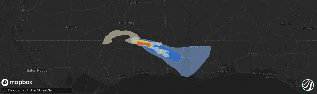
Hail Map in Lucedale, MS on May 9, 2024
The weather event in Lucedale, MS on May 9, 2024 includes Wind, Hail, and Tornado maps. 12 states and 1,008 cities were impacted and suffered possible damage. The total estimated number of properties impacted is 82.
Wind
Hail
Tornado
82
Estimated number of impacted properties by a 1.00" hail or larger64
Estimated number of impacted properties by a 1.75" hail or larger0
Estimated number of impacted properties by a 2.50" hail or largerStorm reports in Lucedale, MS
Lucedale, MS
| Date | Description |
|---|---|
| 05/09/20242:38 AM CDT | Minor roof damage and trees down. |
| 05/09/20242:30 AM CDT | Trees and power lines down behind george county middle school. |
| 05/09/20242:30 AM CDT | Damage to rocky creek catfish cottage on old hwy 63. |
All States Impacted by Hail Map on May 9, 2024
All Cities Impacted by Hail Map on May 9, 2024
- Cassatt, SC
- Hartsville, SC
- Bethune, SC
- Lamar, SC
- Bishopville, SC
- Darlington, SC
- Timmonsville, SC
- Florence, SC
- Effingham, SC
- Hartwell, GA
- Titus, AL
- Wadley, AL
- Royston, GA
- Canon, GA
- Bowersville, GA
- Wetumpka, AL
- Equality, AL
- Elberton, GA
- Roanoke, AL
- Crane Hill, AL
- Eclectic, AL
- Bowman, GA
- Dewy Rose, GA
- Addison, AL
- Arley, AL
- Cullman, AL
- Logan, AL
- Alexander City, AL
- Iva, SC
- Calhoun Falls, SC
- Cleveland, AL
- Hayden, AL
- Dadeville, AL
- Hanceville, AL
- Locust Fork, AL
- Bremen, AL
- Empire, AL
- Camp Hill, AL
- Auburn, AL
- Salem, AL
- Opelika, AL
- Greenville, GA
- Gay, GA
- Smiths Station, AL
- Fortson, GA
- Columbus, GA
- Midland, GA
- Valley, AL
- Upatoi, GA
- Box Springs, GA
- Cataula, GA
- West Point, GA
- Jacksons Gap, AL
- Butler, GA
- Reynolds, GA
- Junction City, GA
- Mauk, GA
- Hamilton, GA
- Fort Valley, GA
- Throckmorton, TX
- Woodson, TX
- Newcastle, TX
- Olney, TX
- Kathleen, GA
- Dry Branch, GA
- Perry, GA
- Bonaire, GA
- Holliday, TX
- Graham, TX
- Hawkinsville, GA
- Bamberg, SC
- Branchville, SC
- Loving, TX
- Buena Vista, GA
- Cochran, GA
- Jermyn, TX
- Chester, GA
- Reevesville, SC
- Walterboro, SC
- Smoaks, SC
- Ellaville, GA
- Wichita Falls, TX
- Bryson, TX
- Jacksboro, TX
- Sheppard Afb, TX
- Rentz, GA
- Cadwell, GA
- Round O, SC
- Eastman, GA
- Saint George, SC
- Dexter, GA
- Andersonville, GA
- Dublin, GA
- Glenwood, GA
- Vienna, GA
- Byromville, GA
- Dorchester, SC
- Cottageville, SC
- Randlett, OK
- Temple, OK
- Union Springs, AL
- Pinehurst, GA
- Tuscola, TX
- Abilene, TX
- Soperton, GA
- Mount Vernon, GA
- Alamo, GA
- Henrietta, TX
- Bowie, TX
- Chico, TX
- Uvalda, GA
- Vidalia, GA
- Lyons, GA
- Ailey, GA
- Albany, TX
- Pitts, GA
- Cordele, GA
- Tarrytown, GA
- Windthorst, TX
- Byers, TX
- Petrolia, TX
- Sylvania, GA
- Walters, OK
- Comanche, OK
- Alvord, TX
- Sunset, TX
- Goose Creek, SC
- Moncks Corner, SC
- Pittsview, AL
- Eufaula, AL
- Mill Creek, OK
- Lumpkin, GA
- Waurika, OK
- Rochelle, GA
- Midway, AL
- Duncan, OK
- Marlow, OK
- Reidsville, GA
- Glennville, GA
- Decatur, TX
- Caddo, TX
- Moran, TX
- Baxley, GA
- Bellevue, TX
- Roff, OK
- Stonewall, OK
- Ringgold, TX
- Clayton, AL
- Rush Springs, OK
- Lindsay, OK
- Bradley, OK
- Tupelo, OK
- Nocona, TX
- Surrency, GA
- Odum, GA
- Strawn, TX
- Sanger, TX
- Breckenridge, TX
- Saint Jo, TX
- Graford, TX
- Valley View, TX
- Era, TX
- Gainesville, TX
- Ludowici, GA
- Cisco, TX
- Montague, TX
- Palo Pinto, TX
- Ranger, TX
- Blanchard, OK
- Purcell, OK
- Washington, OK
- Georgetown, GA
- Morris, GA
- Mershon, GA
- Alma, GA
- Cuthbert, GA
- Whitesboro, TX
- Calvin, OK
- Norman, OK
- Tioga, TX
- Pilot Point, TX
- Noble, OK
- Patterson, GA
- Richland, GA
- Sadler, TX
- Gordonville, TX
- Bristol, GA
- San Angelo, TX
- Forestburg, TX
- Screven, GA
- Mineral Wells, TX
- Collinsville, TX
- Gunter, TX
- Howe, TX
- Muenster, TX
- Jesup, GA
- Shellman, GA
- Dawson, GA
- Scotland, TX
- Hortense, GA
- Eastland, TX
- Sherman, TX
- Lindsay, TX
- Miles, TX
- Mingus, TX
- Brunswick, GA
- Gordon, TX
- Kinta, OK
- Carbon, TX
- Bells, TX
- Whitewright, TX
- Van Alstyne, TX
- Tom Bean, TX
- Santo, TX
- Lipan, TX
- Stephenville, TX
- Bluff Dale, TX
- Bonham, TX
- Saint Simons Island, GA
- Gorman, TX
- Ravenna, TX
- Savoy, TX
- Rosston, TX
- Denison, TX
- Millsap, TX
- Tolar, TX
- De Leon, TX
- Pottsboro, TX
- Telephone, TX
- Windom, TX
- Ivanhoe, TX
- Dodd City, TX
- Bennington, OK
- Ladonia, TX
- Desdemona, TX
- Granbury, TX
- Honey Grove, TX
- Roxton, TX
- Petty, TX
- Sumner, TX
- Arthur City, TX
- Millersview, TX
- Eden, TX
- Dublin, TX
- Boswell, OK
- Powderly, TX
- Thackerville, OK
- Grant, OK
- Brookston, TX
- Cooper, TX
- Ben Franklin, TX
- Pecan Gap, TX
- Cleburne, TX
- Colbert, OK
- Rockford, AL
- Kellyton, AL
- Albany, GA
- Tallassee, AL
- Sylvester, GA
- Ector, TX
- Paris, TX
- Godley, TX
- Nemo, TX
- Melvin, TX
- Enloe, TX
- Lake Creek, TX
- Hendrix, OK
- Hico, TX
- Pattonville, TX
- Bessemer, AL
- Jasper, FL
- Doerun, GA
- Poulan, GA
- Deport, TX
- Bogata, TX
- Iredell, TX
- Lohn, TX
- Paint Rock, TX
- Birmingham, AL
- Helena, AL
- Bokchito, OK
- Rainbow, TX
- Brady, TX
- Rio Vista, TX
- Talco, TX
- Mount Pleasant, TX
- Covington, TX
- Grandview, TX
- Blum, TX
- Pelham, AL
- Walnut Springs, TX
- Glen Rose, TX
- Clarksville, TX
- Annona, TX
- Cranfills Gap, TX
- Meridian, TX
- Itasca, TX
- Hillsboro, TX
- Avery, TX
- Alabaster, AL
- Columbiana, AL
- Chelsea, AL
- Cameron, WV
- Milford, TX
- De Kalb, TX
- Clifton, TX
- Kopperl, TX
- Morgan, TX
- Voca, TX
- Fredonia, TX
- San Saba, TX
- Calera, AL
- Hamilton, TX
- Jonesboro, TX
- Pontotoc, TX
- Mason, TX
- Valley Spring, TX
- Gatesville, TX
- Valley Mills, TX
- Sterrett, AL
- Columbus, MS
- Vandiver, AL
- Waco, TX
- Mertens, TX
- Bynum, TX
- Frost, TX
- Crawford, TX
- Artesia, MS
- Yazoo City, MS
- Shelby, AL
- Malone, TX
- Castell, TX
- Llano, TX
- Oglesby, TX
- Preston, MS
- Mart, TX
- Riesel, TX
- Berry, AL
- Groesbeck, TX
- Philadelphia, MS
- Art, TX
- De Kalb, MS
- Steens, MS
- Ethelsville, AL
- Benton, MS
- Morgantown, WV
- Vincent, AL
- Maidsville, WV
- Osage, WV
- McGregor, TX
- Dawson, TX
- Hubbard, TX
- Millport, AL
- Oakman, AL
- Oakwood, TX
- Fairfield, TX
- Fayette, AL
- Amesville, OH
- Glouster, OH
- Granville, WV
- Scooba, MS
- Sylacauga, AL
- Mexia, TX
- Woodway, TX
- Axtell, TX
- Marietta, OK
- Fredericksburg, TX
- Willow City, TX
- Pell City, AL
- Millfield, OH
- Jacksonville, OH
- Trimble, OH
- Coolidge, TX
- Wortham, TX
- Carrollton, AL
- Emelle, AL
- Aliceville, AL
- Round Mountain, TX
- Eutaw, AL
- Chesterhill, OH
- Moody, TX
- Lorena, TX
- Vaughan, MS
- Kennedy, AL
- Gordo, AL
- Northport, AL
- Starkville, MS
- Marlin, TX
- Parrish, AL
- Johnson City, TX
- Reform, AL
- Pickens, MS
- Thornton, TX
- Adger, AL
- Troy, TX
- Eddy, TX
- Kosse, TX
- Fairfield, AL
- Coker, AL
- Lexington, MS
- Wilsonville, AL
- Dripping Springs, TX
- Blanco, TX
- Camden, MS
- Quinton, AL
- Knoxville, AL
- Ralph, AL
- Lott, TX
- Coushatta, LA
- Weogufka, AL
- Frierson, LA
- Keithville, LA
- Stonewall, LA
- Tuscaloosa, AL
- Groveton, TX
- West Monroe, LA
- Buhl, AL
- Franklin, TX
- Goodman, MS
- Kosciusko, MS
- Shreveport, LA
- Bethany, LA
- De Berry, TX
- Waskom, TX
- Greenwood, LA
- Monroe, LA
- Jewett, TX
- Lampasas, TX
- Ashland, LA
- Bremond, TX
- Macon, MS
- Brookwood, AL
- Corrigan, TX
- Brooksville, MS
- Eros, LA
- Masontown, WV
- Rosebud, TX
- Temple, TX
- Wimberley, TX
- Bankston, AL
- Carthage, MS
- Marquez, TX
- Kempner, TX
- Rayville, LA
- Hye, TX
- Adamsville, AL
- Mulga, AL
- Moscow, TX
- Driftwood, TX
- Moundville, AL
- Dolomite, AL
- Huntsville, TX
- Trinity, TX
- Durant, MS
- Elm Grove, LA
- Fosters, AL
- Briggs, TX
- Docena, AL
- Buda, TX
- Normangee, TX
- Centerville, TX
- San Marcos, TX
- Kyle, TX
- Ringgold, LA
- Bertram, TX
- Burlington, TX
- Burnet, TX
- West, MS
- McCalla, AL
- Harpersville, AL
- Graysville, AL
- Mount Olive, AL
- Fultondale, AL
- Tucumcari, NM
- Delhi, LA
- Killeen, TX
- Cottondale, AL
- Saline, LA
- Apple Springs, TX
- Canyon Lake, TX
- New Braunfels, TX
- Bossier City, LA
- Florence, TX
- Jarrell, TX
- Georgetown, TX
- Leona, TX
- Midway, TX
- Crockett, TX
- Jamestown, LA
- Seguin, TX
- Elrod, AL
- Echola, AL
- Clanton, AL
- Childersburg, AL
- Castor, LA
- Brent, AL
- Gardendale, AL
- Trussville, AL
- Oakhurst, TX
- Trafford, AL
- Pinson, AL
- Morris, AL
- Warrior, AL
- Kimberly, AL
- Diboll, TX
- Duncanville, AL
- Fischer, TX
- Spring Branch, TX
- Brookside, AL
- Chester, TX
- Onalaska, TX
- Kingsbury, TX
- Maxwell, TX
- Martindale, TX
- Lufkin, TX
- Luling, TX
- Lockhart, TX
- Wallis, TX
- Schulenburg, TX
- Weimar, TX
- La Grange, TX
- East Bernard, TX
- Richmond, TX
- Red Rock, TX
- Manvel, TX
- Sugar Land, TX
- Muldoon, TX
- Eagle Lake, TX
- Dale, TX
- Rosanky, TX
- Fresno, TX
- Glidden, TX
- Waelder, TX
- Smithville, TX
- Columbus, TX
- Cat Spring, TX
- Sealy, TX
- Rosenberg, TX
- Harwood, TX
- Alleyton, TX
- Missouri City, TX
- Rosharon, TX
- Flatonia, TX
- Bartlett, TX
- Granger, TX
- Centreville, AL
- Tishomingo, OK
- Mangham, LA
- Winnsboro, LA
- Durant, OK
- Dora, AL
- Odenville, AL
- Remlap, AL
- Oneonta, AL
- Springville, AL
- Lovelady, TX
- Lawley, AL
- Moody, AL
- Ryan, OK
- Hall Summit, LA
- Taylor, TX
- Grady, NM
- Ashville, AL
- Randolph, AL
- Maplesville, AL
- Bedias, TX
- Baskin, LA
- Livingston, TX
- Madisonville, TX
- Oak Ridge, LA
- Vaiden, MS
- Mansfield, LA
- Collinston, LA
- Hutto, TX
- Gonzales, TX
- Cropwell, AL
- Altoona, AL
- Campti, LA
- Fitzpatrick, AL
- Bastrop, LA
- Newellton, LA
- Ragland, AL
- Natchitoches, LA
- Epps, LA
- Pioneer, LA
- Coupland, TX
- Elgin, TX
- Thrall, TX
- Zavalla, TX
- Lexington, TX
- Goldonna, LA
- Robeline, LA
- Natchez, LA
- Steele, AL
- Deatsville, AL
- Bonita, LA
- Tallulah, LA
- Hardaway, AL
- Marbury, AL
- Redwood, MS
- Colmesneil, TX
- Pointblank, TX
- Crawford, MS
- Vicksburg, MS
- Columbia, LA
- McDade, TX
- Montgomery, LA
- Fort Necessity, LA
- Paige, TX
- Lincoln, TX
- Woodstock, AL
- West Blocton, AL
- Raymond, MS
- Edwards, MS
- Coldspring, TX
- Montgomery, AL
- New Waverly, TX
- Utica, MS
- Satartia, MS
- Hurtsboro, AL
- Tuskegee, AL
- Prattville, AL
- Giddings, TX
- Woodville, TX
- Atlanta, LA
- Eudora, AR
- Tuskegee Institute, AL
- Cloutierville, LA
- Melrose, LA
- Bolton, MS
- Shorter, AL
- Pike Road, AL
- Jones, LA
- Clinton, MS
- Oak Grove, LA
- Goodrich, TX
- Notasulga, AL
- Wisner, LA
- Gilbert, LA
- Jasper, TX
- Colfax, LA
- Ledbetter, TX
- Cecil, AL
- Shepherd, TX
- Phenix City, AL
- Jackson, MS
- Willis, TX
- Flora, MS
- Winnfield, LA
- Hazlehurst, MS
- Crystal Springs, MS
- Port Gibson, MS
- Hermanville, MS
- Fort Davis, AL
- Carmine, TX
- Fayette, MS
- Union Church, MS
- Madison, MS
- Lena, LA
- Waverly, AL
- Pattison, MS
- Canton, MS
- Flowood, MS
- Brandon, MS
- Round Top, TX
- Saint Joseph, LA
- Dry Prong, LA
- Georgetown, LA
- Pollock, LA
- Ridgeland, MS
- Bentley, LA
- Saratoga, TX
- Cleveland, TX
- Vernon, AL
- Lena, MS
- Morton, MS
- Trout, LA
- Jena, LA
- Waverly Hall, GA
- Burton, TX
- Fayetteville, TX
- New Ulm, TX
- Conehatta, MS
- Lake, MS
- Industry, TX
- Kirbyville, TX
- Newton, TX
- Brenham, TX
- Forest, MS
- Pelahatchie, MS
- Boyce, LA
- Elmer, LA
- Deville, LA
- Pineville, LA
- Ball, LA
- Silver City, MS
- Thomaston, AL
- Brookhaven, MS
- Wesson, MS
- Ellerslie, GA
- Alexandria, LA
- Natchez, MS
- Uniontown, AL
- Raleigh, MS
- Mendenhall, MS
- Magee, MS
- Catherine, AL
- Safford, AL
- Burkeville, TX
- Newton, MS
- Lawrence, MS
- Pulaski, MS
- Americus, GA
- Plains, GA
- Bellville, TX
- Decatur, MS
- Jonesville, LA
- Little Rock, MS
- Mize, MS
- Leslie, GA
- Hickory, MS
- Meridian, MS
- Chunky, MS
- Collinsville, MS
- Louin, MS
- Jemison, AL
- Lecompte, LA
- Taylorsville, MS
- Bay Springs, MS
- Marion Junction, AL
- Monterey, LA
- McCall Creek, MS
- Bailey, MS
- Thorsby, AL
- Collins, MS
- Prentiss, MS
- Mount Olive, MS
- Newhebron, MS
- Cobb, GA
- Pachuta, MS
- Enterprise, MS
- Marion, MS
- Orrville, AL
- Laurel, MS
- Lisman, AL
- Ward, AL
- Rose Hill, MS
- Heidelberg, MS
- Selma, AL
- Livingston, AL
- Bogue Chitto, MS
- York, AL
- Quitman, MS
- Paulding, MS
- Vossburg, MS
- Butler, AL
- Shubuta, MS
- Waynesboro, MS
- Tougaloo, MS
- Pearl, MS
- Richland, MS
- Soso, MS
- Blountsville, AL
- Elmore, AL
- Jacksonville, GA
- Rhine, GA
- Sontag, MS
- Monticello, MS
- Smithdale, MS
- Linden, AL
- Jones, AL
- Plantersville, AL
- Stonewall, MS
- Roxie, MS
- Silver Creek, MS
- Stringer, MS
- Camden, AL
- Sardis, AL
- Jayess, MS
- Ruth, MS
- Millbrook, AL
- Verbena, AL
- Minter, AL
- Coosada, AL
- Broxton, GA
- Faunsdale, AL
- Oak Vale, MS
- Foxworth, MS
- Columbia, MS
- Gilbertown, AL
- Melvin, AL
- Silas, AL
- Needham, AL
- Toxey, AL
- Campbell, AL
- Thomasville, AL
- Coffeeville, AL
- Jachin, AL
- Marion, AL
- Carson, MS
- Seminary, MS
- Liberty, MS
- Bassfield, MS
- Jackson, AL
- Kokomo, MS
- Magnolia, MS
- Summit, MS
- Purvis, MS
- Lumberton, MS
- Vidalia, LA
- Poplarville, MS
- Angie, LA
- Kentwood, LA
- Dickinson, AL
- Grove Hill, AL
- Osyka, MS
- Mccomb, MS
- Hattiesburg, MS
- Bay Minette, AL
- McDavid, FL
- Lucedale, MS
- Chunchula, AL
- Leakesville, MS
- Citronelle, AL
- Jay, FL
- Crestview, FL
- Baker, FL
- McLain, MS
- Beaumont, MS
- Axis, AL
- Anderson, SC
- Peterman, AL
- Beatrice, AL
- Vredenburgh, AL
- Brooklyn, MS
- Wiggins, MS
- Brewton, AL
- New Augusta, MS
- Rutledge, AL
- Luverne, AL
- Goshen, AL
- Pine Apple, AL
- Grady, AL
- Ramer, AL
- Mathews, AL
- Troy, AL
- Evergreen, AL
- Georgiana, AL
- McKenzie, AL
- Glenwood, AL
- Daleville, AL
- Chancellor, AL
- Neely, MS
- Perkinston, MS
- Greenville, AL
- Forest Home, AL
- Moss Point, MS
- Wilmer, AL
- Semmes, AL
- Eight Mile, AL
- Mobile, AL
- Newton, AL
- Slocomb, AL
- Hartford, AL
- Kinston, AL
- Saucier, MS
- Opp, AL
- Fort Deposit, AL
- Fort Rucker, AL
- Enterprise, AL
- Elba, AL
- Samson, AL
- Andalusia, AL
- Banks, AL
- Louisville, AL
- Clio, AL
- Vancleave, MS
- Saraland, AL
- Grand Bay, AL
- Daphne, AL
- Theodore, AL
- Irvington, AL
- Midland City, AL
- Honoraville, AL
- Brundidge, AL
- Dothan, AL
- Lapine, AL
- Highland Home, AL
- Loxley, AL
- Stapleton, AL
- Robertsdale, AL
- Fairhope, AL
- Florala, AL
- Headland, AL
- Satsuma, AL
- Creola, AL
- Coden, AL
- Silverhill, AL
- Summerdale, AL
- Foley, AL
- Century, FL
- Newville, AL
- Columbia, AL
- Atmore, AL
- Molino, FL
- Cowarts, AL
- Webb, AL
- Magnolia Springs, AL
- Gulf Shores, AL
- Seminole, AL
- Elberta, AL
- Bon Secour, AL
- Dozier, AL
- Brantley, AL
- Jack, AL
- Ariton, AL
- Clopton, AL
- Skipperville, AL
- Orange Beach, AL
- Cantonment, FL
- Lillian, AL
- Pensacola, FL
- Fort Gaines, GA
- Ashford, AL
- Abbeville, AL
- Milton, FL
- Holt, FL
- Donalsonville, GA
- Colquitt, GA
- Gulf Breeze, FL
- Bagdad, FL
- Eglin Afb, FL
- Navarre, FL
- Jakin, GA
- Gordon, AL
- Blakely, GA
- Weston, GA
- Preston, GA
- Cottonwood, AL
- Pansey, AL
- Wing, AL
- Damascus, GA
- Leary, GA
- Defuniak Springs, FL
- Hurlburt Field, FL
- Fort Walton Beach, FL
- Mary Esther, FL
- Shalimar, FL
- Valparaiso, FL
- Niceville, FL
- Miramar Beach, FL
- Destin, FL
- Freeport, FL
- Santa Rosa Beach, FL
- Vernon, FL
- Panama City Beach, FL
- Inlet Beach, FL
- Ponce De Leon, FL
- Bonifay, FL
- Caryville, FL
- Ebro, FL
- Westville, FL
- Newton, GA
- Elko, GA
- Bainbridge, GA
- Brinson, GA
- Iron City, GA
- Camilla, GA
- Panama City, FL
- Lynn Haven, FL
- Pelham, GA
- Climax, GA
- Whigham, GA
- Cairo, GA
- Alford, FL
- Chipley, FL
- Attapulgus, GA
- Quincy, FL
- Port Saint Joe, FL
- Wewahitchka, FL
- Tallahassee, FL
- Sumner, GA
- Meigs, GA
- Ochlocknee, GA
- Waycross, GA
- Midway, FL
- Thomasville, GA
- Moultrie, GA
- Coolidge, GA
- Havana, FL
- Pavo, GA
- Boston, GA
- Dixie, GA
- Flomaton, AL
- Greenville, FL
- Madison, FL
- Pinetta, FL
- Jennings, FL
- Arlington, GA
- Omaha, GA
- Mullin, TX
- Bridgeport, TX
- Paradise, TX
- Springtown, TX
- Comanche, TX
- Weatherford, TX
- Gustine, TX
- Poolville, TX


