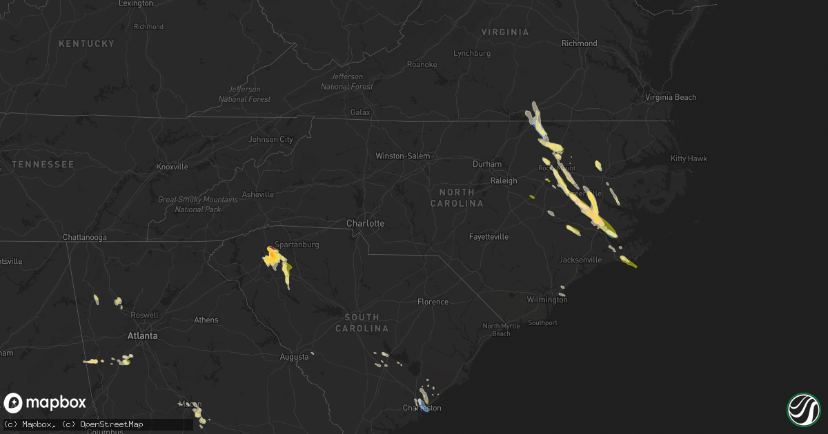
Hail Map in North Carolina on May 9, 2023
Get this storm
May 9 map
$229
one time, instant access
Download today. No call, no setup
Keep the $229
Bought the map and want the full workflow? Apply the entire $229 to a subscription within 7 days. None of it is wasted.
Every map, not just this one
This buys you this map. Subscription and you get every map we run, in the markets you choose from a few cities to whole states to nationwide. Plus real-time alerts the moment a storm fires.
Contact data
Name, contact info, occupancy, even credit band for addresses in the footprint. You go from where it hit to who to call.
Become the source they trust
Unlimited branding weather history reports on demand. You already have the documented answer ready for the property owner, and you are the one who showed up with it.
Property data and RoofTrace estimates
Pull up any address you have got, its value and the exact code rules for that jurisdiction, straight from One Click Code. Then RoofTrace estimates the squares, pitch, and roof value, priced the way you price.
Storm reports in North Carolina
North Carolina
| Date | Description |
|---|---|
| 05/09/20236:35 PM CDT | Nws employee reported trees uprooted and snapped on hwy 33 w north of falkland. |
| 05/09/20236:24 PM CDT | Public report of quarter sized hail in williamston... Relayed through social media. |
| 05/09/20236:22 PM CDT | Power poles down on nc 33 near edgecombe/pitt county line. |
| 05/09/20236:15 PM CDT | Roof damage to a mobile home. |
| 05/09/20236:10 PM CDT | Report of tree down shortly after 7pm. |
| 05/09/20236:07 PM CDT | Spotter reported quarter sized hail in farmville... Nc. |
| 05/09/20235:45 PM CDT | 911 center reports numerous trees downed across the county... With the greatest amount of damage starting in the battleboro area... Which then spread southeastward acro |
| 05/09/20235:45 PM CDT | Located at nc 42 and bridgersville rd. |
| 05/09/20235:38 PM CDT | Trees down on power lines. |
| 05/09/20235:33 PM CDT | A local report indicates 1.00 inch wind near SHARPSBURG |
| 05/09/20235:15 PM CDT | Carteret-craven electric cooperative reported limbs on powerlines at the intersection of barnes dr. And sound dr. In emerald isle. |
| 05/09/20235:03 PM CDT | Trees down in the macon area. |
| 05/09/20234:46 PM CDT | Public reported quarter sized hail in beaufort. |
| 05/09/20234:41 PM CDT | Mping report of quarter sized hail. |
| 05/09/20234:36 PM CDT | Multiple trees down on broad creek road. |
| 05/09/20234:35 PM CDT | A local report indicates 1.00 inch wind near 3 NW CRAB POINT VILLAGE |
| 05/09/20234:30 PM CDT | Public measured 73 mph gust. |
| 05/09/20234:22 PM CDT | Corrects location and time of previous tstm wnd dmg report from 1 e river road. Multiple trees down on broad creek road. |
| 05/09/20234:21 PM CDT | Large pine tree snapped in fairfield harbor. Time estimated from radar. |
| 05/09/20234:14 PM CDT | ~160 trees down at harbour pointe golf club. Time estimated from radar. |
| 05/09/20234:12 PM CDT | Trees down on power lines. |
| 05/09/20234:10 PM CDT | Public report of 1 inch hail. Time estimated from radar. |
| 05/09/20234:07 PM CDT | Public reported quarter sized hail in havelock... Relayed through social media. Time based on radar. |
| 05/09/20234:01 PM CDT | Trained spotter reports wind gusts around 60-65 mph and penny size hail near the intersection of hwy 17 and state rd 43. Extensive tree debris in the area. |
| 05/09/20233:51 PM CDT | Public sent picture of quarter sized hail. Time estimated from radar. |
| 05/09/20233:48 PM CDT | Significant amount of wind blown hail fell... Causing significant damage to siding. Pictures submitted via facebook. |
| 05/09/20233:45 PM CDT | Wind driven hail damage to several mobile homes along bear hole road in vanceboro. Additionally... A nearby barn was blown apart... And several large trees were uproote |
| 05/09/20233:25 PM CDT | Public report of quarter size hail in ayden. |
| 05/09/20233:21 PM CDT | Delayed report. Significant amount of accumulated hail fell. The hail damaged siding and vehicles. Report via twitter. Time estimated based on radar. |
| 05/09/20233:18 PM CDT | Delayed report. Numerous trees uprooted. Trailers reported flipped on speight seed farm road in the ballards cross roads area. Quarter size hail reported for 10 minutes |
| 05/09/20233:12 PM CDT | Picture submitted of quarter size hail off chinquapin rd east of farmville. Time estimated from radar. |
| 05/09/20233:10 PM CDT | Delayed report. Power lines blown down in the bell arthur area. Reported via the reflector. Time estimated based on radar. |
| 05/09/20233:00 PM CDT | Public report of multiple tree limbs down. Tree limbs had a a diameter of 3 1/2 inches. Also reports of damage to outdoor structures from tstm wind gusts. |
| 05/09/20232:52 PM CDT | A local report indicates 1.00 inch wind near 1 ESE MICRO |
| 05/08/20238:05 PM CDT | Public reported large limbs down in the trent woods area. |
| 05/08/20237:36 PM CDT | Report of tree down across nc 118 near butler ford rd. |
| 05/08/20237:02 PM CDT | Public report of ping pong sized hail in simpson... Nc. |
All States Impacted by Hail Map on May 9, 2023
Cities Impacted by Hail Map on May 9, 2023
- El Dorado, AR
- Horatio, AR
- De Queen, AR
- Dixon, KY
- Sebree, KY
- Slaughters, KY
- Manitou, KY
- Saint Francis, KS
- McDonald, KS
- Winona, KS
- Monument, KS
- Colby, KS
- Scott City, KS
- Atwood, KS
- Abilene, KS
- Enterprise, KS
- Ludell, KS
- Herndon, KS
- Gem, KS
- Rexford, KS
- Selden, KS
- Oberlin, KS
- Hoxie, KS
- Beaver City, NE
- Oxford, NE
- Edison, NE
- Arapahoe, NE
- Orleans, NE
- Hendley, NE
- Jennings, KS
- Dresden, KS
- Stamford, NE
- Norcatur, KS
- Alma, NE
- Norton, KS
- Lenora, KS
- Almena, KS
- Prairie View, KS
- Long Island, KS
- Phillipsburg, KS
- Republican City, NE
- Hill City, KS
- Logan, KS
- Naponee, NE
- Bloomington, NE
- Kensington, KS
- Agra, KS
- Kirwin, KS
- Glade, KS
- Riverton, NE
- Franklin, NE
- Smith Center, KS
- Gaylord, KS
- Cedar, KS
- Athol, KS
- Portis, KS
- Osborne, KS
- Alton, KS
- Stockton, KS
- Woodston, KS
- Bogue, KS
- Damar, KS
- Palco, KS
- Plainville, KS
- Mankato, KS
- Lebanon, KS
- Downs, KS
- Webber, KS
- Esbon, KS
- Cawker City, KS
- Glen Elder, KS
- Natoma, KS
- Tipton, KS
- Beloit, KS
- Randall, KS
- Jewell, KS
- Ellis, KS
- Catharine, KS
- Victoria, KS
- Paradise, KS
- Formoso, KS
- Waldo, KS
- Russell, KS
- Luray, KS
- Norway, KS
- Courtland, KS
- Jamestown, KS
- Concordia, KS
- Simpson, KS
- Glasco, KS
- Lucas, KS
- Scandia, KS
- Delphos, KS
- Miltonvale, KS
- Aurora, KS
- Clyde, KS
- Minneapolis, KS
- Clay Center, KS
- Bunker Hill, KS
- Bloomington, TX
- Victoria, TX
- Benkelman, NE
- Bird City, KS
- Max, NE
- Stratton, NE
- Bertrand, NE
- Trenton, NE
- Paxton, NE
- Chapman, KS
- Holbrook, NE
- Burr Oak, KS
- New Orleans, LA
- Arnaudville, LA
- Belleville, KS
- Wilsonville, NE
- Lincoln, AL
- Riverside, AL
- Kermit, WV
- Wilsondale, WV
- Crum, WV
- Louise, TX
- Clayton, KS
- Penokee, KS
- Lolita, TX
- Oakley, KS
- Cambridge, NE
- Holdrege, NE
- Hays, KS
- Sylvan Grove, KS
- Clifton, KS
- Morganville, KS
- Longford, KS
- Palmer, KS
- Solomon, KS
- Dorrance, KS
- Bennington, KS
- Talmage, KS
- Green, KS
- Wakefield, KS
- Wilson, KS
- Junction City, KS
- Riley, KS
- Leonardville, KS
- Milford, KS
- Fort Riley, KS
- Woodbine, KS
- Randolph, KS
- Manhattan, KS
- Ogden, KS
- Roopville, GA
- Franklin, GA
- Ellsworth, KS
- Newnan, GA
- Sharpsburg, GA
- Peachtree City, GA
- Lorraine, KS
- Herington, KS
- Tampa, KS
- Ramona, KS
- White City, KS
- Gypsum, KS
- Hope, KS
- Alta Vista, KS
- Dwight, KS
- Council Grove, KS
- Springfield, MO
- Republic, MO
- Brookline, MO
- Lost Springs, KS
- Burdick, KS
- Willard, MO
- Saint George, KS
- Alma, KS
- Wilsey, KS
- Lincolnville, KS
- La Crosse, KS
- Bison, KS
- Strong City, KS
- Marion, KS
- Elmdale, KS
- Wamego, KS
- Olsburg, KS
- Pleasant Hope, MO
- Brighton, MO
- Walnut Grove, MO
- Rush Center, KS
- Otis, KS
- Dawson, MN
- Boyd, MN
- Montevideo, MN
- Paxico, KS
- Allen, KS
- McFarland, KS
- Belvue, KS
- Kellyton, AL
- Alexander City, AL
- Jacksons Gap, AL
- Morrisville, MO
- Aldrich, MO
- Selma, NC
- Kenly, NC
- Wilson, NC
- Elm City, NC
- Saint Marys, KS
- Maple Hill, KS
- Eskridge, KS
- Admire, KS
- Cottonwood Falls, KS
- Americus, KS
- Emporia, KS
- Cedar Point, KS
- Olpe, KS
- Matfield Green, KS
- Farmville, NC
- Fountain, NC
- Walstonburg, NC
- Greenville, NC
- Winterville, NC
- Ayden, NC
- Harveyville, KS
- Topeka, KS
- Reading, KS
- Grifton, NC
- Vanceboro, NC
- Grimesland, NC
- Bolivar, MO
- Larned, KS
- Albert, KS
- Great Bend, KS
- Half Way, MO
- Polk, MO
- Taylors, SC
- Greenville, SC
- Greer, SC
- Burlingame, KS
- Osage City, KS
- Ernul, NC
- New Bern, NC
- Louisburg, MO
- Grantsboro, NC
- Cartersville, GA
- Simpsonville, SC
- Auburn, KS
- Neosho Rapids, KS
- Hartford, KS
- Pawnee Rock, KS
- Urbana, MO
- Hermitage, MO
- Buffalo, MO
- Deep Run, NC
- Kinston, NC
- Trenton, NC
- Tuskegee, AL
- Eureka, KS
- Madison, KS
- Hamilton, KS
- Vassar, KS
- Lyndon, KS
- Quenemo, KS
- Overbrook, KS
- Pomona, KS
- Burlington, KS
- Virgil, KS
- Scranton, KS
- Melvern, KS
- Waverly, KS
- Gridley, KS
- Lebo, KS
- Yates Center, KS
- Williamsburg, KS
- Neosho Falls, KS
- Toronto, KS
- Princeton, KS
- Colony, KS
- Garnett, KS
- Ottawa, KS
- Westphalia, KS
- Le Roy, KS
- Richmond, KS
- Welda, KS
- Neal, KS
- Mauldin, SC
- Carbondale, KS
- Baldwin City, KS
- Preston, MO
- Sheldon, MO
- Lamar, MO
- Rome, GA
- Wellsville, KS
- St John, KS
- Gray Court, SC
- Fountain Inn, SC
- Enoree, SC
- La Crosse, VA
- South Hill, VA
- Woodruff, SC
- Bracey, VA
- Laurens, SC
- Baskerville, VA
- Boydton, VA
- Macon, NC
- Warrenton, NC
- Littleton, NC
- Greeley, KS
- Edgerton, KS
- Paola, KS
- Lane, KS
- Rantoul, KS
- Osawatomie, KS
- Moran, KS
- Kincaid, KS
- Norlina, NC
- Jerico Springs, MO
- El Dorado Springs, MO
- Walker, MO
- Harwood, MO
- Calico Rock, AR
- Piedmont, SC
- Nashville, NC
- Rocky Mount, NC
- Pinetops, NC
- Hollister, NC
- Enfield, NC
- Schell City, MO
- Whitakers, NC
- Bronson, KS
- Mapleton, KS
- Centerville, KS
- Parker, KS
- Mound City, KS
- La Cygne, KS
- Fulton, KS
- Blue Mound, KS
- Fontana, KS
- Prescott, KS
- Spring Hill, KS
- Beulah, ND
- Hebron, ND
- Battleboro, NC
- Macclesfield, NC
- Lewiston Woodville, NC
- Windsor, NC
- Hudson, KS
- Rozel, KS
- Macksville, KS
- Pleasanton, KS
- Louisburg, KS
- Uniontown, KS
- Fort Scott, KS
- Redfield, KS
- Stafford, KS
- La Grange, NC
- Goldsboro, NC
- Grenora, ND
- Williston, ND
- Mountain Home, AR
- Montgomery, LA
- Salina, KS
- Millerville, AL
- Clontarf, MN
- Benson, MN
- Gorham, KS
- Cross Timbers, MO
- Zachary, LA
- Pride, LA
- Lincoln, KS
- Roxie, MS
- Morehead City, NC
- Newport, NC
- Taft, TX
- Tibbie, AL
- Deer Park, AL
- Stantonsburg, NC
- Macon, GA
- Jeffersonville, GA
- Danville, GA
- Bushton, KS
- McIntosh, AL
- Realitos, TX
- Pell City, AL
- Talladega, AL
- Aransas Pass, TX
- Ingleside, TX
- Tyrone, GA
- Fayetteville, GA
- Beaufort, NC
- Dadeville, AL
- Dry Branch, GA
- Tuskegee Institute, AL
- Hancock, MN
- Gladys, VA
- Colfax, LA
- Lafayette, AL
- Five Points, AL
- Roanoke, AL
- Goodwater, AL
- Camp Hill, AL
- Hays, MT
- Harlem, MT
- Shields, ND
- Sylacauga, AL
- Walker, KS
- Bois D Arc, MO
- Ash Grove, MO
- Kanopolis, KS
- Chase City, VA
- Woodland, AL
- Cheyenne, WY
- Revere, MN
- Walnut Grove, MN
- Lamberton, MN
- Havelock, NC
- Burns, WY
- Kenbridge, VA
- Victoria, VA
- Lunenburg, VA
- Freer, TX
- Portland, TX
- Corpus Christi, TX
- Wilmington, NC
- Kilgore, TX
- Wedowee, AL
- Bingham Lake, MN
- Windom, MN
- Claflin, KS
- Pearl River, LA
- Perdido, AL
- Watson, MN
- White, GA
- Jonesboro, LA
- Liebenthal, KS
- Nekoma, KS
- McCracken, KS
- El Dorado, KS
- Agenda, KS
- Natchez, MS
- Florien, LA
- Snow Hill, NC
- Many, LA
- Hoisington, KS
- Alpine, AL
- Rockford, AL
- Notasulga, AL
- Lena, LA
- Wagarville, AL
- Lizella, GA
- Shelby, AL
- Minneota, MN
- Clarkfield, MN
- Tescott, KS
- Picayune, MS
- Hampstead, NC
- Childersburg, AL
- Zwolle, LA
- Rayville, LA
- Clever, MO
- Billings, MO
- Garrison, TX
- Tow, TX
- Wadley, AL
- Iuka, KS
- Glen Ullin, ND
- Turon, KS
- Burdett, KS
- Hanston, KS
- Ness City, KS
- Jetmore, KS
- Byers, KS
- Pratt, KS
- Bronaugh, MO
- Liberal, MO
- Amsterdam, MO
- Drexel, MO
- Butler, MO
- Adrian, MO
- Amoret, MO
- Foster, MO
- Hume, MO
- Lewis, KS
- Kinsley, KS
- Garfield, KS
- New Salem, ND
- Hazen, ND
- Chocowinity, NC
- Bath, NC
- Pinetown, NC
- Sawyer, KS
- Charleston, SC
- Mount Pleasant, SC
- North Charleston, SC
- Sullivans Island, SC
- Denver, CO
- Thornton, CO
- Brighton, CO
- Belpre, KS
- Fort Lupton, CO
- Mandan, ND
- Center, ND
- Isabel, KS
- Medicine Lodge, KS
- Commerce City, CO
- Everton, MO
- Nixa, MO
- Ozark, MO
- Bismarck, ND
- Hudson, CO
- George West, TX
- Sandia, TX
- Three Rivers, TX
- Marionville, MO
- Aurora, MO
- Mount Vernon, MO
- Alexander, KS
- Albin, WY
- Meriden, WY
- Bazine, KS
- Windsor, CO
- Eaton, CO
- Severance, CO
- Greeley, CO
- Ault, CO
- Nashville, KS
- Wasta, SD
- Morrill, NE
- Smithwick, SD
- Mitchell, NE
- Selfridge, ND
- Crawford, NE
- Watauga, SD
- Lyman, NE
- McIntosh, SD
- Howes, SD
- Faith, SD
- Harrison, NE
- Owanka, SD
- Flasher, ND
- Oelrichs, SD
- Oral, SD
- Dupree, SD
- Saint Anthony, ND
- Pine Ridge, SD
- Calliham, TX
- Brownell, KS
- Fort Collins, CO
- Timnath, CO
- Ransom, KS
- Henderson, CO
- Orange Grove, TX
- Wiggins, CO
- Harrisburg, NE
- Goddard, KS
- Wichita, KS
- Fort Morgan, CO
- Boulder, CO
- Longmont, CO
- Niwot, CO
- Steele, ND
- Dawson, ND
- Tappen, ND
- Erie, CO
- Lafayette, CO
- Berthoud, CO
- Mead, CO
- Dacono, CO
- Firestone, CO
- Johnstown, CO
- Platteville, CO
- Milliken, CO
- Frederick, CO
- Gering, NE
- Atlantic Beach, NC
- Scottsbluff, NE
- Starbuck, MN
- La Salle, CO
- Kersey, CO
- Garland, KS
- Deerfield, MO
- Richards, MO
- Milo, MO
- Moundville, MO
- Nevada, MO
- Rockville, MO
- Rich Hill, MO
- Lockwood, MO
- Golden City, MO
- Humansville, MO
- Greenfield, MO
- Stockton, MO
- Arcola, MO
- Fair Play, MO
- Dadeville, MO
- Collins, MO
- South Greenfield, MO
- Jasper, MO
- Fair Grove, MO
- Strafford, MO
- Dunnegan, MO
- Miller, MO
- Halltown, MO
- Rogersville, MO
- Gilcrest, CO
- Williamston, NC
- Jamesville, NC
- Ladson, SC
- West Blocton, AL
- Centreville, AL
- Windyville, MO
- Huger, SC
- Collyer, KS
- Quinter, KS
- Driscoll, ND
- Richardton, ND
- Roggen, CO
- Goose Creek, SC
- Ellendale, ND
- Johns Island, SC
- Lansford, ND
- Highlandville, MO
- Chatham, LA
- Coats, KS
- Zenda, KS
- Cunningham, KS
- Spivey, KS
- Washington, NC
- Mountain View, AR
- Duncanville, AL
- Tuscaloosa, AL
- Lyons, CO
- Berthold, ND
- Carpio, ND
- Marathon, TX
- Plevna, KS
- Pierpont, SD
- Andover, SD
- Groton, SD
- Glenburn, ND
- Loveland, CO
- Calhoun, MO
- Clinton, MO
- Menoken, ND
- Sterling, ND
- Waterloo, SC
- Pelzer, SC
- Lagrange, WY
- Windsor, MO
- Solen, ND
- Dodge, ND
- Hillsdale, WY
- Faulkton, SD
- Maben, MS
- Pheba, MS
- Appleton City, MO
- Napoleon, ND
- Hawk Springs, WY
- Elloree, SC
- Santee, SC
- Osceola, MO
- Montrose, MO
- McCalla, AL
- Eutawville, SC
- Runge, TX
- Pine Bluffs, WY
- Oronogo, MO
- Medina, ND
- Tarboro, NC
- Mountainburg, AR
- La Russell, MO
- Lumpkin, GA
- Sarcoxie, MO
- Fort Stockton, TX
- Tilden, TX
- Clayton, AL
- Alice, TX
- Roseglen, ND
- Ryder, ND
- Reeds, MO
- Carthage, MO
- Merino, CO
- Mathis, TX
- Brent, AL
- Silver Creek, GA
- Flaxton, ND
- Arlington, KS
- Cottondale, AL
- Mize, MS
- Taylorsville, MS
- Castalia, NC
- Wakeeney, KS
- Helena, AL
- Montevallo, AL
- Brierfield, AL
- Regan, ND
- Lowry City, MO
- Brooksville, MS
- McDavid, FL
- Century, FL
- Kenedy, TX
- Aiken, SC
- Garrison, ND
- Cordesville, SC
- Arcadia, KS
- Beeville, TX
- Abbyville, KS
- Refugio, TX
- Charleston Afb, SC
- Palacios, TX
- Port Lavaca, TX
- Birmingham, AL
- Goliad, TX
- Wing, ND
- Pfeifer, KS
- Walnut, KS
- Cove City, NC
- Bushnell, NE
- Keysville, VA
- Greenville, AL
- Portal, ND
- Bowman, SC
- Stark, KS
- Crane, MO
- Galena, MO
- Zapata, TX
- New Brockton, AL
- Awendaw, SC
- Howard, KS
- Cape Fair, MO
- Northport, AL
- Alabaster, AL
- Bessemer, AL
- Utica, KS
- Easley, SC
- Flemington, MO
- Wheatland, MO
- Atmore, AL
- Humboldt, KS
- Iola, KS
- Rutledge, AL
- Stokes, NC
- Arapahoe, NC
- Bethel, NC
- Plain Dealing, LA
- Dix, NE
- Kimball, NE
- Mapleton, ND
- Tuttle, ND
- Oconto, NE
- Callaway, NE
- Woodworth, ND
- Cleveland, ND
- Jamestown, ND
- Evansville, MN
- Fullerton, ND
- Gothenburg, NE
- Gill, CO
- Galeton, CO
- Briggsdale, CO
- Lodgepole, NE
- Winslow, AR
- Halliday, ND
- Sidney, NE
- Crook, CO
- Moncks Corner, SC
- Cameron, SC
- Evans, CO
- Wyndmere, ND
- Milnor, ND
- Bay City, TX
- Brookneal, VA
- Blessing, TX
- Plaza, ND
- Sterling, CO
- Matagorda, TX
- Placedo, TX
- Holly Hill, SC
- Grover, CO
- Verona, MO
- Robinson, ND
- Rockport, TX
- Sabin, MN
- Barnesville, MN
- Port O'Connor, TX
- Tivoli, TX


