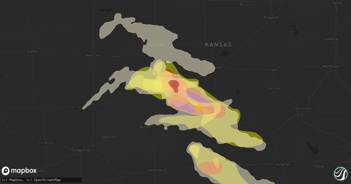
Hail Map in Larned, KS on May 9, 2023
Get this storm
May 9 map
$229
one time, instant access
Download today. No call, no setup
Keep the $229
Bought the map and want the full workflow? Apply the entire $229 to a subscription within 7 days. None of it is wasted.
Every map, not just this one
This buys you this map. Subscription and you get every map we run, in the markets you choose from a few cities to whole states to nationwide. Plus real-time alerts the moment a storm fires.
Contact data
Name, contact info, occupancy, even credit band for addresses in the footprint. You go from where it hit to who to call.
Become the source they trust
Unlimited branding weather history reports on demand. You already have the documented answer ready for the property owner, and you are the one who showed up with it.
Property data and RoofTrace estimates
Pull up any address you have got, its value and the exact code rules for that jurisdiction, straight from One Click Code. Then RoofTrace estimates the squares, pitch, and roof value, priced the way you price.
Storm reports in Larned, KS
Larned, KS
| Date | Description |
|---|---|
| 05/09/20235:05 PM CDT | Reported through social media. |
| 05/09/20234:55 PM CDT | A local report indicates 2.00 inch wind near LARNED |
| 05/09/20234:45 PM CDT | Reported though social media. |
| 05/09/20234:40 PM CDT | A local report indicates 4.00 inch wind near 5 SSE ASH VALLEY |
| 05/09/20234:34 PM CDT | A local report indicates 2.00 inch wind near 5 SE ASH VALLEY |
| 05/09/20234:30 PM CDT | A local report indicates 1.00 inch wind near 5 N LARNED |
| 05/09/20234:20 PM CDT | A local report indicates 2.50 inch wind near 5 ESE ASH VALLEY |
| 05/08/20239:06 PM CDT | A local report indicates 2.00 inch wind near 2 NNE ZOOK |
| 05/08/20237:44 PM CDT | A local report indicates 1.50 inch wind near 5 NNW LARNED |
All States Impacted by Hail Map on May 9, 2023
All Cities Impacted by Hail Map on May 9, 2023
- El Dorado, AR
- Horatio, AR
- De Queen, AR
- Dixon, KY
- Sebree, KY
- Slaughters, KY
- Manitou, KY
- Saint Francis, KS
- McDonald, KS
- Winona, KS
- Monument, KS
- Colby, KS
- Scott City, KS
- Atwood, KS
- Abilene, KS
- Enterprise, KS
- Ludell, KS
- Herndon, KS
- Gem, KS
- Rexford, KS
- Selden, KS
- Oberlin, KS
- Hoxie, KS
- Beaver City, NE
- Oxford, NE
- Edison, NE
- Arapahoe, NE
- Orleans, NE
- Hendley, NE
- Jennings, KS
- Dresden, KS
- Stamford, NE
- Norcatur, KS
- Alma, NE
- Norton, KS
- Lenora, KS
- Almena, KS
- Prairie View, KS
- Long Island, KS
- Phillipsburg, KS
- Republican City, NE
- Hill City, KS
- Logan, KS
- Naponee, NE
- Bloomington, NE
- Kensington, KS
- Agra, KS
- Kirwin, KS
- Glade, KS
- Riverton, NE
- Franklin, NE
- Smith Center, KS
- Gaylord, KS
- Cedar, KS
- Athol, KS
- Portis, KS
- Osborne, KS
- Alton, KS
- Stockton, KS
- Woodston, KS
- Bogue, KS
- Damar, KS
- Palco, KS
- Plainville, KS
- Mankato, KS
- Lebanon, KS
- Downs, KS
- Webber, KS
- Esbon, KS
- Cawker City, KS
- Glen Elder, KS
- Natoma, KS
- Tipton, KS
- Beloit, KS
- Randall, KS
- Jewell, KS
- Ellis, KS
- Catharine, KS
- Victoria, KS
- Paradise, KS
- Formoso, KS
- Waldo, KS
- Russell, KS
- Luray, KS
- Norway, KS
- Courtland, KS
- Jamestown, KS
- Concordia, KS
- Simpson, KS
- Glasco, KS
- Lucas, KS
- Scandia, KS
- Delphos, KS
- Miltonvale, KS
- Aurora, KS
- Clyde, KS
- Minneapolis, KS
- Clay Center, KS
- Bunker Hill, KS
- Bloomington, TX
- Victoria, TX
- Benkelman, NE
- Bird City, KS
- Max, NE
- Stratton, NE
- Bertrand, NE
- Trenton, NE
- Paxton, NE
- Chapman, KS
- Holbrook, NE
- Burr Oak, KS
- New Orleans, LA
- Arnaudville, LA
- Belleville, KS
- Wilsonville, NE
- Lincoln, AL
- Riverside, AL
- Kermit, WV
- Wilsondale, WV
- Crum, WV
- Louise, TX
- Clayton, KS
- Penokee, KS
- Lolita, TX
- Oakley, KS
- Cambridge, NE
- Holdrege, NE
- Hays, KS
- Sylvan Grove, KS
- Clifton, KS
- Morganville, KS
- Longford, KS
- Palmer, KS
- Solomon, KS
- Dorrance, KS
- Bennington, KS
- Talmage, KS
- Green, KS
- Wakefield, KS
- Wilson, KS
- Junction City, KS
- Riley, KS
- Leonardville, KS
- Milford, KS
- Fort Riley, KS
- Woodbine, KS
- Randolph, KS
- Manhattan, KS
- Ogden, KS
- Roopville, GA
- Franklin, GA
- Ellsworth, KS
- Newnan, GA
- Sharpsburg, GA
- Peachtree City, GA
- Lorraine, KS
- Herington, KS
- Tampa, KS
- Ramona, KS
- White City, KS
- Gypsum, KS
- Hope, KS
- Alta Vista, KS
- Dwight, KS
- Council Grove, KS
- Springfield, MO
- Republic, MO
- Brookline, MO
- Lost Springs, KS
- Burdick, KS
- Willard, MO
- Saint George, KS
- Alma, KS
- Wilsey, KS
- Lincolnville, KS
- La Crosse, KS
- Bison, KS
- Strong City, KS
- Marion, KS
- Elmdale, KS
- Wamego, KS
- Olsburg, KS
- Pleasant Hope, MO
- Brighton, MO
- Walnut Grove, MO
- Rush Center, KS
- Otis, KS
- Dawson, MN
- Boyd, MN
- Montevideo, MN
- Paxico, KS
- Allen, KS
- McFarland, KS
- Belvue, KS
- Kellyton, AL
- Alexander City, AL
- Jacksons Gap, AL
- Morrisville, MO
- Aldrich, MO
- Selma, NC
- Kenly, NC
- Wilson, NC
- Elm City, NC
- Saint Marys, KS
- Maple Hill, KS
- Eskridge, KS
- Admire, KS
- Cottonwood Falls, KS
- Americus, KS
- Emporia, KS
- Cedar Point, KS
- Olpe, KS
- Matfield Green, KS
- Farmville, NC
- Fountain, NC
- Walstonburg, NC
- Greenville, NC
- Winterville, NC
- Ayden, NC
- Harveyville, KS
- Topeka, KS
- Reading, KS
- Grifton, NC
- Vanceboro, NC
- Grimesland, NC
- Bolivar, MO
- Larned, KS
- Albert, KS
- Great Bend, KS
- Half Way, MO
- Polk, MO
- Taylors, SC
- Greenville, SC
- Greer, SC
- Burlingame, KS
- Osage City, KS
- Ernul, NC
- New Bern, NC
- Louisburg, MO
- Grantsboro, NC
- Cartersville, GA
- Simpsonville, SC
- Auburn, KS
- Neosho Rapids, KS
- Hartford, KS
- Pawnee Rock, KS
- Urbana, MO
- Hermitage, MO
- Buffalo, MO
- Deep Run, NC
- Kinston, NC
- Trenton, NC
- Tuskegee, AL
- Eureka, KS
- Madison, KS
- Hamilton, KS
- Vassar, KS
- Lyndon, KS
- Quenemo, KS
- Overbrook, KS
- Pomona, KS
- Burlington, KS
- Virgil, KS
- Scranton, KS
- Melvern, KS
- Waverly, KS
- Gridley, KS
- Lebo, KS
- Yates Center, KS
- Williamsburg, KS
- Neosho Falls, KS
- Toronto, KS
- Princeton, KS
- Colony, KS
- Garnett, KS
- Ottawa, KS
- Westphalia, KS
- Le Roy, KS
- Richmond, KS
- Welda, KS
- Neal, KS
- Mauldin, SC
- Carbondale, KS
- Baldwin City, KS
- Preston, MO
- Sheldon, MO
- Lamar, MO
- Rome, GA
- Wellsville, KS
- St John, KS
- Gray Court, SC
- Fountain Inn, SC
- Enoree, SC
- La Crosse, VA
- South Hill, VA
- Woodruff, SC
- Bracey, VA
- Laurens, SC
- Baskerville, VA
- Boydton, VA
- Macon, NC
- Warrenton, NC
- Littleton, NC
- Greeley, KS
- Edgerton, KS
- Paola, KS
- Lane, KS
- Rantoul, KS
- Osawatomie, KS
- Moran, KS
- Kincaid, KS
- Norlina, NC
- Jerico Springs, MO
- El Dorado Springs, MO
- Walker, MO
- Harwood, MO
- Calico Rock, AR
- Piedmont, SC
- Nashville, NC
- Rocky Mount, NC
- Pinetops, NC
- Hollister, NC
- Enfield, NC
- Schell City, MO
- Whitakers, NC
- Bronson, KS
- Mapleton, KS
- Centerville, KS
- Parker, KS
- Mound City, KS
- La Cygne, KS
- Fulton, KS
- Blue Mound, KS
- Fontana, KS
- Prescott, KS
- Spring Hill, KS
- Beulah, ND
- Hebron, ND
- Battleboro, NC
- Macclesfield, NC
- Lewiston Woodville, NC
- Windsor, NC
- Hudson, KS
- Rozel, KS
- Macksville, KS
- Pleasanton, KS
- Louisburg, KS
- Uniontown, KS
- Fort Scott, KS
- Redfield, KS
- Stafford, KS
- La Grange, NC
- Goldsboro, NC
- Grenora, ND
- Williston, ND
- Mountain Home, AR
- Montgomery, LA
- Salina, KS
- Millerville, AL
- Clontarf, MN
- Benson, MN
- Gorham, KS
- Cross Timbers, MO
- Zachary, LA
- Pride, LA
- Lincoln, KS
- Roxie, MS
- Morehead City, NC
- Newport, NC
- Taft, TX
- Tibbie, AL
- Deer Park, AL
- Stantonsburg, NC
- Macon, GA
- Jeffersonville, GA
- Danville, GA
- Bushton, KS
- McIntosh, AL
- Realitos, TX
- Pell City, AL
- Talladega, AL
- Aransas Pass, TX
- Ingleside, TX
- Tyrone, GA
- Fayetteville, GA
- Beaufort, NC
- Dadeville, AL
- Dry Branch, GA
- Tuskegee Institute, AL
- Hancock, MN
- Gladys, VA
- Colfax, LA
- Lafayette, AL
- Five Points, AL
- Roanoke, AL
- Goodwater, AL
- Camp Hill, AL
- Hays, MT
- Harlem, MT
- Shields, ND
- Sylacauga, AL
- Walker, KS
- Bois D Arc, MO
- Ash Grove, MO
- Kanopolis, KS
- Chase City, VA
- Woodland, AL
- Cheyenne, WY
- Revere, MN
- Walnut Grove, MN
- Lamberton, MN
- Havelock, NC
- Burns, WY
- Kenbridge, VA
- Victoria, VA
- Lunenburg, VA
- Freer, TX
- Portland, TX
- Corpus Christi, TX
- Wilmington, NC
- Kilgore, TX
- Wedowee, AL
- Bingham Lake, MN
- Windom, MN
- Claflin, KS
- Pearl River, LA
- Perdido, AL
- Watson, MN
- White, GA
- Jonesboro, LA
- Liebenthal, KS
- Nekoma, KS
- McCracken, KS
- El Dorado, KS
- Agenda, KS
- Natchez, MS
- Florien, LA
- Snow Hill, NC
- Many, LA
- Hoisington, KS
- Alpine, AL
- Rockford, AL
- Notasulga, AL
- Lena, LA
- Wagarville, AL
- Lizella, GA
- Shelby, AL
- Minneota, MN
- Clarkfield, MN
- Tescott, KS
- Picayune, MS
- Hampstead, NC
- Childersburg, AL
- Zwolle, LA
- Rayville, LA
- Clever, MO
- Billings, MO
- Garrison, TX
- Tow, TX
- Wadley, AL
- Iuka, KS
- Glen Ullin, ND
- Turon, KS
- Burdett, KS
- Hanston, KS
- Ness City, KS
- Jetmore, KS
- Byers, KS
- Pratt, KS
- Bronaugh, MO
- Liberal, MO
- Amsterdam, MO
- Drexel, MO
- Butler, MO
- Adrian, MO
- Amoret, MO
- Foster, MO
- Hume, MO
- Lewis, KS
- Kinsley, KS
- Garfield, KS
- New Salem, ND
- Hazen, ND
- Chocowinity, NC
- Bath, NC
- Pinetown, NC
- Sawyer, KS
- Charleston, SC
- Mount Pleasant, SC
- North Charleston, SC
- Sullivans Island, SC
- Denver, CO
- Thornton, CO
- Brighton, CO
- Belpre, KS
- Fort Lupton, CO
- Mandan, ND
- Center, ND
- Isabel, KS
- Medicine Lodge, KS
- Commerce City, CO
- Everton, MO
- Nixa, MO
- Ozark, MO
- Bismarck, ND
- Hudson, CO
- George West, TX
- Sandia, TX
- Three Rivers, TX
- Marionville, MO
- Aurora, MO
- Mount Vernon, MO
- Alexander, KS
- Albin, WY
- Meriden, WY
- Bazine, KS
- Windsor, CO
- Eaton, CO
- Severance, CO
- Greeley, CO
- Ault, CO
- Nashville, KS
- Wasta, SD
- Morrill, NE
- Smithwick, SD
- Mitchell, NE
- Selfridge, ND
- Crawford, NE
- Watauga, SD
- Lyman, NE
- McIntosh, SD
- Howes, SD
- Faith, SD
- Harrison, NE
- Owanka, SD
- Flasher, ND
- Oelrichs, SD
- Oral, SD
- Dupree, SD
- Saint Anthony, ND
- Pine Ridge, SD
- Calliham, TX
- Brownell, KS
- Fort Collins, CO
- Timnath, CO
- Ransom, KS
- Henderson, CO
- Orange Grove, TX
- Wiggins, CO
- Harrisburg, NE
- Goddard, KS
- Wichita, KS
- Fort Morgan, CO
- Boulder, CO
- Longmont, CO
- Niwot, CO
- Steele, ND
- Dawson, ND
- Tappen, ND
- Erie, CO
- Lafayette, CO
- Berthoud, CO
- Mead, CO
- Dacono, CO
- Firestone, CO
- Johnstown, CO
- Platteville, CO
- Milliken, CO
- Frederick, CO
- Gering, NE
- Atlantic Beach, NC
- Scottsbluff, NE
- Starbuck, MN
- La Salle, CO
- Kersey, CO
- Garland, KS
- Deerfield, MO
- Richards, MO
- Milo, MO
- Moundville, MO
- Nevada, MO
- Rockville, MO
- Rich Hill, MO
- Lockwood, MO
- Golden City, MO
- Humansville, MO
- Greenfield, MO
- Stockton, MO
- Arcola, MO
- Fair Play, MO
- Dadeville, MO
- Collins, MO
- South Greenfield, MO
- Jasper, MO
- Fair Grove, MO
- Strafford, MO
- Dunnegan, MO
- Miller, MO
- Halltown, MO
- Rogersville, MO
- Gilcrest, CO
- Williamston, NC
- Jamesville, NC
- Ladson, SC
- West Blocton, AL
- Centreville, AL
- Windyville, MO
- Huger, SC
- Collyer, KS
- Quinter, KS
- Driscoll, ND
- Richardton, ND
- Roggen, CO
- Goose Creek, SC
- Ellendale, ND
- Johns Island, SC
- Lansford, ND
- Highlandville, MO
- Chatham, LA
- Coats, KS
- Zenda, KS
- Cunningham, KS
- Spivey, KS
- Washington, NC
- Mountain View, AR
- Duncanville, AL
- Tuscaloosa, AL
- Lyons, CO
- Berthold, ND
- Carpio, ND
- Marathon, TX
- Plevna, KS
- Pierpont, SD
- Andover, SD
- Groton, SD
- Glenburn, ND
- Loveland, CO
- Calhoun, MO
- Clinton, MO
- Menoken, ND
- Sterling, ND
- Waterloo, SC
- Pelzer, SC
- Lagrange, WY
- Windsor, MO
- Solen, ND
- Dodge, ND
- Hillsdale, WY
- Faulkton, SD
- Maben, MS
- Pheba, MS
- Appleton City, MO
- Napoleon, ND
- Hawk Springs, WY
- Elloree, SC
- Santee, SC
- Osceola, MO
- Montrose, MO
- McCalla, AL
- Eutawville, SC
- Runge, TX
- Pine Bluffs, WY
- Oronogo, MO
- Medina, ND
- Tarboro, NC
- Mountainburg, AR
- La Russell, MO
- Lumpkin, GA
- Sarcoxie, MO
- Fort Stockton, TX
- Tilden, TX
- Clayton, AL
- Alice, TX
- Roseglen, ND
- Ryder, ND
- Reeds, MO
- Carthage, MO
- Merino, CO
- Mathis, TX
- Brent, AL
- Silver Creek, GA
- Flaxton, ND
- Arlington, KS
- Cottondale, AL
- Mize, MS
- Taylorsville, MS
- Castalia, NC
- Wakeeney, KS
- Helena, AL
- Montevallo, AL
- Brierfield, AL
- Regan, ND
- Lowry City, MO
- Brooksville, MS
- McDavid, FL
- Century, FL
- Kenedy, TX
- Aiken, SC
- Garrison, ND
- Cordesville, SC
- Arcadia, KS
- Beeville, TX
- Abbyville, KS
- Refugio, TX
- Charleston Afb, SC
- Palacios, TX
- Port Lavaca, TX
- Birmingham, AL
- Goliad, TX
- Wing, ND
- Pfeifer, KS
- Walnut, KS
- Cove City, NC
- Bushnell, NE
- Keysville, VA
- Greenville, AL
- Portal, ND
- Bowman, SC
- Stark, KS
- Crane, MO
- Galena, MO
- Zapata, TX
- New Brockton, AL
- Awendaw, SC
- Howard, KS
- Cape Fair, MO
- Northport, AL
- Alabaster, AL
- Bessemer, AL
- Utica, KS
- Easley, SC
- Flemington, MO
- Wheatland, MO
- Atmore, AL
- Humboldt, KS
- Iola, KS
- Rutledge, AL
- Stokes, NC
- Arapahoe, NC
- Bethel, NC
- Plain Dealing, LA
- Dix, NE
- Kimball, NE
- Mapleton, ND
- Tuttle, ND
- Oconto, NE
- Callaway, NE
- Woodworth, ND
- Cleveland, ND
- Jamestown, ND
- Evansville, MN
- Fullerton, ND
- Gothenburg, NE
- Gill, CO
- Galeton, CO
- Briggsdale, CO
- Lodgepole, NE
- Winslow, AR
- Halliday, ND
- Sidney, NE
- Crook, CO
- Moncks Corner, SC
- Cameron, SC
- Evans, CO
- Wyndmere, ND
- Milnor, ND
- Bay City, TX
- Brookneal, VA
- Blessing, TX
- Plaza, ND
- Sterling, CO
- Matagorda, TX
- Placedo, TX
- Holly Hill, SC
- Grover, CO
- Verona, MO
- Robinson, ND
- Rockport, TX
- Sabin, MN
- Barnesville, MN
- Port O'Connor, TX
- Tivoli, TX


