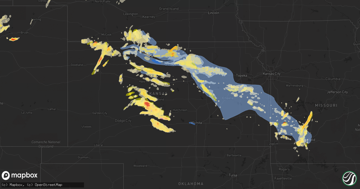
Hail Map in Kansas on May 9, 2023
Get this storm
May 9 map
$229
one time, instant access
Download today. No call, no setup
Keep the $229
Bought the map and want the full workflow? Apply the entire $229 to a subscription within 7 days. None of it is wasted.
Every map, not just this one
This buys you this map. Subscription and you get every map we run, in the markets you choose from a few cities to whole states to nationwide. Plus real-time alerts the moment a storm fires.
Contact data
Name, contact info, occupancy, even credit band for addresses in the footprint. You go from where it hit to who to call.
Become the source they trust
Unlimited branding weather history reports on demand. You already have the documented answer ready for the property owner, and you are the one who showed up with it.
Property data and RoofTrace estimates
Pull up any address you have got, its value and the exact code rules for that jurisdiction, straight from One Click Code. Then RoofTrace estimates the squares, pitch, and roof value, priced the way you price.
Storm reports in Kansas
Kansas
| Date | Description |
|---|---|
| 05/09/20236:59 PM CDT | The hail was pea size to quarter size. |
| 05/09/20236:53 PM CDT | Pea to quarter size hail was reported through social media. |
| 05/09/20236:50 PM CDT | Tree down with powerlines down in the 100 block of west jefferson in pittsburg. |
| 05/09/20236:44 PM CDT | Report from mping: half dollar |
| 05/09/20236:40 PM CDT | Large tree limb down on house in girard. |
| 05/09/20236:35 PM CDT | A local report indicates 60 MPH wind near 3 S PRATT |
| 05/09/20236:30 PM CDT | The hail was quarter to golf ball size. |
| 05/09/20236:27 PM CDT | Report of wind gusts of 60 to 65 mph in the town the of chautauqua. |
| 05/09/20236:24 PM CDT | A local report indicates 58 MPH wind near 3 ENE DODGE CITY |
| 05/09/20236:07 PM CDT | Reported though social media. |
| 05/09/20236:06 PM CDT | Reported through social media. |
| 05/09/20235:54 PM CDT | 50 to 60 mph winds. |
| 05/09/20235:51 PM CDT | A local report indicates 2.00 inch wind near 5 N SAINT JOHN |
| 05/09/20235:50 PM CDT | Ks mesonet station at uniontown ks. |
| 05/09/20235:42 PM CDT | A local report indicates 1.50 inch wind near 2 W OSAWATOMIE |
| 05/09/20235:30 PM CDT | A local report indicates 65 MPH wind near PARKER |
| 05/09/20235:26 PM CDT | A local report indicates 60 MPH wind near OSAWATOMIE |
| 05/09/20235:19 PM CDT | Public reports to 911 of tree fell on house 400th block and 15th street north wichita. No injuries reported. |
| 05/09/20235:15 PM CDT | Report of 60+ mph winds reported by cl203. |
| 05/09/20235:15 PM CDT | Delayed report. |
| 05/09/20235:14 PM CDT | A local report indicates 70 MPH wind near 6 SE OVERBROOK |
| 05/09/20235:10 PM CDT | A local report indicates 60 MPH wind near 5 E SEVERY |
| 05/09/20235:05 PM CDT | Reported through social media. |
| 05/09/20234:55 PM CDT | A local report indicates 2.00 inch wind near LARNED |
| 05/09/20234:47 PM CDT | Tree damage reported with wind gusts. |
| 05/09/20234:47 PM CDT | Trees blown onto houses in the 1300 block n forest and 400 block n erie. Person trapped on second floor of house with rescue in progress. |
| 05/09/20234:46 PM CDT | Minor tree damage and numerous 3-4 inch diameter limbs down. Delayed report. |
| 05/09/20234:45 PM CDT | Reported though social media. |
| 05/09/20234:42 PM CDT | Large trees knocked down and snapped in half. |
| 05/09/20234:40 PM CDT | A local report indicates 4.00 inch wind near 5 SSE ASH VALLEY |
| 05/09/20234:38 PM CDT | Spotter id: bt124. |
| 05/09/20234:35 PM CDT | Measured at the eureka airport. Strong outflow out ahead of the line. |
| 05/09/20234:34 PM CDT | A local report indicates 2.00 inch wind near 5 SE ASH VALLEY |
| 05/09/20234:34 PM CDT | A local report indicates 60 MPH wind near 5 SSE SCRANTON |
| 05/09/20234:30 PM CDT | A local report indicates 1.00 inch wind near 5 N LARNED |
| 05/09/20234:25 PM CDT | Corrects time from previous report. Public report to dispatch of a tree fell that on a house in the 400th block and 15th street. No injuries reported. Time is estimated |
| 05/09/20234:24 PM CDT | Three-inch live tree limbs blown down. Time estimated from radar data. Delayed report. |
| 05/09/20234:24 PM CDT | A local report indicates 60 MPH wind near 4 SW HAMILTON |
| 05/09/20234:20 PM CDT | Unconfirmed report to 911 that power lines are down around the 2300 block s victoria... Wichita. Lines were down on a yard. Delayed report. |
| 05/09/20234:20 PM CDT | A local report indicates 2.50 inch wind near 5 ESE ASH VALLEY |
| 05/09/20234:12 PM CDT | A local report indicates 65 MPH wind near 4 NW LEBO |
| 05/09/20234:10 PM CDT | Large tree branch down on a truck and 2 houses in el dorado. Both houses have damage to them. Delayed report via twitter picture. |
| 05/09/20234:10 PM CDT | 11 inch limb blown down. |
| 05/09/20234:03 PM CDT | A local report indicates 1.00 inch wind near OSAGE CITY |
| 05/09/20233:52 PM CDT | Estimated wind gusts 50-60 mph. Time estimated. |
| 05/09/20233:48 PM CDT | Powerlines were reported down. |
| 05/09/20233:41 PM CDT | 1 inch hail reported outside of allen. |
| 05/09/20233:25 PM CDT | A local report indicates 1.00 inch wind near ELMDALE |
| 05/09/20233:22 PM CDT | Relayed through social media. |
| 05/09/20233:15 PM CDT | A local report indicates 1.00 inch wind near 1 ESE BISON |
| 05/09/20233:15 PM CDT | Delayed report. |
| 05/09/20233:12 PM CDT | Trained spotter estimated 50 to 60 mph winds with pea sized hail. |
| 05/09/20233:00 PM CDT | A local report indicates 1.50 inch wind near 4 NW BISON |
| 05/09/20233:00 PM CDT | Vehicle-mounted anemometer measured 55 to 60 mph winds. Delayed report. |
| 05/09/20232:57 PM CDT | A local report indicates 1.25 inch wind near 3 ENE LA CROSSE |
| 05/09/20232:52 PM CDT | Wind gusts of 70 to 75 reported as well. |
| 05/09/20232:52 PM CDT | Winds ranged from 70 to 75 mph on vehicle anemometer. Quarter sized hail reported too. |
| 05/09/20232:52 PM CDT | Winds ranged from 70 to 75 mph on vehicle anemometer. |
| 05/09/20232:52 PM CDT | Wind gusts of 70 to 75 reported as well. |
| 05/09/20232:50 PM CDT | Hail ranged from pea-size to 1 inch. |
| 05/09/20232:43 PM CDT | A local report indicates 1.00 inch wind near HERINGTON |
| 05/09/20232:32 PM CDT | Dk 101 reported hail up to quarters in diameter. |
| 05/09/20232:30 PM CDT | A local report indicates 1.00 inch wind near HOPE |
| 05/09/20232:22 PM CDT | Spotter used calibrated wind anemometer and measured winds gust ranging from 70 to max 75mph. |
| 05/09/20232:17 PM CDT | A local report indicates 60 MPH wind near FORT RILEY |
| 05/09/20232:15 PM CDT | A local report indicates 1.00 inch wind near 7 ENE LORRAINE |
| 05/09/20232:10 PM CDT | Large tree with trunk about 18 to 24 inches in diameter snapped off. |
| 05/09/20232:05 PM CDT | A local report indicates 76 MPH wind near 2 SE MILFORD |
| 05/09/20232:01 PM CDT | No reported damage. |
| 05/09/20232:00 PM CDT | Spotter estimating 60-65 mph wind gusts. |
| 05/09/20231:57 PM CDT | A local report indicates 1.00 inch wind near 1 W ABILENE |
| 05/09/20231:57 PM CDT | A local report indicates 1.00 inch wind near 4 SSW ABILENE |
| 05/09/20231:30 PM CDT | Spotter estimated winds about 60-65 mph winds. Time estimated. |
| 05/09/20231:30 PM CDT | Spotter estimated winds about 60-65 mph winds. Time estimated. |
| 05/09/20231:25 PM CDT | Brief quarter sized hail via twitter video. |
| 05/09/20231:14 PM CDT | Reported structural damage at the fairgrounds... Damage to a building off hwy 81... And damage to 2-3 inch tree limbs. |
| 05/09/20231:14 PM CDT | A local report indicates 76 MPH wind near 2 SSE CONCORDIA |
| 05/09/20231:07 PM CDT | Trained spotter reported a brief tornado 5 miles south/southwest of miltonvale... Quarter-sized hail and 60 mph wind gusts. |
| 05/09/20231:07 PM CDT | A local report indicates 1.00 inch wind near 3 SW MILTONVALE |
| 05/09/202312:55 PM CDT | Delayed report. Six inch healthy tree limbs torn off trees. |
| 05/09/202312:45 PM CDT | A local report indicates 1.00 inch wind near 9 NNE GLASCO |
| 05/09/202312:35 PM CDT | Reported just west of glasco. |
| 05/09/202312:34 PM CDT | A local report indicates 1.00 inch wind near 2 S SIMPSON |
| 05/09/202312:30 PM CDT | A local report indicates 1.50 inch wind near LURAY |
| 05/09/202312:30 PM CDT | A local report indicates 1.50 inch wind near LURAY |
| 05/09/202312:22 PM CDT | A local report indicates 1.50 inch wind near WALDO |
| 05/09/202312:20 PM CDT | Davis weatherlink station. Time estimated from radar. |
| 05/09/202312:16 PM CDT | Report via mping. |
| 05/09/202312:16 PM CDT | Report via mping. |
| 05/09/202312:16 PM CDT | Report from mping: half dollar |
| 05/09/202312:05 PM CDT | Report via facebook... Time est. From radar. |
| 05/09/202312:03 PM CDT | 2 inch diameter limbs down. |
| 05/09/202312:02 PM CDT | A local report indicates 65 MPH wind near 5 W PARADISE |
| 05/09/202312:01 PM CDT | Quarters with hail covering the ground. Hail lasted about 7 min. |
| 05/09/202311:59 AM CDT | Ksu mesonet site wsw of beloit. |
| 05/09/202311:50 AM CDT | Ambient weather station - cawker weather. |
| 05/09/202311:50 AM CDT | A local report indicates 66 MPH wind near 2 N CAWKER CITY |
| 05/09/202311:42 AM CDT | A local report indicates 1.00 inch wind near 1 NE CODELL |
| 05/09/202311:29 AM CDT | A local report indicates 58 MPH wind near 2 N CAWKER CITY |
| 05/09/202311:22 AM CDT | A local report indicates 81 MPH wind near 1 NNW OSBORNE |
| 05/09/202311:22 AM CDT | Received report from kake of possible damage on the nnw side of osborne near hospital... Confirmed with county dispatch that 3 power poles were broken in that area. Rep |
| 05/09/202311:18 AM CDT | Quarter size hail reported 5n of plainville on hwy 183... Relayed via county dispatch. |
| 05/09/202311:12 AM CDT | Quarter size hail at hwy 18 and 14 rd... Relayed via county dispatch. |
| 05/09/202310:58 AM CDT | Report via spotter network. |
| 05/09/202310:55 AM CDT | Quarter to half dollar size hail reported. |
| 05/09/202310:55 AM CDT | A local report indicates 59 MPH wind near SMITH CENTER AIRPORT |
| 05/09/202310:53 AM CDT | Hail up to tennis ball size reported on the northeast side of mankato. |
| 05/09/20239:23 AM CDT | Delayed report via social media. 42 foot grain trailer moved about 100 feet and blown onto its side. |
| 05/09/20239:20 AM CDT | Trained spotter estimated winds around 65 mph. |
| 05/09/20239:20 AM CDT | Social media report of a wind gusts as the storm moved in around 60 mph. |
| 05/09/20238:55 AM CDT | Hail ranging from pea to golf ball sized with picture of hail covering the ground. |
| 05/09/20238:50 AM CDT | Social media report with picture of ping pong ball sized hail. |
| 05/09/20238:47 AM CDT | Social media report with picture and video of hail around half dollar in size. |
| 05/09/20238:45 AM CDT | Social media report of golf ball sized hail. |
| 05/09/20238:25 AM CDT | Hail up to slightly larger than 1 inch. Lasted 5 minutes. |
| 05/09/20238:20 AM CDT | Social media report with picture of quarter sized hail. |
| 05/09/20238:10 AM CDT | Relayed report of ping pong ball sized hail in menlo. |
| 05/09/20238:00 AM CDT | Relayed via dispatch. Hail ranged from nickel to quarter in size. |
| 05/09/20238:00 AM CDT | A local report indicates 1.00 inch wind near 4 SSW ABILENE |
| 05/09/20237:38 AM CDT | Late report. Found picture on local media website. |
| 05/09/20237:35 AM CDT | Social media report of hail from quarter to golf ball in size with pictures. Hail started around 1230z. |
| 05/09/20237:35 AM CDT | A local report indicates 1.25 inch wind near ENTERPRISE |
| 05/09/20237:30 AM CDT | Estimated dime to nickel sized hail between 7:30 and 8 am ct. The hail turned the ground white. Estimated time of report. |
| 05/08/202310:25 PM CDT | A local report indicates 62 MPH wind near WICHITA EISENHOWER AIR |
| 05/08/202310:24 PM CDT | Nws storm survey revealed snapped branches off of a bradford pear tree and damage to another tree. Time is based on nearby airport observation. |
| 05/08/20239:06 PM CDT | A local report indicates 2.00 inch wind near 2 NNE ZOOK |
| 05/08/20238:30 PM CDT | Photo on social media. |
| 05/08/20238:29 PM CDT | A local report indicates 1.50 inch wind near 2 E NASHVILLE |
| 05/08/20238:25 PM CDT | Photo on social media. |
| 05/08/20238:25 PM CDT | A local report indicates 1.25 inch wind near 3 S BAZINE |
| 05/08/20238:16 PM CDT | A local report indicates 1.00 inch wind near BAZINE |
| 05/08/20238:10 PM CDT | Accumulating hail. Dimes to quarters. |
| 05/08/20238:04 PM CDT | A local report indicates 1.25 inch wind near ROZEL |
| 05/08/20237:50 PM CDT | A local report indicates 1.00 inch wind near 5 SE PRATT |
| 05/08/20237:49 PM CDT | Reported by social media. |
| 05/08/20237:44 PM CDT | A local report indicates 1.50 inch wind near 5 NNW LARNED |
| 05/08/20237:43 PM CDT | A local report indicates 1.50 inch wind near PRATT |
| 05/08/20237:38 PM CDT | A local report indicates 1.00 inch wind near 4 NNE BURDETT |
| 05/08/20237:35 PM CDT | A tree took down a power line when it fell. The report is via social media. |
| 05/08/20237:30 PM CDT | This report is from a davis system. Dv100392. The time was based on radar. |
| 05/08/20237:26 PM CDT | This report was via social media. |
| 05/08/20237:24 PM CDT | A local report indicates 2.00 inch wind near TURON |
| 05/08/20237:20 PM CDT | A local report indicates 1.50 inch wind near TURON |
| 05/08/20237:00 PM CDT | A local report indicates 1.00 inch wind near 1 N KINSLEY |
| 05/08/20237:00 PM CDT | Reported by social media. |
All States Impacted by Hail Map on May 9, 2023
Cities Impacted by Hail Map on May 9, 2023
- El Dorado, AR
- Horatio, AR
- De Queen, AR
- Dixon, KY
- Sebree, KY
- Slaughters, KY
- Manitou, KY
- Saint Francis, KS
- McDonald, KS
- Winona, KS
- Monument, KS
- Colby, KS
- Scott City, KS
- Atwood, KS
- Abilene, KS
- Enterprise, KS
- Ludell, KS
- Herndon, KS
- Gem, KS
- Rexford, KS
- Selden, KS
- Oberlin, KS
- Hoxie, KS
- Beaver City, NE
- Oxford, NE
- Edison, NE
- Arapahoe, NE
- Orleans, NE
- Hendley, NE
- Jennings, KS
- Dresden, KS
- Stamford, NE
- Norcatur, KS
- Alma, NE
- Norton, KS
- Lenora, KS
- Almena, KS
- Prairie View, KS
- Long Island, KS
- Phillipsburg, KS
- Republican City, NE
- Hill City, KS
- Logan, KS
- Naponee, NE
- Bloomington, NE
- Kensington, KS
- Agra, KS
- Kirwin, KS
- Glade, KS
- Riverton, NE
- Franklin, NE
- Smith Center, KS
- Gaylord, KS
- Cedar, KS
- Athol, KS
- Portis, KS
- Osborne, KS
- Alton, KS
- Stockton, KS
- Woodston, KS
- Bogue, KS
- Damar, KS
- Palco, KS
- Plainville, KS
- Mankato, KS
- Lebanon, KS
- Downs, KS
- Webber, KS
- Esbon, KS
- Cawker City, KS
- Glen Elder, KS
- Natoma, KS
- Tipton, KS
- Beloit, KS
- Randall, KS
- Jewell, KS
- Ellis, KS
- Catharine, KS
- Victoria, KS
- Paradise, KS
- Formoso, KS
- Waldo, KS
- Russell, KS
- Luray, KS
- Norway, KS
- Courtland, KS
- Jamestown, KS
- Concordia, KS
- Simpson, KS
- Glasco, KS
- Lucas, KS
- Scandia, KS
- Delphos, KS
- Miltonvale, KS
- Aurora, KS
- Clyde, KS
- Minneapolis, KS
- Clay Center, KS
- Bunker Hill, KS
- Bloomington, TX
- Victoria, TX
- Benkelman, NE
- Bird City, KS
- Max, NE
- Stratton, NE
- Bertrand, NE
- Trenton, NE
- Paxton, NE
- Chapman, KS
- Holbrook, NE
- Burr Oak, KS
- New Orleans, LA
- Arnaudville, LA
- Belleville, KS
- Wilsonville, NE
- Lincoln, AL
- Riverside, AL
- Kermit, WV
- Wilsondale, WV
- Crum, WV
- Louise, TX
- Clayton, KS
- Penokee, KS
- Lolita, TX
- Oakley, KS
- Cambridge, NE
- Holdrege, NE
- Hays, KS
- Sylvan Grove, KS
- Clifton, KS
- Morganville, KS
- Longford, KS
- Palmer, KS
- Solomon, KS
- Dorrance, KS
- Bennington, KS
- Talmage, KS
- Green, KS
- Wakefield, KS
- Wilson, KS
- Junction City, KS
- Riley, KS
- Leonardville, KS
- Milford, KS
- Fort Riley, KS
- Woodbine, KS
- Randolph, KS
- Manhattan, KS
- Ogden, KS
- Roopville, GA
- Franklin, GA
- Ellsworth, KS
- Newnan, GA
- Sharpsburg, GA
- Peachtree City, GA
- Lorraine, KS
- Herington, KS
- Tampa, KS
- Ramona, KS
- White City, KS
- Gypsum, KS
- Hope, KS
- Alta Vista, KS
- Dwight, KS
- Council Grove, KS
- Springfield, MO
- Republic, MO
- Brookline, MO
- Lost Springs, KS
- Burdick, KS
- Willard, MO
- Saint George, KS
- Alma, KS
- Wilsey, KS
- Lincolnville, KS
- La Crosse, KS
- Bison, KS
- Strong City, KS
- Marion, KS
- Elmdale, KS
- Wamego, KS
- Olsburg, KS
- Pleasant Hope, MO
- Brighton, MO
- Walnut Grove, MO
- Rush Center, KS
- Otis, KS
- Dawson, MN
- Boyd, MN
- Montevideo, MN
- Paxico, KS
- Allen, KS
- McFarland, KS
- Belvue, KS
- Kellyton, AL
- Alexander City, AL
- Jacksons Gap, AL
- Morrisville, MO
- Aldrich, MO
- Selma, NC
- Kenly, NC
- Wilson, NC
- Elm City, NC
- Saint Marys, KS
- Maple Hill, KS
- Eskridge, KS
- Admire, KS
- Cottonwood Falls, KS
- Americus, KS
- Emporia, KS
- Cedar Point, KS
- Olpe, KS
- Matfield Green, KS
- Farmville, NC
- Fountain, NC
- Walstonburg, NC
- Greenville, NC
- Winterville, NC
- Ayden, NC
- Harveyville, KS
- Topeka, KS
- Reading, KS
- Grifton, NC
- Vanceboro, NC
- Grimesland, NC
- Bolivar, MO
- Larned, KS
- Albert, KS
- Great Bend, KS
- Half Way, MO
- Polk, MO
- Taylors, SC
- Greenville, SC
- Greer, SC
- Burlingame, KS
- Osage City, KS
- Ernul, NC
- New Bern, NC
- Louisburg, MO
- Grantsboro, NC
- Cartersville, GA
- Simpsonville, SC
- Auburn, KS
- Neosho Rapids, KS
- Hartford, KS
- Pawnee Rock, KS
- Urbana, MO
- Hermitage, MO
- Buffalo, MO
- Deep Run, NC
- Kinston, NC
- Trenton, NC
- Tuskegee, AL
- Eureka, KS
- Madison, KS
- Hamilton, KS
- Vassar, KS
- Lyndon, KS
- Quenemo, KS
- Overbrook, KS
- Pomona, KS
- Burlington, KS
- Virgil, KS
- Scranton, KS
- Melvern, KS
- Waverly, KS
- Gridley, KS
- Lebo, KS
- Yates Center, KS
- Williamsburg, KS
- Neosho Falls, KS
- Toronto, KS
- Princeton, KS
- Colony, KS
- Garnett, KS
- Ottawa, KS
- Westphalia, KS
- Le Roy, KS
- Richmond, KS
- Welda, KS
- Neal, KS
- Mauldin, SC
- Carbondale, KS
- Baldwin City, KS
- Preston, MO
- Sheldon, MO
- Lamar, MO
- Rome, GA
- Wellsville, KS
- St John, KS
- Gray Court, SC
- Fountain Inn, SC
- Enoree, SC
- La Crosse, VA
- South Hill, VA
- Woodruff, SC
- Bracey, VA
- Laurens, SC
- Baskerville, VA
- Boydton, VA
- Macon, NC
- Warrenton, NC
- Littleton, NC
- Greeley, KS
- Edgerton, KS
- Paola, KS
- Lane, KS
- Rantoul, KS
- Osawatomie, KS
- Moran, KS
- Kincaid, KS
- Norlina, NC
- Jerico Springs, MO
- El Dorado Springs, MO
- Walker, MO
- Harwood, MO
- Calico Rock, AR
- Piedmont, SC
- Nashville, NC
- Rocky Mount, NC
- Pinetops, NC
- Hollister, NC
- Enfield, NC
- Schell City, MO
- Whitakers, NC
- Bronson, KS
- Mapleton, KS
- Centerville, KS
- Parker, KS
- Mound City, KS
- La Cygne, KS
- Fulton, KS
- Blue Mound, KS
- Fontana, KS
- Prescott, KS
- Spring Hill, KS
- Beulah, ND
- Hebron, ND
- Battleboro, NC
- Macclesfield, NC
- Lewiston Woodville, NC
- Windsor, NC
- Hudson, KS
- Rozel, KS
- Macksville, KS
- Pleasanton, KS
- Louisburg, KS
- Uniontown, KS
- Fort Scott, KS
- Redfield, KS
- Stafford, KS
- La Grange, NC
- Goldsboro, NC
- Grenora, ND
- Williston, ND
- Mountain Home, AR
- Montgomery, LA
- Salina, KS
- Millerville, AL
- Clontarf, MN
- Benson, MN
- Gorham, KS
- Cross Timbers, MO
- Zachary, LA
- Pride, LA
- Lincoln, KS
- Roxie, MS
- Morehead City, NC
- Newport, NC
- Taft, TX
- Tibbie, AL
- Deer Park, AL
- Stantonsburg, NC
- Macon, GA
- Jeffersonville, GA
- Danville, GA
- Bushton, KS
- McIntosh, AL
- Realitos, TX
- Pell City, AL
- Talladega, AL
- Aransas Pass, TX
- Ingleside, TX
- Tyrone, GA
- Fayetteville, GA
- Beaufort, NC
- Dadeville, AL
- Dry Branch, GA
- Tuskegee Institute, AL
- Hancock, MN
- Gladys, VA
- Colfax, LA
- Lafayette, AL
- Five Points, AL
- Roanoke, AL
- Goodwater, AL
- Camp Hill, AL
- Hays, MT
- Harlem, MT
- Shields, ND
- Sylacauga, AL
- Walker, KS
- Bois D Arc, MO
- Ash Grove, MO
- Kanopolis, KS
- Chase City, VA
- Woodland, AL
- Cheyenne, WY
- Revere, MN
- Walnut Grove, MN
- Lamberton, MN
- Havelock, NC
- Burns, WY
- Kenbridge, VA
- Victoria, VA
- Lunenburg, VA
- Freer, TX
- Portland, TX
- Corpus Christi, TX
- Wilmington, NC
- Kilgore, TX
- Wedowee, AL
- Bingham Lake, MN
- Windom, MN
- Claflin, KS
- Pearl River, LA
- Perdido, AL
- Watson, MN
- White, GA
- Jonesboro, LA
- Liebenthal, KS
- Nekoma, KS
- McCracken, KS
- El Dorado, KS
- Agenda, KS
- Natchez, MS
- Florien, LA
- Snow Hill, NC
- Many, LA
- Hoisington, KS
- Alpine, AL
- Rockford, AL
- Notasulga, AL
- Lena, LA
- Wagarville, AL
- Lizella, GA
- Shelby, AL
- Minneota, MN
- Clarkfield, MN
- Tescott, KS
- Picayune, MS
- Hampstead, NC
- Childersburg, AL
- Zwolle, LA
- Rayville, LA
- Clever, MO
- Billings, MO
- Garrison, TX
- Tow, TX
- Wadley, AL
- Iuka, KS
- Glen Ullin, ND
- Turon, KS
- Burdett, KS
- Hanston, KS
- Ness City, KS
- Jetmore, KS
- Byers, KS
- Pratt, KS
- Bronaugh, MO
- Liberal, MO
- Amsterdam, MO
- Drexel, MO
- Butler, MO
- Adrian, MO
- Amoret, MO
- Foster, MO
- Hume, MO
- Lewis, KS
- Kinsley, KS
- Garfield, KS
- New Salem, ND
- Hazen, ND
- Chocowinity, NC
- Bath, NC
- Pinetown, NC
- Sawyer, KS
- Charleston, SC
- Mount Pleasant, SC
- North Charleston, SC
- Sullivans Island, SC
- Denver, CO
- Thornton, CO
- Brighton, CO
- Belpre, KS
- Fort Lupton, CO
- Mandan, ND
- Center, ND
- Isabel, KS
- Medicine Lodge, KS
- Commerce City, CO
- Everton, MO
- Nixa, MO
- Ozark, MO
- Bismarck, ND
- Hudson, CO
- George West, TX
- Sandia, TX
- Three Rivers, TX
- Marionville, MO
- Aurora, MO
- Mount Vernon, MO
- Alexander, KS
- Albin, WY
- Meriden, WY
- Bazine, KS
- Windsor, CO
- Eaton, CO
- Severance, CO
- Greeley, CO
- Ault, CO
- Nashville, KS
- Wasta, SD
- Morrill, NE
- Smithwick, SD
- Mitchell, NE
- Selfridge, ND
- Crawford, NE
- Watauga, SD
- Lyman, NE
- McIntosh, SD
- Howes, SD
- Faith, SD
- Harrison, NE
- Owanka, SD
- Flasher, ND
- Oelrichs, SD
- Oral, SD
- Dupree, SD
- Saint Anthony, ND
- Pine Ridge, SD
- Calliham, TX
- Brownell, KS
- Fort Collins, CO
- Timnath, CO
- Ransom, KS
- Henderson, CO
- Orange Grove, TX
- Wiggins, CO
- Harrisburg, NE
- Goddard, KS
- Wichita, KS
- Fort Morgan, CO
- Boulder, CO
- Longmont, CO
- Niwot, CO
- Steele, ND
- Dawson, ND
- Tappen, ND
- Erie, CO
- Lafayette, CO
- Berthoud, CO
- Mead, CO
- Dacono, CO
- Firestone, CO
- Johnstown, CO
- Platteville, CO
- Milliken, CO
- Frederick, CO
- Gering, NE
- Atlantic Beach, NC
- Scottsbluff, NE
- Starbuck, MN
- La Salle, CO
- Kersey, CO
- Garland, KS
- Deerfield, MO
- Richards, MO
- Milo, MO
- Moundville, MO
- Nevada, MO
- Rockville, MO
- Rich Hill, MO
- Lockwood, MO
- Golden City, MO
- Humansville, MO
- Greenfield, MO
- Stockton, MO
- Arcola, MO
- Fair Play, MO
- Dadeville, MO
- Collins, MO
- South Greenfield, MO
- Jasper, MO
- Fair Grove, MO
- Strafford, MO
- Dunnegan, MO
- Miller, MO
- Halltown, MO
- Rogersville, MO
- Gilcrest, CO
- Williamston, NC
- Jamesville, NC
- Ladson, SC
- West Blocton, AL
- Centreville, AL
- Windyville, MO
- Huger, SC
- Collyer, KS
- Quinter, KS
- Driscoll, ND
- Richardton, ND
- Roggen, CO
- Goose Creek, SC
- Ellendale, ND
- Johns Island, SC
- Lansford, ND
- Highlandville, MO
- Chatham, LA
- Coats, KS
- Zenda, KS
- Cunningham, KS
- Spivey, KS
- Washington, NC
- Mountain View, AR
- Duncanville, AL
- Tuscaloosa, AL
- Lyons, CO
- Berthold, ND
- Carpio, ND
- Marathon, TX
- Plevna, KS
- Pierpont, SD
- Andover, SD
- Groton, SD
- Glenburn, ND
- Loveland, CO
- Calhoun, MO
- Clinton, MO
- Menoken, ND
- Sterling, ND
- Waterloo, SC
- Pelzer, SC
- Lagrange, WY
- Windsor, MO
- Solen, ND
- Dodge, ND
- Hillsdale, WY
- Faulkton, SD
- Maben, MS
- Pheba, MS
- Appleton City, MO
- Napoleon, ND
- Hawk Springs, WY
- Elloree, SC
- Santee, SC
- Osceola, MO
- Montrose, MO
- McCalla, AL
- Eutawville, SC
- Runge, TX
- Pine Bluffs, WY
- Oronogo, MO
- Medina, ND
- Tarboro, NC
- Mountainburg, AR
- La Russell, MO
- Lumpkin, GA
- Sarcoxie, MO
- Fort Stockton, TX
- Tilden, TX
- Clayton, AL
- Alice, TX
- Roseglen, ND
- Ryder, ND
- Reeds, MO
- Carthage, MO
- Merino, CO
- Mathis, TX
- Brent, AL
- Silver Creek, GA
- Flaxton, ND
- Arlington, KS
- Cottondale, AL
- Mize, MS
- Taylorsville, MS
- Castalia, NC
- Wakeeney, KS
- Helena, AL
- Montevallo, AL
- Brierfield, AL
- Regan, ND
- Lowry City, MO
- Brooksville, MS
- McDavid, FL
- Century, FL
- Kenedy, TX
- Aiken, SC
- Garrison, ND
- Cordesville, SC
- Arcadia, KS
- Beeville, TX
- Abbyville, KS
- Refugio, TX
- Charleston Afb, SC
- Palacios, TX
- Port Lavaca, TX
- Birmingham, AL
- Goliad, TX
- Wing, ND
- Pfeifer, KS
- Walnut, KS
- Cove City, NC
- Bushnell, NE
- Keysville, VA
- Greenville, AL
- Portal, ND
- Bowman, SC
- Stark, KS
- Crane, MO
- Galena, MO
- Zapata, TX
- New Brockton, AL
- Awendaw, SC
- Howard, KS
- Cape Fair, MO
- Northport, AL
- Alabaster, AL
- Bessemer, AL
- Utica, KS
- Easley, SC
- Flemington, MO
- Wheatland, MO
- Atmore, AL
- Humboldt, KS
- Iola, KS
- Rutledge, AL
- Stokes, NC
- Arapahoe, NC
- Bethel, NC
- Plain Dealing, LA
- Dix, NE
- Kimball, NE
- Mapleton, ND
- Tuttle, ND
- Oconto, NE
- Callaway, NE
- Woodworth, ND
- Cleveland, ND
- Jamestown, ND
- Evansville, MN
- Fullerton, ND
- Gothenburg, NE
- Gill, CO
- Galeton, CO
- Briggsdale, CO
- Lodgepole, NE
- Winslow, AR
- Halliday, ND
- Sidney, NE
- Crook, CO
- Moncks Corner, SC
- Cameron, SC
- Evans, CO
- Wyndmere, ND
- Milnor, ND
- Bay City, TX
- Brookneal, VA
- Blessing, TX
- Plaza, ND
- Sterling, CO
- Matagorda, TX
- Placedo, TX
- Holly Hill, SC
- Grover, CO
- Verona, MO
- Robinson, ND
- Rockport, TX
- Sabin, MN
- Barnesville, MN
- Port O'Connor, TX
- Tivoli, TX


