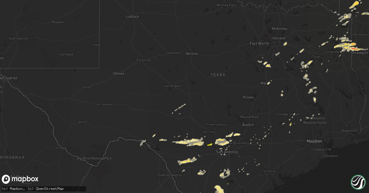
Hail Map in Texas on May 9, 2014
Get this storm
May 9 map
$229
one time, instant access
Download today. No call, no setup
Keep the $229
Bought the map and want the full workflow? Apply the entire $229 to a subscription within 7 days. None of it is wasted.
Every map, not just this one
This buys you this map. Subscription and you get every map we run, in the markets you choose from a few cities to whole states to nationwide. Plus real-time alerts the moment a storm fires.
Contact data
Name, contact info, occupancy, even credit band for addresses in the footprint. You go from where it hit to who to call.
Become the source they trust
Unlimited branding weather history reports on demand. You already have the documented answer ready for the property owner, and you are the one who showed up with it.
Property data and RoofTrace estimates
Pull up any address you have got, its value and the exact code rules for that jurisdiction, straight from One Click Code. Then RoofTrace estimates the squares, pitch, and roof value, priced the way you price.
Storm reports in Texas
Texas
| Date | Description |
|---|---|
| 05/09/20146:50 PM CDT | A local report indicates 1.00 inch wind near HALLSBURG |
| 05/09/20146:42 PM CDT | 5 minutes of nickel to quarter hail near purtis creek state park |
| 05/09/20146:35 PM CDT | Roof of a bakery partially removed and blown onto highway 83. |
| 05/09/20146:20 PM CDT | A local report indicates 1.00 inch wind near REDWATER |
| 05/09/20146:13 PM CDT | A local report indicates 1.25 inch wind near CARL'S CORNER |
| 05/09/20145:56 PM CDT | Quarter sized hail reported by spotter at dps office. |
| 05/09/20145:50 PM CDT | Nickel to quarter at palestine high school |
| 05/09/20145:42 PM CDT | Tractor trailer flipped on mines road in north laredo. |
| 05/09/20145:41 PM CDT | Laredo asos report wind gusts to 66 mph |
| 05/09/20145:40 PM CDT | Nickel to quarter fm 320 and 425 |
| 05/09/20144:46 PM CDT | A local report indicates 1.00 inch wind near 16 NE MARSHALL |
| 05/09/20144:45 PM CDT | Ping pong ball sized hail on the southwest side of karnack along hwy. 43. |
| 05/09/20143:50 PM CDT | Quarter sized hail on highway 105 at the washington grimes county line. |
| 05/09/20143:04 PM CDT | A local report indicates 1.00 inch wind near 13 N HALLSVILLE |
| 05/09/20142:31 PM CDT | Ping pong ball sized hail at fort mckavett state park |
| 05/09/20141:30 PM CDT | Top half of a large healthy pecan tree blown down by thunderstorm wind gusts |
| 05/09/20141:15 PM CDT | 6-8 inch diameter tree down along with multiple full trash cans blown over. |
| 05/09/201412:30 PM CDT | Thunderstorm wind gusts blew the roof off an 80 x 200 foot section of an office building at the continental test track. Winds were observed to be straight line. |
| 05/09/201412:30 PM CDT | Also...wind gusts to e55 mph |
| 05/09/201412:19 PM CDT | A local report indicates 1.00 inch wind near 4 W BERGHEIM |
| 05/09/201410:35 AM CDT | Putting vehicles under carports to protect from large hail |
| 05/09/20149:30 AM CDT | Thunderstorm wind gusts blowing from 50 to 60 mph |
| 05/09/20149:30 AM CDT | Hail coming down hard and fast |
| 05/09/20149:18 AM CDT | Hail covering the ground |
| 05/08/20149:13 PM CDT | Spotter estimates 55 to 60 mph winds in edcouch. |
| 05/08/20148:59 PM CDT | Trees down in lyford. Semi truck blown over at highway 1015 and 186. |
| 05/08/20148:34 PM CDT | Several reports of trees and powerlines downed in mission and sullivan. |
| 05/08/20148:26 PM CDT | Signs blown down on the expressway...highway 83...interstate 2 in palmview. |
| 05/08/20148:10 PM CDT | A local report indicates 1.00 inch wind near NASH |
| 05/08/20148:10 PM CDT | Trees down on hwy 43 and hwy 125 |
| 05/08/20148:10 PM CDT | Several power poles down and power line tangled in trees throughout the city of edinburg. |
| 05/08/20148:00 PM CDT | Large limb off mesquite tree...approximately 130 pounds. |
| 05/08/20147:59 PM CDT | Several power lines downed in falfurrias and in the county on highway 223. Trees down at highway 219 and 206 |
| 05/08/20147:50 PM CDT | A local report indicates 1.00 inch wind near BETTIE |
| 05/08/20147:42 PM CDT | Multiple large tree limbs down on fm 735. |
| 05/08/20147:20 PM CDT | Law enforcement reported a tree in the road on fm 716 west of premont. |
| 05/08/20147:08 PM CDT | Wind damage to trailers and trees in the south fork estates at the intersection of farm to market 3073 and highway 16. |
| 05/08/20147:04 PM CDT | A local report indicates 1.25 inch wind near 3 E ITASCA |
| 05/08/20147:01 PM CDT | Powerlines down over the roadway in hebbronville. |
All States Impacted by Hail Map on May 9, 2014
Cities Impacted by Hail Map on May 9, 2014
- Leakey, TX
- Karnack, TX
- Vivian, LA
- Mooringsport, LA
- Jefferson, TX
- Belcher, LA
- Oil City, LA
- Boerne, TX
- Boonville, IN
- Chandler, IN
- Tennyson, IN
- Mineral Springs, AR
- Saratoga, AR
- Laredo, TX
- Realitos, TX
- Larue, TX
- Salem, MO
- Hebbronville, TX
- Grandview, TX
- Barksdale, TX
- Itasca, TX
- Jackson, MO
- Cape Girardeau, MO
- Grapeland, TX
- Advance, MO
- Gipsy, MO
- McGee, MO
- Sturdivant, MO
- Zalma, MO
- Texarkana, TX
- Marble Hill, MO
- Sedgewickville, MO
- Uvalde, TX
- Quemado, TX
- Brackettville, TX
- Knippa, TX
- Sabinal, TX
- La Pryor, TX
- Ozan, AR
- Lockesburg, AR
- Nashville, AR
- Shreveport, LA
- Gilmer, TX
- Charlotte, TX
- Jourdanton, TX
- Lovelady, TX
- Palmer, TX
- Trinity, TX
- Mineral Point, MO
- Potosi, MO
- Kenedy, TX
- Marshall, TX
- Gentryville, IN
- Evansville, IN
- Lamar, IN
- Saint Meinrad, IN
- Tell City, IN
- Evanston, IN
- Chrisney, IN
- Newburgh, IN
- Santa Claus, IN
- Paige, TX
- Concepcion, TX
- Blanchard, LA
- Tamms, IL
- Thebes, IL
- Olive Branch, IL
- Dilley, TX
- Canton, TX
- New Boston, TX
- Bismarck, AR
- Amity, AR
- Tilden, TX
- Prescott, AR
- Medina, TX
- Utopia, TX
- Tarpley, TX
- Lockhart, TX
- Dale, TX
- Brownwood, MO
- Greenville, MO
- Wappapello, MO
- Oran, MO
- Daingerfield, TX
- Grand Saline, TX
- Vienna, IL
- Buncombe, IL
- Vanderpool, TX
- Navasota, TX
- Mount Vernon, IN
- Mill Spring, MO
- Saint Mary, MO
- Perryville, MO
- Menard, TX
- Alamo, TN
- Mertens, TX
- Bynum, TX
- Hillsboro, TX
- Milford, TX
- Harleton, TX
- Rosston, AR
- Hooks, TX
- Ashdown, AR
- Salem, KY
- Hampton, KY
- Princeton, LA
- Bismarck, IL
- Alvin, IL
- Danville, IL
- West Lebanon, IN
- San Antonio, TX
- Williamsville, MO
- Piedmont, MO
- Ellsinore, MO
- Cotulla, TX
- Fort McKavett, TX
- San Diego, TX
- Freer, TX
- Karnes City, TX
- Gillett, TX
- Zapata, TX
- Guerra, TX
- San Ygnacio, TX
- Camden, IN
- Logansport, IN
- Hammond, LA
- La Center, KY
- Helotes, TX
- Waskom, TX
- Palestine, TX
- Cuero, TX
- Yorktown, TX
- Montgomery, TX
- Covington, TX
- Camp Wood, TX
- Frankston, TX
- Flint, TX
- Chandler, TX
- New Braunfels, TX
- Bulverde, TX
- Homer, IL
- Longview, IL
- Allerton, IL
- Broadlands, IL
- Jonesboro, AR
- Haughton, LA
- Chester, IL
- Ironton, MO
- Fredericktown, MO
- Sainte Genevieve, MO
- Rockwood, IL
- Farmington, MO
- Doe Run, MO
- Jacob, IL
- Jbsa Lackland, TX
- Atascosa, TX
- Kingsville, TX
- Wilson, AR
- Dyess, AR
- Frohna, MO
- Rocksprings, TX
- Hallsville, TX
- Longview, TX
- Bossier City, LA
- Diana, TX
- Concan, TX
- Mabank, TX
- Eustace, TX
- Kemp, TX
- Millersville, MO
- Daisy, MO
- Patton, MO
- Oak Ridge, MO
- New Waverly, TX
- Sonora, TX
- Forney, TX
- Terrell, TX
- Watson, OK
- Cove, AR
- Spring Branch, TX
- Rio Frio, TX
- Peru, IN
- Galveston, IN
- Walton, IN
- Waelder, TX
- Golconda, IL
- Simpson, IL
- Elkhart, TX
- Henderson, KY
- Kendalia, TX
- Rosanky, TX
- Linden, TX
- Dongola, IL
- Jonesboro, IL
- Anna, IL
- Pipe Creek, TX
- Martin, TN
- Bellville, TX
- Pilot Knob, MO
- Bismarck, MO
- Ava, IL
- Middle Brook, MO
- Campbell Hill, IL
- Arcadia, MO
- Park Hills, MO
- Del Rio, TX
- Christine, TX
- Pleasanton, TX
- Maud, TX
- Falls City, TX
- Avinger, TX
- Crockett, TX
- Kennard, TX
- Marion, KY
- Wimberley, TX
- San Marcos, TX
- Villa Ridge, IL
- Pulaski, IL
- Scott City, MO
- Mounds, IL
- Hawkins, TX
- Eldorado, TX
- Waco, TX
- Riesel, TX
- Corsicana, TX
- Brenham, TX
- Washington, TX
- Canyon Lake, TX
- Rattan, OK
- Lesterville, MO
- Black, MO
- Belleview, MO
- Woodburn, IN
- Montalba, TX
- Bremond, TX
- Franklin, TX
- Fischer, TX
- Ogden, AR
- Encinal, TX
- Queen City, TX
- Emmet, AR
- Hope, AR
- De Kalb, TX
- McClure, IL
- Karnak, IL
- Lowndes, MO
- Miller City, IL
- Grand Chain, IL
- Whitewater, MO
- Cairo, IL
- Chaffee, MO
- Olmsted, IL
- Comstock, TX
- Smithville, TX
- Tuscola, IL
- Pesotum, IL
- Elberfeld, IN
- Bandera, TX
- Pittsburg, TX
- Red Rock, TX
- Sharon, TN
- Crystal City, TX
- Clubb, MO
- Slaughters, KY
- Sebree, KY
- Ida, MI
- Petersburg, MI
- Gonzales, TX
- West Point, TX
- Muldoon, TX
- Premont, TX
- Alice, TX
- Halls, TN
- Big Sandy, TX
- Ripley, TN
- Athens, TX
- Coldspring, TX
- Giddings, TX
- Trenton, TN
- Atlanta, TX
- Kenton, TN
- Rives, TN
- Waldron, MI
- Saffell, AR
- Cord, AR
- Powell, TX
- Kerens, TX
- Bivins, TX
- Leopold, IN
- Silva, MO
- Willis, TX
- Encino, TX
- Winona, MO
- Anderson, TX
- Monroe, IN
- Fairmount, IL
- Santa Elena, TX
- Ullin, IL
- Ferris, TX
- Ennis, TX
- Waxahachie, TX
- Texarkana, AR
- Crandall, TX
- Dresden, TN
- Haworth, OK
- Rio Vista, TX
- Blum, TX
- Bonne Terre, MO
- D Hanis, TX
- Perrysville, IN
- Flatonia, TX
- Antwerp, OH
- Westhoff, TX
- La Grange, TX
- Axtell, TX
- Stockdale, TX
- Troup, TX
- Georgetown, IL
- Ridge Farm, IL
- Cushing, TX
- Laneville, TX
- Lone Star, TX
- Smithville, OK
- Louisville, KY
- Delight, AR
- Murfreesboro, AR
- New Concord, KY
- Bergheim, TX
- McCaskill, AR
- Blanco, TX
- Henderson, TX
- Brownsville, TN
- Deerfield, MI
- Blissfield, MI
- Cypress, IL
- Goreville, IL
- Rumsey, KY
- Luling, TX
- Batesville, TX
- Pearsall, TX
- Kosse, TX
- Fulton, AR
- Simms, TX
- College Station, TX
- Plantersville, TX
- Payne, OH
- New Waverly, IN
- Bristow, IN
- Grandview, IN
- Branchville, IN
- Leavenworth, IN
- Cannelton, IN
- Battletown, KY
- Troy, IN


