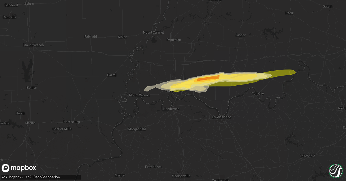
Hail Map in Evansville, IN on May 9, 2014
Get this storm
May 9 map
$229
one time, instant access
Download today. No call, no setup
Keep the $229
Bought the map and want the full workflow? Apply the entire $229 to a subscription within 7 days. None of it is wasted.
Every map, not just this one
This buys you this map. Subscription and you get every map we run, in the markets you choose from a few cities to whole states to nationwide. Plus real-time alerts the moment a storm fires.
Contact data
Name, contact info, occupancy, even credit band for addresses in the footprint. You go from where it hit to who to call.
Become the source they trust
Unlimited branding weather history reports on demand. You already have the documented answer ready for the property owner, and you are the one who showed up with it.
Property data and RoofTrace estimates
Pull up any address you have got, its value and the exact code rules for that jurisdiction, straight from One Click Code. Then RoofTrace estimates the squares, pitch, and roof value, priced the way you price.
Storm reports in Evansville, IN
Evansville, IN
| Date | Description |
|---|---|
| 05/09/20144:38 PM CDT | Winds sustained at 48 mph gusting to 67 mph |
| 05/09/20144:36 PM CDT | Evansville regional airport tower personnel recorded a 77 knot - or 89 mph - wind gust at 436 pm cdt. The traffic control tower was briefly evacuated during the wind ev |
| 05/09/20144:35 PM CDT | Several trees and wires down |
| 05/09/20144:34 PM CDT | Shingles blown off. Shutter blown off. |
| 05/09/20144:32 PM CDT | Trained spotter estimated 65 mph gust on northeast side of evansville. Transformers blowing. Also dime size hail in evansville. |
| 05/09/20144:31 PM CDT | Siding blown off homes and several trees down on west side of evansville |
| 05/09/20144:28 PM CDT | Shingles blown off. Shutter blown off. |
| 05/09/20142:35 PM CDT | Roof partially removed from large metal building near int of oak grove rd and epworth rd |
All States Impacted by Hail Map on May 9, 2014
All Cities Impacted by Hail Map on May 9, 2014
- Leakey, TX
- Karnack, TX
- Vivian, LA
- Mooringsport, LA
- Jefferson, TX
- Belcher, LA
- Oil City, LA
- Boerne, TX
- Boonville, IN
- Chandler, IN
- Tennyson, IN
- Mineral Springs, AR
- Saratoga, AR
- Laredo, TX
- Realitos, TX
- Larue, TX
- Salem, MO
- Hebbronville, TX
- Grandview, TX
- Barksdale, TX
- Itasca, TX
- Jackson, MO
- Cape Girardeau, MO
- Grapeland, TX
- Advance, MO
- Gipsy, MO
- McGee, MO
- Sturdivant, MO
- Zalma, MO
- Texarkana, TX
- Marble Hill, MO
- Sedgewickville, MO
- Uvalde, TX
- Quemado, TX
- Brackettville, TX
- Knippa, TX
- Sabinal, TX
- La Pryor, TX
- Ozan, AR
- Lockesburg, AR
- Nashville, AR
- Shreveport, LA
- Gilmer, TX
- Charlotte, TX
- Jourdanton, TX
- Lovelady, TX
- Palmer, TX
- Trinity, TX
- Mineral Point, MO
- Potosi, MO
- Kenedy, TX
- Marshall, TX
- Gentryville, IN
- Evansville, IN
- Lamar, IN
- Saint Meinrad, IN
- Tell City, IN
- Evanston, IN
- Chrisney, IN
- Newburgh, IN
- Santa Claus, IN
- Paige, TX
- Concepcion, TX
- Blanchard, LA
- Tamms, IL
- Thebes, IL
- Olive Branch, IL
- Dilley, TX
- Canton, TX
- New Boston, TX
- Bismarck, AR
- Amity, AR
- Tilden, TX
- Prescott, AR
- Medina, TX
- Utopia, TX
- Tarpley, TX
- Lockhart, TX
- Dale, TX
- Brownwood, MO
- Greenville, MO
- Wappapello, MO
- Oran, MO
- Daingerfield, TX
- Grand Saline, TX
- Vienna, IL
- Buncombe, IL
- Vanderpool, TX
- Navasota, TX
- Mount Vernon, IN
- Mill Spring, MO
- Saint Mary, MO
- Perryville, MO
- Menard, TX
- Alamo, TN
- Mertens, TX
- Bynum, TX
- Hillsboro, TX
- Milford, TX
- Harleton, TX
- Rosston, AR
- Hooks, TX
- Ashdown, AR
- Salem, KY
- Hampton, KY
- Princeton, LA
- Bismarck, IL
- Alvin, IL
- Danville, IL
- West Lebanon, IN
- San Antonio, TX
- Williamsville, MO
- Piedmont, MO
- Ellsinore, MO
- Cotulla, TX
- Fort McKavett, TX
- San Diego, TX
- Freer, TX
- Karnes City, TX
- Gillett, TX
- Zapata, TX
- Guerra, TX
- San Ygnacio, TX
- Camden, IN
- Logansport, IN
- Hammond, LA
- La Center, KY
- Helotes, TX
- Waskom, TX
- Palestine, TX
- Cuero, TX
- Yorktown, TX
- Montgomery, TX
- Covington, TX
- Camp Wood, TX
- Frankston, TX
- Flint, TX
- Chandler, TX
- New Braunfels, TX
- Bulverde, TX
- Homer, IL
- Longview, IL
- Allerton, IL
- Broadlands, IL
- Jonesboro, AR
- Haughton, LA
- Chester, IL
- Ironton, MO
- Fredericktown, MO
- Sainte Genevieve, MO
- Rockwood, IL
- Farmington, MO
- Doe Run, MO
- Jacob, IL
- Jbsa Lackland, TX
- Atascosa, TX
- Kingsville, TX
- Wilson, AR
- Dyess, AR
- Frohna, MO
- Rocksprings, TX
- Hallsville, TX
- Longview, TX
- Bossier City, LA
- Diana, TX
- Concan, TX
- Mabank, TX
- Eustace, TX
- Kemp, TX
- Millersville, MO
- Daisy, MO
- Patton, MO
- Oak Ridge, MO
- New Waverly, TX
- Sonora, TX
- Forney, TX
- Terrell, TX
- Watson, OK
- Cove, AR
- Spring Branch, TX
- Rio Frio, TX
- Peru, IN
- Galveston, IN
- Walton, IN
- Waelder, TX
- Golconda, IL
- Simpson, IL
- Elkhart, TX
- Henderson, KY
- Kendalia, TX
- Rosanky, TX
- Linden, TX
- Dongola, IL
- Jonesboro, IL
- Anna, IL
- Pipe Creek, TX
- Martin, TN
- Bellville, TX
- Pilot Knob, MO
- Bismarck, MO
- Ava, IL
- Middle Brook, MO
- Campbell Hill, IL
- Arcadia, MO
- Park Hills, MO
- Del Rio, TX
- Christine, TX
- Pleasanton, TX
- Maud, TX
- Falls City, TX
- Avinger, TX
- Crockett, TX
- Kennard, TX
- Marion, KY
- Wimberley, TX
- San Marcos, TX
- Villa Ridge, IL
- Pulaski, IL
- Scott City, MO
- Mounds, IL
- Hawkins, TX
- Eldorado, TX
- Waco, TX
- Riesel, TX
- Corsicana, TX
- Brenham, TX
- Washington, TX
- Canyon Lake, TX
- Rattan, OK
- Lesterville, MO
- Black, MO
- Belleview, MO
- Woodburn, IN
- Montalba, TX
- Bremond, TX
- Franklin, TX
- Fischer, TX
- Ogden, AR
- Encinal, TX
- Queen City, TX
- Emmet, AR
- Hope, AR
- De Kalb, TX
- McClure, IL
- Karnak, IL
- Lowndes, MO
- Miller City, IL
- Grand Chain, IL
- Whitewater, MO
- Cairo, IL
- Chaffee, MO
- Olmsted, IL
- Comstock, TX
- Smithville, TX
- Tuscola, IL
- Pesotum, IL
- Elberfeld, IN
- Bandera, TX
- Pittsburg, TX
- Red Rock, TX
- Sharon, TN
- Crystal City, TX
- Clubb, MO
- Slaughters, KY
- Sebree, KY
- Ida, MI
- Petersburg, MI
- Gonzales, TX
- West Point, TX
- Muldoon, TX
- Premont, TX
- Alice, TX
- Halls, TN
- Big Sandy, TX
- Ripley, TN
- Athens, TX
- Coldspring, TX
- Giddings, TX
- Trenton, TN
- Atlanta, TX
- Kenton, TN
- Rives, TN
- Waldron, MI
- Saffell, AR
- Cord, AR
- Powell, TX
- Kerens, TX
- Bivins, TX
- Leopold, IN
- Silva, MO
- Willis, TX
- Encino, TX
- Winona, MO
- Anderson, TX
- Monroe, IN
- Fairmount, IL
- Santa Elena, TX
- Ullin, IL
- Ferris, TX
- Ennis, TX
- Waxahachie, TX
- Texarkana, AR
- Crandall, TX
- Dresden, TN
- Haworth, OK
- Rio Vista, TX
- Blum, TX
- Bonne Terre, MO
- D Hanis, TX
- Perrysville, IN
- Flatonia, TX
- Antwerp, OH
- Westhoff, TX
- La Grange, TX
- Axtell, TX
- Stockdale, TX
- Troup, TX
- Georgetown, IL
- Ridge Farm, IL
- Cushing, TX
- Laneville, TX
- Lone Star, TX
- Smithville, OK
- Louisville, KY
- Delight, AR
- Murfreesboro, AR
- New Concord, KY
- Bergheim, TX
- McCaskill, AR
- Blanco, TX
- Henderson, TX
- Brownsville, TN
- Deerfield, MI
- Blissfield, MI
- Cypress, IL
- Goreville, IL
- Rumsey, KY
- Luling, TX
- Batesville, TX
- Pearsall, TX
- Kosse, TX
- Fulton, AR
- Simms, TX
- College Station, TX
- Plantersville, TX
- Payne, OH
- New Waverly, IN
- Bristow, IN
- Grandview, IN
- Branchville, IN
- Leavenworth, IN
- Cannelton, IN
- Battletown, KY
- Troy, IN


