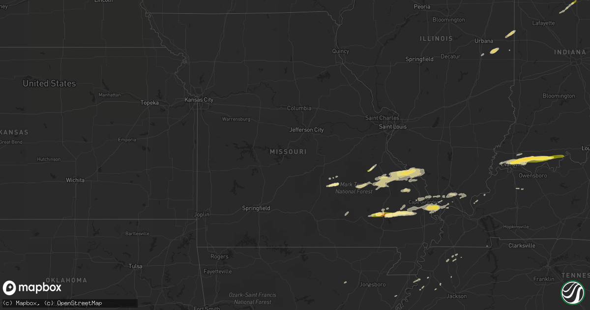
Hail Map in Missouri on May 9, 2014
Get this storm
May 9 map
$229
one time, instant access
Download today. No call, no setup
Keep the $229
Bought the map and want the full workflow? Apply the entire $229 to a subscription within 7 days. None of it is wasted.
Every map, not just this one
This buys you this map. Subscription and you get every map we run, in the markets you choose from a few cities to whole states to nationwide. Plus real-time alerts the moment a storm fires.
Contact data
Name, contact info, occupancy, even credit band for addresses in the footprint. You go from where it hit to who to call.
Become the source they trust
Unlimited branding weather history reports on demand. You already have the documented answer ready for the property owner, and you are the one who showed up with it.
Property data and RoofTrace estimates
Pull up any address you have got, its value and the exact code rules for that jurisdiction, straight from One Click Code. Then RoofTrace estimates the squares, pitch, and roof value, priced the way you price.
Storm reports in Missouri
Missouri
| Date | Description |
|---|---|
| 05/09/20145:30 PM CDT | A local report indicates 1.00 inch wind near 1 SSW FARMINGTON |
| 05/09/20143:32 PM CDT | Tin roof blown off ag building near intersection of highway p and highway 91. Large tree down on highway 25 near advance. |
| 05/09/20143:12 PM CDT | Quarter sized hail 1 mi s of zalma. |
| 05/09/20143:00 PM CDT | Tree limbs down and damage to camper awnings at the old greenville campground. Unconfirmed report of funnel cloud associated with damage. Damage path estimated around o |
| 05/09/20142:53 PM CDT | Several trees down - 9 in dia - branches broken - satelite antenna damaged - minor road flooding. |
| 05/09/20141:44 PM CDT | Quarter mile south of state highway 8...two miles south of mineral point. |
| 05/09/20141:44 PM CDT | Hail from quarter to half dollar size. |
| 05/09/20141:35 PM CDT | Trees down on u.s. Highway 61 |
| 05/09/20141:35 PM CDT | Roof completely blown off a 2 story home. Numerous trees down. A small barn blown across highway 61. Light structural damage to other homes in the area. |
| 05/09/20141:20 PM CDT | Several trees down or uprooted. One old barn collapsed. Reported by sheriffs deputy. |
| 05/09/201411:30 AM CDT | Picture from social media showed ping pong sized hail |
| 05/08/20149:05 PM CDT | A local report indicates 1.00 inch wind near SEDGEWICKVILLE |
All States Impacted by Hail Map on May 9, 2014
Cities Impacted by Hail Map on May 9, 2014
- Leakey, TX
- Karnack, TX
- Vivian, LA
- Mooringsport, LA
- Jefferson, TX
- Belcher, LA
- Oil City, LA
- Boerne, TX
- Boonville, IN
- Chandler, IN
- Tennyson, IN
- Mineral Springs, AR
- Saratoga, AR
- Laredo, TX
- Realitos, TX
- Larue, TX
- Salem, MO
- Hebbronville, TX
- Grandview, TX
- Barksdale, TX
- Itasca, TX
- Jackson, MO
- Cape Girardeau, MO
- Grapeland, TX
- Advance, MO
- Gipsy, MO
- McGee, MO
- Sturdivant, MO
- Zalma, MO
- Texarkana, TX
- Marble Hill, MO
- Sedgewickville, MO
- Uvalde, TX
- Quemado, TX
- Brackettville, TX
- Knippa, TX
- Sabinal, TX
- La Pryor, TX
- Ozan, AR
- Lockesburg, AR
- Nashville, AR
- Shreveport, LA
- Gilmer, TX
- Charlotte, TX
- Jourdanton, TX
- Lovelady, TX
- Palmer, TX
- Trinity, TX
- Mineral Point, MO
- Potosi, MO
- Kenedy, TX
- Marshall, TX
- Gentryville, IN
- Evansville, IN
- Lamar, IN
- Saint Meinrad, IN
- Tell City, IN
- Evanston, IN
- Chrisney, IN
- Newburgh, IN
- Santa Claus, IN
- Paige, TX
- Concepcion, TX
- Blanchard, LA
- Tamms, IL
- Thebes, IL
- Olive Branch, IL
- Dilley, TX
- Canton, TX
- New Boston, TX
- Bismarck, AR
- Amity, AR
- Tilden, TX
- Prescott, AR
- Medina, TX
- Utopia, TX
- Tarpley, TX
- Lockhart, TX
- Dale, TX
- Brownwood, MO
- Greenville, MO
- Wappapello, MO
- Oran, MO
- Daingerfield, TX
- Grand Saline, TX
- Vienna, IL
- Buncombe, IL
- Vanderpool, TX
- Navasota, TX
- Mount Vernon, IN
- Mill Spring, MO
- Saint Mary, MO
- Perryville, MO
- Menard, TX
- Alamo, TN
- Mertens, TX
- Bynum, TX
- Hillsboro, TX
- Milford, TX
- Harleton, TX
- Rosston, AR
- Hooks, TX
- Ashdown, AR
- Salem, KY
- Hampton, KY
- Princeton, LA
- Bismarck, IL
- Alvin, IL
- Danville, IL
- West Lebanon, IN
- San Antonio, TX
- Williamsville, MO
- Piedmont, MO
- Ellsinore, MO
- Cotulla, TX
- Fort McKavett, TX
- San Diego, TX
- Freer, TX
- Karnes City, TX
- Gillett, TX
- Zapata, TX
- Guerra, TX
- San Ygnacio, TX
- Camden, IN
- Logansport, IN
- Hammond, LA
- La Center, KY
- Helotes, TX
- Waskom, TX
- Palestine, TX
- Cuero, TX
- Yorktown, TX
- Montgomery, TX
- Covington, TX
- Camp Wood, TX
- Frankston, TX
- Flint, TX
- Chandler, TX
- New Braunfels, TX
- Bulverde, TX
- Homer, IL
- Longview, IL
- Allerton, IL
- Broadlands, IL
- Jonesboro, AR
- Haughton, LA
- Chester, IL
- Ironton, MO
- Fredericktown, MO
- Sainte Genevieve, MO
- Rockwood, IL
- Farmington, MO
- Doe Run, MO
- Jacob, IL
- Jbsa Lackland, TX
- Atascosa, TX
- Kingsville, TX
- Wilson, AR
- Dyess, AR
- Frohna, MO
- Rocksprings, TX
- Hallsville, TX
- Longview, TX
- Bossier City, LA
- Diana, TX
- Concan, TX
- Mabank, TX
- Eustace, TX
- Kemp, TX
- Millersville, MO
- Daisy, MO
- Patton, MO
- Oak Ridge, MO
- New Waverly, TX
- Sonora, TX
- Forney, TX
- Terrell, TX
- Watson, OK
- Cove, AR
- Spring Branch, TX
- Rio Frio, TX
- Peru, IN
- Galveston, IN
- Walton, IN
- Waelder, TX
- Golconda, IL
- Simpson, IL
- Elkhart, TX
- Henderson, KY
- Kendalia, TX
- Rosanky, TX
- Linden, TX
- Dongola, IL
- Jonesboro, IL
- Anna, IL
- Pipe Creek, TX
- Martin, TN
- Bellville, TX
- Pilot Knob, MO
- Bismarck, MO
- Ava, IL
- Middle Brook, MO
- Campbell Hill, IL
- Arcadia, MO
- Park Hills, MO
- Del Rio, TX
- Christine, TX
- Pleasanton, TX
- Maud, TX
- Falls City, TX
- Avinger, TX
- Crockett, TX
- Kennard, TX
- Marion, KY
- Wimberley, TX
- San Marcos, TX
- Villa Ridge, IL
- Pulaski, IL
- Scott City, MO
- Mounds, IL
- Hawkins, TX
- Eldorado, TX
- Waco, TX
- Riesel, TX
- Corsicana, TX
- Brenham, TX
- Washington, TX
- Canyon Lake, TX
- Rattan, OK
- Lesterville, MO
- Black, MO
- Belleview, MO
- Woodburn, IN
- Montalba, TX
- Bremond, TX
- Franklin, TX
- Fischer, TX
- Ogden, AR
- Encinal, TX
- Queen City, TX
- Emmet, AR
- Hope, AR
- De Kalb, TX
- McClure, IL
- Karnak, IL
- Lowndes, MO
- Miller City, IL
- Grand Chain, IL
- Whitewater, MO
- Cairo, IL
- Chaffee, MO
- Olmsted, IL
- Comstock, TX
- Smithville, TX
- Tuscola, IL
- Pesotum, IL
- Elberfeld, IN
- Bandera, TX
- Pittsburg, TX
- Red Rock, TX
- Sharon, TN
- Crystal City, TX
- Clubb, MO
- Slaughters, KY
- Sebree, KY
- Ida, MI
- Petersburg, MI
- Gonzales, TX
- West Point, TX
- Muldoon, TX
- Premont, TX
- Alice, TX
- Halls, TN
- Big Sandy, TX
- Ripley, TN
- Athens, TX
- Coldspring, TX
- Giddings, TX
- Trenton, TN
- Atlanta, TX
- Kenton, TN
- Rives, TN
- Waldron, MI
- Saffell, AR
- Cord, AR
- Powell, TX
- Kerens, TX
- Bivins, TX
- Leopold, IN
- Silva, MO
- Willis, TX
- Encino, TX
- Winona, MO
- Anderson, TX
- Monroe, IN
- Fairmount, IL
- Santa Elena, TX
- Ullin, IL
- Ferris, TX
- Ennis, TX
- Waxahachie, TX
- Texarkana, AR
- Crandall, TX
- Dresden, TN
- Haworth, OK
- Rio Vista, TX
- Blum, TX
- Bonne Terre, MO
- D Hanis, TX
- Perrysville, IN
- Flatonia, TX
- Antwerp, OH
- Westhoff, TX
- La Grange, TX
- Axtell, TX
- Stockdale, TX
- Troup, TX
- Georgetown, IL
- Ridge Farm, IL
- Cushing, TX
- Laneville, TX
- Lone Star, TX
- Smithville, OK
- Louisville, KY
- Delight, AR
- Murfreesboro, AR
- New Concord, KY
- Bergheim, TX
- McCaskill, AR
- Blanco, TX
- Henderson, TX
- Brownsville, TN
- Deerfield, MI
- Blissfield, MI
- Cypress, IL
- Goreville, IL
- Rumsey, KY
- Luling, TX
- Batesville, TX
- Pearsall, TX
- Kosse, TX
- Fulton, AR
- Simms, TX
- College Station, TX
- Plantersville, TX
- Payne, OH
- New Waverly, IN
- Bristow, IN
- Grandview, IN
- Branchville, IN
- Leavenworth, IN
- Cannelton, IN
- Battletown, KY
- Troy, IN


