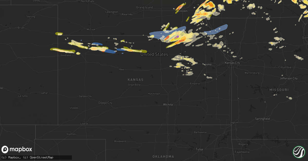
Hail Map in Kansas on May 7, 2023
Get this storm
May 7 map
$229
one time, instant access
Download today. No call, no setup
Keep the $229
Bought the map and want the full workflow? Apply the entire $229 to a subscription within 7 days. None of it is wasted.
Every map, not just this one
This buys you this map. Subscription and you get every map we run, in the markets you choose from a few cities to whole states to nationwide. Plus real-time alerts the moment a storm fires.
Contact data
Name, contact info, occupancy, even credit band for addresses in the footprint. You go from where it hit to who to call.
Become the source they trust
Unlimited branding weather history reports on demand. You already have the documented answer ready for the property owner, and you are the one who showed up with it.
Property data and RoofTrace estimates
Pull up any address you have got, its value and the exact code rules for that jurisdiction, straight from One Click Code. Then RoofTrace estimates the squares, pitch, and roof value, priced the way you price.
Storm reports in Kansas
Kansas
| Date | Description |
|---|---|
| 05/07/20236:35 PM CDT | Public report via social media with photo/video of accumulating pea to nickel size hail... Winds 60+ mph... And blowing dust with visibility about 30 feet at times... T |
| 05/07/20236:27 PM CDT | Public report via social media of 65 mph winds and blowing dust reducing visibility to a quarter mile at times. |
| 05/07/20236:03 PM CDT | Report via social media of 2 inch hail. |
| 05/07/20235:59 PM CDT | A local report indicates 65 MPH wind near 5 S SELDEN |
| 05/07/20235:29 PM CDT | A local report indicates 58 MPH wind near 2 N ATWOOD |
| 05/07/20234:35 PM CDT | Retired nws employee reports 1-1.5 inch hail... Some light accumulation. Prior to hail... Blowing dust with 1/4 mile visibility occurred. |
| 05/07/20234:35 PM CDT | Nws employee reported penny to quarter size hail covering the ground at the intersection of hwy 27 and county road 73 at 3:35 pm mdt |
| 05/07/20234:20 PM CDT | Public report via social media with photo of 1-1.25 inch hail. Time estimated. |
| 05/07/20234:18 PM CDT | Social media report of hail ranging from pea to around to bigger than golf ball size hail. Hail lasted around 20 minutes. |
| 05/07/20234:13 PM CDT | Ping pong size hail reported 10 miles north of ruleton at 3:13 pm mdt |
| 05/06/202310:50 PM CDT | Delayed report. |
| 05/06/202310:19 PM CDT | Report from mping: 1-inch tree limbs broken; shingles blown off. |
| 05/06/202310:10 PM CDT | Personal weather station. |
| 05/06/20239:44 PM CDT | Personal weather station. |
| 05/06/20239:30 PM CDT | Personal weather station. |
| 05/06/20239:29 PM CDT | A local report indicates 1.25 inch wind near 1 ENE BREMEN |
| 05/06/20239:29 PM CDT | Kcnk asos measurement. |
| 05/06/20239:09 PM CDT | Kcnk asos measurement. |
| 05/06/20238:56 PM CDT | Report via spotter network. |
| 05/06/20238:55 PM CDT | A local report indicates 1.25 inch wind near MARYSVILLE |
| 05/06/20238:45 PM CDT | Corrects time of previous tstm wnd dmg report from beloit. Report from mping: 1-inch tree limbs broken; shingles blown off. |
| 05/06/20238:44 PM CDT | A local report indicates 59 MPH wind near BELOIT |
| 05/06/20238:37 PM CDT | A local report indicates 61 MPH wind near JEWELL |
| 05/06/20238:26 PM CDT | Slightly larger than quarter size. |
| 05/06/20238:23 PM CDT | Quarter to ping pong ball size hail. |
| 05/06/20238:22 PM CDT | Spotter network report. |
| 05/06/20238:15 PM CDT | A local report indicates 60 MPH wind near SMITH CENTER AIRPORT |
| 05/06/20238:15 PM CDT | A local report indicates 1.00 inch wind near 6 N HANOVER |
| 05/06/20238:05 PM CDT | Davis weatherlink station. |
| 05/06/20238:03 PM CDT | A local report indicates 1.00 inch wind near 2 WNW LINN |
| 05/06/20237:56 PM CDT | Law enforcement reports golf ball size hail in alton. |
| 05/06/20237:39 PM CDT | A local report indicates 68 MPH wind near 3 ENE WOODSTON |
| 05/06/20237:39 PM CDT | Pea to quarter size hail. |
| 05/06/20237:36 PM CDT | A local report indicates 1.50 inch wind near MORROWVILLE |
| 05/06/20237:32 PM CDT | Davis watherlink. |
| 05/06/20237:32 PM CDT | Davis weatherlink. |
| 05/06/20237:26 PM CDT | Ambient weather station. |
| 05/06/20237:16 PM CDT | A few nickel to quarter sized hailstones. |
All States Impacted by Hail Map on May 7, 2023
Cities Impacted by Hail Map on May 7, 2023
- Perrysville, IN
- Covington, IN
- Williamsport, IN
- Attica, IN
- Shelbyville, KY
- Carbondale, IL
- Tamaroa, IL
- Sesser, IL
- Scheller, IL
- Ozark, IL
- Creal Springs, IL
- New Burnside, IL
- Stonefort, IL
- Gillett, TX
- Corydon, IN
- Leavenworth, IN
- Falls City, TX
- Mulkeytown, IL
- Benton, IL
- Du Quoin, IL
- Floresville, TX
- Cave City, KY
- Evansville, IN
- Elberfeld, IN
- Haubstadt, IN
- Dakota City, NE
- Cotulla, TX
- Henryville, IN
- Sellersburg, IN
- Borden, IN
- Memphis, IN
- Herod, IL
- Eddyville, IL
- George West, TX
- Glasgow, KY
- Crystal City, TX
- La Pryor, TX
- Batesville, TX
- Hubbard, NE
- Utica, KY
- Hartford, KY
- Cynthiana, KY
- Lynnville, IN
- Meadow Grove, NE
- Springerton, IL
- Mill Shoals, IL
- Burnt Prairie, IL
- Carmi, IL
- Enfield, IL
- Pomona, IL
- Murphysboro, IL
- Raleigh, IL
- Harrisburg, IL
- Galatia, IL
- Eckerty, IN
- Lewisport, KY
- Beecher City, IL
- Dale, IN
- Winnebago, NE
- Jasper, IN
- Philpot, KY
- New Salisbury, IN
- Georgetown, IN
- Brooks, KY
- Louisville, KY
- Fairdale, KY
- Oakland, IL
- Shepherdsville, KY
- Elizabeth, IN
- West Point, KY
- Golden Gate, IL
- Ellery, IL
- Nortonville, KY
- White Plains, KY
- Owensville, IN
- Princeton, IN
- Yorktown, TX
- Lebanon Junction, KY
- Bardstown, KY
- Boston, KY
- Coxs Creek, KY
- Clermont, KY
- Mount Vernon, IN
- Earlington, KY
- Mortons Gap, KY
- Dawson Springs, KY
- Madisonville, KY
- Guthrie Center, IA
- Sharpsburg, KY
- Owingsville, KY
- Makanda, IL
- New Albany, IN
- Dixon, KY
- Buckner, IL
- Logan, IL
- Christopher, IL
- West Frankfort, IL
- Thompsonville, IL
- Waverly, OH
- Beaver, OH
- Gentryville, IN
- Stendal, IN
- Boonville, IN
- Holland, IN
- Tennyson, IN
- Nordheim, TX
- Cuero, TX
- New Middletown, IN
- Lanesville, IN
- Laconia, IN
- Brandenburg, KY
- Campbellsburg, IN
- Salem, IN
- Newburgh, IN
- Sigel, IL
- Neoga, IL
- Leitchfield, KY
- Brownsville, KY
- Roundhill, KY
- Caneyville, KY
- Bee Spring, KY
- English, IN
- Berry, KY
- Karnes City, TX
- Runge, TX
- Milltown, IN
- Depauw, IN
- Whitesville, KY
- Taswell, IN
- Urbana, IL
- Saint Joseph, IL
- Champaign, IL
- Rockport, IN
- Chrisney, IN
- Grandview, IN
- Morgantown, KY
- Sweeden, KY
- Graham, KY
- Bremen, KY
- Springfield, KY
- Broughton, IL
- Norris City, IL
- Mauckport, IN
- Greenville, KY
- Sacramento, KY
- Goreville, IL
- Winslow, IN
- Hanson, KY
- Providence, KY
- Princeton, KY
- Saint Charles, KY
- Nebo, KY
- Manitou, KY
- Ogden, IL
- Horse Branch, KY
- Slaughters, KY
- McLeansboro, IL
- Dale, IL
- Macedonia, IL
- Orient, IL
- Kenedy, TX
- Beeville, TX
- Dahlgren, IL
- Paoli, IN
- Pekin, IN
- Hardinsburg, IN
- Fredericksburg, IN
- Thomasboro, IL
- Marion, IL
- Mount Sterling, KY
- Carlisle, KY
- Paris, KY
- Drakesboro, KY
- Poth, TX
- Simpson, IL
- Elizabethtown, IL
- Panora, IA
- Sebree, KY
- Wadesville, IN
- New Harmony, IN
- Finchville, KY
- Richland, IN
- Omaha, IL
- Ridgway, IL
- Campbellton, TX
- Dow City, IA
- Arion, IA
- Denison, IA
- Simpsonville, KY
- Chandler, IN
- Stewardson, IL
- Three Rivers, TX
- Tuscola, IL
- Manning, IA
- Westside, IA
- Arcadia, IA
- Carroll, IA
- Halbur, IA
- Glidden, IA
- Addieville, IL
- Okawville, IL
- Nashville, IL
- Hoyleton, IL
- Golconda, IL
- Smithland, KY
- Hampton, KY
- Manilla, IA
- Vail, IA
- Rosiclare, IL
- Sharon, TN
- Dresden, TN
- Greenfield, TN
- Gleason, TN
- Waverly, IL
- Loami, IL
- Chatham, IL
- Energy, IL
- Carterville, IL
- Johnston City, IL
- Herrin, IL
- Pittsburg, IL
- Bonnie, IL
- Mount Vernon, IL
- Waltonville, IL
- Opdyke, IL
- Dunning, NE
- Henry, TN
- McKenzie, TN
- Paris, TN
- Belle Rive, IL
- Eldorado, IL
- Auburn, IL
- Springfield, IL
- Purdum, NE
- Glenarm, IL
- Divernon, IL
- Pawnee, IL
- Boone, IA
- Ames, IA
- Gilbert, IA
- Nevada, IA
- Story City, IA
- Virden, IL
- Roland, IA
- Zearing, IA
- McCallsburg, IA
- Cambridge, IA
- Maxwell, IA
- Collins, IA
- Colo, IA
- Mingo, IA
- Baxter, IA
- Rhodes, IA
- State Center, IA
- Melbourne, IA
- Toledo, IA
- Clutier, IA
- Tama, IA
- Chelsea, IA
- Vining, IA
- Elberon, IA
- Morrisonville, IL
- Roscoe, TX
- Clarksville, TN
- Oak Grove, KY
- Colfax, IA
- Trenton, KY
- Newton, IA
- Sweetwater, TX
- Roby, TX
- Oliver Springs, TN
- Briceville, TN
- Powell, TN
- Clinton, TN
- Heiskell, TN
- Hopkinsville, KY
- Herndon, KY
- Cadiz, KY
- Rowena, TX
- Miles, TX
- Ira, IA
- Ballinger, TX
- Haverhill, IA
- Laurel, IA
- Idalia, CO
- Burlington, CO
- Kanorado, KS
- Goodland, KS
- Mereta, TX
- Charleston, MO
- New Berlin, IL
- Industry, IL
- Adair, IL
- Belle Plaine, IA
- Vermont, IL
- Hartwick, IA
- Victor, IA
- Marengo, IA
- Knoxville, TN
- Van Horne, IA
- Luzerne, IA
- Ladora, IA
- Blairstown, IA
- Keystone, IA
- Haigler, NE
- Rotan, TX
- Wray, CO
- Hamlin, TX
- Grinnell, IA
- Gilman, IA
- Kellogg, IA
- Palmer, IL
- Nokomis, IL
- Lynnville, IA
- Rushville, IL
- Bird City, KS
- Wickliffe, KY
- Barlow, KY
- Snyder, TX
- Searsboro, IA
- Montezuma, IA
- Malcom, IA
- Seymour, TX
- Guthrie, KY
- Allensville, KY
- Elkton, KY
- Olmstead, KY
- Russellville, KY
- La Center, KY
- Rosamond, IL
- Winters, TX
- Edson, KS
- McDonald, KS
- Aspermont, TX
- Middle Amana, IA
- Amana, IA
- Watkins, IA
- Norway, IA
- Fort Madison, IA
- West Point, IA
- Alzada, MT
- Wever, IA
- Hulett, WY
- Astoria, IL
- Ipava, IL
- Adairville, KY
- Brooklyn, IA
- Kevil, KY
- Barnes City, IA
- Williamsburg, IA
- Conroy, IA
- South Amana, IA
- Tiffin, IA
- Oxford, IA
- Homestead, IA
- Iowa City, IA
- Coralville, IA
- Swisher, IA
- North Liberty, IA
- Sylvester, TX
- Ohlman, IL
- Pana, IL
- Oconee, IL
- Fairfax, IA
- Auburn, KY
- Franklin, KY
- Alexander, IL
- Guernsey, IA
- Gibson, IA
- Deep River, IA
- Pleasant Plains, IL
- Ashland, IL
- Mansfield, TN
- Pella, IA
- Springville, TN
- Sully, IA
- Levant, KS
- Colby, KS
- Brewster, KS
- New Sharon, IA
- Atwood, KS
- Browning, IL
- Havana, IL
- Kilbourne, IL
- Bath, IL
- Chandlerville, IL
- Benjamin, TX
- Cumberland Furnace, TN
- Vanleer, TN
- Ovalo, TX
- Solon, IA
- Boaz, KY
- Hickory, KY
- Sedalia, KY
- Tallula, IL
- Tuscola, TX
- Charlotte, TN
- Wellman, IA
- North English, IA
- Parnell, IA
- Keswick, IA
- Webster, IA
- Buffalo Gap, TX
- Oskaloosa, IA
- Rose Hill, IA
- Burlington, IA
- West Paducah, KY
- Lone Tree, IA
- Wingate, TX
- West Branch, IA
- Belleville, IL
- O'Fallon, IL
- Merkel, TX
- Abilene, TX
- Tye, TX
- Waverly, TN
- McEwen, TN
- Erin, TN
- Rapid City, SD
- Lebanon, IL
- What Cheer, IA
- Delta, IA
- Gracey, KY
- New Athens, IL
- West Liberty, IA
- Atalissa, IA
- Tipton, IA
- White Bluff, TN
- Kalona, IA
- Ellsworth Afb, SD
- Box Elder, SD
- Selden, KS
- Dickson, TN
- McCaulley, TX
- Anson, TX
- Kingston Springs, TN
- Aladdin, WY
- Sigourney, IA
- Riverside, IA
- Harper, IA
- Hills, IA
- Keota, IA
- South English, IA
- Dresden, KS
- Hawley, TX
- Trent, TX
- Hayesville, IA
- Carman, IL
- Stronghurst, IL
- Lomax, IL
- Almo, KY
- Hardin, KY
- Benton, KY
- Media, IL
- Raritan, IL
- Ollie, IA
- Kirksey, KY
- Murray, KY
- Roseville, IL
- Smithshire, IL
- Villa Ridge, IL
- Dexter, KY
- Paint Rock, TX
- Nichols, IA
- Muscatine, IA
- Moscow, IA
- Wilton, IA
- Jennings, KS
- Oberlin, KS
- Freeburg, IL
- Durant, IA
- Blue Grass, IA
- Stockton, IA
- New Underwood, SD
- Port Byron, IL
- Hillsdale, IL
- Hillsboro, IL
- Butler, IL
- Clayton, KS
- Lenora, KS
- Morland, KS
- Eola, TX
- San Angelo, TX
- Irving, IL
- Coon Rapids, IA
- Jewell, IA
- Randall, IA
- Jefferson, IA
- Churdan, IA
- Scranton, IA
- Red Bud, IL
- Marine, IL
- Edwardsville, IL
- Metropolis, IL
- Pocahontas, IL
- Radcliffe, IA
- Sullivan, IN
- Taylorville, IL
- Big Rock, TN
- La Fayette, KY
- Stanhope, IA
- Vienna, IL
- Caryville, TN
- Highland, IL
- Trenton, IL
- Aviston, IL
- Breese, IL
- Russellville, TN
- Salem, KY
- Marion, KY
- Breda, IA
- Tallulah, LA
- Richview, IL
- Ashley, IL
- Farmersville, IL
- Bardwell, KY
- Louisville, IL
- Calvert City, KY
- Symsonia, KY
- Paducah, KY
- Carlyle, IL
- Maryville, IL
- Granite City, IL
- Collinsville, IL
- Audubon, IA
- Dukedom, TN
- Fulton, KY
- Odin, IL
- Salem, IL
- Macomb, IL
- Marshalltown, IA
- Lewisburg, KY
- Centralia, IL
- Whitesburg, TN
- Morristown, TN
- Crowell, TX
- Kinmundy, IL
- Fairview Heights, IL
- Scott Air Force Base, IL
- South Fulton, TN
- Martin, TN
- Eddyville, KY
- Lake City, IA
- Hammond, MT
- Lenzburg, IL
- Jefferson City, TN
- De Soto, IL
- Alto Pass, IL
- Cambria, IL
- Wolf Lake, IL
- Pembroke, KY
- Melber, KY
- Cunningham, KY
- Talbott, TN
- White Pine, TN
- Dandridge, TN
- New Market, TN
- Newport, TN
- Fredonia, KY
- Du Bois, IL
- Ina, IL
- Kuttawa, KY
- Scottsville, KY
- Bean Station, TN
- Oakdale, IL
- Mohawk, TN
- Rives, TN
- Pulaski, IL
- Grand Chain, IL
- Karnak, IL
- Mayfield, KY
- Mounds, IL
- Ullin, IL
- Olmsted, IL
- Beech Creek, KY
- Belton, KY
- Dunmor, KY
- New Baden, IL
- Alva, WY
- Palmyra, TN
- Cumberland City, TN
- Fort Campbell, KY
- Wartburg, TN
- Elkville, IL
- Xenia, IL
- Farina, IL
- Crofton, KY
- Vergennes, IL
- Ralston, IA
- Gilbertsville, KY
- Crossville, IL
- Walshville, IL
- Litchfield, IL
- Thorn Hill, TN
- Saint Francis, KS
- Stewart, TN
- Tennessee Ridge, TN
- Big Sandy, TN
- Hurst, IL
- Royalton, IL
- Saint Jacob, IL
- Seneca, NE
- Thedford, NE
- Halsey, NE
- Hermleigh, TX
- Huntsville, TN
- Rocky Top, TN
- Jonesboro, IL
- Orlinda, TN
- Springfield, TN
- Buncombe, IL
- Dongola, IL
- Woodlawn, IL
- Carrier Mills, IL
- Equality, IL
- Zeigler, IL
- Ava, IL
- Dowell, IL
- Belknap, IL
- Cobden, IL
- Cypress, IL
- Anna, IL
- Jamestown, TN
- Deer Lodge, TN
- Millstadt, IL
- Grand Rivers, KY
- Miller City, IL
- Thebes, IL
- Taylor Springs, IL
- Robards, KY
- Tamms, IL
- Pinckneyville, IL
- New Haven, IL
- Pine Bluff, AR
- Midkiff, TX
- Merom, IN
- Mascoutah, IL
- Pegram, TN
- Nashville, TN
- Franklin, TN
- Brentwood, TN
- Coffeen, IL
- Big Lake, TX
- Garden City, TX
- Raymond, IL
- Nilwood, IL
- Waggoner, IL
- Carlinville, IL
- Washington, IA
- Wayland, IA
- Richland, IA
- Fairfield, IA
- Brighton, IA
- Colona, IL
- Geneseo, IL
- Antioch, TN
- Ozona, TX
- Iraan, TX
- Prophetstown, IL
- Hooppole, IL
- Walcott, IA
- Davenport, IA
- Hill City, KS
- Penokee, KS
- Wheatland, IA
- Lost Nation, IA
- Lowden, IA
- Grand Mound, IA
- Bennett, IA
- Donahue, IA
- Dixon, IA
- Calamus, IA
- New Liberty, IA
- Long Grove, IA
- Goose Lake, IA
- De Witt, IA
- Delmar, IA
- Norcatur, KS
- Eldridge, IA
- Moline, IL
- McCausland, IA
- Rock Island, IL
- Princeton, IA
- Camanche, IA
- Bettendorf, IA
- Le Claire, IA
- Clinton, IA
- Coal Valley, IL
- Hampton, IL
- Carbon Cliff, IL
- Low Moor, IA
- Pleasant Valley, IA
- East Moline, IL
- Silvis, IL
- Cordova, IL
- Rapids City, IL
- Harvel, IL
- Packwood, IA
- Winfield, IA
- Mount Pleasant, IA
- Mount Union, IA
- Yarmouth, IA
- Good Hope, IL
- Avon, IL
- Prairie City, IL
- Bushnell, IL
- Colchester, IL
- Owanka, SD
- Annawan, IL
- Bogue, KS
- Albany, IL
- Erie, IL
- Fulton, IL
- Kensington, KS
- Smith Center, KS
- Belleville, KS
- Scandia, KS
- Mankato, KS
- Esbon, KS
- Logan, KS
- Gaylord, KS
- Kirwin, KS
- Courtland, KS
- Phillipsburg, KS
- Athol, KS
- Lebanon, KS
- Glade, KS
- Prairie View, KS
- Cuba, KS
- Grant Park, IL
- Momence, IL
- Morning Sun, IA
- Narka, KS
- Mahaska, KS
- Mediapolis, IA
- Haddam, KS
- Schneider, IN
- Lowell, IN
- Stockton, KS
- Hebron, NE
- Newark, IL
- Gilead, NE
- Alexandria, NE
- Belvidere, NE
- Daykin, NE
- Tobias, NE
- Unadilla, NE
- Burr, NE
- Syracuse, NE
- Mendota, IL
- Fairbury, NE
- Sublette, IL
- La Moille, IL
- Ohio, IL
- Amboy, IL
- Sciota, IL
- Bardolph, IL
- Pacific Junction, IA
- Plattsmouth, NE
- Glenwood, IA
- Mount Sterling, IL
- Malvern, IA
- Morrowville, KS
- New London, IA
- Sperry, IA
- Washington, KS
- Table Grove, IL
- Marietta, IL
- Otoe, NE
- Dunbar, NE
- Woodston, KS
- Morris, IL
- Seneca, IL
- Wasta, SD
- Wall, SD
- Endicott, NE
- Hollenberg, KS
- Clyde, KS
- Clifton, KS
- Palmer, KS
- Avoca, NE
- Nehawka, NE
- Western, NE
- Smithfield, IL
- Cuba, IL
- Jansen, NE
- Knox City, TX
- Munday, TX
- Biggsville, IL
- Gladstone, IL
- Lewistown, IL
- Alton, KS
- Tabor, IA
- Hastings, IA
- Linn, KS
- Diller, NE
- Hanover, KS
- Adams, NE
- Plymouth, NE
- Douglas, NE
- Palmyra, NE
- Firth, NE
- Nebraska City, NE
- Weeping Water, NE
- Murray, NE
- Osborne, KS
- Portis, KS
- Corning, IA
- Bridgewater, IA
- Prescott, IA
- Fontanelle, IA
- Massena, IA
- Orient, IA
- Belle Fourche, SD
- Clinton, KY
- Villisca, IA
- Nisland, SD
- Newell, SD
- Cumberland, IA
- Emerson, IA
- Sterling, NE
- Cook, NE
- Talmage, NE
- Lorton, NE
- Downs, KS
- Greenleaf, KS
- Percival, IA
- Thurman, IA
- Union, NE
- Odell, NE
- Bremen, KS
- Marysville, KS
- Cawker City, KS
- Steele City, NE
- Blue Springs, NE
- Wymore, NE
- Dallas City, IL
- Blandinsville, IL
- Carthage, IL
- La Harpe, IL
- West Burlington, IA
- Barnes, KS
- Tennessee, IL
- Glen Elder, KS
- Milford, NE
- Pleasant Dale, NE
- Lincoln, NE
- Denton, NE
- Quinn, SD
- Malcolm, NE
- Philip, SD
- Raymond, NE
- Davey, NE
- Ceresco, NE
- Sturgis, SD
- Whitewood, SD
- Vale, SD
- Seward, NE
- Garland, NE
- Oketo, KS
- Creston, IA
- Beloit, KS
- Waterville, KS
- Stanton, IA
- Red Oak, IA
- Wilmington, IL
- Channahon, IL
- Coal City, IL
- Elwood, IL
- Silver City, IA
- Mineola, IA
- Plymouth, IL
- Sidney, IA
- Hamburg, IA
- Liberty, NE
- Barneston, NE
- Beattie, KS
- Tecumseh, NE
- Brock, NE
- Johnson, NE
- Peru, NE
- Julian, NE
- Waverly, NE
- Home, KS
- Summerfield, KS
- Burchard, NE
- Riverton, IA
- Rock Port, MO
- Farragut, IA
- Superior, NE
- Webber, KS
- Hardy, NE
- Clyde, TX
- Hubbard, IA
- New Providence, IA
- Union, IA
- Eldora, IA
- Pembroke Township, IL
- Saint Anne, IL
- Beaverville, IL
- Morocco, IN
- Palo Pinto, TX
- Brook, IN
- Graford, TX
- Mineral Wells, TX
- Guntown, MS
- Baldwyn, MS
- Pawnee City, NE
- Oakland, IA
- Booneville, MS
- Marietta, MS
- Walnut, IA
- Avoca, IA
- Hancock, IA
- Mount Ayr, IN
- Whitten, IA
- Conrad, IA
- Fairbank, IA
- Dunkerton, IA
- Jesup, IA
- Independence, IA
- Hazleton, IA
- Hudson, IA
- La Porte City, IA
- Waterloo, IA
- Buckingham, IA
- Dyess Afb, TX
- Council Bluffs, IA
- McClelland, IA
- Underwood, IA
- Beaman, IA
- Baird, TX
- Liscomb, IA
- Ogden, IA
- Republic, KS
- Ruskin, NE
- Nelson, NE
- Byron, NE
- Hubbell, NE
- Deshler, NE
- Munden, KS
- Chester, NE
- Reynolds, NE
- Dawson, NE
- Salem, NE
- Verdon, NE
- Falls City, NE
- Neola, IA
- Minden, IA
- Craig, MO
- Rulo, NE
- Gladbrook, IA
- Shelby, IA
- Trezevant, TN
- Huntingdon, TN
- Riley, KS
- Manhattan, KS
- Beatrice, NE
- Saint George, KS
- Osceola, IA
- Mound City, MO
- Maitland, MO
- Skidmore, MO
- Weldon, IA
- Woodburn, IA
- Filley, NE
- Graham, MO
- Barnard, MO
- Maryville, MO
- Conception Junction, MO
- Virginia, NE
- Wamego, KS
- Kokomo, IN
- Bunker Hill, IN
- Sheffield, IL
- Manlius, IL
- Piedmont, SD
- Middletown, IA
- Danville, IA
- La Salle, IL
- Peru, IL
- Alma, IL
- Ethel, MS
- Van Orin, IL
- Walnut, IL
- Caseyville, IL
- White Hall, AR
- Saint Onge, SD
- Spearfish, SD
- Bruning, NE
- Humboldt, NE
- Ramsey, IL
- Fillmore, IL
- Mulberry Grove, IL
- West Point, IL
- Bowen, IL
- Hillsboro, TN
- Morrison, TN
- Lake Village, IN
- Dover, TN
- Indian Mound, TN
- Beardstown, IL
- Virginia, IL
- Arenzville, IL
- Meredosia, IL
- Castalian Springs, TN
- Gallatin, TN
- Alexis, IL
- Niota, IL
- Saint Anthony, IA
- Clemons, IA
- Kirkwood, IL
- Carlisle, AR
- Norton, KS
- Lexington, MS
- Benton, MS
- Yazoo City, MS
- Blue Rapids, KS
- Kankakee, IL
- Aroma Park, IL
- Donnellson, IA
- Girard, IL
- Palmyra, IL
- Vicksburg, MS
- Atkinson, IL
- Weinert, TX
- Goree, TX
- Mertzon, TX
- Burnettsville, IN
- Royal Center, IN
- Frankfort, KS
- Auburn, NE
- Farmington, KY
- Spencer, TN
- Timewell, IL
- Bentonia, MS
- Robinson, IL
- Wakefield, KS
- Milford, KS
- Clay Center, KS
- Leonardville, KS
- Sheridan, IL
- Ottawa, IL
- Aledo, IL
- Seaton, IL
- Belzoni, MS
- Altheimer, AR
- Essex, IA
- Shenandoah, IA
- Imogene, IA
- Carson, IA
- Treynor, IA
- Jacksonville, IL
- Concord, IL
- Iuka, MS
- Hedrick, IA
- Manteno, IL
- Corning, KS
- Centralia, KS
- Traer, IA
- Owaneco, IL
- Bingham, IL
- Palmersville, TN
- Utica, MS
- Crystal Springs, MS
- Hazlehurst, MS
- Sherrill, AR
- Illinois City, IL
- New Boston, IL
- Yorkville, IL
- Junction City, KS
- Fort Riley, KS
- Saltillo, MS
- Coin, IA
- Henderson, IA
- Yorktown, IA
- Clarinda, IA
- Randolph, IA
- Elvaston, IL
- Warsaw, IL
- Basco, IL
- Modesto, IL
- Long Island, KS
- Fruitland, IA
- Letts, IA
- Joy, IL
- Manchester, TN
- Beechgrove, TN
- Bradyville, TN
- Tracy City, TN
- Whitwell, TN
- Gerlaw, IL
- Sunset, SC
- Fayetteville, TN
- Woodbury, TN
- Carleton, NE
- Cedar Rapids, IA
- Hermanville, MS
- Wabash, IN
- Peru, IN
- Denver, IN
- O'Brien, TX
- Columbus Junction, IA
- Wapello, IA
- Guide Rock, NE
- Seneca, KS
- Bern, KS
- Bourbonnais, IL
- Rock Island, TN
- Fair Oaks, IN
- Gillespie, IL
- Bunker Hill, IL
- Wabbaseka, AR
- Humphrey, AR
- Camden, IL
- Table Rock, NE
- Readyville, TN
- Sorento, IL
- Doyle, TN
- Pikeville, TN
- Quebeck, TN
- Baileyville, KS
- Axtell, KS
- Du Bois, NE
- Steinauer, NE
- Lockridge, IA
- Bartelso, IL
- Vaughan, MS
- Pickens, MS
- Christiana, TN
- Murfreesboro, TN
- Burns, TN
- Cunningham, TN
- Fairview, TN
- Nolensville, TN
- Morrill, KS
- Sabetha, KS
- Mount Olive, IL
- Rochester, IL
- Witt, IL
- New Douglas, IL
- Thayer, IL
- Franklin, IL
- Benld, IL
- Mcminnville, TN
- Rochester, TX
- Rule, TX
- Agra, KS
- Nemaha, NE
- Altamont, TN
- Beersheba Springs, TN
- Brookport, IL
- New Bedford, IL
- Tampico, IL
- Coalmont, TN
- Grandview, IA
- East Prairie, MO
- Summerfield, IL
- Smithville, TN
- Old Glory, TX
- Oxford Junction, IA
- Clarence, IA
- Griswold, IA
- Galesburg, IL
- Cameron, IL
- Monmouth, IL
- Rensselaer, IN
- Crawfordsville, IA
- Olds, IA
- Logansport, IN
- Jamaica, IA
- Yale, IA
- Rippey, IA
- Bagley, IA
- Vermillion, KS
- Kewanna, IN
- Wedron, IL
- Serena, IL
- Marseilles, IL
- Almena, KS
- Frankewing, TN
- Cornersville, TN
- Petersburg, TN
- Pulaski, TN
- Hartsville, TN
- Dwight, IL
- Emington, IL
- Odell, IL
- Earlville, IL
- Walling, TN
- Papineau, IL
- Martinton, IL
- Princeton, IL
- Medaryville, IN
- Francesville, IN
- Wheatfield, IN
- Caddo, TX
- Breckenridge, TX
- Chaffee, MO
- Scott City, MO
- Dellrose, TN
- Woodward, IA
- Granger, IA
- Chillicothe, TX
- Glen Carbon, IL
- Lonoke, AR
- England, AR
- Idaville, IN
- Star City, IN
- Joliet, IL
- Taylor Ridge, IL
- Flora, MS
- Palestine, IL
- Parsons, TN
- Arlington, KY
- Minooka, IL
- Demotte, IN
- Troy, IL
- Fancy Farm, KY
- Burna, KY
- Utica, IL
- Linden, TN
- Michie, TN
- Peotone, IL
- Ashland City, TN
- Madrid, IA
- Centerville, IA
- Seymour, IA
- Vinton, IA
- Rowley, IA
- Ellsworth, IA
- Afton, IA
- Thayer, IA
- Ottumwa, IA
- Eddyville, IA
- Chillicothe, IA
- Kirkville, IA
- Huntsville, IL
- Slater, IA
- Alden, IA
- Argyle, IA
- Farmington, IA
- Kahoka, MO
- Wayland, MO
- Lawrenceburg, TN
- Collinwood, TN
- Waynesboro, TN
- Lutts, TN
- Cypress Inn, TN
- Loraine, IL
- Anamosa, IA
- Wyoming, IA
- Center Junction, IA
- Olin, IA
- Martelle, IA
- Everest, KS
- Lancaster, KS
- Denton, KS
- Wathena, KS
- Troy, KS
- Janesville, IA
- Waverly, IA
- North Henderson, IL
- Carrizo Springs, TX
- Wilsonville, IL
- Wolcott, IN
- Polk City, IA
- Harlan, IA
- Vassar, KS
- Lyndon, KS
- Quenemo, KS
- Perry, IA
- King City, MO
- Denver, IA
- Readlyn, IA
- Cedar Falls, IA
- Burnsville, MS
- Nauvoo, IL
- Grundy Center, IA
- Brownville, NE
- Promise City, IA
- Corydon, IA
- Wilsey, KS
- Osage City, KS
- Burlingame, KS
- Green Castle, MO
- Novinger, MO
- Garwin, IA
- Dysart, IA
- Chapman, KS
- Alta Vista, KS
- Abilene, KS
- Dwight, KS
- Enterprise, KS
- Alma, KS
- Weston, MO
- Lineville, IA
- Garden Grove, IA
- Reinbeck, IA
- Lorimor, IA
- Macksburg, IA
- Kelley, IA
- Garrison, IA
- Mount Auburn, IA
- Oelwein, IA
- Baldwin, IA
- Maquoketa, IA
- Murray, IA
- Panama, IL
- Donnellson, IL
- Faucett, MO
- Saint Joseph, MO
- De Kalb, MO
- Cromwell, IA
- Germantown, IL
- Humeston, IA
- Chariton, IA
- Derby, IA
- Dearborn, MO
- Wyaconda, MO
- Manhattan, IL
- Unionville, MO
- Highland, KS
- White Cloud, KS
- Robinson, KS
- Council Grove, KS
- Shell Rock, IA
- Manley, NE
- Louisville, NE
- Murdock, NE
- Topeka, KS
- Paxico, KS
- Olsburg, KS
- McFarland, KS
- Belvue, KS
- Maple Hill, KS
- Ellston, IA
- Shannon City, IA
- Tingley, IA
- Fairview, KS
- Goff, KS
- Wetmore, KS
- Strawn, TX
- Comstock, TX
- Sparland, IL
- Oregon, MO
- Fillmore, MO
- Hiawatha, KS
- Bendena, KS
- Atchison, KS
- Abingdon, IL
- Rushville, MO
- Peoria, IL
- Hanna City, IL
- Gardner, IL
- Triumph, IL
- Linton, IN
- Dugger, IN
- Greenville, IL
- Arlington, IL
- Cherry, IL
- Chapin, IL
- May, TX
- New Virginia, IA
- Horton, KS
- Cincinnati, IA
- Ashkum, IL
- Bussey, IA
- Brookfield, MO
- Van Wert, IA
- Grand River, IA
- Augusta, IL
- Allen, KS
- Truro, IA
- Rea, MO
- New Boston, MO
- Ethel, MO
- Elk Creek, NE
- Remington, IN
- Smithville, MO
- Edgerton, MO
- Trimble, MO
- Winthrop, IA
- Aurora, IA
- Shipman, IL
- Paducah, TX
- Watson, MO
- Kirkman, IA
- Camden Point, MO
- Platte City, MO
- Wyanet, IL
- Leon, IA
- Eureka, IL
- Edinburg, IL
- Nodaway, IA
- Lovilia, IA
- Hamilton, IA
- Powhattan, KS
- White City, KS
- Oneida, KS
- Iowa Falls, IA
- Frederick, IL
- Hettick, IL
- Holladay, TN
- Sugar Tree, TN
- Lueders, TX
- Kirksville, MO
- Cottage Grove, TN
- Albia, IA
- Albers, IL
- Norton, TX
- Counce, TN
- Bowling Green, KY
- Rockfield, KY
- Mendon, MO
- Keytesville, MO
- Saint Robert, MO
- Dixon, MO
- Newburg, MO
- Nebo, IL
- Elmer, MO
- Saint Paul, IA
- Jacksonville, MO
- Macon, MO
- Excello, MO
- Huntsville, MO
- Callao, MO
- Atlanta, MO
- Bevier, MO
- Crocker, MO
- Iron City, TN
- Sturgeon, MO
- Moweaqua, IL
- Clayton, IL
- Baylis, IL
- Scranton, KS
- Powderly, KY
- Marceline, MO
- Bucklin, MO
- New Cambria, MO
- Excelsior Springs, MO
- Orrick, MO
- Pomona, KS
- Ottawa, KS
- Cerulean, KY
- Anabel, MO
- California, MO
- Centertown, MO
- Salisbury, MO
- Kansas City, MO
- Kearney, MO
- Liberty, MO
- Rush Hill, MO
- Mexico, MO
- Santa Fe, MO
- Laddonia, MO
- Farber, MO
- Vandalia, MO
- Jayton, TX
- East Saint Louis, IL
- Nevada, MO
- Clifton Hill, MO
- Saint Augustine, IL
- Ainsworth, IA
- Clarksville, MO
- Salem, IA
- Staunton, IL
- Louisburg, MO
- Hamilton, IL
- Assumption, IL
- Camdenton, MO
- Berwick, IL
- Kewanee, IL
- Central City, KY
- Linn Creek, MO
- Clarence, MO
- Petersburg, IL
- Rising Star, TX
- Monroe, IA


