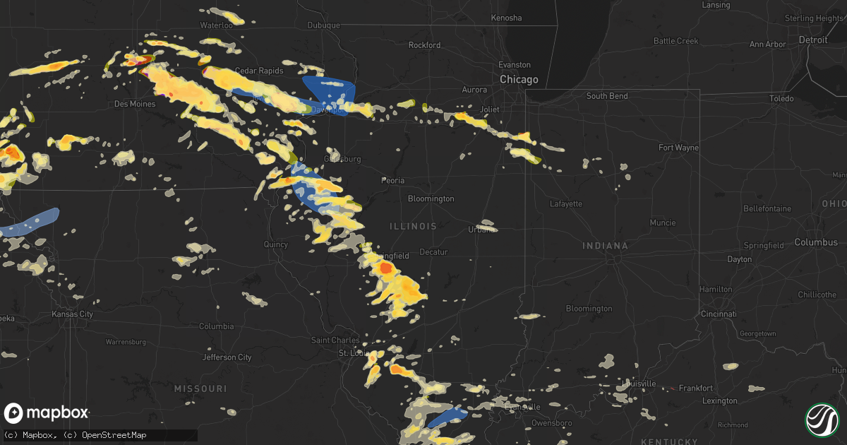
Hail Map in Illinois on May 7, 2023
Get this storm
May 7 map
$229
one time, instant access
Download today. No call, no setup
Keep the $229
Bought the map and want the full workflow? Apply the entire $229 to a subscription within 7 days. None of it is wasted.
Every map, not just this one
This buys you this map. Subscription and you get every map we run, in the markets you choose from a few cities to whole states to nationwide. Plus real-time alerts the moment a storm fires.
Contact data
Name, contact info, occupancy, even credit band for addresses in the footprint. You go from where it hit to who to call.
Become the source they trust
Unlimited branding weather history reports on demand. You already have the documented answer ready for the property owner, and you are the one who showed up with it.
Property data and RoofTrace estimates
Pull up any address you have got, its value and the exact code rules for that jurisdiction, straight from One Click Code. Then RoofTrace estimates the squares, pitch, and roof value, priced the way you price.
Storm reports in Illinois
Illinois
| Date | Description |
|---|---|
| 05/07/20236:58 PM CDT | Report from mping: quarter |
| 05/07/20236:55 PM CDT | A local report indicates 1.00 inch wind near 1 W MACOMB |
| 05/07/20236:49 PM CDT | A local report indicates 1.75 inch wind near 3 SW PRAIRIE CITY |
| 05/07/20236:48 PM CDT | Delayed report. Time estimated from radar. |
| 05/07/20236:44 PM CDT | A local report indicates 1.75 inch wind near 3 NE ATWATER |
| 05/07/20236:43 PM CDT | A local report indicates 1.75 inch wind near RAYMOND |
| 05/07/20236:40 PM CDT | Powerlines downed by thunderstorm winds. Time based on radar and power outage maps. |
| 05/07/20236:40 PM CDT | Efu landspout tornado reported by media. |
| 05/07/20236:34 PM CDT | Report from mping: tennis ball |
| 05/07/20236:30 PM CDT | A local report indicates 2.00 inch wind near GOOD HOPE |
| 05/07/20236:30 PM CDT | Corrects location of previous tornado report from 1 sse sun river terrace. Video shared of landspout-type tornado kicking up dust in a field southwest of route 1 and ro |
| 05/07/20236:30 PM CDT | Video shared of landspout-type tornado kicking up dust in a field near route 1 and route 17 looking southwest. |
| 05/07/20236:22 PM CDT | Report from mping: half dollar |
| 05/07/20236:18 PM CDT | A local report indicates 1.00 inch wind near HILLSBORO |
| 05/07/20236:12 PM CDT | A local report indicates 1.75 inch wind near TAYLOR SPRINGS |
| 05/07/20236:11 PM CDT | A local report indicates 1.00 inch wind near 2 NE BARSTOW |
| 05/07/20236:04 PM CDT | Report from mping: quarter |
| 05/07/20235:53 PM CDT | Mostly smaller hail but one clustered to the size of a golf ball. |
| 05/07/20235:13 PM CDT | Wires down and bank sign damaged due to wind-driven hail. |
| 05/07/20235:13 PM CDT | Wires do |
| 05/07/20235:09 PM CDT | Report from mping: quarter |
| 05/07/20235:03 PM CDT | Report relayed by broadcast media. |
| 05/07/20235:03 PM CDT | Report from mping: baseball |
| 05/07/20235:02 PM CDT | Corrects previous hail report from 1 nne o'fallon. |
| 05/07/20235:02 PM CDT | A local report indicates 1.00 inch wind near 1 NNE O'FALLON |
| 05/07/20234:59 PM CDT | Report from mping: quarter |
| 05/07/20234:57 PM CDT | Near baseball size hail 3 miles nw of nokomis. Social media report with photo on twitter. |
| 05/07/20234:56 PM CDT | A local report indicates 1.00 inch wind near 1 ESE NEW ATHENS |
| 05/07/20234:56 PM CDT | Report from mping: quarter |
| 05/07/20234:52 PM CDT | Report from mping: half dollar |
| 05/07/20234:52 PM CDT | A local report indicates 2.75 inch wind near 3 NW WENONAH |
| 05/07/20234:52 PM CDT | Numerous reports of one inch hail in ofallon... Il. |
| 05/07/20234:48 PM CDT | At the intersection of green mount road and frank scott parkway. |
| 05/07/20234:36 PM CDT | Ping pong size hail. |
| 05/07/20234:35 PM CDT | Quarter size hail measured. |
| 05/07/20234:11 PM CDT | A local report indicates 1.00 inch wind near INDUSTRY |
| 05/07/20234:05 PM CDT | Ping pong size hail at e1100 north road and n300 east road. |
| 05/07/20233:35 PM CDT | Hen egg size hail. Social media report via twitter. Esimated time of report by radar. |
| 05/07/20233:30 PM CDT | Numerous hail stones 2 inch diameter with largest one 2.5 inch. Photo included with ruler. |
| 05/07/20233:25 PM CDT | Report from mping: quarter |
| 05/07/20233:15 PM CDT | Social media report via twitter. |
| 05/07/20233:15 PM CDT | Golf ball size hail in chatham with photo. |
| 05/07/20233:14 PM CDT | Up to 2 inch diameter hail measured. Social media report with photo on twitter. |
| 05/07/20233:10 PM CDT | Social media report via twitter with photo. |
| 05/07/20233:09 PM CDT | Social media report via twitter. |
| 05/07/20233:04 PM CDT | Report from mping: quarter |
| 05/07/20233:04 PM CDT | A local report indicates 1.25 inch wind near CHATHAM |
| 05/07/20233:02 PM CDT | Golf ball size hail in chatham. |
| 05/07/20232:59 PM CDT | Quarter size hail in chatham. |
| 05/07/20232:50 PM CDT | Tree down across hwy 37 north of ina. |
| 05/07/20232:25 PM CDT | Tree limbs down and power outages in the herrin area. |
| 05/07/20232:18 PM CDT | Report from mping: quarter |
| 05/07/20232:10 PM CDT | A local report indicates 1.00 inch wind near MURPHYSBORO |
| 05/07/20232:00 PM CDT | Tree and power line down across old hwy 51. |
| 05/07/20231:40 PM CDT | Gumball sized hail at i-64 and 127. |
| 05/07/20231:00 PM CDT | Corrects previous hail report from okawville. Pictures received on twitter of hail near the size of golf balls. Time estimated. |
| 05/07/20231:00 PM CDT | Pictures received on twitter of hail near the size of golf balls. Time estimated. |
| 05/07/20239:45 AM CDT | Relayed by media. |
| 05/07/20239:25 AM CDT | Time estimated via radar and report relayed by media. |
| 05/07/20239:17 AM CDT | A local report indicates 1.00 inch wind near CARBONDALE |
| 05/07/20236:55 AM CDT | Asos station kmto coles co. Mem ap. |
| 05/06/202310:18 PM CDT | Numerous trees downed in and near piper city... Including one onto a house. Time estimated from radar. |
| 05/06/202310:15 PM CDT | Time estimated. Numerous limbs down... One 4-5 inch diameter limb downed onto a car. |
| 05/06/202310:14 PM CDT | Multiple live trees downed on locust and n 5th street in chatsworth. Time estimated based on radar. |
| 05/06/202310:00 PM CDT | Pontiac comms center relayed tree damage in the town of cullom on route 116. |
| 05/06/20239:57 PM CDT | Multiple power lines down and a damaged shed between saunemin and cullom. Location and time estimated from radar. |
| 05/06/20239:30 PM CDT | Nws employee observed several large tree limbs down throughout lincoln... Including a healthy branch about 3 inches in diameter at the office. |
| 05/06/20239:23 PM CDT | Tree blown down across road at tazewell and madison street. |
| 05/06/20239:20 PM CDT | Powerlines blown down and power pole on fire. |
| 05/06/20239:20 PM CDT | Large tree broken at the base. Time estimated by radar. |
| 05/06/20239:14 PM CDT | Tree blown down on main street in north pekin. |
| 05/06/20239:11 PM CDT | Powerline blown down on second st. |
| 05/06/20239:08 PM CDT | Power pole on fire on winkler road. |
| 05/06/20239:06 PM CDT | Large tree limb blown down on house on derby st. |
| 05/06/20239:00 PM CDT | Barn sustained roof damage and a motorhome was turned on its side. Time estimated from radar. |
| 05/06/20239:00 PM CDT | Station id: fw2710. |
| 05/06/20238:58 PM CDT | Power line blown down on jay street. |
| 05/06/20238:57 PM CDT | Two 2.5 inch measured healthy limbs down. |
| 05/06/20238:57 PM CDT | Multiple hailstones at least quarter sized. Also standing water several inches deep on se frontage road. |
| 05/06/20238:57 PM CDT | Tree blown down across entire road at 9th and sheridan streets. |
| 05/06/20238:55 PM CDT | Tree limbs down - unknown size. |
| 05/06/20238:55 PM CDT | A 16 inch healthy tree limb blown blown down on capitol street. |
| 05/06/20238:54 PM CDT | Large tree blown down on bacon street. |
| 05/06/20238:53 PM CDT | Tree blown down on a house on 13th street. |
| 05/06/20238:52 PM CDT | Power pole leaning over from high winds at colony south apartments at main and idlewood st. |
| 05/06/20238:50 PM CDT | Tree down across a power pole and several branches down. |
| 05/06/20238:50 PM CDT | Large tree limb broken off. |
| 05/06/20238:49 PM CDT | Tree blown down over road at 4th st and park ave. |
| 05/06/20238:48 PM CDT | Corrects previous tstm wnd dmg report from el paso. Several trees blown down in city of el paso and half the city is without power. |
| 05/06/20238:48 PM CDT | Several trees blown down in city of el paso. |
| 05/06/20238:45 PM CDT | Broadcast meteorologist passed along a report from a viewer of roof damage at apartment complex. Radar estimated the time. |
| 05/06/20238:45 PM CDT | Siding damage. |
| 05/06/20238:39 PM CDT | Gust measured at a private weather station. |
| 05/06/20238:36 PM CDT | Report from mping: 1-inch tree limbs broken; shingles blown off. |
| 05/06/20238:35 PM CDT | Reports of multiple road and parking signs bent at nearly 45 degree angles. Time estimated based on radar. |
| 05/06/20238:30 PM CDT | Along north bloomington road... Railroad crossing gates snapped and some trees down. |
| 05/06/20238:29 PM CDT | Unknown size of tree. Tree down across il 116... 2 miles west of farmington - 911 call. |
| 05/06/20238:25 PM CDT | 2 powerlines down with 1 pole leaning. |
| 05/06/20238:24 PM CDT | Trees blown down. |
| 05/06/20238:24 PM CDT | Power lines and large tree limbs downed in and near lostant. Also shingle and siding damage reported to some homes. |
| 05/06/20238:24 PM CDT | Private weather station gusting 55-60 mph for more than 10 minutes. Peak of 62 mph. Winds were just out ahead of the main line of storms. |
| 05/06/20238:20 PM CDT | Report from mping: 1-inch tree limbs broken; shingles blown off. |
| 05/06/20238:20 PM CDT | Several large tree limbs down. Shed thrown about 30 feet. Winds with gust front. Time estimated. |
| 05/06/20238:18 PM CDT | Delayed report and time estimated from radar. Roof damage to a warehouse university dr and bower rd. |
| 05/06/20238:18 PM CDT | Report from mping: 1-inch tree limbs broken; shingles blown off. |
| 05/06/20238:15 PM CDT | Trees blown down. |
| 05/06/20238:15 PM CDT | Two large tree branches down. Time estimated. |
| 05/06/20238:15 PM CDT | A local report indicates 63 MPH wind near MACOMB MUNICIPAL ARPT |
| 05/06/20238:12 PM CDT | A local report indicates 60 MPH wind near 4 W TENNESSEE |
| 05/06/20238:08 PM CDT | Report from mping: quarter |
| 05/06/20238:02 PM CDT | Report of powerlines down on a car with the driver trapped near the west prairie high school. Time estimated by radar. |
| 05/06/20237:59 PM CDT | Estimated 65 mph wind gust with trees down across the county. |
| 05/06/20237:56 PM CDT | Report of tree down in dallas city. Time estimated by radar. |
| 05/06/20237:54 PM CDT | Tree limbs of approx. 6 inch in diameter down in yard. |
| 05/06/20237:39 PM CDT | Report from mping: quarter |
| 05/06/20237:32 PM CDT | Photo shared on social media. Location estimated. Time based on phone timestamp. |
| 05/06/20237:25 PM CDT | Report relayed via local media from viewer. |
| 05/06/20237:20 PM CDT | Reports of trees and powerlines down all across the county. |
| 05/06/20237:09 PM CDT | Landspout. |
| 05/06/20237:07 PM CDT | Social media report. Time estimated from radar. |
| 05/06/20237:05 PM CDT | Also some mping reports of quarter sized hail in macomb. |
| 05/06/20237:05 PM CDT | Golf ball size hail. |
| 05/06/20237:04 PM CDT | A local report indicates 1.00 inch wind near 1 NW MACOMB |
| 05/06/20237:01 PM CDT | Report from mping: quarter |
| 05/06/20237:01 PM CDT | Report from mping: quarter |
| 05/06/20237:00 PM CDT | Relayed by off-duty meteorologist. Time estimated. |
| 05/06/20237:00 PM CDT | Delayed report. Time estimated from radar. |
| 05/06/20237:00 PM CDT | Quarter size hail 2 miles west of blyton. Social media report with photo on twitter. |
| 05/06/20237:00 PM CDT | Corrects previous hail report from marietta. Golf ball size hail relayed by ema. |
All States Impacted by Hail Map on May 7, 2023
Cities Impacted by Hail Map on May 7, 2023
- Perrysville, IN
- Covington, IN
- Williamsport, IN
- Attica, IN
- Shelbyville, KY
- Carbondale, IL
- Tamaroa, IL
- Sesser, IL
- Scheller, IL
- Ozark, IL
- Creal Springs, IL
- New Burnside, IL
- Stonefort, IL
- Gillett, TX
- Corydon, IN
- Leavenworth, IN
- Falls City, TX
- Mulkeytown, IL
- Benton, IL
- Du Quoin, IL
- Floresville, TX
- Cave City, KY
- Evansville, IN
- Elberfeld, IN
- Haubstadt, IN
- Dakota City, NE
- Cotulla, TX
- Henryville, IN
- Sellersburg, IN
- Borden, IN
- Memphis, IN
- Herod, IL
- Eddyville, IL
- George West, TX
- Glasgow, KY
- Crystal City, TX
- La Pryor, TX
- Batesville, TX
- Hubbard, NE
- Utica, KY
- Hartford, KY
- Cynthiana, KY
- Lynnville, IN
- Meadow Grove, NE
- Springerton, IL
- Mill Shoals, IL
- Burnt Prairie, IL
- Carmi, IL
- Enfield, IL
- Pomona, IL
- Murphysboro, IL
- Raleigh, IL
- Harrisburg, IL
- Galatia, IL
- Eckerty, IN
- Lewisport, KY
- Beecher City, IL
- Dale, IN
- Winnebago, NE
- Jasper, IN
- Philpot, KY
- New Salisbury, IN
- Georgetown, IN
- Brooks, KY
- Louisville, KY
- Fairdale, KY
- Oakland, IL
- Shepherdsville, KY
- Elizabeth, IN
- West Point, KY
- Golden Gate, IL
- Ellery, IL
- Nortonville, KY
- White Plains, KY
- Owensville, IN
- Princeton, IN
- Yorktown, TX
- Lebanon Junction, KY
- Bardstown, KY
- Boston, KY
- Coxs Creek, KY
- Clermont, KY
- Mount Vernon, IN
- Earlington, KY
- Mortons Gap, KY
- Dawson Springs, KY
- Madisonville, KY
- Guthrie Center, IA
- Sharpsburg, KY
- Owingsville, KY
- Makanda, IL
- New Albany, IN
- Dixon, KY
- Buckner, IL
- Logan, IL
- Christopher, IL
- West Frankfort, IL
- Thompsonville, IL
- Waverly, OH
- Beaver, OH
- Gentryville, IN
- Stendal, IN
- Boonville, IN
- Holland, IN
- Tennyson, IN
- Nordheim, TX
- Cuero, TX
- New Middletown, IN
- Lanesville, IN
- Laconia, IN
- Brandenburg, KY
- Campbellsburg, IN
- Salem, IN
- Newburgh, IN
- Sigel, IL
- Neoga, IL
- Leitchfield, KY
- Brownsville, KY
- Roundhill, KY
- Caneyville, KY
- Bee Spring, KY
- English, IN
- Berry, KY
- Karnes City, TX
- Runge, TX
- Milltown, IN
- Depauw, IN
- Whitesville, KY
- Taswell, IN
- Urbana, IL
- Saint Joseph, IL
- Champaign, IL
- Rockport, IN
- Chrisney, IN
- Grandview, IN
- Morgantown, KY
- Sweeden, KY
- Graham, KY
- Bremen, KY
- Springfield, KY
- Broughton, IL
- Norris City, IL
- Mauckport, IN
- Greenville, KY
- Sacramento, KY
- Goreville, IL
- Winslow, IN
- Hanson, KY
- Providence, KY
- Princeton, KY
- Saint Charles, KY
- Nebo, KY
- Manitou, KY
- Ogden, IL
- Horse Branch, KY
- Slaughters, KY
- McLeansboro, IL
- Dale, IL
- Macedonia, IL
- Orient, IL
- Kenedy, TX
- Beeville, TX
- Dahlgren, IL
- Paoli, IN
- Pekin, IN
- Hardinsburg, IN
- Fredericksburg, IN
- Thomasboro, IL
- Marion, IL
- Mount Sterling, KY
- Carlisle, KY
- Paris, KY
- Drakesboro, KY
- Poth, TX
- Simpson, IL
- Elizabethtown, IL
- Panora, IA
- Sebree, KY
- Wadesville, IN
- New Harmony, IN
- Finchville, KY
- Richland, IN
- Omaha, IL
- Ridgway, IL
- Campbellton, TX
- Dow City, IA
- Arion, IA
- Denison, IA
- Simpsonville, KY
- Chandler, IN
- Stewardson, IL
- Three Rivers, TX
- Tuscola, IL
- Manning, IA
- Westside, IA
- Arcadia, IA
- Carroll, IA
- Halbur, IA
- Glidden, IA
- Addieville, IL
- Okawville, IL
- Nashville, IL
- Hoyleton, IL
- Golconda, IL
- Smithland, KY
- Hampton, KY
- Manilla, IA
- Vail, IA
- Rosiclare, IL
- Sharon, TN
- Dresden, TN
- Greenfield, TN
- Gleason, TN
- Waverly, IL
- Loami, IL
- Chatham, IL
- Energy, IL
- Carterville, IL
- Johnston City, IL
- Herrin, IL
- Pittsburg, IL
- Bonnie, IL
- Mount Vernon, IL
- Waltonville, IL
- Opdyke, IL
- Dunning, NE
- Henry, TN
- McKenzie, TN
- Paris, TN
- Belle Rive, IL
- Eldorado, IL
- Auburn, IL
- Springfield, IL
- Purdum, NE
- Glenarm, IL
- Divernon, IL
- Pawnee, IL
- Boone, IA
- Ames, IA
- Gilbert, IA
- Nevada, IA
- Story City, IA
- Virden, IL
- Roland, IA
- Zearing, IA
- McCallsburg, IA
- Cambridge, IA
- Maxwell, IA
- Collins, IA
- Colo, IA
- Mingo, IA
- Baxter, IA
- Rhodes, IA
- State Center, IA
- Melbourne, IA
- Toledo, IA
- Clutier, IA
- Tama, IA
- Chelsea, IA
- Vining, IA
- Elberon, IA
- Morrisonville, IL
- Roscoe, TX
- Clarksville, TN
- Oak Grove, KY
- Colfax, IA
- Trenton, KY
- Newton, IA
- Sweetwater, TX
- Roby, TX
- Oliver Springs, TN
- Briceville, TN
- Powell, TN
- Clinton, TN
- Heiskell, TN
- Hopkinsville, KY
- Herndon, KY
- Cadiz, KY
- Rowena, TX
- Miles, TX
- Ira, IA
- Ballinger, TX
- Haverhill, IA
- Laurel, IA
- Idalia, CO
- Burlington, CO
- Kanorado, KS
- Goodland, KS
- Mereta, TX
- Charleston, MO
- New Berlin, IL
- Industry, IL
- Adair, IL
- Belle Plaine, IA
- Vermont, IL
- Hartwick, IA
- Victor, IA
- Marengo, IA
- Knoxville, TN
- Van Horne, IA
- Luzerne, IA
- Ladora, IA
- Blairstown, IA
- Keystone, IA
- Haigler, NE
- Rotan, TX
- Wray, CO
- Hamlin, TX
- Grinnell, IA
- Gilman, IA
- Kellogg, IA
- Palmer, IL
- Nokomis, IL
- Lynnville, IA
- Rushville, IL
- Bird City, KS
- Wickliffe, KY
- Barlow, KY
- Snyder, TX
- Searsboro, IA
- Montezuma, IA
- Malcom, IA
- Seymour, TX
- Guthrie, KY
- Allensville, KY
- Elkton, KY
- Olmstead, KY
- Russellville, KY
- La Center, KY
- Rosamond, IL
- Winters, TX
- Edson, KS
- McDonald, KS
- Aspermont, TX
- Middle Amana, IA
- Amana, IA
- Watkins, IA
- Norway, IA
- Fort Madison, IA
- West Point, IA
- Alzada, MT
- Wever, IA
- Hulett, WY
- Astoria, IL
- Ipava, IL
- Adairville, KY
- Brooklyn, IA
- Kevil, KY
- Barnes City, IA
- Williamsburg, IA
- Conroy, IA
- South Amana, IA
- Tiffin, IA
- Oxford, IA
- Homestead, IA
- Iowa City, IA
- Coralville, IA
- Swisher, IA
- North Liberty, IA
- Sylvester, TX
- Ohlman, IL
- Pana, IL
- Oconee, IL
- Fairfax, IA
- Auburn, KY
- Franklin, KY
- Alexander, IL
- Guernsey, IA
- Gibson, IA
- Deep River, IA
- Pleasant Plains, IL
- Ashland, IL
- Mansfield, TN
- Pella, IA
- Springville, TN
- Sully, IA
- Levant, KS
- Colby, KS
- Brewster, KS
- New Sharon, IA
- Atwood, KS
- Browning, IL
- Havana, IL
- Kilbourne, IL
- Bath, IL
- Chandlerville, IL
- Benjamin, TX
- Cumberland Furnace, TN
- Vanleer, TN
- Ovalo, TX
- Solon, IA
- Boaz, KY
- Hickory, KY
- Sedalia, KY
- Tallula, IL
- Tuscola, TX
- Charlotte, TN
- Wellman, IA
- North English, IA
- Parnell, IA
- Keswick, IA
- Webster, IA
- Buffalo Gap, TX
- Oskaloosa, IA
- Rose Hill, IA
- Burlington, IA
- West Paducah, KY
- Lone Tree, IA
- Wingate, TX
- West Branch, IA
- Belleville, IL
- O'Fallon, IL
- Merkel, TX
- Abilene, TX
- Tye, TX
- Waverly, TN
- McEwen, TN
- Erin, TN
- Rapid City, SD
- Lebanon, IL
- What Cheer, IA
- Delta, IA
- Gracey, KY
- New Athens, IL
- West Liberty, IA
- Atalissa, IA
- Tipton, IA
- White Bluff, TN
- Kalona, IA
- Ellsworth Afb, SD
- Box Elder, SD
- Selden, KS
- Dickson, TN
- McCaulley, TX
- Anson, TX
- Kingston Springs, TN
- Aladdin, WY
- Sigourney, IA
- Riverside, IA
- Harper, IA
- Hills, IA
- Keota, IA
- South English, IA
- Dresden, KS
- Hawley, TX
- Trent, TX
- Hayesville, IA
- Carman, IL
- Stronghurst, IL
- Lomax, IL
- Almo, KY
- Hardin, KY
- Benton, KY
- Media, IL
- Raritan, IL
- Ollie, IA
- Kirksey, KY
- Murray, KY
- Roseville, IL
- Smithshire, IL
- Villa Ridge, IL
- Dexter, KY
- Paint Rock, TX
- Nichols, IA
- Muscatine, IA
- Moscow, IA
- Wilton, IA
- Jennings, KS
- Oberlin, KS
- Freeburg, IL
- Durant, IA
- Blue Grass, IA
- Stockton, IA
- New Underwood, SD
- Port Byron, IL
- Hillsdale, IL
- Hillsboro, IL
- Butler, IL
- Clayton, KS
- Lenora, KS
- Morland, KS
- Eola, TX
- San Angelo, TX
- Irving, IL
- Coon Rapids, IA
- Jewell, IA
- Randall, IA
- Jefferson, IA
- Churdan, IA
- Scranton, IA
- Red Bud, IL
- Marine, IL
- Edwardsville, IL
- Metropolis, IL
- Pocahontas, IL
- Radcliffe, IA
- Sullivan, IN
- Taylorville, IL
- Big Rock, TN
- La Fayette, KY
- Stanhope, IA
- Vienna, IL
- Caryville, TN
- Highland, IL
- Trenton, IL
- Aviston, IL
- Breese, IL
- Russellville, TN
- Salem, KY
- Marion, KY
- Breda, IA
- Tallulah, LA
- Richview, IL
- Ashley, IL
- Farmersville, IL
- Bardwell, KY
- Louisville, IL
- Calvert City, KY
- Symsonia, KY
- Paducah, KY
- Carlyle, IL
- Maryville, IL
- Granite City, IL
- Collinsville, IL
- Audubon, IA
- Dukedom, TN
- Fulton, KY
- Odin, IL
- Salem, IL
- Macomb, IL
- Marshalltown, IA
- Lewisburg, KY
- Centralia, IL
- Whitesburg, TN
- Morristown, TN
- Crowell, TX
- Kinmundy, IL
- Fairview Heights, IL
- Scott Air Force Base, IL
- South Fulton, TN
- Martin, TN
- Eddyville, KY
- Lake City, IA
- Hammond, MT
- Lenzburg, IL
- Jefferson City, TN
- De Soto, IL
- Alto Pass, IL
- Cambria, IL
- Wolf Lake, IL
- Pembroke, KY
- Melber, KY
- Cunningham, KY
- Talbott, TN
- White Pine, TN
- Dandridge, TN
- New Market, TN
- Newport, TN
- Fredonia, KY
- Du Bois, IL
- Ina, IL
- Kuttawa, KY
- Scottsville, KY
- Bean Station, TN
- Oakdale, IL
- Mohawk, TN
- Rives, TN
- Pulaski, IL
- Grand Chain, IL
- Karnak, IL
- Mayfield, KY
- Mounds, IL
- Ullin, IL
- Olmsted, IL
- Beech Creek, KY
- Belton, KY
- Dunmor, KY
- New Baden, IL
- Alva, WY
- Palmyra, TN
- Cumberland City, TN
- Fort Campbell, KY
- Wartburg, TN
- Elkville, IL
- Xenia, IL
- Farina, IL
- Crofton, KY
- Vergennes, IL
- Ralston, IA
- Gilbertsville, KY
- Crossville, IL
- Walshville, IL
- Litchfield, IL
- Thorn Hill, TN
- Saint Francis, KS
- Stewart, TN
- Tennessee Ridge, TN
- Big Sandy, TN
- Hurst, IL
- Royalton, IL
- Saint Jacob, IL
- Seneca, NE
- Thedford, NE
- Halsey, NE
- Hermleigh, TX
- Huntsville, TN
- Rocky Top, TN
- Jonesboro, IL
- Orlinda, TN
- Springfield, TN
- Buncombe, IL
- Dongola, IL
- Woodlawn, IL
- Carrier Mills, IL
- Equality, IL
- Zeigler, IL
- Ava, IL
- Dowell, IL
- Belknap, IL
- Cobden, IL
- Cypress, IL
- Anna, IL
- Jamestown, TN
- Deer Lodge, TN
- Millstadt, IL
- Grand Rivers, KY
- Miller City, IL
- Thebes, IL
- Taylor Springs, IL
- Robards, KY
- Tamms, IL
- Pinckneyville, IL
- New Haven, IL
- Pine Bluff, AR
- Midkiff, TX
- Merom, IN
- Mascoutah, IL
- Pegram, TN
- Nashville, TN
- Franklin, TN
- Brentwood, TN
- Coffeen, IL
- Big Lake, TX
- Garden City, TX
- Raymond, IL
- Nilwood, IL
- Waggoner, IL
- Carlinville, IL
- Washington, IA
- Wayland, IA
- Richland, IA
- Fairfield, IA
- Brighton, IA
- Colona, IL
- Geneseo, IL
- Antioch, TN
- Ozona, TX
- Iraan, TX
- Prophetstown, IL
- Hooppole, IL
- Walcott, IA
- Davenport, IA
- Hill City, KS
- Penokee, KS
- Wheatland, IA
- Lost Nation, IA
- Lowden, IA
- Grand Mound, IA
- Bennett, IA
- Donahue, IA
- Dixon, IA
- Calamus, IA
- New Liberty, IA
- Long Grove, IA
- Goose Lake, IA
- De Witt, IA
- Delmar, IA
- Norcatur, KS
- Eldridge, IA
- Moline, IL
- McCausland, IA
- Rock Island, IL
- Princeton, IA
- Camanche, IA
- Bettendorf, IA
- Le Claire, IA
- Clinton, IA
- Coal Valley, IL
- Hampton, IL
- Carbon Cliff, IL
- Low Moor, IA
- Pleasant Valley, IA
- East Moline, IL
- Silvis, IL
- Cordova, IL
- Rapids City, IL
- Harvel, IL
- Packwood, IA
- Winfield, IA
- Mount Pleasant, IA
- Mount Union, IA
- Yarmouth, IA
- Good Hope, IL
- Avon, IL
- Prairie City, IL
- Bushnell, IL
- Colchester, IL
- Owanka, SD
- Annawan, IL
- Bogue, KS
- Albany, IL
- Erie, IL
- Fulton, IL
- Kensington, KS
- Smith Center, KS
- Belleville, KS
- Scandia, KS
- Mankato, KS
- Esbon, KS
- Logan, KS
- Gaylord, KS
- Kirwin, KS
- Courtland, KS
- Phillipsburg, KS
- Athol, KS
- Lebanon, KS
- Glade, KS
- Prairie View, KS
- Cuba, KS
- Grant Park, IL
- Momence, IL
- Morning Sun, IA
- Narka, KS
- Mahaska, KS
- Mediapolis, IA
- Haddam, KS
- Schneider, IN
- Lowell, IN
- Stockton, KS
- Hebron, NE
- Newark, IL
- Gilead, NE
- Alexandria, NE
- Belvidere, NE
- Daykin, NE
- Tobias, NE
- Unadilla, NE
- Burr, NE
- Syracuse, NE
- Mendota, IL
- Fairbury, NE
- Sublette, IL
- La Moille, IL
- Ohio, IL
- Amboy, IL
- Sciota, IL
- Bardolph, IL
- Pacific Junction, IA
- Plattsmouth, NE
- Glenwood, IA
- Mount Sterling, IL
- Malvern, IA
- Morrowville, KS
- New London, IA
- Sperry, IA
- Washington, KS
- Table Grove, IL
- Marietta, IL
- Otoe, NE
- Dunbar, NE
- Woodston, KS
- Morris, IL
- Seneca, IL
- Wasta, SD
- Wall, SD
- Endicott, NE
- Hollenberg, KS
- Clyde, KS
- Clifton, KS
- Palmer, KS
- Avoca, NE
- Nehawka, NE
- Western, NE
- Smithfield, IL
- Cuba, IL
- Jansen, NE
- Knox City, TX
- Munday, TX
- Biggsville, IL
- Gladstone, IL
- Lewistown, IL
- Alton, KS
- Tabor, IA
- Hastings, IA
- Linn, KS
- Diller, NE
- Hanover, KS
- Adams, NE
- Plymouth, NE
- Douglas, NE
- Palmyra, NE
- Firth, NE
- Nebraska City, NE
- Weeping Water, NE
- Murray, NE
- Osborne, KS
- Portis, KS
- Corning, IA
- Bridgewater, IA
- Prescott, IA
- Fontanelle, IA
- Massena, IA
- Orient, IA
- Belle Fourche, SD
- Clinton, KY
- Villisca, IA
- Nisland, SD
- Newell, SD
- Cumberland, IA
- Emerson, IA
- Sterling, NE
- Cook, NE
- Talmage, NE
- Lorton, NE
- Downs, KS
- Greenleaf, KS
- Percival, IA
- Thurman, IA
- Union, NE
- Odell, NE
- Bremen, KS
- Marysville, KS
- Cawker City, KS
- Steele City, NE
- Blue Springs, NE
- Wymore, NE
- Dallas City, IL
- Blandinsville, IL
- Carthage, IL
- La Harpe, IL
- West Burlington, IA
- Barnes, KS
- Tennessee, IL
- Glen Elder, KS
- Milford, NE
- Pleasant Dale, NE
- Lincoln, NE
- Denton, NE
- Quinn, SD
- Malcolm, NE
- Philip, SD
- Raymond, NE
- Davey, NE
- Ceresco, NE
- Sturgis, SD
- Whitewood, SD
- Vale, SD
- Seward, NE
- Garland, NE
- Oketo, KS
- Creston, IA
- Beloit, KS
- Waterville, KS
- Stanton, IA
- Red Oak, IA
- Wilmington, IL
- Channahon, IL
- Coal City, IL
- Elwood, IL
- Silver City, IA
- Mineola, IA
- Plymouth, IL
- Sidney, IA
- Hamburg, IA
- Liberty, NE
- Barneston, NE
- Beattie, KS
- Tecumseh, NE
- Brock, NE
- Johnson, NE
- Peru, NE
- Julian, NE
- Waverly, NE
- Home, KS
- Summerfield, KS
- Burchard, NE
- Riverton, IA
- Rock Port, MO
- Farragut, IA
- Superior, NE
- Webber, KS
- Hardy, NE
- Clyde, TX
- Hubbard, IA
- New Providence, IA
- Union, IA
- Eldora, IA
- Pembroke Township, IL
- Saint Anne, IL
- Beaverville, IL
- Morocco, IN
- Palo Pinto, TX
- Brook, IN
- Graford, TX
- Mineral Wells, TX
- Guntown, MS
- Baldwyn, MS
- Pawnee City, NE
- Oakland, IA
- Booneville, MS
- Marietta, MS
- Walnut, IA
- Avoca, IA
- Hancock, IA
- Mount Ayr, IN
- Whitten, IA
- Conrad, IA
- Fairbank, IA
- Dunkerton, IA
- Jesup, IA
- Independence, IA
- Hazleton, IA
- Hudson, IA
- La Porte City, IA
- Waterloo, IA
- Buckingham, IA
- Dyess Afb, TX
- Council Bluffs, IA
- McClelland, IA
- Underwood, IA
- Beaman, IA
- Baird, TX
- Liscomb, IA
- Ogden, IA
- Republic, KS
- Ruskin, NE
- Nelson, NE
- Byron, NE
- Hubbell, NE
- Deshler, NE
- Munden, KS
- Chester, NE
- Reynolds, NE
- Dawson, NE
- Salem, NE
- Verdon, NE
- Falls City, NE
- Neola, IA
- Minden, IA
- Craig, MO
- Rulo, NE
- Gladbrook, IA
- Shelby, IA
- Trezevant, TN
- Huntingdon, TN
- Riley, KS
- Manhattan, KS
- Beatrice, NE
- Saint George, KS
- Osceola, IA
- Mound City, MO
- Maitland, MO
- Skidmore, MO
- Weldon, IA
- Woodburn, IA
- Filley, NE
- Graham, MO
- Barnard, MO
- Maryville, MO
- Conception Junction, MO
- Virginia, NE
- Wamego, KS
- Kokomo, IN
- Bunker Hill, IN
- Sheffield, IL
- Manlius, IL
- Piedmont, SD
- Middletown, IA
- Danville, IA
- La Salle, IL
- Peru, IL
- Alma, IL
- Ethel, MS
- Van Orin, IL
- Walnut, IL
- Caseyville, IL
- White Hall, AR
- Saint Onge, SD
- Spearfish, SD
- Bruning, NE
- Humboldt, NE
- Ramsey, IL
- Fillmore, IL
- Mulberry Grove, IL
- West Point, IL
- Bowen, IL
- Hillsboro, TN
- Morrison, TN
- Lake Village, IN
- Dover, TN
- Indian Mound, TN
- Beardstown, IL
- Virginia, IL
- Arenzville, IL
- Meredosia, IL
- Castalian Springs, TN
- Gallatin, TN
- Alexis, IL
- Niota, IL
- Saint Anthony, IA
- Clemons, IA
- Kirkwood, IL
- Carlisle, AR
- Norton, KS
- Lexington, MS
- Benton, MS
- Yazoo City, MS
- Blue Rapids, KS
- Kankakee, IL
- Aroma Park, IL
- Donnellson, IA
- Girard, IL
- Palmyra, IL
- Vicksburg, MS
- Atkinson, IL
- Weinert, TX
- Goree, TX
- Mertzon, TX
- Burnettsville, IN
- Royal Center, IN
- Frankfort, KS
- Auburn, NE
- Farmington, KY
- Spencer, TN
- Timewell, IL
- Bentonia, MS
- Robinson, IL
- Wakefield, KS
- Milford, KS
- Clay Center, KS
- Leonardville, KS
- Sheridan, IL
- Ottawa, IL
- Aledo, IL
- Seaton, IL
- Belzoni, MS
- Altheimer, AR
- Essex, IA
- Shenandoah, IA
- Imogene, IA
- Carson, IA
- Treynor, IA
- Jacksonville, IL
- Concord, IL
- Iuka, MS
- Hedrick, IA
- Manteno, IL
- Corning, KS
- Centralia, KS
- Traer, IA
- Owaneco, IL
- Bingham, IL
- Palmersville, TN
- Utica, MS
- Crystal Springs, MS
- Hazlehurst, MS
- Sherrill, AR
- Illinois City, IL
- New Boston, IL
- Yorkville, IL
- Junction City, KS
- Fort Riley, KS
- Saltillo, MS
- Coin, IA
- Henderson, IA
- Yorktown, IA
- Clarinda, IA
- Randolph, IA
- Elvaston, IL
- Warsaw, IL
- Basco, IL
- Modesto, IL
- Long Island, KS
- Fruitland, IA
- Letts, IA
- Joy, IL
- Manchester, TN
- Beechgrove, TN
- Bradyville, TN
- Tracy City, TN
- Whitwell, TN
- Gerlaw, IL
- Sunset, SC
- Fayetteville, TN
- Woodbury, TN
- Carleton, NE
- Cedar Rapids, IA
- Hermanville, MS
- Wabash, IN
- Peru, IN
- Denver, IN
- O'Brien, TX
- Columbus Junction, IA
- Wapello, IA
- Guide Rock, NE
- Seneca, KS
- Bern, KS
- Bourbonnais, IL
- Rock Island, TN
- Fair Oaks, IN
- Gillespie, IL
- Bunker Hill, IL
- Wabbaseka, AR
- Humphrey, AR
- Camden, IL
- Table Rock, NE
- Readyville, TN
- Sorento, IL
- Doyle, TN
- Pikeville, TN
- Quebeck, TN
- Baileyville, KS
- Axtell, KS
- Du Bois, NE
- Steinauer, NE
- Lockridge, IA
- Bartelso, IL
- Vaughan, MS
- Pickens, MS
- Christiana, TN
- Murfreesboro, TN
- Burns, TN
- Cunningham, TN
- Fairview, TN
- Nolensville, TN
- Morrill, KS
- Sabetha, KS
- Mount Olive, IL
- Rochester, IL
- Witt, IL
- New Douglas, IL
- Thayer, IL
- Franklin, IL
- Benld, IL
- Mcminnville, TN
- Rochester, TX
- Rule, TX
- Agra, KS
- Nemaha, NE
- Altamont, TN
- Beersheba Springs, TN
- Brookport, IL
- New Bedford, IL
- Tampico, IL
- Coalmont, TN
- Grandview, IA
- East Prairie, MO
- Summerfield, IL
- Smithville, TN
- Old Glory, TX
- Oxford Junction, IA
- Clarence, IA
- Griswold, IA
- Galesburg, IL
- Cameron, IL
- Monmouth, IL
- Rensselaer, IN
- Crawfordsville, IA
- Olds, IA
- Logansport, IN
- Jamaica, IA
- Yale, IA
- Rippey, IA
- Bagley, IA
- Vermillion, KS
- Kewanna, IN
- Wedron, IL
- Serena, IL
- Marseilles, IL
- Almena, KS
- Frankewing, TN
- Cornersville, TN
- Petersburg, TN
- Pulaski, TN
- Hartsville, TN
- Dwight, IL
- Emington, IL
- Odell, IL
- Earlville, IL
- Walling, TN
- Papineau, IL
- Martinton, IL
- Princeton, IL
- Medaryville, IN
- Francesville, IN
- Wheatfield, IN
- Caddo, TX
- Breckenridge, TX
- Chaffee, MO
- Scott City, MO
- Dellrose, TN
- Woodward, IA
- Granger, IA
- Chillicothe, TX
- Glen Carbon, IL
- Lonoke, AR
- England, AR
- Idaville, IN
- Star City, IN
- Joliet, IL
- Taylor Ridge, IL
- Flora, MS
- Palestine, IL
- Parsons, TN
- Arlington, KY
- Minooka, IL
- Demotte, IN
- Troy, IL
- Fancy Farm, KY
- Burna, KY
- Utica, IL
- Linden, TN
- Michie, TN
- Peotone, IL
- Ashland City, TN
- Madrid, IA
- Centerville, IA
- Seymour, IA
- Vinton, IA
- Rowley, IA
- Ellsworth, IA
- Afton, IA
- Thayer, IA
- Ottumwa, IA
- Eddyville, IA
- Chillicothe, IA
- Kirkville, IA
- Huntsville, IL
- Slater, IA
- Alden, IA
- Argyle, IA
- Farmington, IA
- Kahoka, MO
- Wayland, MO
- Lawrenceburg, TN
- Collinwood, TN
- Waynesboro, TN
- Lutts, TN
- Cypress Inn, TN
- Loraine, IL
- Anamosa, IA
- Wyoming, IA
- Center Junction, IA
- Olin, IA
- Martelle, IA
- Everest, KS
- Lancaster, KS
- Denton, KS
- Wathena, KS
- Troy, KS
- Janesville, IA
- Waverly, IA
- North Henderson, IL
- Carrizo Springs, TX
- Wilsonville, IL
- Wolcott, IN
- Polk City, IA
- Harlan, IA
- Vassar, KS
- Lyndon, KS
- Quenemo, KS
- Perry, IA
- King City, MO
- Denver, IA
- Readlyn, IA
- Cedar Falls, IA
- Burnsville, MS
- Nauvoo, IL
- Grundy Center, IA
- Brownville, NE
- Promise City, IA
- Corydon, IA
- Wilsey, KS
- Osage City, KS
- Burlingame, KS
- Green Castle, MO
- Novinger, MO
- Garwin, IA
- Dysart, IA
- Chapman, KS
- Alta Vista, KS
- Abilene, KS
- Dwight, KS
- Enterprise, KS
- Alma, KS
- Weston, MO
- Lineville, IA
- Garden Grove, IA
- Reinbeck, IA
- Lorimor, IA
- Macksburg, IA
- Kelley, IA
- Garrison, IA
- Mount Auburn, IA
- Oelwein, IA
- Baldwin, IA
- Maquoketa, IA
- Murray, IA
- Panama, IL
- Donnellson, IL
- Faucett, MO
- Saint Joseph, MO
- De Kalb, MO
- Cromwell, IA
- Germantown, IL
- Humeston, IA
- Chariton, IA
- Derby, IA
- Dearborn, MO
- Wyaconda, MO
- Manhattan, IL
- Unionville, MO
- Highland, KS
- White Cloud, KS
- Robinson, KS
- Council Grove, KS
- Shell Rock, IA
- Manley, NE
- Louisville, NE
- Murdock, NE
- Topeka, KS
- Paxico, KS
- Olsburg, KS
- McFarland, KS
- Belvue, KS
- Maple Hill, KS
- Ellston, IA
- Shannon City, IA
- Tingley, IA
- Fairview, KS
- Goff, KS
- Wetmore, KS
- Strawn, TX
- Comstock, TX
- Sparland, IL
- Oregon, MO
- Fillmore, MO
- Hiawatha, KS
- Bendena, KS
- Atchison, KS
- Abingdon, IL
- Rushville, MO
- Peoria, IL
- Hanna City, IL
- Gardner, IL
- Triumph, IL
- Linton, IN
- Dugger, IN
- Greenville, IL
- Arlington, IL
- Cherry, IL
- Chapin, IL
- May, TX
- New Virginia, IA
- Horton, KS
- Cincinnati, IA
- Ashkum, IL
- Bussey, IA
- Brookfield, MO
- Van Wert, IA
- Grand River, IA
- Augusta, IL
- Allen, KS
- Truro, IA
- Rea, MO
- New Boston, MO
- Ethel, MO
- Elk Creek, NE
- Remington, IN
- Smithville, MO
- Edgerton, MO
- Trimble, MO
- Winthrop, IA
- Aurora, IA
- Shipman, IL
- Paducah, TX
- Watson, MO
- Kirkman, IA
- Camden Point, MO
- Platte City, MO
- Wyanet, IL
- Leon, IA
- Eureka, IL
- Edinburg, IL
- Nodaway, IA
- Lovilia, IA
- Hamilton, IA
- Powhattan, KS
- White City, KS
- Oneida, KS
- Iowa Falls, IA
- Frederick, IL
- Hettick, IL
- Holladay, TN
- Sugar Tree, TN
- Lueders, TX
- Kirksville, MO
- Cottage Grove, TN
- Albia, IA
- Albers, IL
- Norton, TX
- Counce, TN
- Bowling Green, KY
- Rockfield, KY
- Mendon, MO
- Keytesville, MO
- Saint Robert, MO
- Dixon, MO
- Newburg, MO
- Nebo, IL
- Elmer, MO
- Saint Paul, IA
- Jacksonville, MO
- Macon, MO
- Excello, MO
- Huntsville, MO
- Callao, MO
- Atlanta, MO
- Bevier, MO
- Crocker, MO
- Iron City, TN
- Sturgeon, MO
- Moweaqua, IL
- Clayton, IL
- Baylis, IL
- Scranton, KS
- Powderly, KY
- Marceline, MO
- Bucklin, MO
- New Cambria, MO
- Excelsior Springs, MO
- Orrick, MO
- Pomona, KS
- Ottawa, KS
- Cerulean, KY
- Anabel, MO
- California, MO
- Centertown, MO
- Salisbury, MO
- Kansas City, MO
- Kearney, MO
- Liberty, MO
- Rush Hill, MO
- Mexico, MO
- Santa Fe, MO
- Laddonia, MO
- Farber, MO
- Vandalia, MO
- Jayton, TX
- East Saint Louis, IL
- Nevada, MO
- Clifton Hill, MO
- Saint Augustine, IL
- Ainsworth, IA
- Clarksville, MO
- Salem, IA
- Staunton, IL
- Louisburg, MO
- Hamilton, IL
- Assumption, IL
- Camdenton, MO
- Berwick, IL
- Kewanee, IL
- Central City, KY
- Linn Creek, MO
- Clarence, MO
- Petersburg, IL
- Rising Star, TX
- Monroe, IA


