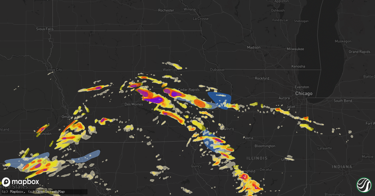
Hail Map on May 7, 2023
Get this storm
May 7 map
$229
one time, instant access
Download today. No call, no setup
Keep the $229
Bought the map and want the full workflow? Apply the entire $229 to a subscription within 7 days. None of it is wasted.
Every map, not just this one
This buys you this map. Subscription and you get every map we run, in the markets you choose from a few cities to whole states to nationwide. Plus real-time alerts the moment a storm fires.
Contact data
Name, contact info, occupancy, even credit band for addresses in the footprint. You go from where it hit to who to call.
Become the source they trust
Unlimited branding weather history reports on demand. You already have the documented answer ready for the property owner, and you are the one who showed up with it.
Property data and RoofTrace estimates
Pull up any address you have got, its value and the exact code rules for that jurisdiction, straight from One Click Code. Then RoofTrace estimates the squares, pitch, and roof value, priced the way you price.
States Impacted by Hail Map on May 7, 2023
Storm reports
Mississippi
| Date | Description |
|---|---|
| 05/07/20236:53 PM CDT | Tree reported down via law enforcement. |
| 05/07/20236:50 PM CDT | Powerlines reported down. Reported by social media. |
| 05/07/20236:39 PM CDT | Tree reported down on e gallman rd. |
| 05/07/20235:09 PM CDT | Tree fallen on home. No injuries reported. |
| 05/07/20235:07 PM CDT | Tree fell down on home. No reported injuries. |
| 05/06/20239:16 PM CDT | A local report indicates 1.00 inch wind near PRATTS FRIENDSHIP |
South Dakota
| Date | Description |
|---|---|
| 05/07/20236:45 PM CDT | Lasted around 15 minutes |
| 05/07/20236:42 PM CDT | Time estimated from radar. |
| 05/07/20236:03 PM CDT | A local report indicates 1.00 inch wind near 2 ENE ELLSWORTH AFB |
| 05/07/20236:02 PM CDT | A local report indicates 1.00 inch wind near 2 E ELLSWORTH AFB |
| 05/07/20236:00 PM CDT | A local report indicates 1.25 inch wind near 2 E ELLSWORTH AFB |
| 05/07/20235:52 PM CDT | Delayed report. Time estimated from radar. |
| 05/07/20235:48 PM CDT | Pictures show at least ping pong ball sized hail. Time estimated from radar. |
| 05/07/20235:46 PM CDT | A local report indicates 1.50 inch wind near 4 WNW BOX ELDER |
| 05/06/20237:59 PM CDT | A local report indicates 58 MPH wind near 1 N BUFFALO |
| 05/06/20237:55 PM CDT | Time estimated from radar. |
| 05/06/20237:44 PM CDT | A local report indicates 1.00 inch wind near NISLAND |
| 05/06/20237:35 PM CDT | Time estimated from radar. |
| 05/06/20237:10 PM CDT | Time estimated from radar. |
| 05/06/20237:05 PM CDT | Image shows several hailstones near the size of quarters. Time estimated from radar. |
Kentucky
| Date | Description |
|---|---|
| 05/07/20236:15 PM CDT | Report from mping: quarter |
| 05/07/20236:15 PM CDT | Report received via social media. |
| 05/07/20236:12 PM CDT | A local report indicates 1.00 inch wind near BANDANA |
| 05/07/20235:51 PM CDT | Photo of roughly 2.25 inch hail from southwestern marshall co.... Ky. |
| 05/07/20235:19 PM CDT | Several trees and power lines down in the franklin area. Time estimated from radar. |
| 05/07/20235:15 PM CDT | Along childress road in far west mccracken county. |
| 05/07/20235:10 PM CDT | Several trees down in the gage area. Near intersection of gage road and hwy 286. |
| 05/07/20234:46 PM CDT | Tree down over the road at 180 lickskillet rd. Time estimated from radar. |
| 05/07/20234:45 PM CDT | A local report indicates 1.00 inch wind near WICKLIFFE |
| 05/07/20234:43 PM CDT | Tree down over the road at 600 paul young rd. Time estimated from radar. |
| 05/07/20234:10 PM CDT | A local report indicates 1.75 inch wind near HERNDON |
| 05/07/20233:45 PM CDT | A local report indicates 1.25 inch wind near 2 NW CADIZ |
| 05/07/20233:38 PM CDT | Slightly larger than quarter sized hail. |
| 05/07/20233:34 PM CDT | Repo |
| 05/07/20233:34 PM CDT | Report at the rest stop along i-24. |
| 05/07/20231:37 PM CDT | Tree down at intersection of watermelon road and dawson road. |
| 05/07/20231:24 PM CDT | Multiple trees down near morgantown road outside of russellville. Time estimated by radar. |
| 05/07/20231:14 PM CDT | Tree down over the road on highland lick rd near gordonsville rd. Time estimated from radar. |
| 05/07/202312:10 PM CDT | A local report indicates 1.25 inch wind near NORTONVILLE |
| 05/07/202310:05 AM CDT | A tree was reported to have been blown down near 1400 knob lick road. The event time is radar estimated. |
| 05/07/20239:26 AM CDT | Trees down along gay evans road. Time estimated by radar. |
| 05/07/20239:10 AM CDT | A local report indicates 60 MPH wind near 6 W LEXINGTON |
| 05/07/20238:31 AM CDT | Reports of multiple buildings with damage... Including a macro plastics building that has lost a roof. The valero gas station in the area has lost its sign and a gas pu |
| 05/07/20238:26 AM CDT | Damage to a gas station with some of the sign damage noted downwind on pearce industrial rd. Also significant roof damage at the black and decker plant off of harry lon |
| 05/07/20238:14 AM CDT | Social media post about a tree down on road near calvary church. |
| 05/07/20238:13 AM CDT | Power lines down off of old shepherdsville road near hikes lane. |
| 05/07/20238:09 AM CDT | Tree reported down in buckner. |
| 05/07/20238:03 AM CDT | Tree down blocking eastern pkwy at barret ave. Time estimated from radar. |
Nebraska
| Date | Description |
|---|---|
| 05/07/20236:03 PM CDT | Asos station kmck mccook airport. |
| 05/07/20234:00 PM CDT | Spotter reported torrential rain and accumulating hail... Largest stone was estimated to be 1.0 inch in diameter. Time estimated by radar. |
| 05/07/20233:20 PM CDT | Marble to quarter size hail covering the ground. Picture with details via social media. Time from radar. |
| 05/07/20233:10 PM CDT | Public report of pea sized mixed with some quarters to even walnut sized hail... Had tree damage due to hail... Ground was white due to hail in some areas. |
| 05/07/202310:27 AM CDT | Delayed report. |
| 05/06/202311:01 PM CDT | Davis measurement of 62mph. |
| 05/06/202311:00 PM CDT | Personal weather station. |
| 05/06/202310:58 PM CDT | Personal weather station. |
| 05/06/202310:54 PM CDT | Personal weather station. |
| 05/06/202310:49 PM CDT | A local report indicates 69 MPH wind near 2 N BEATRICE |
| 05/06/202310:48 PM CDT | A local report indicates 64 MPH wind near 2 N BEATRICE |
| 05/06/202310:25 PM CDT | A local report indicates 60 MPH wind near FAIRBURY |
| 05/06/202310:25 PM CDT | A local report indicates 60 MPH wind near 1 WNW FAIRBURY |
| 05/06/202310:23 PM CDT | A local report indicates 66 MPH wind near 1 NNE FALLS CITY |
| 05/06/202310:20 PM CDT | Delayed report of an overturned pivot... Confirmed time with radar. |
| 05/06/202310:09 PM CDT | Personal weather station. |
| 05/06/202310:09 PM CDT | Personal weather station. |
| 05/06/202310:04 PM CDT | Along with 35 mph gust. |
| 05/06/202310:01 PM CDT | A local report indicates 68 MPH wind near 3 WSW VERDON |
| 05/06/20239:58 PM CDT | A local report indicates 60 MPH wind near 3 SSE GILEAD |
| 05/06/20239:45 PM CDT | Cattle trailer overturned one mile east of the thayer and nuckolls county line on highway 8. |
| 05/06/20239:43 PM CDT | A local report indicates 72 MPH wind near 5 SSE RUSKIN |
| 05/06/20239:42 PM CDT | A local report indicates 60 MPH wind near 2 S RUSKIN |
| 05/06/20239:09 PM CDT | From a personal weather station. |
| 05/06/20239:03 PM CDT | A local report indicates 1.25 inch wind near 3 NW DAVEY |
| 05/06/20238:41 PM CDT | A local report indicates 1.00 inch wind near 1 NW MALCOLM |
| 05/06/20238:21 PM CDT | Report from mping: quarter |
| 05/06/20238:20 PM CDT | A local report indicates 1.75 inch wind near PLATTSMOUTH |
| 05/06/20238:18 PM CDT | Report of ping pong to tennis ball size hail at hwy 79 and bluff road. |
| 05/06/20238:16 PM CDT | Report from mping: quarter |
| 05/06/20238:09 PM CDT | A local report indicates 1.00 inch wind near 3 ESE UNION |
| 05/06/20238:09 PM CDT | Report from mping: quarter |
| 05/06/20237:59 PM CDT | Quarter sized hail. |
| 05/06/20237:47 PM CDT | A local report indicates 2.00 inch wind near DUNBAR |
| 05/06/20237:40 PM CDT | A local report indicates 1.75 inch wind near 3 WNW DUNBAR |
| 05/06/20237:28 PM CDT | Nickel to quarter size hail. |
| 05/06/20237:23 PM CDT | A local report indicates 1.00 inch wind near 2 N ADAMS |
Texas
| Date | Description |
|---|---|
| 05/07/20236:50 PM CDT | A local report indicates 70 MPH wind near BENJAMIN |
| 05/07/20236:50 PM CDT | A local report indicates 1.25 inch wind near BENJAMIN |
| 05/07/20236:30 PM CDT | Time estimated from radar. |
| 05/07/20236:20 PM CDT | Picture posted on facebook. |
| 05/07/20235:59 PM CDT | Pea to quarter size hail reported in rotan... Tx. |
| 05/07/20235:59 PM CDT | Pea to quarter size hail reported in rotan... Tx. |
| 05/07/20235:52 PM CDT | A local report indicates 1.75 inch wind near 4 WSW NOODLE |
| 05/07/20235:50 PM CDT | Storm chaser posted picture of golf ball to tennis ball size on twitter. |
| 05/07/20235:43 PM CDT | Picture posted on twitter. |
| 05/07/20235:43 PM CDT | Corrects previous hail report from 5 n trent. Picture posted on twitter. |
| 05/07/20235:41 PM CDT | Picture posted on facebook. Time based on radar. |
| 05/07/20235:39 PM CDT | A local report indicates 1.00 inch wind near 3 N PAINT ROCK |
| 05/07/20235:38 PM CDT | A local report indicates 1.25 inch wind near 1 WNW PAINT ROCK |
| 05/07/20235:25 PM CDT | Corrects previous hail report from 1 wnw paint rock. |
| 05/07/20235:11 PM CDT | Picture of golf ball size hail on twitter. |
| 05/07/20235:02 PM CDT | A local report indicates 1.75 inch wind near WINGATE |
| 05/07/20234:30 PM CDT | Picture of 3 inch size hail on facebook. |
| 05/07/20234:25 PM CDT | Quarter size hail reported by the public in rotan. |
| 05/07/20234:15 PM CDT | A local report indicates 1.00 inch wind near ROBY |
| 05/07/20234:15 PM CDT | Time based on radar. |
| 05/07/20234:07 PM CDT | A local report indicates 1.00 inch wind near ROBY |
| 05/07/20234:05 PM CDT | Video of hail falling posted on facebook. |
| 05/07/20231:10 AM CDT | Video posted to twitter showed golf ball size hail hitting cars and cracking windshields. |
| 05/07/20231:08 AM CDT | A local report indicates 1.75 inch wind near 4 WSW ABILENE |
| 05/07/20231:00 AM CDT | Quarter to ping pong ball sized hail fell for 15 minutes nonstop. |
| 05/07/20231:00 AM CDT | A local report indicates 1.75 inch wind near DYESS AFB |
| 05/07/202312:42 AM CDT | Dyess airforce base reporte 1 inch hail. |
| 05/06/202310:28 PM CDT | Gold ball size hail reported via a video on facebook. |
| 05/06/202310:28 PM CDT | Corrects previous hail report from potosi. Golf ball size hail reported via a video on facebook. |
| 05/06/202310:24 PM CDT | Quarter size hail at s. 27th and buffalo gap rd. In abilene... Tx. |
| 05/06/202310:04 PM CDT | Quarter size hail. |
| 05/06/20239:45 PM CDT | Baseball+ |
| 05/06/20239:45 PM CDT | Tennis ball size hail reported south of eula near hwy 36 at 9:45 cdt. |
| 05/06/20239:10 PM CDT | Storm chaser estimated 2 inch size hail southwest of ozona. |
| 05/06/20238:24 PM CDT | A local report indicates 1.50 inch wind near BENJAMIN |
| 05/06/20238:20 PM CDT | Golfball size haill reported at escondido draw recreation area. |
| 05/06/20237:30 PM CDT | 60 mph wind gust at nws office. |
| 05/06/20237:25 PM CDT | A local report indicates 1.75 inch wind near BENJAMIN |
| 05/06/20237:15 PM CDT | Power poles down at intersection of fm 1692 and broom road. |
| 05/06/20237:13 PM CDT | A local report indicates 3.00 inch wind near 2 S MILES |
| 05/06/20237:10 PM CDT | A local report indicates 1.75 inch wind near 4 NNW MERETA |
Missouri
| Date | Description |
|---|---|
| 05/07/20234:20 PM CDT | Golf ball sized hail. |
| 05/07/20234:20 PM CDT | A local report indicates 1.00 inch wind near WYATT |
| 05/07/20233:15 AM CDT | From mexico awos. |
| 05/06/20239:24 PM CDT | Estimated 60 mph winds with heavy rain and frequent lightning. |
North Carolina
| Date | Description |
|---|---|
| 05/07/20236:35 PM CDT | 911 call center reports a tree down and shingles blown off roof of a house. |
| 05/07/20236:30 PM CDT | An ef0 tornado touched down near the intersection of leslie way and sugarloaf rd and tracked southeast across sugarloaf ln and near naomi dr. Damage was primarily limit |
| 05/07/20236:15 PM CDT | 911 call center reports numerous trees down across buncombe county... Including arden. |
| 05/07/20234:10 PM CDT | Trees and powerlines down blocking entire roadway. |
Indiana
| Date | Description |
|---|---|
| 05/07/20238:01 AM CDT | The shooting club at the farm had wind damage to a structure... Including a roof blown off... And tree damage. |
| 05/07/20237:52 AM CDT | Multiple trees are down near grant line road across from ius. |
| 05/07/20237:52 AM CDT | Mcdonalds sign had a couple panels blown out. Multiple trees damaged in the area as well. |
| 05/07/20237:52 AM CDT | Damage to carriage house apartment buildings... Including a roof being blown off. At least 4 telephone poles have been snapped. Currently an active scene. Utilities are |
| 05/07/20237:48 AM CDT | *** 2 inj *** nws storm survey confirmed an ef-1 tornado touched down near the natural science and nursing building on the campus of indiana university southeast. There |
| 05/07/20237:48 AM CDT | Power is out and a tree is down across state road 64 near new salisbury. |
| 05/07/20237:43 AM CDT | Multiple trees downed along hamby road. |
| 05/07/20237:42 AM CDT | All of the damage was off of hamby rd... On the northwest side of georgetown... Indiana. At 3424 hamby rd... Several trees were snapped and uprooted. Trees were facing |
| 05/07/20237:21 AM CDT | Hayesville fire department responding to help clear a couple of trees that fell near the 400 block of east state road 56. |
| 05/06/20239:37 PM CDT | A local report indicates 1.00 inch wind near 4 NNW MOROCCO |
| 05/06/20239:36 PM CDT | Report from mping: half dollar |
| 05/06/20237:27 PM CDT | A local report indicates 1.75 inch wind near LAKE VILLAGE |
| 05/06/20237:05 PM CDT | Corrects previous hail report from lake village. |
Iowa
| Date | Description |
|---|---|
| 05/07/20236:50 PM CDT | Awos. |
| 05/07/20236:48 PM CDT | Large branches down. Relayed by ktvo. |
| 05/07/20236:38 PM CDT | Roof torn off a manufactured home due to the straight line winds. |
| 05/07/20236:35 PM CDT | Wind from the north estimated to be 80 mph. Described as like a hurricane. The strong winds lasted for about 20 minutes. Power out about 630 pm before wind. A 6 inch di |
| 05/07/20236:35 PM CDT | Time estimated. |
| 05/07/20236:35 PM CDT | 3 inch tree snapped at base. |
| 05/07/20236:32 PM CDT | Off duty nws employee estimated winds of 70 mph. He also reported nickel size hail and large tree branches down near 53rd street and us 61 in davenport. |
| 05/07/20236:32 PM CDT | Asos station kdvn davenport arpt. |
| 05/07/20236:31 PM CDT | Report from mping: quarter |
| 05/07/20236:31 PM CDT | Awos station kcwi clinton arpt. |
| 05/07/20236:28 PM CDT | Asos station kdvn davenport arpt. |
| 05/07/20236:28 PM CDT | Tree limbs down across town and powerlines down. |
| 05/07/20236:26 PM CDT | A local report indicates 1.00 inch wind near 1 SSW WASHINGTON |
| 05/07/20236:25 PM CDT | A local report indicates 1.00 inch wind near WASHINGTON |
| 05/07/20236:23 PM CDT | Report from mping: quarter |
| 05/07/20236:21 PM CDT | A local report indicates 1.75 inch wind near FRUITLAND |
| 05/07/20236:17 PM CDT | Corrects previous hail report from ollie. |
| 05/07/20236:17 PM CDT | A local report indicates 1.00 inch wind near OLLIE |
| 05/07/20236:15 PM CDT | A local report indicates 60 MPH wind near DEWITT |
| 05/07/20236:11 PM CDT | 12 inch diameter tree blown down. Time estimated. |
| 05/07/20236:10 PM CDT | Awos. |
| 05/07/20236:03 PM CDT | Wind gust estimated 50-60 mph. |
| 05/07/20236:02 PM CDT | A local report indicates 1.00 inch wind near 2 SSE HILLS |
| 05/07/20236:00 PM CDT | A local report indicates 1.00 inch wind near ATALISSA |
| 05/07/20235:59 PM CDT | Large tree fell on a shed. Time estimated from radar. |
| 05/07/20235:59 PM CDT | 15-18 diameter limbs down. Minor siding and shingle damage. |
| 05/07/20235:58 PM CDT | Time estimated from radar. |
| 05/07/20235:55 PM CDT | Report from mping: golf ball |
| 05/07/20235:52 PM CDT | A local report indicates 1.25 inch wind near 1 S ELWOOD |
| 05/07/20235:51 PM CDT | Semi trailer blown down along i-80. Time estimated using radar. |
| 05/07/20235:51 PM CDT | Semi trailer blown down along i-80. |
| 05/07/20235:50 PM CDT | A local report indicates 1.00 inch wind near KALONA |
| 05/07/20235:45 PM CDT | Report from mping: quarter |
| 05/07/20235:43 PM CDT | Delayed report. Image provided via social media. Time estimated from radar. |
| 05/07/20235:41 PM CDT | Delayed report. Time estimated from radar. |
| 05/07/20235:36 PM CDT | Time estimated from radar. |
| 05/07/20235:35 PM CDT | A local report indicates 70 MPH wind near WEST BRANCH |
| 05/07/20235:29 PM CDT | 55 knot wind gust. |
| 05/07/20235:25 PM CDT | A local report indicates 1.00 inch wind near 1 ESE NORTH LIBERTY |
| 05/07/20235:24 PM CDT | A local report indicates 1.00 inch wind near 1 ENE NORTH LIBERTY |
| 05/07/20235:24 PM CDT | Report of quarter sized hail with potentially a few larger hailstones present. |
| 05/07/20235:23 PM CDT | A local report indicates 1.00 inch wind near 4 ENE IOWA CITY |
| 05/07/20235:22 PM CDT | Report from mping: quarter |
| 05/07/20235:20 PM CDT | Corrects previous hail report from 2 nne north liberty. Report from mping: quarter |
| 05/07/20235:20 PM CDT | Report from mping: quarter |
| 05/07/20235:19 PM CDT | Asos station kiow iowa city arpt. |
| 05/07/20235:19 PM CDT | A local report indicates 60 MPH wind near 2 NNW NORTH LIBERTY |
| 05/07/20235:13 PM CDT | A local report indicates 1.00 inch wind near 2 W CORALVILLE |
| 05/07/20235:13 PM CDT | Tree down. |
| 05/07/20235:11 PM CDT | Several large tree branches down in town... With multiple smaller limbs. Time estimated from radar. |
| 05/07/20235:10 PM CDT | A local report indicates 70 MPH wind near 1 ENE TIFFIN |
| 05/07/20235:10 PM CDT | A local report indicates 1.75 inch wind near WEVER |
| 05/07/20235:10 PM CDT | 70 to 80 mph wind gusts. Dust with reduced visibility. Also dime to nickel hail. |
| 05/07/20235:10 PM CDT | Delayed report. Time estimated from radar. |
| 05/07/20235:09 PM CDT | Several significant trees down over 1 foot and a half in diameter. |
| 05/07/20235:09 PM CDT | Time estimated from radar. |
| 05/07/20235:08 PM CDT | Time estimated. Also dime to nickel hail. |
| 05/07/20235:05 PM CDT | Several trees down and topped in fw kent park. Time estimated. |
| 05/07/20235:04 PM CDT | A local report indicates 1.25 inch wind near 1 SE DENMARK |
| 05/07/20235:03 PM CDT | A local report indicates 1.00 inch wind near WEVER |
| 05/07/20235:00 PM CDT | Delayed report. |
| 05/07/20235:00 PM CDT | Damage to hangar at greencastle airport... Time estimated from radar. |
| 05/07/20235:00 PM CDT | Asos station kcid cedar rapids arpt. |
| 05/07/20235:00 PM CDT | Several medium sized tree limbs down. |
| 05/07/20235:00 PM CDT | Reported 56 mph winds with nickel to quarter sized hail. |
| 05/07/20234:58 PM CDT | Semi blown over carrying us mail on interstate 80 near mile marker 232. Time estimated from radar. |
| 05/07/20234:57 PM CDT | A local report indicates 1.00 inch wind near AMANA |
| 05/07/20234:57 PM CDT | Via social media. |
| 05/07/20234:57 PM CDT | Gutters blown off. 10 inch diameter branch down. Dumpster blew down alley. |
| 05/07/20234:56 PM CDT | Time estimated from radar. |
| 05/07/20234:56 PM CDT | Time estimated from radar. |
| 05/07/20234:53 PM CDT | Semi trailer blown over at mile marker 185 on interstate 80 between grinnell and malcolm exits. Via iowa dot camera. |
| 05/07/20234:50 PM CDT | Spotter reported strong winds and large hail with wide range of sizes. Potentially some wind damage. |
| 05/07/20234:47 PM CDT | A local report indicates 1.75 inch wind near 1 W WEST POINT |
| 05/07/20234:47 PM CDT | A local report indicates 1.00 inch wind near 1 S DENMARK |
| 05/07/20234:45 PM CDT | 10x10 shed was blown into a fence and several houses nearby on hwy 6 had large trees down. |
| 05/07/20234:45 PM CDT | A local report indicates 1.50 inch wind near 1 NNW GRINNELL |
| 05/07/20234:44 PM CDT | A local report indicates 1.00 inch wind near 1 SSE DENMARK |
| 05/07/20234:42 PM CDT | Trailers blown over at a dealership south of grinnell. Report via social media. |
| 05/07/20234:42 PM CDT | Via social media. |
| 05/07/20234:40 PM CDT | Accompanied by strong winds as well. Via social media. |
| 05/07/20234:35 PM CDT | Estimated higher than 60 mph wind gusts. |
| 05/07/20234:35 PM CDT | Quarter sized hail. |
| 05/07/20234:35 PM CDT | Mostly dimes. |
| 05/07/20234:34 PM CDT | Image submitted from social media with wide range of hail stones along i-80. Timing estimated from radar. |
| 05/07/20234:33 PM CDT | Via social media. |
| 05/07/20234:33 PM CDT | A local report indicates 65 MPH wind near 1 WSW MARENGO |
| 05/07/20234:32 PM CDT | A local report indicates 1.50 inch wind near 4 N MARENGO |
| 05/07/20234:32 PM CDT | Estimated 70 mph winds near g avenue and 212. |
| 05/07/20234:30 PM CDT | Reports submitted via social media of 1.75 to 2 inch hail south of kellogg... Time estimated from radar. |
| 05/07/20234:28 PM CDT | A local report indicates 2.75 inch wind near 2 SE KOSZTA |
| 05/07/20234:23 PM CDT | Golf ball hail. Relayed by emergency management. |
| 05/07/20234:23 PM CDT | Golf ball hail. Relayed by emergency mana |
| 05/07/20234:21 PM CDT | Via mping. |
| 05/07/20234:20 PM CDT | Via social media. |
| 05/07/20234:20 PM CDT | Golf ball-baseball sized hail. |
| 05/07/20234:19 PM CDT | One inch hail and 54 mph gust. |
| 05/07/20234:17 PM CDT | Image submitted via social media... Timing based on radar. |
| 05/07/20234:17 PM CDT | Image submitted via social media. |
| 05/07/20234:17 PM CDT | Delayed report. Image submitted via social media. Precise measurement of 2.13 inches. Time estimated from radar. |
| 05/07/20234:16 PM CDT | A local report indicates 1.50 inch wind near NEWTON |
| 05/07/20234:14 PM CDT | Image submitted via social media. Timing based on radar. |
| 05/07/20234:08 PM CDT | Delayed report. Time estimated from radar. |
| 05/07/20234:08 PM CDT | A local report indicates 1.50 inch wind near BELLE PLAINE |
| 05/07/20234:05 PM CDT | A local report indicates 1.00 inch wind near BELLE PLAINE |
| 05/07/20234:00 PM CDT | Timing based on radar. |
| 05/07/20234:00 PM CDT | Delayed report. Image submitted via social media. |
| 05/07/20234:00 PM CDT | Golf-ball sized hail and strong winds. |
| 05/07/20233:56 PM CDT | Image submitted via social media indicating ping pong sized hail outside of colfax. Location estimated based on radar. |
| 05/07/20233:55 PM CDT | A local report indicates 1.25 inch wind near 4 SE COLLINS |
| 05/07/20233:49 PM CDT | A local report indicates 1.50 inch wind near 6 ESE GARWIN |
| 05/07/20233:47 PM CDT | Time estimated from radar. |
| 05/07/20233:45 PM CDT | Report of power lines down heading eastbound on 310th street from collins. Timing estimated from radar. |
| 05/07/20233:42 PM CDT | A local report indicates 1.75 inch wind near COLLINS |
| 05/07/20233:42 PM CDT | Grain bin blown into field. Timing estimated by radar. |
| 05/07/20233:30 PM CDT | Submitted via social media. |
| 05/07/20233:10 PM CDT | A local report indicates 2.50 inch wind near 3 NNW AMES |
| 05/07/20233:10 PM CDT | 1.0 to 2.0 inch hail. |
| 05/07/20233:10 PM CDT | Image submitted via twitter. |
| 05/07/20233:10 PM CDT | (d |
| 05/07/20233:08 PM CDT | Image submitted via social media. |
| 05/07/20233:08 PM CDT | A local report indicates 1.50 inch wind near GILBERT |
| 05/07/20233:07 PM CDT | A local report indicates 1.50 inch wind near STORY CITY |
| 05/07/20233:07 PM CDT | A local report indicates 1.25 inch wind near 3 NW AMES |
| 05/07/20233:04 PM CDT | A local report indicates 1.00 inch wind near GILBERT |
| 05/07/20232:56 PM CDT | Story county law enforcement reports nickel to quarter sized hail falling. |
| 05/07/20232:07 PM CDT | Report from twitter. Time estimated from radar. |
| 05/07/20231:41 PM CDT | Via social media. |
| 05/07/20231:40 PM CDT | Quarter hail in carroll relayed via law enforcement. |
| 05/07/20231:37 PM CDT | Via broadcast media. |
| 05/07/20231:20 PM CDT | Dime-quarter sized heal. |
| 05/06/202311:05 PM CDT | Report from mping: quarter |
| 05/06/202310:48 PM CDT | Report from mping. Time estimated from radar. |
| 05/06/202310:41 PM CDT | 1 inch hail northwest of le roy. Location estimated from radar. |
| 05/06/202310:16 PM CDT | Estimated severe straight-line winds with minor flying debris near the i-35/highway 34 interchange. |
| 05/06/202310:13 PM CDT | A local report indicates 1.25 inch wind near MCCLELLAND |
| 05/06/202310:00 PM CDT | A local report indicates 1.00 inch wind near OGDEN |
| 05/06/20239:50 PM CDT | A local report indicates 1.25 inch wind near LITTLETON |
| 05/06/20239:49 PM CDT | A local report indicates 1.00 inch wind near 1 N WALNUT |
| 05/06/20239:33 PM CDT | A local report indicates 1.75 inch wind near 2 E HUBBARD |
| 05/06/20239:31 PM CDT | A local report indicates 1.00 inch wind near CLARINDA |
| 05/06/20239:30 PM CDT | Report via social media. Time estimated from radar. |
| 05/06/20239:21 PM CDT | A local report indicates 1.00 inch wind near 5 N CRESTON |
| 05/06/20239:03 PM CDT | Report from mping: quarter |
| 05/06/20238:45 PM CDT | A local report indicates 1.75 inch wind near 2 SSW IMOGENE |
| 05/06/20238:41 PM CDT | A local report indicates 1.00 inch wind near 4 SW STANTON |
| 05/06/20238:38 PM CDT | A local report indicates 1.00 inch wind near HAMBURG |
| 05/06/20238:27 PM CDT | Report from mping: golf ball |
| 05/06/20238:26 PM CDT | A local report indicates 1.75 inch wind near 3 WSW SIDNEY |
| 05/06/20238:08 PM CDT | Corrects time and location of previous tornado report from 2 s nebraska city. Brief weak looking tornado kicking up a bit of dust. Time is estimated based on radar data |
| 05/06/20238:00 PM CDT | Corrects time of previous hail report from 4 s bridgewater. Hail fell for about 20 minutes. Damage to siding. |
| 05/06/20237:56 PM CDT | A local report indicates 1.00 inch wind near BRIDGEWATER |
| 05/06/20237:54 PM CDT | A local report indicates 1.50 inch wind near 4 ESE GLENWOOD |
| 05/06/20237:54 PM CDT | A local report indicates 1.00 inch wind near MALVERN |
| 05/06/20237:53 PM CDT | A local report indicates 1.00 inch wind near 5 WSW MALVERN |
| 05/06/20237:50 PM CDT | Hail fell for about 20 minutes. Damage to siding. |
| 05/06/20237:50 PM CDT | Largest stones were tennis ball sized. Damage to siding on house. |
| 05/06/20237:42 PM CDT | A local report indicates 2.00 inch wind near 2 SW MOUNT PLEASANT |
| 05/06/20237:40 PM CDT | Hail varying in sizes from 1.75 inches to 2.25 inches. |
| 05/06/20237:35 PM CDT | Delayed report. |
| 05/06/20237:34 PM CDT | A local report indicates 1.00 inch wind near GLENWOOD |
| 05/06/20237:34 PM CDT | A local report indicates 1.00 inch wind near 1 SE WEST BURLINGTON |
| 05/06/20237:34 PM CDT | Hail measured using pennies nickels and quarters. Quarter size hail max. |
| 05/06/20237:31 PM CDT | Asos station kbrl burlington arpt. |
| 05/06/20237:30 PM CDT | Parking signs bent over. Time estimated. |
| 05/06/20237:30 PM CDT | 60-65 mph gust and sheet rain. |
| 05/06/20237:30 PM CDT | A local report indicates 1.00 inch wind near 5 WSW MALVERN |
| 05/06/20237:21 PM CDT | Nickle to quarter with heavy rain. |
Kansas
| Date | Description |
|---|---|
| 05/07/20236:35 PM CDT | Public report via social media with photo/video of accumulating pea to nickel size hail... Winds 60+ mph... And blowing dust with visibility about 30 feet at times... T |
| 05/07/20236:27 PM CDT | Public report via social media of 65 mph winds and blowing dust reducing visibility to a quarter mile at times. |
| 05/07/20236:03 PM CDT | Report via social media of 2 inch hail. |
| 05/07/20235:59 PM CDT | A local report indicates 65 MPH wind near 5 S SELDEN |
| 05/07/20235:29 PM CDT | A local report indicates 58 MPH wind near 2 N ATWOOD |
| 05/07/20234:35 PM CDT | Nws employee reported penny to quarter size hail covering the ground at the intersection of hwy 27 and county road 73 at 3:35 pm mdt |
| 05/07/20234:35 PM CDT | Retired nws employee reports 1-1.5 inch hail... Some light accumulation. Prior to hail... Blowing dust with 1/4 mile visibility occurred. |
| 05/07/20234:20 PM CDT | Public report via social media with photo of 1-1.25 inch hail. Time estimated. |
| 05/07/20234:18 PM CDT | Social media report of hail ranging from pea to around to bigger than golf ball size hail. Hail lasted around 20 minutes. |
| 05/07/20234:13 PM CDT | Ping pong size hail reported 10 miles north of ruleton at 3:13 pm mdt |
| 05/06/202310:50 PM CDT | Delayed report. |
| 05/06/202310:19 PM CDT | Report from mping: 1-inch tree limbs broken; shingles blown off. |
| 05/06/202310:10 PM CDT | Personal weather station. |
| 05/06/20239:44 PM CDT | Personal weather station. |
| 05/06/20239:30 PM CDT | Personal weather station. |
| 05/06/20239:29 PM CDT | A local report indicates 1.25 inch wind near 1 ENE BREMEN |
| 05/06/20239:29 PM CDT | Kcnk asos measurement. |
| 05/06/20239:09 PM CDT | Kcnk asos measurement. |
| 05/06/20238:56 PM CDT | Report via spotter network. |
| 05/06/20238:55 PM CDT | A local report indicates 1.25 inch wind near MARYSVILLE |
| 05/06/20238:45 PM CDT | Corrects time of previous tstm wnd dmg report from beloit. Report from mping: 1-inch tree limbs broken; shingles blown off. |
| 05/06/20238:44 PM CDT | A local report indicates 59 MPH wind near BELOIT |
| 05/06/20238:37 PM CDT | A local report indicates 61 MPH wind near JEWELL |
| 05/06/20238:26 PM CDT | Slightly larger than quarter size. |
| 05/06/20238:23 PM CDT | Quarter to ping pong ball size hail. |
| 05/06/20238:22 PM CDT | Spotter network report. |
| 05/06/20238:15 PM CDT | A local report indicates 60 MPH wind near SMITH CENTER AIRPORT |
| 05/06/20238:15 PM CDT | A local report indicates 1.00 inch wind near 6 N HANOVER |
| 05/06/20238:05 PM CDT | Davis weatherlink station. |
| 05/06/20238:03 PM CDT | A local report indicates 1.00 inch wind near 2 WNW LINN |
| 05/06/20237:56 PM CDT | Law enforcement reports golf ball size hail in alton. |
| 05/06/20237:39 PM CDT | Pea to quarter size hail. |
| 05/06/20237:39 PM CDT | A local report indicates 68 MPH wind near 3 ENE WOODSTON |
| 05/06/20237:36 PM CDT | A local report indicates 1.50 inch wind near MORROWVILLE |
| 05/06/20237:32 PM CDT | Davis weatherlink. |
| 05/06/20237:32 PM CDT | Davis watherlink. |
| 05/06/20237:26 PM CDT | Ambient weather station. |
| 05/06/20237:16 PM CDT | A few nickel to quarter sized hailstones. |
Illinois
| Date | Description |
|---|---|
| 05/07/20236:58 PM CDT | Report from mping: quarter |
| 05/07/20236:55 PM CDT | A local report indicates 1.00 inch wind near 1 W MACOMB |
| 05/07/20236:49 PM CDT | A local report indicates 1.75 inch wind near 3 SW PRAIRIE CITY |
| 05/07/20236:48 PM CDT | Delayed report. Time estimated from radar. |
| 05/07/20236:44 PM CDT | A local report indicates 1.75 inch wind near 3 NE ATWATER |
| 05/07/20236:43 PM CDT | A local report indicates 1.75 inch wind near RAYMOND |
| 05/07/20236:40 PM CDT | Efu landspout tornado reported by media. |
| 05/07/20236:40 PM CDT | Powerlines downed by thunderstorm winds. Time based on radar and power outage maps. |
| 05/07/20236:34 PM CDT | Report from mping: tennis ball |
| 05/07/20236:30 PM CDT | Video shared of landspout-type tornado kicking up dust in a field near route 1 and route 17 looking southwest. |
| 05/07/20236:30 PM CDT | Corrects location of previous tornado report from 1 sse sun river terrace. Video shared of landspout-type tornado kicking up dust in a field southwest of route 1 and ro |
| 05/07/20236:30 PM CDT | A local report indicates 2.00 inch wind near GOOD HOPE |
| 05/07/20236:22 PM CDT | Report from mping: half dollar |
| 05/07/20236:18 PM CDT | A local report indicates 1.00 inch wind near HILLSBORO |
| 05/07/20236:12 PM CDT | A local report indicates 1.75 inch wind near TAYLOR SPRINGS |
| 05/07/20236:11 PM CDT | A local report indicates 1.00 inch wind near 2 NE BARSTOW |
| 05/07/20236:04 PM CDT | Report from mping: quarter |
| 05/07/20235:53 PM CDT | Mostly smaller hail but one clustered to the size of a golf ball. |
| 05/07/20235:13 PM CDT | Wires do |
| 05/07/20235:13 PM CDT | Wires down and bank sign damaged due to wind-driven hail. |
| 05/07/20235:09 PM CDT | Report from mping: quarter |
| 05/07/20235:03 PM CDT | Report from mping: baseball |
| 05/07/20235:03 PM CDT | Report relayed by broadcast media. |
| 05/07/20235:02 PM CDT | Corrects previous hail report from 1 nne o'fallon. |
| 05/07/20235:02 PM CDT | A local report indicates 1.00 inch wind near 1 NNE O'FALLON |
| 05/07/20234:59 PM CDT | Report from mping: quarter |
| 05/07/20234:57 PM CDT | Near baseball size hail 3 miles nw of nokomis. Social media report with photo on twitter. |
| 05/07/20234:56 PM CDT | Report from mping: quarter |
| 05/07/20234:56 PM CDT | A local report indicates 1.00 inch wind near 1 ESE NEW ATHENS |
| 05/07/20234:52 PM CDT | Report from mping: half dollar |
| 05/07/20234:52 PM CDT | A local report indicates 2.75 inch wind near 3 NW WENONAH |
| 05/07/20234:52 PM CDT | Numerous reports of one inch hail in ofallon... Il. |
| 05/07/20234:48 PM CDT | At the intersection of green mount road and frank scott parkway. |
| 05/07/20234:36 PM CDT | Ping pong size hail. |
| 05/07/20234:35 PM CDT | Quarter size hail measured. |
| 05/07/20234:11 PM CDT | A local report indicates 1.00 inch wind near INDUSTRY |
| 05/07/20234:05 PM CDT | Ping pong size hail at e1100 north road and n300 east road. |
| 05/07/20233:35 PM CDT | Hen egg size hail. Social media report via twitter. Esimated time of report by radar. |
| 05/07/20233:30 PM CDT | Numerous hail stones 2 inch diameter with largest one 2.5 inch. Photo included with ruler. |
| 05/07/20233:25 PM CDT | Report from mping: quarter |
| 05/07/20233:15 PM CDT | Golf ball size hail in chatham with photo. |
| 05/07/20233:15 PM CDT | Social media report via twitter. |
| 05/07/20233:14 PM CDT | Up to 2 inch diameter hail measured. Social media report with photo on twitter. |
| 05/07/20233:10 PM CDT | Social media report via twitter with photo. |
| 05/07/20233:09 PM CDT | Social media report via twitter. |
| 05/07/20233:04 PM CDT | Report from mping: quarter |
| 05/07/20233:04 PM CDT | A local report indicates 1.25 inch wind near CHATHAM |
| 05/07/20233:02 PM CDT | Golf ball size hail in chatham. |
| 05/07/20232:59 PM CDT | Quarter size hail in chatham. |
| 05/07/20232:50 PM CDT | Tree down across hwy 37 north of ina. |
| 05/07/20232:25 PM CDT | Tree limbs down and power outages in the herrin area. |
| 05/07/20232:18 PM CDT | Report from mping: quarter |
| 05/07/20232:10 PM CDT | A local report indicates 1.00 inch wind near MURPHYSBORO |
| 05/07/20232:00 PM CDT | Tree and power line down across old hwy 51. |
| 05/07/20231:40 PM CDT | Gumball sized hail at i-64 and 127. |
| 05/07/20231:00 PM CDT | Corrects previous hail report from okawville. Pictures received on twitter of hail near the size of golf balls. Time estimated. |
| 05/07/20231:00 PM CDT | Pictures received on twitter of hail near the size of golf balls. Time estimated. |
| 05/07/20239:45 AM CDT | Relayed by media. |
| 05/07/20239:25 AM CDT | Time estimated via radar and report relayed by media. |
| 05/07/20239:17 AM CDT | A local report indicates 1.00 inch wind near CARBONDALE |
| 05/07/20236:55 AM CDT | Asos station kmto coles co. Mem ap. |
| 05/06/202310:18 PM CDT | Numerous trees downed in and near piper city... Including one onto a house. Time estimated from radar. |
| 05/06/202310:15 PM CDT | Time estimated. Numerous limbs down... One 4-5 inch diameter limb downed onto a car. |
| 05/06/202310:14 PM CDT | Multiple live trees downed on locust and n 5th street in chatsworth. Time estimated based on radar. |
| 05/06/202310:00 PM CDT | Pontiac comms center relayed tree damage in the town of cullom on route 116. |
| 05/06/20239:57 PM CDT | Multiple power lines down and a damaged shed between saunemin and cullom. Location and time estimated from radar. |
| 05/06/20239:30 PM CDT | Nws employee observed several large tree limbs down throughout lincoln... Including a healthy branch about 3 inches in diameter at the office. |
| 05/06/20239:23 PM CDT | Tree blown down across road at tazewell and madison street. |
| 05/06/20239:20 PM CDT | Powerlines blown down and power pole on fire. |
| 05/06/20239:20 PM CDT | Large tree broken at the base. Time estimated by radar. |
| 05/06/20239:14 PM CDT | Tree blown down on main street in north pekin. |
| 05/06/20239:11 PM CDT | Powerline blown down on second st. |
| 05/06/20239:08 PM CDT | Power pole on fire on winkler road. |
| 05/06/20239:06 PM CDT | Large tree limb blown down on house on derby st. |
| 05/06/20239:00 PM CDT | Station id: fw2710. |
| 05/06/20239:00 PM CDT | Barn sustained roof damage and a motorhome was turned on its side. Time estimated from radar. |
| 05/06/20238:58 PM CDT | Power line blown down on jay street. |
| 05/06/20238:57 PM CDT | Multiple hailstones at least quarter sized. Also standing water several inches deep on se frontage road. |
| 05/06/20238:57 PM CDT | Tree blown down across entire road at 9th and sheridan streets. |
| 05/06/20238:57 PM CDT | Two 2.5 inch measured healthy limbs down. |
| 05/06/20238:55 PM CDT | A 16 inch healthy tree limb blown blown down on capitol street. |
| 05/06/20238:55 PM CDT | Tree limbs down - unknown size. |
| 05/06/20238:54 PM CDT | Large tree blown down on bacon street. |
| 05/06/20238:53 PM CDT | Tree blown down on a house on 13th street. |
| 05/06/20238:52 PM CDT | Power pole leaning over from high winds at colony south apartments at main and idlewood st. |
| 05/06/20238:50 PM CDT | Large tree limb broken off. |
| 05/06/20238:50 PM CDT | Tree down across a power pole and several branches down. |
| 05/06/20238:49 PM CDT | Tree blown down over road at 4th st and park ave. |
| 05/06/20238:48 PM CDT | Several trees blown down in city of el paso. |
| 05/06/20238:48 PM CDT | Corrects previous tstm wnd dmg report from el paso. Several trees blown down in city of el paso and half the city is without power. |
| 05/06/20238:45 PM CDT | Broadcast meteorologist passed along a report from a viewer of roof damage at apartment complex. Radar estimated the time. |
| 05/06/20238:45 PM CDT | Siding damage. |
| 05/06/20238:39 PM CDT | Gust measured at a private weather station. |
| 05/06/20238:36 PM CDT | Report from mping: 1-inch tree limbs broken; shingles blown off. |
| 05/06/20238:35 PM CDT | Reports of multiple road and parking signs bent at nearly 45 degree angles. Time estimated based on radar. |
| 05/06/20238:30 PM CDT | Along north bloomington road... Railroad crossing gates snapped and some trees down. |
| 05/06/20238:29 PM CDT | Unknown size of tree. Tree down across il 116... 2 miles west of farmington - 911 call. |
| 05/06/20238:25 PM CDT | 2 powerlines down with 1 pole leaning. |
| 05/06/20238:24 PM CDT | Private weather station gusting 55-60 mph for more than 10 minutes. Peak of 62 mph. Winds were just out ahead of the main line of storms. |
| 05/06/20238:24 PM CDT | Power lines and large tree limbs downed in and near lostant. Also shingle and siding damage reported to some homes. |
| 05/06/20238:24 PM CDT | Trees blown down. |
| 05/06/20238:20 PM CDT | Report from mping: 1-inch tree limbs broken; shingles blown off. |
| 05/06/20238:20 PM CDT | Several large tree limbs down. Shed thrown about 30 feet. Winds with gust front. Time estimated. |
| 05/06/20238:18 PM CDT | Delayed report and time estimated from radar. Roof damage to a warehouse university dr and bower rd. |
| 05/06/20238:18 PM CDT | Report from mping: 1-inch tree limbs broken; shingles blown off. |
| 05/06/20238:15 PM CDT | A local report indicates 63 MPH wind near MACOMB MUNICIPAL ARPT |
| 05/06/20238:15 PM CDT | Trees blown down. |
| 05/06/20238:15 PM CDT | Two large tree branches down. Time estimated. |
| 05/06/20238:12 PM CDT | A local report indicates 60 MPH wind near 4 W TENNESSEE |
| 05/06/20238:08 PM CDT | Report from mping: quarter |
| 05/06/20238:02 PM CDT | Report of powerlines down on a car with the driver trapped near the west prairie high school. Time estimated by radar. |
| 05/06/20237:59 PM CDT | Estimated 65 mph wind gust with trees down across the county. |
| 05/06/20237:56 PM CDT | Report of tree down in dallas city. Time estimated by radar. |
| 05/06/20237:54 PM CDT | Tree limbs of approx. 6 inch in diameter down in yard. |
| 05/06/20237:39 PM CDT | Report from mping: quarter |
| 05/06/20237:32 PM CDT | Photo shared on social media. Location estimated. Time based on phone timestamp. |
| 05/06/20237:25 PM CDT | Report relayed via local media from viewer. |
| 05/06/20237:20 PM CDT | Reports of trees and powerlines down all across the county. |
| 05/06/20237:09 PM CDT | Landspout. |
| 05/06/20237:07 PM CDT | Social media report. Time estimated from radar. |
| 05/06/20237:05 PM CDT | Golf ball size hail. |
| 05/06/20237:05 PM CDT | Also some mping reports of quarter sized hail in macomb. |
| 05/06/20237:04 PM CDT | A local report indicates 1.00 inch wind near 1 NW MACOMB |
| 05/06/20237:01 PM CDT | Report from mping: quarter |
| 05/06/20237:01 PM CDT | Report from mping: quarter |
| 05/06/20237:00 PM CDT | Quarter size hail 2 miles west of blyton. Social media report with photo on twitter. |
| 05/06/20237:00 PM CDT | Delayed report. Time estimated from radar. |
| 05/06/20237:00 PM CDT | Relayed by off-duty meteorologist. Time estimated. |
| 05/06/20237:00 PM CDT | Corrects previous hail report from marietta. Golf ball size hail relayed by ema. |
Wyoming
| Date | Description |
|---|---|
| 05/07/20235:44 PM CDT | Mostly smaller with a few golf ball sized pieces. |
| 05/07/20234:59 PM CDT | A local report indicates 60 MPH wind near 7 NW ROCKYPOINT |
South Carolina
| Date | Description |
|---|---|
| 05/06/20237:35 PM CDT | 911 call center reports numerous trees down in inman. |
| 05/06/20237:10 PM CDT | 911 call center reports numerous trees down in campobello. |
| 05/06/20237:00 PM CDT | 911 call center reports numerous trees down in landrum. |
Tennessee
| Date | Description |
|---|---|
| 05/07/20235:21 PM CDT | Quarter size hail fell at the intersection of hwy 49 and slayton-marion rd. |
| 05/07/20234:35 PM CDT | Quarter sized hail reported in west henry co. |
| 05/07/20234:21 PM CDT | Many trees down. |
| 05/07/20234:06 PM CDT | Large 75ft tall |
| 05/07/20234:04 PM CDT | Numerous 24 inch tree limbs down along chestnut grove cir. |
| 05/07/20233:54 PM CDT | A local report indicates 1.00 inch wind near 3 NNW KNOXVILLE |
| 05/07/20233:39 PM CDT | A local report indicates 1.00 inch wind near 1 NNW CLINTON |
| 05/07/20233:26 PM CDT | Over a dozen trees down in eastern hamblen county. Time estimated by radar. |
| 05/07/20233:08 PM CDT | Quarter sized hail reported near herrondale. |
| 05/06/20238:59 PM CDT | Power lines down along hwy 41. |
| 05/06/20238:54 PM CDT | Tree down blocking richards lane. |
Cities Impacted by Hail Map on May 7, 2023
- Perrysville, IN
- Covington, IN
- Williamsport, IN
- Attica, IN
- Shelbyville, KY
- Carbondale, IL
- Tamaroa, IL
- Sesser, IL
- Scheller, IL
- Ozark, IL
- Creal Springs, IL
- New Burnside, IL
- Stonefort, IL
- Gillett, TX
- Corydon, IN
- Leavenworth, IN
- Falls City, TX
- Mulkeytown, IL
- Benton, IL
- Du Quoin, IL
- Floresville, TX
- Cave City, KY
- Evansville, IN
- Elberfeld, IN
- Haubstadt, IN
- Dakota City, NE
- Cotulla, TX
- Henryville, IN
- Sellersburg, IN
- Borden, IN
- Memphis, IN
- Herod, IL
- Eddyville, IL
- George West, TX
- Glasgow, KY
- Crystal City, TX
- La Pryor, TX
- Batesville, TX
- Hubbard, NE
- Utica, KY
- Hartford, KY
- Cynthiana, KY
- Lynnville, IN
- Meadow Grove, NE
- Springerton, IL
- Mill Shoals, IL
- Burnt Prairie, IL
- Carmi, IL
- Enfield, IL
- Pomona, IL
- Murphysboro, IL
- Raleigh, IL
- Harrisburg, IL
- Galatia, IL
- Eckerty, IN
- Lewisport, KY
- Beecher City, IL
- Dale, IN
- Winnebago, NE
- Jasper, IN
- Philpot, KY
- New Salisbury, IN
- Georgetown, IN
- Brooks, KY
- Louisville, KY
- Fairdale, KY
- Oakland, IL
- Shepherdsville, KY
- Elizabeth, IN
- West Point, KY
- Golden Gate, IL
- Ellery, IL
- Nortonville, KY
- White Plains, KY
- Owensville, IN
- Princeton, IN
- Yorktown, TX
- Lebanon Junction, KY
- Bardstown, KY
- Boston, KY
- Coxs Creek, KY
- Clermont, KY
- Mount Vernon, IN
- Earlington, KY
- Mortons Gap, KY
- Dawson Springs, KY
- Madisonville, KY
- Guthrie Center, IA
- Sharpsburg, KY
- Owingsville, KY
- Makanda, IL
- New Albany, IN
- Dixon, KY
- Buckner, IL
- Logan, IL
- Christopher, IL
- West Frankfort, IL
- Thompsonville, IL
- Waverly, OH
- Beaver, OH
- Gentryville, IN
- Stendal, IN
- Boonville, IN
- Holland, IN
- Tennyson, IN
- Nordheim, TX
- Cuero, TX
- New Middletown, IN
- Lanesville, IN
- Laconia, IN
- Brandenburg, KY
- Campbellsburg, IN
- Salem, IN
- Newburgh, IN
- Sigel, IL
- Neoga, IL
- Leitchfield, KY
- Brownsville, KY
- Roundhill, KY
- Caneyville, KY
- Bee Spring, KY
- English, IN
- Berry, KY
- Karnes City, TX
- Runge, TX
- Milltown, IN
- Depauw, IN
- Whitesville, KY
- Taswell, IN
- Urbana, IL
- Saint Joseph, IL
- Champaign, IL
- Rockport, IN
- Chrisney, IN
- Grandview, IN
- Morgantown, KY
- Sweeden, KY
- Graham, KY
- Bremen, KY
- Springfield, KY
- Broughton, IL
- Norris City, IL
- Mauckport, IN
- Greenville, KY
- Sacramento, KY
- Goreville, IL
- Winslow, IN
- Hanson, KY
- Providence, KY
- Princeton, KY
- Saint Charles, KY
- Nebo, KY
- Manitou, KY
- Ogden, IL
- Horse Branch, KY
- Slaughters, KY
- McLeansboro, IL
- Dale, IL
- Macedonia, IL
- Orient, IL
- Kenedy, TX
- Beeville, TX
- Dahlgren, IL
- Paoli, IN
- Pekin, IN
- Hardinsburg, IN
- Fredericksburg, IN
- Thomasboro, IL
- Marion, IL
- Mount Sterling, KY
- Carlisle, KY
- Paris, KY
- Drakesboro, KY
- Poth, TX
- Simpson, IL
- Elizabethtown, IL
- Panora, IA
- Sebree, KY
- Wadesville, IN
- New Harmony, IN
- Finchville, KY
- Richland, IN
- Omaha, IL
- Ridgway, IL
- Campbellton, TX
- Dow City, IA
- Arion, IA
- Denison, IA
- Simpsonville, KY
- Chandler, IN
- Stewardson, IL
- Three Rivers, TX
- Tuscola, IL
- Manning, IA
- Westside, IA
- Arcadia, IA
- Carroll, IA
- Halbur, IA
- Glidden, IA
- Addieville, IL
- Okawville, IL
- Nashville, IL
- Hoyleton, IL
- Golconda, IL
- Smithland, KY
- Hampton, KY
- Manilla, IA
- Vail, IA
- Rosiclare, IL
- Sharon, TN
- Dresden, TN
- Greenfield, TN
- Gleason, TN
- Waverly, IL
- Loami, IL
- Chatham, IL
- Energy, IL
- Carterville, IL
- Johnston City, IL
- Herrin, IL
- Pittsburg, IL
- Bonnie, IL
- Mount Vernon, IL
- Waltonville, IL
- Opdyke, IL
- Dunning, NE
- Henry, TN
- McKenzie, TN
- Paris, TN
- Belle Rive, IL
- Eldorado, IL
- Auburn, IL
- Springfield, IL
- Purdum, NE
- Glenarm, IL
- Divernon, IL
- Pawnee, IL
- Boone, IA
- Ames, IA
- Gilbert, IA
- Nevada, IA
- Story City, IA
- Virden, IL
- Roland, IA
- Zearing, IA
- McCallsburg, IA
- Cambridge, IA
- Maxwell, IA
- Collins, IA
- Colo, IA
- Mingo, IA
- Baxter, IA
- Rhodes, IA
- State Center, IA
- Melbourne, IA
- Toledo, IA
- Clutier, IA
- Tama, IA
- Chelsea, IA
- Vining, IA
- Elberon, IA
- Morrisonville, IL
- Roscoe, TX
- Clarksville, TN
- Oak Grove, KY
- Colfax, IA
- Trenton, KY
- Newton, IA
- Sweetwater, TX
- Roby, TX
- Oliver Springs, TN
- Briceville, TN
- Powell, TN
- Clinton, TN
- Heiskell, TN
- Hopkinsville, KY
- Herndon, KY
- Cadiz, KY
- Rowena, TX
- Miles, TX
- Ira, IA
- Ballinger, TX
- Haverhill, IA
- Laurel, IA
- Idalia, CO
- Burlington, CO
- Kanorado, KS
- Goodland, KS
- Mereta, TX
- Charleston, MO
- New Berlin, IL
- Industry, IL
- Adair, IL
- Belle Plaine, IA
- Vermont, IL
- Hartwick, IA
- Victor, IA
- Marengo, IA
- Knoxville, TN
- Van Horne, IA
- Luzerne, IA
- Ladora, IA
- Blairstown, IA
- Keystone, IA
- Haigler, NE
- Rotan, TX
- Wray, CO
- Hamlin, TX
- Grinnell, IA
- Gilman, IA
- Kellogg, IA
- Palmer, IL
- Nokomis, IL
- Lynnville, IA
- Rushville, IL
- Bird City, KS
- Wickliffe, KY
- Barlow, KY
- Snyder, TX
- Searsboro, IA
- Montezuma, IA
- Malcom, IA
- Seymour, TX
- Guthrie, KY
- Allensville, KY
- Elkton, KY
- Olmstead, KY
- Russellville, KY
- La Center, KY
- Rosamond, IL
- Winters, TX
- Edson, KS
- McDonald, KS
- Aspermont, TX
- Middle Amana, IA
- Amana, IA
- Watkins, IA
- Norway, IA
- Fort Madison, IA
- West Point, IA
- Alzada, MT
- Wever, IA
- Hulett, WY
- Astoria, IL
- Ipava, IL
- Adairville, KY
- Brooklyn, IA
- Kevil, KY
- Barnes City, IA
- Williamsburg, IA
- Conroy, IA
- South Amana, IA
- Tiffin, IA
- Oxford, IA
- Homestead, IA
- Iowa City, IA
- Coralville, IA
- Swisher, IA
- North Liberty, IA
- Sylvester, TX
- Ohlman, IL
- Pana, IL
- Oconee, IL
- Fairfax, IA
- Auburn, KY
- Franklin, KY
- Alexander, IL
- Guernsey, IA
- Gibson, IA
- Deep River, IA
- Pleasant Plains, IL
- Ashland, IL
- Mansfield, TN
- Pella, IA
- Springville, TN
- Sully, IA
- Levant, KS
- Colby, KS
- Brewster, KS
- New Sharon, IA
- Atwood, KS
- Browning, IL
- Havana, IL
- Kilbourne, IL
- Bath, IL
- Chandlerville, IL
- Benjamin, TX
- Cumberland Furnace, TN
- Vanleer, TN
- Ovalo, TX
- Solon, IA
- Boaz, KY
- Hickory, KY
- Sedalia, KY
- Tallula, IL
- Tuscola, TX
- Charlotte, TN
- Wellman, IA
- North English, IA
- Parnell, IA
- Keswick, IA
- Webster, IA
- Buffalo Gap, TX
- Oskaloosa, IA
- Rose Hill, IA
- Burlington, IA
- West Paducah, KY
- Lone Tree, IA
- Wingate, TX
- West Branch, IA
- Belleville, IL
- O'Fallon, IL
- Merkel, TX
- Abilene, TX
- Tye, TX
- Waverly, TN
- McEwen, TN
- Erin, TN
- Rapid City, SD
- Lebanon, IL
- What Cheer, IA
- Delta, IA
- Gracey, KY
- New Athens, IL
- West Liberty, IA
- Atalissa, IA
- Tipton, IA
- White Bluff, TN
- Kalona, IA
- Ellsworth Afb, SD
- Box Elder, SD
- Selden, KS
- Dickson, TN
- McCaulley, TX
- Anson, TX
- Kingston Springs, TN
- Aladdin, WY
- Sigourney, IA
- Riverside, IA
- Harper, IA
- Hills, IA
- Keota, IA
- South English, IA
- Dresden, KS
- Hawley, TX
- Trent, TX
- Hayesville, IA
- Carman, IL
- Stronghurst, IL
- Lomax, IL
- Almo, KY
- Hardin, KY
- Benton, KY
- Media, IL
- Raritan, IL
- Ollie, IA
- Kirksey, KY
- Murray, KY
- Roseville, IL
- Smithshire, IL
- Villa Ridge, IL
- Dexter, KY
- Paint Rock, TX
- Nichols, IA
- Muscatine, IA
- Moscow, IA
- Wilton, IA
- Jennings, KS
- Oberlin, KS
- Freeburg, IL
- Durant, IA
- Blue Grass, IA
- Stockton, IA
- New Underwood, SD
- Port Byron, IL
- Hillsdale, IL
- Hillsboro, IL
- Butler, IL
- Clayton, KS
- Lenora, KS
- Morland, KS
- Eola, TX
- San Angelo, TX
- Irving, IL
- Coon Rapids, IA
- Jewell, IA
- Randall, IA
- Jefferson, IA
- Churdan, IA
- Scranton, IA
- Red Bud, IL
- Marine, IL
- Edwardsville, IL
- Metropolis, IL
- Pocahontas, IL
- Radcliffe, IA
- Sullivan, IN
- Taylorville, IL
- Big Rock, TN
- La Fayette, KY
- Stanhope, IA
- Vienna, IL
- Caryville, TN
- Highland, IL
- Trenton, IL
- Aviston, IL
- Breese, IL
- Russellville, TN
- Salem, KY
- Marion, KY
- Breda, IA
- Tallulah, LA
- Richview, IL
- Ashley, IL
- Farmersville, IL
- Bardwell, KY
- Louisville, IL
- Calvert City, KY
- Symsonia, KY
- Paducah, KY
- Carlyle, IL
- Maryville, IL
- Granite City, IL
- Collinsville, IL
- Audubon, IA
- Dukedom, TN
- Fulton, KY
- Odin, IL
- Salem, IL
- Macomb, IL
- Marshalltown, IA
- Lewisburg, KY
- Centralia, IL
- Whitesburg, TN
- Morristown, TN
- Crowell, TX
- Kinmundy, IL
- Fairview Heights, IL
- Scott Air Force Base, IL
- South Fulton, TN
- Martin, TN
- Eddyville, KY
- Lake City, IA
- Hammond, MT
- Lenzburg, IL
- Jefferson City, TN
- De Soto, IL
- Alto Pass, IL
- Cambria, IL
- Wolf Lake, IL
- Pembroke, KY
- Melber, KY
- Cunningham, KY
- Talbott, TN
- White Pine, TN
- Dandridge, TN
- New Market, TN
- Newport, TN
- Fredonia, KY
- Du Bois, IL
- Ina, IL
- Kuttawa, KY
- Scottsville, KY
- Bean Station, TN
- Oakdale, IL
- Mohawk, TN
- Rives, TN
- Pulaski, IL
- Grand Chain, IL
- Karnak, IL
- Mayfield, KY
- Mounds, IL
- Ullin, IL
- Olmsted, IL
- Beech Creek, KY
- Belton, KY
- Dunmor, KY
- New Baden, IL
- Alva, WY
- Palmyra, TN
- Cumberland City, TN
- Fort Campbell, KY
- Wartburg, TN
- Elkville, IL
- Xenia, IL
- Farina, IL
- Crofton, KY
- Vergennes, IL
- Ralston, IA
- Gilbertsville, KY
- Crossville, IL
- Walshville, IL
- Litchfield, IL
- Thorn Hill, TN
- Saint Francis, KS
- Stewart, TN
- Tennessee Ridge, TN
- Big Sandy, TN
- Hurst, IL
- Royalton, IL
- Saint Jacob, IL
- Seneca, NE
- Thedford, NE
- Halsey, NE
- Hermleigh, TX
- Huntsville, TN
- Rocky Top, TN
- Jonesboro, IL
- Orlinda, TN
- Springfield, TN
- Buncombe, IL
- Dongola, IL
- Woodlawn, IL
- Carrier Mills, IL
- Equality, IL
- Zeigler, IL
- Ava, IL
- Dowell, IL
- Belknap, IL
- Cobden, IL
- Cypress, IL
- Anna, IL
- Jamestown, TN
- Deer Lodge, TN
- Millstadt, IL
- Grand Rivers, KY
- Miller City, IL
- Thebes, IL
- Taylor Springs, IL
- Robards, KY
- Tamms, IL
- Pinckneyville, IL
- New Haven, IL
- Pine Bluff, AR
- Midkiff, TX
- Merom, IN
- Mascoutah, IL
- Pegram, TN
- Nashville, TN
- Franklin, TN
- Brentwood, TN
- Coffeen, IL
- Big Lake, TX
- Garden City, TX
- Raymond, IL
- Nilwood, IL
- Waggoner, IL
- Carlinville, IL
- Washington, IA
- Wayland, IA
- Richland, IA
- Fairfield, IA
- Brighton, IA
- Colona, IL
- Geneseo, IL
- Antioch, TN
- Ozona, TX
- Iraan, TX
- Prophetstown, IL
- Hooppole, IL
- Walcott, IA
- Davenport, IA
- Hill City, KS
- Penokee, KS
- Wheatland, IA
- Lost Nation, IA
- Lowden, IA
- Grand Mound, IA
- Bennett, IA
- Donahue, IA
- Dixon, IA
- Calamus, IA
- New Liberty, IA
- Long Grove, IA
- Goose Lake, IA
- De Witt, IA
- Delmar, IA
- Norcatur, KS
- Eldridge, IA
- Moline, IL
- McCausland, IA
- Rock Island, IL
- Princeton, IA
- Camanche, IA
- Bettendorf, IA
- Le Claire, IA
- Clinton, IA
- Coal Valley, IL
- Hampton, IL
- Carbon Cliff, IL
- Low Moor, IA
- Pleasant Valley, IA
- East Moline, IL
- Silvis, IL
- Cordova, IL
- Rapids City, IL
- Harvel, IL
- Packwood, IA
- Winfield, IA
- Mount Pleasant, IA
- Mount Union, IA
- Yarmouth, IA
- Good Hope, IL
- Avon, IL
- Prairie City, IL
- Bushnell, IL
- Colchester, IL
- Owanka, SD
- Annawan, IL
- Bogue, KS
- Albany, IL
- Erie, IL
- Fulton, IL
- Kensington, KS
- Smith Center, KS
- Belleville, KS
- Scandia, KS
- Mankato, KS
- Esbon, KS
- Logan, KS
- Gaylord, KS
- Kirwin, KS
- Courtland, KS
- Phillipsburg, KS
- Athol, KS
- Lebanon, KS
- Glade, KS
- Prairie View, KS
- Cuba, KS
- Grant Park, IL
- Momence, IL
- Morning Sun, IA
- Narka, KS
- Mahaska, KS
- Mediapolis, IA
- Haddam, KS
- Schneider, IN
- Lowell, IN
- Stockton, KS
- Hebron, NE
- Newark, IL
- Gilead, NE
- Alexandria, NE
- Belvidere, NE
- Daykin, NE
- Tobias, NE
- Unadilla, NE
- Burr, NE
- Syracuse, NE
- Mendota, IL
- Fairbury, NE
- Sublette, IL
- La Moille, IL
- Ohio, IL
- Amboy, IL
- Sciota, IL
- Bardolph, IL
- Pacific Junction, IA
- Plattsmouth, NE
- Glenwood, IA
- Mount Sterling, IL
- Malvern, IA
- Morrowville, KS
- New London, IA
- Sperry, IA
- Washington, KS
- Table Grove, IL
- Marietta, IL
- Otoe, NE
- Dunbar, NE
- Woodston, KS
- Morris, IL
- Seneca, IL
- Wasta, SD
- Wall, SD
- Endicott, NE
- Hollenberg, KS
- Clyde, KS
- Clifton, KS
- Palmer, KS
- Avoca, NE
- Nehawka, NE
- Western, NE
- Smithfield, IL
- Cuba, IL
- Jansen, NE
- Knox City, TX
- Munday, TX
- Biggsville, IL
- Gladstone, IL
- Lewistown, IL
- Alton, KS
- Tabor, IA
- Hastings, IA
- Linn, KS
- Diller, NE
- Hanover, KS
- Adams, NE
- Plymouth, NE
- Douglas, NE
- Palmyra, NE
- Firth, NE
- Nebraska City, NE
- Weeping Water, NE
- Murray, NE
- Osborne, KS
- Portis, KS
- Corning, IA
- Bridgewater, IA
- Prescott, IA
- Fontanelle, IA
- Massena, IA
- Orient, IA
- Belle Fourche, SD
- Clinton, KY
- Villisca, IA
- Nisland, SD
- Newell, SD
- Cumberland, IA
- Emerson, IA
- Sterling, NE
- Cook, NE
- Talmage, NE
- Lorton, NE
- Downs, KS
- Greenleaf, KS
- Percival, IA
- Thurman, IA
- Union, NE
- Odell, NE
- Bremen, KS
- Marysville, KS
- Cawker City, KS
- Steele City, NE
- Blue Springs, NE
- Wymore, NE
- Dallas City, IL
- Blandinsville, IL
- Carthage, IL
- La Harpe, IL
- West Burlington, IA
- Barnes, KS
- Tennessee, IL
- Glen Elder, KS
- Milford, NE
- Pleasant Dale, NE
- Lincoln, NE
- Denton, NE
- Quinn, SD
- Malcolm, NE
- Philip, SD
- Raymond, NE
- Davey, NE
- Ceresco, NE
- Sturgis, SD
- Whitewood, SD
- Vale, SD
- Seward, NE
- Garland, NE
- Oketo, KS
- Creston, IA
- Beloit, KS
- Waterville, KS
- Stanton, IA
- Red Oak, IA
- Wilmington, IL
- Channahon, IL
- Coal City, IL
- Elwood, IL
- Silver City, IA
- Mineola, IA
- Plymouth, IL
- Sidney, IA
- Hamburg, IA
- Liberty, NE
- Barneston, NE
- Beattie, KS
- Tecumseh, NE
- Brock, NE
- Johnson, NE
- Peru, NE
- Julian, NE
- Waverly, NE
- Home, KS
- Summerfield, KS
- Burchard, NE
- Riverton, IA
- Rock Port, MO
- Farragut, IA
- Superior, NE
- Webber, KS
- Hardy, NE
- Clyde, TX
- Hubbard, IA
- New Providence, IA
- Union, IA
- Eldora, IA
- Pembroke Township, IL
- Saint Anne, IL
- Beaverville, IL
- Morocco, IN
- Palo Pinto, TX
- Brook, IN
- Graford, TX
- Mineral Wells, TX
- Guntown, MS
- Baldwyn, MS
- Pawnee City, NE
- Oakland, IA
- Booneville, MS
- Marietta, MS
- Walnut, IA
- Avoca, IA
- Hancock, IA
- Mount Ayr, IN
- Whitten, IA
- Conrad, IA
- Fairbank, IA
- Dunkerton, IA
- Jesup, IA
- Independence, IA
- Hazleton, IA
- Hudson, IA
- La Porte City, IA
- Waterloo, IA
- Buckingham, IA
- Dyess Afb, TX
- Council Bluffs, IA
- McClelland, IA
- Underwood, IA
- Beaman, IA
- Baird, TX
- Liscomb, IA
- Ogden, IA
- Republic, KS
- Ruskin, NE
- Nelson, NE
- Byron, NE
- Hubbell, NE
- Deshler, NE
- Munden, KS
- Chester, NE
- Reynolds, NE
- Dawson, NE
- Salem, NE
- Verdon, NE
- Falls City, NE
- Neola, IA
- Minden, IA
- Craig, MO
- Rulo, NE
- Gladbrook, IA
- Shelby, IA
- Trezevant, TN
- Huntingdon, TN
- Riley, KS
- Manhattan, KS
- Beatrice, NE
- Saint George, KS
- Osceola, IA
- Mound City, MO
- Maitland, MO
- Skidmore, MO
- Weldon, IA
- Woodburn, IA
- Filley, NE
- Graham, MO
- Barnard, MO
- Maryville, MO
- Conception Junction, MO
- Virginia, NE
- Wamego, KS
- Kokomo, IN
- Bunker Hill, IN
- Sheffield, IL
- Manlius, IL
- Piedmont, SD
- Middletown, IA
- Danville, IA
- La Salle, IL
- Peru, IL
- Alma, IL
- Ethel, MS
- Van Orin, IL
- Walnut, IL
- Caseyville, IL
- White Hall, AR
- Saint Onge, SD
- Spearfish, SD
- Bruning, NE
- Humboldt, NE
- Ramsey, IL
- Fillmore, IL
- Mulberry Grove, IL
- West Point, IL
- Bowen, IL
- Hillsboro, TN
- Morrison, TN
- Lake Village, IN
- Dover, TN
- Indian Mound, TN
- Beardstown, IL
- Virginia, IL
- Arenzville, IL
- Meredosia, IL
- Castalian Springs, TN
- Gallatin, TN
- Alexis, IL
- Niota, IL
- Saint Anthony, IA
- Clemons, IA
- Kirkwood, IL
- Carlisle, AR
- Norton, KS
- Lexington, MS
- Benton, MS
- Yazoo City, MS
- Blue Rapids, KS
- Kankakee, IL
- Aroma Park, IL
- Donnellson, IA
- Girard, IL
- Palmyra, IL
- Vicksburg, MS
- Atkinson, IL
- Weinert, TX
- Goree, TX
- Mertzon, TX
- Burnettsville, IN
- Royal Center, IN
- Frankfort, KS
- Auburn, NE
- Farmington, KY
- Spencer, TN
- Timewell, IL
- Bentonia, MS
- Robinson, IL
- Wakefield, KS
- Milford, KS
- Clay Center, KS
- Leonardville, KS
- Sheridan, IL
- Ottawa, IL
- Aledo, IL
- Seaton, IL
- Belzoni, MS
- Altheimer, AR
- Essex, IA
- Shenandoah, IA
- Imogene, IA
- Carson, IA
- Treynor, IA
- Jacksonville, IL
- Concord, IL
- Iuka, MS
- Hedrick, IA
- Manteno, IL
- Corning, KS
- Centralia, KS
- Traer, IA
- Owaneco, IL
- Bingham, IL
- Palmersville, TN
- Utica, MS
- Crystal Springs, MS
- Hazlehurst, MS
- Sherrill, AR
- Illinois City, IL
- New Boston, IL
- Yorkville, IL
- Junction City, KS
- Fort Riley, KS
- Saltillo, MS
- Coin, IA
- Henderson, IA
- Yorktown, IA
- Clarinda, IA
- Randolph, IA
- Elvaston, IL
- Warsaw, IL
- Basco, IL
- Modesto, IL
- Long Island, KS
- Fruitland, IA
- Letts, IA
- Joy, IL
- Manchester, TN
- Beechgrove, TN
- Bradyville, TN
- Tracy City, TN
- Whitwell, TN
- Gerlaw, IL
- Sunset, SC
- Fayetteville, TN
- Woodbury, TN
- Carleton, NE
- Cedar Rapids, IA
- Hermanville, MS
- Wabash, IN
- Peru, IN
- Denver, IN
- O'Brien, TX
- Columbus Junction, IA
- Wapello, IA
- Guide Rock, NE
- Seneca, KS
- Bern, KS
- Bourbonnais, IL
- Rock Island, TN
- Fair Oaks, IN
- Gillespie, IL
- Bunker Hill, IL
- Wabbaseka, AR
- Humphrey, AR
- Camden, IL
- Table Rock, NE
- Readyville, TN
- Sorento, IL
- Doyle, TN
- Pikeville, TN
- Quebeck, TN
- Baileyville, KS
- Axtell, KS
- Du Bois, NE
- Steinauer, NE
- Lockridge, IA
- Bartelso, IL
- Vaughan, MS
- Pickens, MS
- Christiana, TN
- Murfreesboro, TN
- Burns, TN
- Cunningham, TN
- Fairview, TN
- Nolensville, TN
- Morrill, KS
- Sabetha, KS
- Mount Olive, IL
- Rochester, IL
- Witt, IL
- New Douglas, IL
- Thayer, IL
- Franklin, IL
- Benld, IL
- Mcminnville, TN
- Rochester, TX
- Rule, TX
- Agra, KS
- Nemaha, NE
- Altamont, TN
- Beersheba Springs, TN
- Brookport, IL
- New Bedford, IL
- Tampico, IL
- Coalmont, TN
- Grandview, IA
- East Prairie, MO
- Summerfield, IL
- Smithville, TN
- Old Glory, TX
- Oxford Junction, IA
- Clarence, IA
- Griswold, IA
- Galesburg, IL
- Cameron, IL
- Monmouth, IL
- Rensselaer, IN
- Crawfordsville, IA
- Olds, IA
- Logansport, IN
- Jamaica, IA
- Yale, IA
- Rippey, IA
- Bagley, IA
- Vermillion, KS
- Kewanna, IN
- Wedron, IL
- Serena, IL
- Marseilles, IL
- Almena, KS
- Frankewing, TN
- Cornersville, TN
- Petersburg, TN
- Pulaski, TN
- Hartsville, TN
- Dwight, IL
- Emington, IL
- Odell, IL
- Earlville, IL
- Walling, TN
- Papineau, IL
- Martinton, IL
- Princeton, IL
- Medaryville, IN
- Francesville, IN
- Wheatfield, IN
- Caddo, TX
- Breckenridge, TX
- Chaffee, MO
- Scott City, MO
- Dellrose, TN
- Woodward, IA
- Granger, IA
- Chillicothe, TX
- Glen Carbon, IL
- Lonoke, AR
- England, AR
- Idaville, IN
- Star City, IN
- Joliet, IL
- Taylor Ridge, IL
- Flora, MS
- Palestine, IL
- Parsons, TN
- Arlington, KY
- Minooka, IL
- Demotte, IN
- Troy, IL
- Fancy Farm, KY
- Burna, KY
- Utica, IL
- Linden, TN
- Michie, TN
- Peotone, IL
- Ashland City, TN
- Madrid, IA
- Centerville, IA
- Seymour, IA
- Vinton, IA
- Rowley, IA
- Ellsworth, IA
- Afton, IA
- Thayer, IA
- Ottumwa, IA
- Eddyville, IA
- Chillicothe, IA
- Kirkville, IA
- Huntsville, IL
- Slater, IA
- Alden, IA
- Argyle, IA
- Farmington, IA
- Kahoka, MO
- Wayland, MO
- Lawrenceburg, TN
- Collinwood, TN
- Waynesboro, TN
- Lutts, TN
- Cypress Inn, TN
- Loraine, IL
- Anamosa, IA
- Wyoming, IA
- Center Junction, IA
- Olin, IA
- Martelle, IA
- Everest, KS
- Lancaster, KS
- Denton, KS
- Wathena, KS
- Troy, KS
- Janesville, IA
- Waverly, IA
- North Henderson, IL
- Carrizo Springs, TX
- Wilsonville, IL
- Wolcott, IN
- Polk City, IA
- Harlan, IA
- Vassar, KS
- Lyndon, KS
- Quenemo, KS
- Perry, IA
- King City, MO
- Denver, IA
- Readlyn, IA
- Cedar Falls, IA
- Burnsville, MS
- Nauvoo, IL
- Grundy Center, IA
- Brownville, NE
- Promise City, IA
- Corydon, IA
- Wilsey, KS
- Osage City, KS
- Burlingame, KS
- Green Castle, MO
- Novinger, MO
- Garwin, IA
- Dysart, IA
- Chapman, KS
- Alta Vista, KS
- Abilene, KS
- Dwight, KS
- Enterprise, KS
- Alma, KS
- Weston, MO
- Lineville, IA
- Garden Grove, IA
- Reinbeck, IA
- Lorimor, IA
- Macksburg, IA
- Kelley, IA
- Garrison, IA
- Mount Auburn, IA
- Oelwein, IA
- Baldwin, IA
- Maquoketa, IA
- Murray, IA
- Panama, IL
- Donnellson, IL
- Faucett, MO
- Saint Joseph, MO
- De Kalb, MO
- Cromwell, IA
- Germantown, IL
- Humeston, IA
- Chariton, IA
- Derby, IA
- Dearborn, MO
- Wyaconda, MO
- Manhattan, IL
- Unionville, MO
- Highland, KS
- White Cloud, KS
- Robinson, KS
- Council Grove, KS
- Shell Rock, IA
- Manley, NE
- Louisville, NE
- Murdock, NE
- Topeka, KS
- Paxico, KS
- Olsburg, KS
- McFarland, KS
- Belvue, KS
- Maple Hill, KS
- Ellston, IA
- Shannon City, IA
- Tingley, IA
- Fairview, KS
- Goff, KS
- Wetmore, KS
- Strawn, TX
- Comstock, TX
- Sparland, IL
- Oregon, MO
- Fillmore, MO
- Hiawatha, KS
- Bendena, KS
- Atchison, KS
- Abingdon, IL
- Rushville, MO
- Peoria, IL
- Hanna City, IL
- Gardner, IL
- Triumph, IL
- Linton, IN
- Dugger, IN
- Greenville, IL
- Arlington, IL
- Cherry, IL
- Chapin, IL
- May, TX
- New Virginia, IA
- Horton, KS
- Cincinnati, IA
- Ashkum, IL
- Bussey, IA
- Brookfield, MO
- Van Wert, IA
- Grand River, IA
- Augusta, IL
- Allen, KS
- Truro, IA
- Rea, MO
- New Boston, MO
- Ethel, MO
- Elk Creek, NE
- Remington, IN
- Smithville, MO
- Edgerton, MO
- Trimble, MO
- Winthrop, IA
- Aurora, IA
- Shipman, IL
- Paducah, TX
- Watson, MO
- Kirkman, IA
- Camden Point, MO
- Platte City, MO
- Wyanet, IL
- Leon, IA
- Eureka, IL
- Edinburg, IL
- Nodaway, IA
- Lovilia, IA
- Hamilton, IA
- Powhattan, KS
- White City, KS
- Oneida, KS
- Iowa Falls, IA
- Frederick, IL
- Hettick, IL
- Holladay, TN
- Sugar Tree, TN
- Lueders, TX
- Kirksville, MO
- Cottage Grove, TN
- Albia, IA
- Albers, IL
- Norton, TX
- Counce, TN
- Bowling Green, KY
- Rockfield, KY
- Mendon, MO
- Keytesville, MO
- Saint Robert, MO
- Dixon, MO
- Newburg, MO
- Nebo, IL
- Elmer, MO
- Saint Paul, IA
- Jacksonville, MO
- Macon, MO
- Excello, MO
- Huntsville, MO
- Callao, MO
- Atlanta, MO
- Bevier, MO
- Crocker, MO
- Iron City, TN
- Sturgeon, MO
- Moweaqua, IL
- Clayton, IL
- Baylis, IL
- Scranton, KS
- Powderly, KY
- Marceline, MO
- Bucklin, MO
- New Cambria, MO
- Excelsior Springs, MO
- Orrick, MO
- Pomona, KS
- Ottawa, KS
- Cerulean, KY
- Anabel, MO
- California, MO
- Centertown, MO
- Salisbury, MO
- Kansas City, MO
- Kearney, MO
- Liberty, MO
- Rush Hill, MO
- Mexico, MO
- Santa Fe, MO
- Laddonia, MO
- Farber, MO
- Vandalia, MO
- Jayton, TX
- East Saint Louis, IL
- Nevada, MO
- Clifton Hill, MO
- Saint Augustine, IL
- Ainsworth, IA
- Clarksville, MO
- Salem, IA
- Staunton, IL
- Louisburg, MO
- Hamilton, IL
- Assumption, IL
- Camdenton, MO
- Berwick, IL
- Kewanee, IL
- Central City, KY
- Linn Creek, MO
- Clarence, MO
- Petersburg, IL
- Rising Star, TX
- Monroe, IA