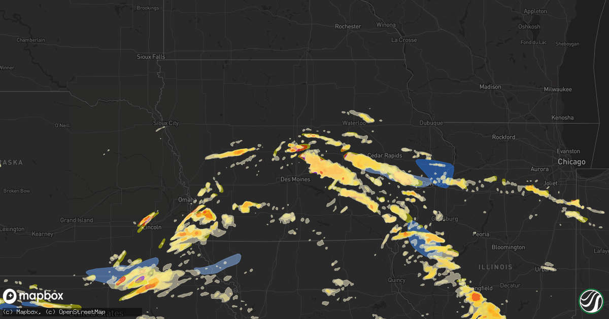
Hail Map in Iowa on May 7, 2023
Get this storm
May 7 map
$229
one time, instant access
Download today. No call, no setup
Keep the $229
Bought the map and want the full workflow? Apply the entire $229 to a subscription within 7 days. None of it is wasted.
Every map, not just this one
This buys you this map. Subscription and you get every map we run, in the markets you choose from a few cities to whole states to nationwide. Plus real-time alerts the moment a storm fires.
Contact data
Name, contact info, occupancy, even credit band for addresses in the footprint. You go from where it hit to who to call.
Become the source they trust
Unlimited branding weather history reports on demand. You already have the documented answer ready for the property owner, and you are the one who showed up with it.
Property data and RoofTrace estimates
Pull up any address you have got, its value and the exact code rules for that jurisdiction, straight from One Click Code. Then RoofTrace estimates the squares, pitch, and roof value, priced the way you price.
Storm reports in Iowa
Iowa
| Date | Description |
|---|---|
| 05/07/20236:50 PM CDT | Awos. |
| 05/07/20236:48 PM CDT | Large branches down. Relayed by ktvo. |
| 05/07/20236:38 PM CDT | Roof torn off a manufactured home due to the straight line winds. |
| 05/07/20236:35 PM CDT | Time estimated. |
| 05/07/20236:35 PM CDT | Wind from the north estimated to be 80 mph. Described as like a hurricane. The strong winds lasted for about 20 minutes. Power out about 630 pm before wind. A 6 inch di |
| 05/07/20236:35 PM CDT | 3 inch tree snapped at base. |
| 05/07/20236:32 PM CDT | Asos station kdvn davenport arpt. |
| 05/07/20236:32 PM CDT | Off duty nws employee estimated winds of 70 mph. He also reported nickel size hail and large tree branches down near 53rd street and us 61 in davenport. |
| 05/07/20236:31 PM CDT | Report from mping: quarter |
| 05/07/20236:31 PM CDT | Awos station kcwi clinton arpt. |
| 05/07/20236:28 PM CDT | Asos station kdvn davenport arpt. |
| 05/07/20236:28 PM CDT | Tree limbs down across town and powerlines down. |
| 05/07/20236:26 PM CDT | A local report indicates 1.00 inch wind near 1 SSW WASHINGTON |
| 05/07/20236:25 PM CDT | A local report indicates 1.00 inch wind near WASHINGTON |
| 05/07/20236:23 PM CDT | Report from mping: quarter |
| 05/07/20236:21 PM CDT | A local report indicates 1.75 inch wind near FRUITLAND |
| 05/07/20236:17 PM CDT | Corrects previous hail report from ollie. |
| 05/07/20236:17 PM CDT | A local report indicates 1.00 inch wind near OLLIE |
| 05/07/20236:15 PM CDT | A local report indicates 60 MPH wind near DEWITT |
| 05/07/20236:11 PM CDT | 12 inch diameter tree blown down. Time estimated. |
| 05/07/20236:10 PM CDT | Awos. |
| 05/07/20236:03 PM CDT | Wind gust estimated 50-60 mph. |
| 05/07/20236:02 PM CDT | A local report indicates 1.00 inch wind near 2 SSE HILLS |
| 05/07/20236:00 PM CDT | A local report indicates 1.00 inch wind near ATALISSA |
| 05/07/20235:59 PM CDT | 15-18 diameter limbs down. Minor siding and shingle damage. |
| 05/07/20235:59 PM CDT | Large tree fell on a shed. Time estimated from radar. |
| 05/07/20235:58 PM CDT | Time estimated from radar. |
| 05/07/20235:55 PM CDT | Report from mping: golf ball |
| 05/07/20235:52 PM CDT | A local report indicates 1.25 inch wind near 1 S ELWOOD |
| 05/07/20235:51 PM CDT | Semi trailer blown down along i-80. Time estimated using radar. |
| 05/07/20235:51 PM CDT | Semi trailer blown down along i-80. |
| 05/07/20235:50 PM CDT | A local report indicates 1.00 inch wind near KALONA |
| 05/07/20235:45 PM CDT | Report from mping: quarter |
| 05/07/20235:43 PM CDT | Delayed report. Image provided via social media. Time estimated from radar. |
| 05/07/20235:41 PM CDT | Delayed report. Time estimated from radar. |
| 05/07/20235:36 PM CDT | Time estimated from radar. |
| 05/07/20235:35 PM CDT | A local report indicates 70 MPH wind near WEST BRANCH |
| 05/07/20235:29 PM CDT | 55 knot wind gust. |
| 05/07/20235:25 PM CDT | A local report indicates 1.00 inch wind near 1 ESE NORTH LIBERTY |
| 05/07/20235:24 PM CDT | A local report indicates 1.00 inch wind near 1 ENE NORTH LIBERTY |
| 05/07/20235:24 PM CDT | Report of quarter sized hail with potentially a few larger hailstones present. |
| 05/07/20235:23 PM CDT | A local report indicates 1.00 inch wind near 4 ENE IOWA CITY |
| 05/07/20235:22 PM CDT | Report from mping: quarter |
| 05/07/20235:20 PM CDT | Corrects previous hail report from 2 nne north liberty. Report from mping: quarter |
| 05/07/20235:20 PM CDT | Report from mping: quarter |
| 05/07/20235:19 PM CDT | Asos station kiow iowa city arpt. |
| 05/07/20235:19 PM CDT | A local report indicates 60 MPH wind near 2 NNW NORTH LIBERTY |
| 05/07/20235:13 PM CDT | Tree down. |
| 05/07/20235:13 PM CDT | A local report indicates 1.00 inch wind near 2 W CORALVILLE |
| 05/07/20235:11 PM CDT | Several large tree branches down in town... With multiple smaller limbs. Time estimated from radar. |
| 05/07/20235:10 PM CDT | A local report indicates 70 MPH wind near 1 ENE TIFFIN |
| 05/07/20235:10 PM CDT | 70 to 80 mph wind gusts. Dust with reduced visibility. Also dime to nickel hail. |
| 05/07/20235:10 PM CDT | A local report indicates 1.75 inch wind near WEVER |
| 05/07/20235:10 PM CDT | Delayed report. Time estimated from radar. |
| 05/07/20235:09 PM CDT | Several significant trees down over 1 foot and a half in diameter. |
| 05/07/20235:09 PM CDT | Time estimated from radar. |
| 05/07/20235:08 PM CDT | Time estimated. Also dime to nickel hail. |
| 05/07/20235:05 PM CDT | Several trees down and topped in fw kent park. Time estimated. |
| 05/07/20235:04 PM CDT | A local report indicates 1.25 inch wind near 1 SE DENMARK |
| 05/07/20235:03 PM CDT | A local report indicates 1.00 inch wind near WEVER |
| 05/07/20235:00 PM CDT | Asos station kcid cedar rapids arpt. |
| 05/07/20235:00 PM CDT | Damage to hangar at greencastle airport... Time estimated from radar. |
| 05/07/20235:00 PM CDT | Several medium sized tree limbs down. |
| 05/07/20235:00 PM CDT | Reported 56 mph winds with nickel to quarter sized hail. |
| 05/07/20235:00 PM CDT | Delayed report. |
| 05/07/20234:58 PM CDT | Semi blown over carrying us mail on interstate 80 near mile marker 232. Time estimated from radar. |
| 05/07/20234:57 PM CDT | Via social media. |
| 05/07/20234:57 PM CDT | Gutters blown off. 10 inch diameter branch down. Dumpster blew down alley. |
| 05/07/20234:57 PM CDT | A local report indicates 1.00 inch wind near AMANA |
| 05/07/20234:56 PM CDT | Time estimated from radar. |
| 05/07/20234:56 PM CDT | Time estimated from radar. |
| 05/07/20234:53 PM CDT | Semi trailer blown over at mile marker 185 on interstate 80 between grinnell and malcolm exits. Via iowa dot camera. |
| 05/07/20234:50 PM CDT | Spotter reported strong winds and large hail with wide range of sizes. Potentially some wind damage. |
| 05/07/20234:47 PM CDT | A local report indicates 1.00 inch wind near 1 S DENMARK |
| 05/07/20234:47 PM CDT | A local report indicates 1.75 inch wind near 1 W WEST POINT |
| 05/07/20234:45 PM CDT | A local report indicates 1.50 inch wind near 1 NNW GRINNELL |
| 05/07/20234:45 PM CDT | 10x10 shed was blown into a fence and several houses nearby on hwy 6 had large trees down. |
| 05/07/20234:44 PM CDT | A local report indicates 1.00 inch wind near 1 SSE DENMARK |
| 05/07/20234:42 PM CDT | Via social media. |
| 05/07/20234:42 PM CDT | Trailers blown over at a dealership south of grinnell. Report via social media. |
| 05/07/20234:40 PM CDT | Accompanied by strong winds as well. Via social media. |
| 05/07/20234:35 PM CDT | Estimated higher than 60 mph wind gusts. |
| 05/07/20234:35 PM CDT | Quarter sized hail. |
| 05/07/20234:35 PM CDT | Mostly dimes. |
| 05/07/20234:34 PM CDT | Image submitted from social media with wide range of hail stones along i-80. Timing estimated from radar. |
| 05/07/20234:33 PM CDT | Via social media. |
| 05/07/20234:33 PM CDT | A local report indicates 65 MPH wind near 1 WSW MARENGO |
| 05/07/20234:32 PM CDT | Estimated 70 mph winds near g avenue and 212. |
| 05/07/20234:32 PM CDT | A local report indicates 1.50 inch wind near 4 N MARENGO |
| 05/07/20234:30 PM CDT | Reports submitted via social media of 1.75 to 2 inch hail south of kellogg... Time estimated from radar. |
| 05/07/20234:28 PM CDT | A local report indicates 2.75 inch wind near 2 SE KOSZTA |
| 05/07/20234:23 PM CDT | Golf ball hail. Relayed by emergency management. |
| 05/07/20234:23 PM CDT | Golf ball hail. Relayed by emergency mana |
| 05/07/20234:21 PM CDT | Via mping. |
| 05/07/20234:20 PM CDT | Golf ball-baseball sized hail. |
| 05/07/20234:20 PM CDT | Via social media. |
| 05/07/20234:19 PM CDT | One inch hail and 54 mph gust. |
| 05/07/20234:17 PM CDT | Image submitted via social media. |
| 05/07/20234:17 PM CDT | Image submitted via social media... Timing based on radar. |
| 05/07/20234:17 PM CDT | Delayed report. Image submitted via social media. Precise measurement of 2.13 inches. Time estimated from radar. |
| 05/07/20234:16 PM CDT | A local report indicates 1.50 inch wind near NEWTON |
| 05/07/20234:14 PM CDT | Image submitted via social media. Timing based on radar. |
| 05/07/20234:08 PM CDT | Delayed report. Time estimated from radar. |
| 05/07/20234:08 PM CDT | A local report indicates 1.50 inch wind near BELLE PLAINE |
| 05/07/20234:05 PM CDT | A local report indicates 1.00 inch wind near BELLE PLAINE |
| 05/07/20234:00 PM CDT | Timing based on radar. |
| 05/07/20234:00 PM CDT | Delayed report. Image submitted via social media. |
| 05/07/20234:00 PM CDT | Golf-ball sized hail and strong winds. |
| 05/07/20233:56 PM CDT | Image submitted via social media indicating ping pong sized hail outside of colfax. Location estimated based on radar. |
| 05/07/20233:55 PM CDT | A local report indicates 1.25 inch wind near 4 SE COLLINS |
| 05/07/20233:49 PM CDT | A local report indicates 1.50 inch wind near 6 ESE GARWIN |
| 05/07/20233:47 PM CDT | Time estimated from radar. |
| 05/07/20233:45 PM CDT | Report of power lines down heading eastbound on 310th street from collins. Timing estimated from radar. |
| 05/07/20233:42 PM CDT | A local report indicates 1.75 inch wind near COLLINS |
| 05/07/20233:42 PM CDT | Grain bin blown into field. Timing estimated by radar. |
| 05/07/20233:30 PM CDT | Submitted via social media. |
| 05/07/20233:10 PM CDT | (d |
| 05/07/20233:10 PM CDT | 1.0 to 2.0 inch hail. |
| 05/07/20233:10 PM CDT | A local report indicates 2.50 inch wind near 3 NNW AMES |
| 05/07/20233:10 PM CDT | Image submitted via twitter. |
| 05/07/20233:08 PM CDT | A local report indicates 1.50 inch wind near GILBERT |
| 05/07/20233:08 PM CDT | Image submitted via social media. |
| 05/07/20233:07 PM CDT | A local report indicates 1.50 inch wind near STORY CITY |
| 05/07/20233:07 PM CDT | A local report indicates 1.25 inch wind near 3 NW AMES |
| 05/07/20233:04 PM CDT | A local report indicates 1.00 inch wind near GILBERT |
| 05/07/20232:56 PM CDT | Story county law enforcement reports nickel to quarter sized hail falling. |
| 05/07/20232:07 PM CDT | Report from twitter. Time estimated from radar. |
| 05/07/20231:41 PM CDT | Via social media. |
| 05/07/20231:40 PM CDT | Quarter hail in carroll relayed via law enforcement. |
| 05/07/20231:37 PM CDT | Via broadcast media. |
| 05/07/20231:20 PM CDT | Dime-quarter sized heal. |
| 05/06/202311:05 PM CDT | Report from mping: quarter |
| 05/06/202310:48 PM CDT | Report from mping. Time estimated from radar. |
| 05/06/202310:41 PM CDT | 1 inch hail northwest of le roy. Location estimated from radar. |
| 05/06/202310:16 PM CDT | Estimated severe straight-line winds with minor flying debris near the i-35/highway 34 interchange. |
| 05/06/202310:13 PM CDT | A local report indicates 1.25 inch wind near MCCLELLAND |
| 05/06/202310:00 PM CDT | A local report indicates 1.00 inch wind near OGDEN |
| 05/06/20239:50 PM CDT | A local report indicates 1.25 inch wind near LITTLETON |
| 05/06/20239:49 PM CDT | A local report indicates 1.00 inch wind near 1 N WALNUT |
| 05/06/20239:33 PM CDT | A local report indicates 1.75 inch wind near 2 E HUBBARD |
| 05/06/20239:31 PM CDT | A local report indicates 1.00 inch wind near CLARINDA |
| 05/06/20239:30 PM CDT | Report via social media. Time estimated from radar. |
| 05/06/20239:21 PM CDT | A local report indicates 1.00 inch wind near 5 N CRESTON |
| 05/06/20239:03 PM CDT | Report from mping: quarter |
| 05/06/20238:45 PM CDT | A local report indicates 1.75 inch wind near 2 SSW IMOGENE |
| 05/06/20238:41 PM CDT | A local report indicates 1.00 inch wind near 4 SW STANTON |
| 05/06/20238:38 PM CDT | A local report indicates 1.00 inch wind near HAMBURG |
| 05/06/20238:27 PM CDT | Report from mping: golf ball |
| 05/06/20238:26 PM CDT | A local report indicates 1.75 inch wind near 3 WSW SIDNEY |
| 05/06/20238:08 PM CDT | Corrects time and location of previous tornado report from 2 s nebraska city. Brief weak looking tornado kicking up a bit of dust. Time is estimated based on radar data |
| 05/06/20238:00 PM CDT | Corrects time of previous hail report from 4 s bridgewater. Hail fell for about 20 minutes. Damage to siding. |
| 05/06/20237:56 PM CDT | A local report indicates 1.00 inch wind near BRIDGEWATER |
| 05/06/20237:54 PM CDT | A local report indicates 1.50 inch wind near 4 ESE GLENWOOD |
| 05/06/20237:54 PM CDT | A local report indicates 1.00 inch wind near MALVERN |
| 05/06/20237:53 PM CDT | A local report indicates 1.00 inch wind near 5 WSW MALVERN |
| 05/06/20237:50 PM CDT | Hail fell for about 20 minutes. Damage to siding. |
| 05/06/20237:50 PM CDT | Largest stones were tennis ball sized. Damage to siding on house. |
| 05/06/20237:42 PM CDT | A local report indicates 2.00 inch wind near 2 SW MOUNT PLEASANT |
| 05/06/20237:40 PM CDT | Hail varying in sizes from 1.75 inches to 2.25 inches. |
| 05/06/20237:35 PM CDT | Delayed report. |
| 05/06/20237:34 PM CDT | A local report indicates 1.00 inch wind near GLENWOOD |
| 05/06/20237:34 PM CDT | Hail measured using pennies nickels and quarters. Quarter size hail max. |
| 05/06/20237:34 PM CDT | A local report indicates 1.00 inch wind near 1 SE WEST BURLINGTON |
| 05/06/20237:31 PM CDT | Asos station kbrl burlington arpt. |
| 05/06/20237:30 PM CDT | 60-65 mph gust and sheet rain. |
| 05/06/20237:30 PM CDT | A local report indicates 1.00 inch wind near 5 WSW MALVERN |
| 05/06/20237:30 PM CDT | Parking signs bent over. Time estimated. |
| 05/06/20237:21 PM CDT | Nickle to quarter with heavy rain. |
All States Impacted by Hail Map on May 7, 2023
Cities Impacted by Hail Map on May 7, 2023
- Perrysville, IN
- Covington, IN
- Williamsport, IN
- Attica, IN
- Shelbyville, KY
- Carbondale, IL
- Tamaroa, IL
- Sesser, IL
- Scheller, IL
- Ozark, IL
- Creal Springs, IL
- New Burnside, IL
- Stonefort, IL
- Gillett, TX
- Corydon, IN
- Leavenworth, IN
- Falls City, TX
- Mulkeytown, IL
- Benton, IL
- Du Quoin, IL
- Floresville, TX
- Cave City, KY
- Evansville, IN
- Elberfeld, IN
- Haubstadt, IN
- Dakota City, NE
- Cotulla, TX
- Henryville, IN
- Sellersburg, IN
- Borden, IN
- Memphis, IN
- Herod, IL
- Eddyville, IL
- George West, TX
- Glasgow, KY
- Crystal City, TX
- La Pryor, TX
- Batesville, TX
- Hubbard, NE
- Utica, KY
- Hartford, KY
- Cynthiana, KY
- Lynnville, IN
- Meadow Grove, NE
- Springerton, IL
- Mill Shoals, IL
- Burnt Prairie, IL
- Carmi, IL
- Enfield, IL
- Pomona, IL
- Murphysboro, IL
- Raleigh, IL
- Harrisburg, IL
- Galatia, IL
- Eckerty, IN
- Lewisport, KY
- Beecher City, IL
- Dale, IN
- Winnebago, NE
- Jasper, IN
- Philpot, KY
- New Salisbury, IN
- Georgetown, IN
- Brooks, KY
- Louisville, KY
- Fairdale, KY
- Oakland, IL
- Shepherdsville, KY
- Elizabeth, IN
- West Point, KY
- Golden Gate, IL
- Ellery, IL
- Nortonville, KY
- White Plains, KY
- Owensville, IN
- Princeton, IN
- Yorktown, TX
- Lebanon Junction, KY
- Bardstown, KY
- Boston, KY
- Coxs Creek, KY
- Clermont, KY
- Mount Vernon, IN
- Earlington, KY
- Mortons Gap, KY
- Dawson Springs, KY
- Madisonville, KY
- Guthrie Center, IA
- Sharpsburg, KY
- Owingsville, KY
- Makanda, IL
- New Albany, IN
- Dixon, KY
- Buckner, IL
- Logan, IL
- Christopher, IL
- West Frankfort, IL
- Thompsonville, IL
- Waverly, OH
- Beaver, OH
- Gentryville, IN
- Stendal, IN
- Boonville, IN
- Holland, IN
- Tennyson, IN
- Nordheim, TX
- Cuero, TX
- New Middletown, IN
- Lanesville, IN
- Laconia, IN
- Brandenburg, KY
- Campbellsburg, IN
- Salem, IN
- Newburgh, IN
- Sigel, IL
- Neoga, IL
- Leitchfield, KY
- Brownsville, KY
- Roundhill, KY
- Caneyville, KY
- Bee Spring, KY
- English, IN
- Berry, KY
- Karnes City, TX
- Runge, TX
- Milltown, IN
- Depauw, IN
- Whitesville, KY
- Taswell, IN
- Urbana, IL
- Saint Joseph, IL
- Champaign, IL
- Rockport, IN
- Chrisney, IN
- Grandview, IN
- Morgantown, KY
- Sweeden, KY
- Graham, KY
- Bremen, KY
- Springfield, KY
- Broughton, IL
- Norris City, IL
- Mauckport, IN
- Greenville, KY
- Sacramento, KY
- Goreville, IL
- Winslow, IN
- Hanson, KY
- Providence, KY
- Princeton, KY
- Saint Charles, KY
- Nebo, KY
- Manitou, KY
- Ogden, IL
- Horse Branch, KY
- Slaughters, KY
- McLeansboro, IL
- Dale, IL
- Macedonia, IL
- Orient, IL
- Kenedy, TX
- Beeville, TX
- Dahlgren, IL
- Paoli, IN
- Pekin, IN
- Hardinsburg, IN
- Fredericksburg, IN
- Thomasboro, IL
- Marion, IL
- Mount Sterling, KY
- Carlisle, KY
- Paris, KY
- Drakesboro, KY
- Poth, TX
- Simpson, IL
- Elizabethtown, IL
- Panora, IA
- Sebree, KY
- Wadesville, IN
- New Harmony, IN
- Finchville, KY
- Richland, IN
- Omaha, IL
- Ridgway, IL
- Campbellton, TX
- Dow City, IA
- Arion, IA
- Denison, IA
- Simpsonville, KY
- Chandler, IN
- Stewardson, IL
- Three Rivers, TX
- Tuscola, IL
- Manning, IA
- Westside, IA
- Arcadia, IA
- Carroll, IA
- Halbur, IA
- Glidden, IA
- Addieville, IL
- Okawville, IL
- Nashville, IL
- Hoyleton, IL
- Golconda, IL
- Smithland, KY
- Hampton, KY
- Manilla, IA
- Vail, IA
- Rosiclare, IL
- Sharon, TN
- Dresden, TN
- Greenfield, TN
- Gleason, TN
- Waverly, IL
- Loami, IL
- Chatham, IL
- Energy, IL
- Carterville, IL
- Johnston City, IL
- Herrin, IL
- Pittsburg, IL
- Bonnie, IL
- Mount Vernon, IL
- Waltonville, IL
- Opdyke, IL
- Dunning, NE
- Henry, TN
- McKenzie, TN
- Paris, TN
- Belle Rive, IL
- Eldorado, IL
- Auburn, IL
- Springfield, IL
- Purdum, NE
- Glenarm, IL
- Divernon, IL
- Pawnee, IL
- Boone, IA
- Ames, IA
- Gilbert, IA
- Nevada, IA
- Story City, IA
- Virden, IL
- Roland, IA
- Zearing, IA
- McCallsburg, IA
- Cambridge, IA
- Maxwell, IA
- Collins, IA
- Colo, IA
- Mingo, IA
- Baxter, IA
- Rhodes, IA
- State Center, IA
- Melbourne, IA
- Toledo, IA
- Clutier, IA
- Tama, IA
- Chelsea, IA
- Vining, IA
- Elberon, IA
- Morrisonville, IL
- Roscoe, TX
- Clarksville, TN
- Oak Grove, KY
- Colfax, IA
- Trenton, KY
- Newton, IA
- Sweetwater, TX
- Roby, TX
- Oliver Springs, TN
- Briceville, TN
- Powell, TN
- Clinton, TN
- Heiskell, TN
- Hopkinsville, KY
- Herndon, KY
- Cadiz, KY
- Rowena, TX
- Miles, TX
- Ira, IA
- Ballinger, TX
- Haverhill, IA
- Laurel, IA
- Idalia, CO
- Burlington, CO
- Kanorado, KS
- Goodland, KS
- Mereta, TX
- Charleston, MO
- New Berlin, IL
- Industry, IL
- Adair, IL
- Belle Plaine, IA
- Vermont, IL
- Hartwick, IA
- Victor, IA
- Marengo, IA
- Knoxville, TN
- Van Horne, IA
- Luzerne, IA
- Ladora, IA
- Blairstown, IA
- Keystone, IA
- Haigler, NE
- Rotan, TX
- Wray, CO
- Hamlin, TX
- Grinnell, IA
- Gilman, IA
- Kellogg, IA
- Palmer, IL
- Nokomis, IL
- Lynnville, IA
- Rushville, IL
- Bird City, KS
- Wickliffe, KY
- Barlow, KY
- Snyder, TX
- Searsboro, IA
- Montezuma, IA
- Malcom, IA
- Seymour, TX
- Guthrie, KY
- Allensville, KY
- Elkton, KY
- Olmstead, KY
- Russellville, KY
- La Center, KY
- Rosamond, IL
- Winters, TX
- Edson, KS
- McDonald, KS
- Aspermont, TX
- Middle Amana, IA
- Amana, IA
- Watkins, IA
- Norway, IA
- Fort Madison, IA
- West Point, IA
- Alzada, MT
- Wever, IA
- Hulett, WY
- Astoria, IL
- Ipava, IL
- Adairville, KY
- Brooklyn, IA
- Kevil, KY
- Barnes City, IA
- Williamsburg, IA
- Conroy, IA
- South Amana, IA
- Tiffin, IA
- Oxford, IA
- Homestead, IA
- Iowa City, IA
- Coralville, IA
- Swisher, IA
- North Liberty, IA
- Sylvester, TX
- Ohlman, IL
- Pana, IL
- Oconee, IL
- Fairfax, IA
- Auburn, KY
- Franklin, KY
- Alexander, IL
- Guernsey, IA
- Gibson, IA
- Deep River, IA
- Pleasant Plains, IL
- Ashland, IL
- Mansfield, TN
- Pella, IA
- Springville, TN
- Sully, IA
- Levant, KS
- Colby, KS
- Brewster, KS
- New Sharon, IA
- Atwood, KS
- Browning, IL
- Havana, IL
- Kilbourne, IL
- Bath, IL
- Chandlerville, IL
- Benjamin, TX
- Cumberland Furnace, TN
- Vanleer, TN
- Ovalo, TX
- Solon, IA
- Boaz, KY
- Hickory, KY
- Sedalia, KY
- Tallula, IL
- Tuscola, TX
- Charlotte, TN
- Wellman, IA
- North English, IA
- Parnell, IA
- Keswick, IA
- Webster, IA
- Buffalo Gap, TX
- Oskaloosa, IA
- Rose Hill, IA
- Burlington, IA
- West Paducah, KY
- Lone Tree, IA
- Wingate, TX
- West Branch, IA
- Belleville, IL
- O'Fallon, IL
- Merkel, TX
- Abilene, TX
- Tye, TX
- Waverly, TN
- McEwen, TN
- Erin, TN
- Rapid City, SD
- Lebanon, IL
- What Cheer, IA
- Delta, IA
- Gracey, KY
- New Athens, IL
- West Liberty, IA
- Atalissa, IA
- Tipton, IA
- White Bluff, TN
- Kalona, IA
- Ellsworth Afb, SD
- Box Elder, SD
- Selden, KS
- Dickson, TN
- McCaulley, TX
- Anson, TX
- Kingston Springs, TN
- Aladdin, WY
- Sigourney, IA
- Riverside, IA
- Harper, IA
- Hills, IA
- Keota, IA
- South English, IA
- Dresden, KS
- Hawley, TX
- Trent, TX
- Hayesville, IA
- Carman, IL
- Stronghurst, IL
- Lomax, IL
- Almo, KY
- Hardin, KY
- Benton, KY
- Media, IL
- Raritan, IL
- Ollie, IA
- Kirksey, KY
- Murray, KY
- Roseville, IL
- Smithshire, IL
- Villa Ridge, IL
- Dexter, KY
- Paint Rock, TX
- Nichols, IA
- Muscatine, IA
- Moscow, IA
- Wilton, IA
- Jennings, KS
- Oberlin, KS
- Freeburg, IL
- Durant, IA
- Blue Grass, IA
- Stockton, IA
- New Underwood, SD
- Port Byron, IL
- Hillsdale, IL
- Hillsboro, IL
- Butler, IL
- Clayton, KS
- Lenora, KS
- Morland, KS
- Eola, TX
- San Angelo, TX
- Irving, IL
- Coon Rapids, IA
- Jewell, IA
- Randall, IA
- Jefferson, IA
- Churdan, IA
- Scranton, IA
- Red Bud, IL
- Marine, IL
- Edwardsville, IL
- Metropolis, IL
- Pocahontas, IL
- Radcliffe, IA
- Sullivan, IN
- Taylorville, IL
- Big Rock, TN
- La Fayette, KY
- Stanhope, IA
- Vienna, IL
- Caryville, TN
- Highland, IL
- Trenton, IL
- Aviston, IL
- Breese, IL
- Russellville, TN
- Salem, KY
- Marion, KY
- Breda, IA
- Tallulah, LA
- Richview, IL
- Ashley, IL
- Farmersville, IL
- Bardwell, KY
- Louisville, IL
- Calvert City, KY
- Symsonia, KY
- Paducah, KY
- Carlyle, IL
- Maryville, IL
- Granite City, IL
- Collinsville, IL
- Audubon, IA
- Dukedom, TN
- Fulton, KY
- Odin, IL
- Salem, IL
- Macomb, IL
- Marshalltown, IA
- Lewisburg, KY
- Centralia, IL
- Whitesburg, TN
- Morristown, TN
- Crowell, TX
- Kinmundy, IL
- Fairview Heights, IL
- Scott Air Force Base, IL
- South Fulton, TN
- Martin, TN
- Eddyville, KY
- Lake City, IA
- Hammond, MT
- Lenzburg, IL
- Jefferson City, TN
- De Soto, IL
- Alto Pass, IL
- Cambria, IL
- Wolf Lake, IL
- Pembroke, KY
- Melber, KY
- Cunningham, KY
- Talbott, TN
- White Pine, TN
- Dandridge, TN
- New Market, TN
- Newport, TN
- Fredonia, KY
- Du Bois, IL
- Ina, IL
- Kuttawa, KY
- Scottsville, KY
- Bean Station, TN
- Oakdale, IL
- Mohawk, TN
- Rives, TN
- Pulaski, IL
- Grand Chain, IL
- Karnak, IL
- Mayfield, KY
- Mounds, IL
- Ullin, IL
- Olmsted, IL
- Beech Creek, KY
- Belton, KY
- Dunmor, KY
- New Baden, IL
- Alva, WY
- Palmyra, TN
- Cumberland City, TN
- Fort Campbell, KY
- Wartburg, TN
- Elkville, IL
- Xenia, IL
- Farina, IL
- Crofton, KY
- Vergennes, IL
- Ralston, IA
- Gilbertsville, KY
- Crossville, IL
- Walshville, IL
- Litchfield, IL
- Thorn Hill, TN
- Saint Francis, KS
- Stewart, TN
- Tennessee Ridge, TN
- Big Sandy, TN
- Hurst, IL
- Royalton, IL
- Saint Jacob, IL
- Seneca, NE
- Thedford, NE
- Halsey, NE
- Hermleigh, TX
- Huntsville, TN
- Rocky Top, TN
- Jonesboro, IL
- Orlinda, TN
- Springfield, TN
- Buncombe, IL
- Dongola, IL
- Woodlawn, IL
- Carrier Mills, IL
- Equality, IL
- Zeigler, IL
- Ava, IL
- Dowell, IL
- Belknap, IL
- Cobden, IL
- Cypress, IL
- Anna, IL
- Jamestown, TN
- Deer Lodge, TN
- Millstadt, IL
- Grand Rivers, KY
- Miller City, IL
- Thebes, IL
- Taylor Springs, IL
- Robards, KY
- Tamms, IL
- Pinckneyville, IL
- New Haven, IL
- Pine Bluff, AR
- Midkiff, TX
- Merom, IN
- Mascoutah, IL
- Pegram, TN
- Nashville, TN
- Franklin, TN
- Brentwood, TN
- Coffeen, IL
- Big Lake, TX
- Garden City, TX
- Raymond, IL
- Nilwood, IL
- Waggoner, IL
- Carlinville, IL
- Washington, IA
- Wayland, IA
- Richland, IA
- Fairfield, IA
- Brighton, IA
- Colona, IL
- Geneseo, IL
- Antioch, TN
- Ozona, TX
- Iraan, TX
- Prophetstown, IL
- Hooppole, IL
- Walcott, IA
- Davenport, IA
- Hill City, KS
- Penokee, KS
- Wheatland, IA
- Lost Nation, IA
- Lowden, IA
- Grand Mound, IA
- Bennett, IA
- Donahue, IA
- Dixon, IA
- Calamus, IA
- New Liberty, IA
- Long Grove, IA
- Goose Lake, IA
- De Witt, IA
- Delmar, IA
- Norcatur, KS
- Eldridge, IA
- Moline, IL
- McCausland, IA
- Rock Island, IL
- Princeton, IA
- Camanche, IA
- Bettendorf, IA
- Le Claire, IA
- Clinton, IA
- Coal Valley, IL
- Hampton, IL
- Carbon Cliff, IL
- Low Moor, IA
- Pleasant Valley, IA
- East Moline, IL
- Silvis, IL
- Cordova, IL
- Rapids City, IL
- Harvel, IL
- Packwood, IA
- Winfield, IA
- Mount Pleasant, IA
- Mount Union, IA
- Yarmouth, IA
- Good Hope, IL
- Avon, IL
- Prairie City, IL
- Bushnell, IL
- Colchester, IL
- Owanka, SD
- Annawan, IL
- Bogue, KS
- Albany, IL
- Erie, IL
- Fulton, IL
- Kensington, KS
- Smith Center, KS
- Belleville, KS
- Scandia, KS
- Mankato, KS
- Esbon, KS
- Logan, KS
- Gaylord, KS
- Kirwin, KS
- Courtland, KS
- Phillipsburg, KS
- Athol, KS
- Lebanon, KS
- Glade, KS
- Prairie View, KS
- Cuba, KS
- Grant Park, IL
- Momence, IL
- Morning Sun, IA
- Narka, KS
- Mahaska, KS
- Mediapolis, IA
- Haddam, KS
- Schneider, IN
- Lowell, IN
- Stockton, KS
- Hebron, NE
- Newark, IL
- Gilead, NE
- Alexandria, NE
- Belvidere, NE
- Daykin, NE
- Tobias, NE
- Unadilla, NE
- Burr, NE
- Syracuse, NE
- Mendota, IL
- Fairbury, NE
- Sublette, IL
- La Moille, IL
- Ohio, IL
- Amboy, IL
- Sciota, IL
- Bardolph, IL
- Pacific Junction, IA
- Plattsmouth, NE
- Glenwood, IA
- Mount Sterling, IL
- Malvern, IA
- Morrowville, KS
- New London, IA
- Sperry, IA
- Washington, KS
- Table Grove, IL
- Marietta, IL
- Otoe, NE
- Dunbar, NE
- Woodston, KS
- Morris, IL
- Seneca, IL
- Wasta, SD
- Wall, SD
- Endicott, NE
- Hollenberg, KS
- Clyde, KS
- Clifton, KS
- Palmer, KS
- Avoca, NE
- Nehawka, NE
- Western, NE
- Smithfield, IL
- Cuba, IL
- Jansen, NE
- Knox City, TX
- Munday, TX
- Biggsville, IL
- Gladstone, IL
- Lewistown, IL
- Alton, KS
- Tabor, IA
- Hastings, IA
- Linn, KS
- Diller, NE
- Hanover, KS
- Adams, NE
- Plymouth, NE
- Douglas, NE
- Palmyra, NE
- Firth, NE
- Nebraska City, NE
- Weeping Water, NE
- Murray, NE
- Osborne, KS
- Portis, KS
- Corning, IA
- Bridgewater, IA
- Prescott, IA
- Fontanelle, IA
- Massena, IA
- Orient, IA
- Belle Fourche, SD
- Clinton, KY
- Villisca, IA
- Nisland, SD
- Newell, SD
- Cumberland, IA
- Emerson, IA
- Sterling, NE
- Cook, NE
- Talmage, NE
- Lorton, NE
- Downs, KS
- Greenleaf, KS
- Percival, IA
- Thurman, IA
- Union, NE
- Odell, NE
- Bremen, KS
- Marysville, KS
- Cawker City, KS
- Steele City, NE
- Blue Springs, NE
- Wymore, NE
- Dallas City, IL
- Blandinsville, IL
- Carthage, IL
- La Harpe, IL
- West Burlington, IA
- Barnes, KS
- Tennessee, IL
- Glen Elder, KS
- Milford, NE
- Pleasant Dale, NE
- Lincoln, NE
- Denton, NE
- Quinn, SD
- Malcolm, NE
- Philip, SD
- Raymond, NE
- Davey, NE
- Ceresco, NE
- Sturgis, SD
- Whitewood, SD
- Vale, SD
- Seward, NE
- Garland, NE
- Oketo, KS
- Creston, IA
- Beloit, KS
- Waterville, KS
- Stanton, IA
- Red Oak, IA
- Wilmington, IL
- Channahon, IL
- Coal City, IL
- Elwood, IL
- Silver City, IA
- Mineola, IA
- Plymouth, IL
- Sidney, IA
- Hamburg, IA
- Liberty, NE
- Barneston, NE
- Beattie, KS
- Tecumseh, NE
- Brock, NE
- Johnson, NE
- Peru, NE
- Julian, NE
- Waverly, NE
- Home, KS
- Summerfield, KS
- Burchard, NE
- Riverton, IA
- Rock Port, MO
- Farragut, IA
- Superior, NE
- Webber, KS
- Hardy, NE
- Clyde, TX
- Hubbard, IA
- New Providence, IA
- Union, IA
- Eldora, IA
- Pembroke Township, IL
- Saint Anne, IL
- Beaverville, IL
- Morocco, IN
- Palo Pinto, TX
- Brook, IN
- Graford, TX
- Mineral Wells, TX
- Guntown, MS
- Baldwyn, MS
- Pawnee City, NE
- Oakland, IA
- Booneville, MS
- Marietta, MS
- Walnut, IA
- Avoca, IA
- Hancock, IA
- Mount Ayr, IN
- Whitten, IA
- Conrad, IA
- Fairbank, IA
- Dunkerton, IA
- Jesup, IA
- Independence, IA
- Hazleton, IA
- Hudson, IA
- La Porte City, IA
- Waterloo, IA
- Buckingham, IA
- Dyess Afb, TX
- Council Bluffs, IA
- McClelland, IA
- Underwood, IA
- Beaman, IA
- Baird, TX
- Liscomb, IA
- Ogden, IA
- Republic, KS
- Ruskin, NE
- Nelson, NE
- Byron, NE
- Hubbell, NE
- Deshler, NE
- Munden, KS
- Chester, NE
- Reynolds, NE
- Dawson, NE
- Salem, NE
- Verdon, NE
- Falls City, NE
- Neola, IA
- Minden, IA
- Craig, MO
- Rulo, NE
- Gladbrook, IA
- Shelby, IA
- Trezevant, TN
- Huntingdon, TN
- Riley, KS
- Manhattan, KS
- Beatrice, NE
- Saint George, KS
- Osceola, IA
- Mound City, MO
- Maitland, MO
- Skidmore, MO
- Weldon, IA
- Woodburn, IA
- Filley, NE
- Graham, MO
- Barnard, MO
- Maryville, MO
- Conception Junction, MO
- Virginia, NE
- Wamego, KS
- Kokomo, IN
- Bunker Hill, IN
- Sheffield, IL
- Manlius, IL
- Piedmont, SD
- Middletown, IA
- Danville, IA
- La Salle, IL
- Peru, IL
- Alma, IL
- Ethel, MS
- Van Orin, IL
- Walnut, IL
- Caseyville, IL
- White Hall, AR
- Saint Onge, SD
- Spearfish, SD
- Bruning, NE
- Humboldt, NE
- Ramsey, IL
- Fillmore, IL
- Mulberry Grove, IL
- West Point, IL
- Bowen, IL
- Hillsboro, TN
- Morrison, TN
- Lake Village, IN
- Dover, TN
- Indian Mound, TN
- Beardstown, IL
- Virginia, IL
- Arenzville, IL
- Meredosia, IL
- Castalian Springs, TN
- Gallatin, TN
- Alexis, IL
- Niota, IL
- Saint Anthony, IA
- Clemons, IA
- Kirkwood, IL
- Carlisle, AR
- Norton, KS
- Lexington, MS
- Benton, MS
- Yazoo City, MS
- Blue Rapids, KS
- Kankakee, IL
- Aroma Park, IL
- Donnellson, IA
- Girard, IL
- Palmyra, IL
- Vicksburg, MS
- Atkinson, IL
- Weinert, TX
- Goree, TX
- Mertzon, TX
- Burnettsville, IN
- Royal Center, IN
- Frankfort, KS
- Auburn, NE
- Farmington, KY
- Spencer, TN
- Timewell, IL
- Bentonia, MS
- Robinson, IL
- Wakefield, KS
- Milford, KS
- Clay Center, KS
- Leonardville, KS
- Sheridan, IL
- Ottawa, IL
- Aledo, IL
- Seaton, IL
- Belzoni, MS
- Altheimer, AR
- Essex, IA
- Shenandoah, IA
- Imogene, IA
- Carson, IA
- Treynor, IA
- Jacksonville, IL
- Concord, IL
- Iuka, MS
- Hedrick, IA
- Manteno, IL
- Corning, KS
- Centralia, KS
- Traer, IA
- Owaneco, IL
- Bingham, IL
- Palmersville, TN
- Utica, MS
- Crystal Springs, MS
- Hazlehurst, MS
- Sherrill, AR
- Illinois City, IL
- New Boston, IL
- Yorkville, IL
- Junction City, KS
- Fort Riley, KS
- Saltillo, MS
- Coin, IA
- Henderson, IA
- Yorktown, IA
- Clarinda, IA
- Randolph, IA
- Elvaston, IL
- Warsaw, IL
- Basco, IL
- Modesto, IL
- Long Island, KS
- Fruitland, IA
- Letts, IA
- Joy, IL
- Manchester, TN
- Beechgrove, TN
- Bradyville, TN
- Tracy City, TN
- Whitwell, TN
- Gerlaw, IL
- Sunset, SC
- Fayetteville, TN
- Woodbury, TN
- Carleton, NE
- Cedar Rapids, IA
- Hermanville, MS
- Wabash, IN
- Peru, IN
- Denver, IN
- O'Brien, TX
- Columbus Junction, IA
- Wapello, IA
- Guide Rock, NE
- Seneca, KS
- Bern, KS
- Bourbonnais, IL
- Rock Island, TN
- Fair Oaks, IN
- Gillespie, IL
- Bunker Hill, IL
- Wabbaseka, AR
- Humphrey, AR
- Camden, IL
- Table Rock, NE
- Readyville, TN
- Sorento, IL
- Doyle, TN
- Pikeville, TN
- Quebeck, TN
- Baileyville, KS
- Axtell, KS
- Du Bois, NE
- Steinauer, NE
- Lockridge, IA
- Bartelso, IL
- Vaughan, MS
- Pickens, MS
- Christiana, TN
- Murfreesboro, TN
- Burns, TN
- Cunningham, TN
- Fairview, TN
- Nolensville, TN
- Morrill, KS
- Sabetha, KS
- Mount Olive, IL
- Rochester, IL
- Witt, IL
- New Douglas, IL
- Thayer, IL
- Franklin, IL
- Benld, IL
- Mcminnville, TN
- Rochester, TX
- Rule, TX
- Agra, KS
- Nemaha, NE
- Altamont, TN
- Beersheba Springs, TN
- Brookport, IL
- New Bedford, IL
- Tampico, IL
- Coalmont, TN
- Grandview, IA
- East Prairie, MO
- Summerfield, IL
- Smithville, TN
- Old Glory, TX
- Oxford Junction, IA
- Clarence, IA
- Griswold, IA
- Galesburg, IL
- Cameron, IL
- Monmouth, IL
- Rensselaer, IN
- Crawfordsville, IA
- Olds, IA
- Logansport, IN
- Jamaica, IA
- Yale, IA
- Rippey, IA
- Bagley, IA
- Vermillion, KS
- Kewanna, IN
- Wedron, IL
- Serena, IL
- Marseilles, IL
- Almena, KS
- Frankewing, TN
- Cornersville, TN
- Petersburg, TN
- Pulaski, TN
- Hartsville, TN
- Dwight, IL
- Emington, IL
- Odell, IL
- Earlville, IL
- Walling, TN
- Papineau, IL
- Martinton, IL
- Princeton, IL
- Medaryville, IN
- Francesville, IN
- Wheatfield, IN
- Caddo, TX
- Breckenridge, TX
- Chaffee, MO
- Scott City, MO
- Dellrose, TN
- Woodward, IA
- Granger, IA
- Chillicothe, TX
- Glen Carbon, IL
- Lonoke, AR
- England, AR
- Idaville, IN
- Star City, IN
- Joliet, IL
- Taylor Ridge, IL
- Flora, MS
- Palestine, IL
- Parsons, TN
- Arlington, KY
- Minooka, IL
- Demotte, IN
- Troy, IL
- Fancy Farm, KY
- Burna, KY
- Utica, IL
- Linden, TN
- Michie, TN
- Peotone, IL
- Ashland City, TN
- Madrid, IA
- Centerville, IA
- Seymour, IA
- Vinton, IA
- Rowley, IA
- Ellsworth, IA
- Afton, IA
- Thayer, IA
- Ottumwa, IA
- Eddyville, IA
- Chillicothe, IA
- Kirkville, IA
- Huntsville, IL
- Slater, IA
- Alden, IA
- Argyle, IA
- Farmington, IA
- Kahoka, MO
- Wayland, MO
- Lawrenceburg, TN
- Collinwood, TN
- Waynesboro, TN
- Lutts, TN
- Cypress Inn, TN
- Loraine, IL
- Anamosa, IA
- Wyoming, IA
- Center Junction, IA
- Olin, IA
- Martelle, IA
- Everest, KS
- Lancaster, KS
- Denton, KS
- Wathena, KS
- Troy, KS
- Janesville, IA
- Waverly, IA
- North Henderson, IL
- Carrizo Springs, TX
- Wilsonville, IL
- Wolcott, IN
- Polk City, IA
- Harlan, IA
- Vassar, KS
- Lyndon, KS
- Quenemo, KS
- Perry, IA
- King City, MO
- Denver, IA
- Readlyn, IA
- Cedar Falls, IA
- Burnsville, MS
- Nauvoo, IL
- Grundy Center, IA
- Brownville, NE
- Promise City, IA
- Corydon, IA
- Wilsey, KS
- Osage City, KS
- Burlingame, KS
- Green Castle, MO
- Novinger, MO
- Garwin, IA
- Dysart, IA
- Chapman, KS
- Alta Vista, KS
- Abilene, KS
- Dwight, KS
- Enterprise, KS
- Alma, KS
- Weston, MO
- Lineville, IA
- Garden Grove, IA
- Reinbeck, IA
- Lorimor, IA
- Macksburg, IA
- Kelley, IA
- Garrison, IA
- Mount Auburn, IA
- Oelwein, IA
- Baldwin, IA
- Maquoketa, IA
- Murray, IA
- Panama, IL
- Donnellson, IL
- Faucett, MO
- Saint Joseph, MO
- De Kalb, MO
- Cromwell, IA
- Germantown, IL
- Humeston, IA
- Chariton, IA
- Derby, IA
- Dearborn, MO
- Wyaconda, MO
- Manhattan, IL
- Unionville, MO
- Highland, KS
- White Cloud, KS
- Robinson, KS
- Council Grove, KS
- Shell Rock, IA
- Manley, NE
- Louisville, NE
- Murdock, NE
- Topeka, KS
- Paxico, KS
- Olsburg, KS
- McFarland, KS
- Belvue, KS
- Maple Hill, KS
- Ellston, IA
- Shannon City, IA
- Tingley, IA
- Fairview, KS
- Goff, KS
- Wetmore, KS
- Strawn, TX
- Comstock, TX
- Sparland, IL
- Oregon, MO
- Fillmore, MO
- Hiawatha, KS
- Bendena, KS
- Atchison, KS
- Abingdon, IL
- Rushville, MO
- Peoria, IL
- Hanna City, IL
- Gardner, IL
- Triumph, IL
- Linton, IN
- Dugger, IN
- Greenville, IL
- Arlington, IL
- Cherry, IL
- Chapin, IL
- May, TX
- New Virginia, IA
- Horton, KS
- Cincinnati, IA
- Ashkum, IL
- Bussey, IA
- Brookfield, MO
- Van Wert, IA
- Grand River, IA
- Augusta, IL
- Allen, KS
- Truro, IA
- Rea, MO
- New Boston, MO
- Ethel, MO
- Elk Creek, NE
- Remington, IN
- Smithville, MO
- Edgerton, MO
- Trimble, MO
- Winthrop, IA
- Aurora, IA
- Shipman, IL
- Paducah, TX
- Watson, MO
- Kirkman, IA
- Camden Point, MO
- Platte City, MO
- Wyanet, IL
- Leon, IA
- Eureka, IL
- Edinburg, IL
- Nodaway, IA
- Lovilia, IA
- Hamilton, IA
- Powhattan, KS
- White City, KS
- Oneida, KS
- Iowa Falls, IA
- Frederick, IL
- Hettick, IL
- Holladay, TN
- Sugar Tree, TN
- Lueders, TX
- Kirksville, MO
- Cottage Grove, TN
- Albia, IA
- Albers, IL
- Norton, TX
- Counce, TN
- Bowling Green, KY
- Rockfield, KY
- Mendon, MO
- Keytesville, MO
- Saint Robert, MO
- Dixon, MO
- Newburg, MO
- Nebo, IL
- Elmer, MO
- Saint Paul, IA
- Jacksonville, MO
- Macon, MO
- Excello, MO
- Huntsville, MO
- Callao, MO
- Atlanta, MO
- Bevier, MO
- Crocker, MO
- Iron City, TN
- Sturgeon, MO
- Moweaqua, IL
- Clayton, IL
- Baylis, IL
- Scranton, KS
- Powderly, KY
- Marceline, MO
- Bucklin, MO
- New Cambria, MO
- Excelsior Springs, MO
- Orrick, MO
- Pomona, KS
- Ottawa, KS
- Cerulean, KY
- Anabel, MO
- California, MO
- Centertown, MO
- Salisbury, MO
- Kansas City, MO
- Kearney, MO
- Liberty, MO
- Rush Hill, MO
- Mexico, MO
- Santa Fe, MO
- Laddonia, MO
- Farber, MO
- Vandalia, MO
- Jayton, TX
- East Saint Louis, IL
- Nevada, MO
- Clifton Hill, MO
- Saint Augustine, IL
- Ainsworth, IA
- Clarksville, MO
- Salem, IA
- Staunton, IL
- Louisburg, MO
- Hamilton, IL
- Assumption, IL
- Camdenton, MO
- Berwick, IL
- Kewanee, IL
- Central City, KY
- Linn Creek, MO
- Clarence, MO
- Petersburg, IL
- Rising Star, TX
- Monroe, IA


