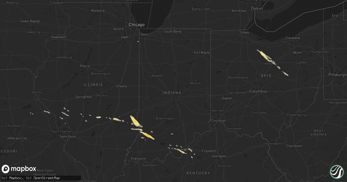
Hail Map in Indiana on May 7, 2016
Get this storm
May 7 map
$229
one time, instant access
Download today. No call, no setup
Keep the $229
Bought the map and want the full workflow? Apply the entire $229 to a subscription within 7 days. None of it is wasted.
Every map, not just this one
This buys you this map. Subscription and you get every map we run, in the markets you choose from a few cities to whole states to nationwide. Plus real-time alerts the moment a storm fires.
Contact data
Name, contact info, occupancy, even credit band for addresses in the footprint. You go from where it hit to who to call.
Become the source they trust
Unlimited branding weather history reports on demand. You already have the documented answer ready for the property owner, and you are the one who showed up with it.
Property data and RoofTrace estimates
Pull up any address you have got, its value and the exact code rules for that jurisdiction, straight from One Click Code. Then RoofTrace estimates the squares, pitch, and roof value, priced the way you price.
Storm reports in Indiana
Indiana
| Date | Description |
|---|---|
| 05/07/20166:58 PM CDT | Wind gust estimated 55 to 60 mph. |
| 05/07/20166:48 PM CDT | A local report indicates 60 MPH wind near WASHINGTON |
| 05/07/20166:48 PM CDT | A local report indicates 1.75 inch wind near WASHINGTON |
| 05/07/20166:45 PM CDT | A local report indicates 1.00 inch wind near WASHINGTON |
| 05/06/20168:23 PM CDT | End of front porch taken off. Snapped 8 inch pine tree in half. |
| 05/06/20168:23 PM CDT | Trees down. |
| 05/06/20168:00 PM CDT | Tree down. |
| 05/06/20167:59 PM CDT | Multiple trees down throughout the county. |
| 05/06/20167:55 PM CDT | Trees down across highway 64. |
| 05/06/20167:54 PM CDT | Report from cwop weather observation site. |
| 05/06/20167:48 PM CDT | Trees down in the city. |
| 05/06/20167:47 PM CDT | Trees reported down. |
| 05/06/20167:47 PM CDT | Trees down. |
| 05/06/20167:41 PM CDT | Utility pole damaged on e 13th street |
| 05/06/20167:39 PM CDT | Measured wind. Numerous trees down along roadways. |
| 05/06/20167:35 PM CDT | A local report indicates 60 MPH wind near 3 S IRELAND |
| 05/06/20167:33 PM CDT | Power outages in ireland. |
| 05/06/20167:28 PM CDT | Rv type carport blown over. |
| 05/06/20167:25 PM CDT | Measured wind. Trees and branches down and laying across roadway and nearby rainroad track. |
| 05/06/20167:21 PM CDT | Winds estimated 65 to 70 mph reported. |
| 05/06/20167:12 PM CDT | Winds estimated. Report from the oak hill subdivision. |
| 05/06/20167:10 PM CDT | Many trees uprooted and large limbs down 1 and 1/2 miles west of us41. Just to the north and west of the city. |
| 05/06/20167:05 PM CDT | Utility lines down on state road 61 between vincennes and monroe city |
| 05/06/20167:02 PM CDT | Trees down on or near us 41 |
| 05/06/20167:00 PM CDT | Tree fell onto a house on roher road causing damage to the corner of the second floor. The house is believed to be vacant. |
| 05/06/20167:00 PM CDT | Tree and utility lines down near 8631 south decker road |
All States Impacted by Hail Map on May 7, 2016
Cities Impacted by Hail Map on May 7, 2016
- Taylorsville, KY
- Fisherville, KY
- Louisville, KY
- Weldona, CO
- Palco, KS
- Ellis, KS
- Farnam, NE
- Floyds Knobs, IN
- Georgetown, IN
- Coshocton, OH
- Beecher City, IL
- Woodrow, CO
- Akron, CO
- Wray, CO
- Vernon, CO
- Eckley, CO
- Agate, CO
- Deer Trail, CO
- Gove, KS
- Grainfield, KS
- Scott City, KS
- Ramah, CO
- Bennett, CO
- Holyoke, CO
- Amherst, CO
- Strasburg, CO
- Cowden, IL
- Ramsey, IL
- Robinson, IL
- Martinsville, IL
- Annapolis, IL
- Palestine, IL
- Hutsonville, IL
- Carlisle, IN
- Merom, IN
- West York, IL
- Flat Rock, IL
- Alton, KS
- Kersey, CO
- Roggen, CO
- Wiggins, CO
- Orchard, CO
- Park, KS
- Norton, KS
- Clayton, KS
- Fort Morgan, CO
- Byers, CO
- Flagler, CO
- Greenfield, IL
- Palmyra, IN
- Greenville, IN
- New Salisbury, IN
- Champion, NE
- Kit Carson, CO
- Bicknell, IN
- Wheatland, IN
- Bruceville, IN
- Washington, IN
- Loogootee, IN
- Cannelburg, IN
- Montgomery, IN
- Vincennes, IN
- Healy, KS
- Dighton, KS
- Gill, CO
- La Salle, CO
- Greeley, CO
- Eaton, CO
- Cope, CO
- Roodhouse, IL
- White Hall, IL
- Hoxie, KS
- Plymouth, OH
- Shelby, OH
- Republic, OH
- Mansfield, OH
- Tiro, OH
- Willard, OH
- Attica, OH
- New Washington, OH
- Yuma, CO
- Seibert, CO
- Vona, CO
- Anton, CO
- Joes, CO
- Carpenter, WY
- Lenora, KS
- Elbert, CO
- Maywood, NE
- Wellfleet, NE
- North Platte, NE
- Hereford, CO
- Grover, CO
- Briggsdale, CO
- Elizabeth, IN
- Lanesville, IN
- Carrollton, IL
- Rockbridge, IL
- Portis, KS
- Woodston, KS
- Osborne, KS
- Downs, KS
- Gaylord, KS
- Bingham, IL
- Elizabeth, CO
- Oakley, KS
- Rexford, KS
- New Raymer, CO
- Effingham, IL
- Montrose, IL
- Wheeler, IL
- Newton, IL
- Teutopolis, IL
- Perrysville, OH
- Arnett, OK
- Mcadoo, TX
- Crete, IL
- Beecher, IL
- Tahoka, TX
- Oblong, IL
- Stratton, CO
- Irving, IL
- Witt, IL
- Brush, CO
- Loudonville, OH
- Grinnell, KS
- Selden, KS
- Morland, KS
- Moorefield, NE
- Milltown, IN
- Marengo, IN
- Norcatur, KS
- Ogallah, KS
- Plainville, KS
- Coxs Creek, KY
- Jennings, KS
- Depauw, IN
- Larkspur, CO
- Colorado Springs, CO
- Millersburg, OH
- Killbuck, OH
- Maxwell, NE
- Ransom, KS
- Shiloh, OH
- Wakeeney, KS
- Hidalgo, IL
- Litchfield, IL
- English, IN
- Louisiana, MO
- Clarksville, MO
- Bowling Green, MO
- Wilson, TX
- Farber, MO
- Kiowa, CO
- Campbellsburg, IN
- Jewett, IL
- Haxtun, CO
- Kane, IL
- Fieldon, IL
- Jerseyville, IL
- Arriba, CO
- Venango, NE
- Oaktown, IN
- Kirk, CO
- Tryon, NE
- Sumner, IL
- Lawrenceville, IL
- Bridgeport, IL
- Shumway, IL
- Stockton, KS
- Plainville, IN
- Odon, IN
- Bushnell, NE
- Joliet, IL
- Pine Bluffs, WY
- Brownell, KS
- Fairdale, KY
- Corydon, IN
- Westminster, CO
- Broomfield, CO
- Stockville, NE
- Glenmont, OH
- Mankato, KS
- Mount Washington, KY
- Monroe City, IN
- Cameron, WV
- Esbon, KS
- Collyer, KS
- Ashland, OH
- Lucas, OH
- Dow, IL
- Lindon, CO
- Laddonia, MO
- Julesburg, CO
- Minneapolis, KS
- Nilwood, IL
- Raymond, IL
- Ramsey, IN
- Hillsboro, IL
- Woodland Park, CO
- Quinter, KS


