Hail Map in Rhome, TX on May 7, 2015
The weather event in Rhome, TX on May 7, 2015 includes Hail map. 10 states and 278 cities were impacted and suffered possible damage. The total estimated number of properties impacted is 2,590.
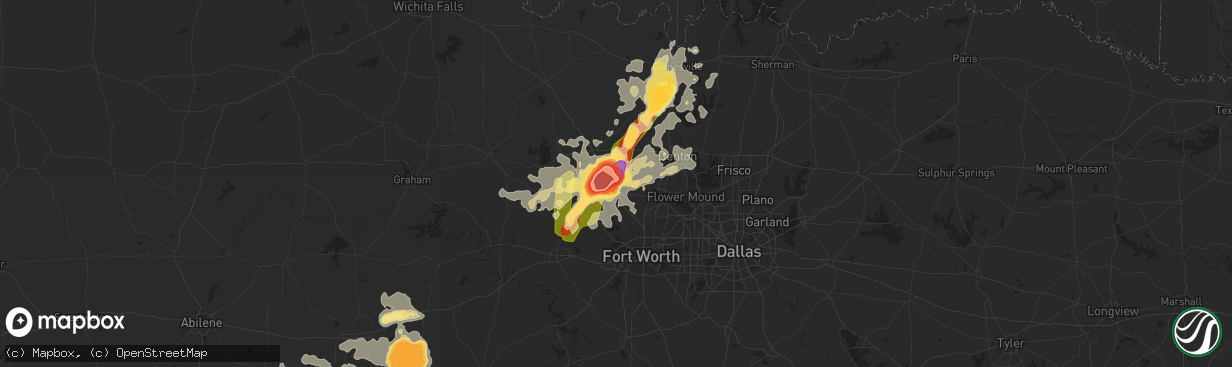
Hail
2,590
Estimated number of impacted properties by a 1.00" hail or larger1,792
Estimated number of impacted properties by a 1.75" hail or larger2,582
Estimated number of impacted properties by a 2.50" hail or largerStorm reports in Rhome, TX
Rhome, TX
| Date | Description |
|---|---|
| 05/07/20156:58 PM CDT | Power poles down |
| 05/07/20156:55 PM CDT | Double wide trailer and rvs destroyed... 4 inch to 20 inch trees uprooted at hwy 4421 at hwy 4420 |
| 05/07/20156:50 PM CDT | Barn destroyed at 3304 cr 2264 |
| 05/07/20156:45 PM CDT | 4 to 5 mobile homes damaged beyond repair in heritage creek |
| 05/07/20156:40 PM CDT | Softball sized hail |
| 05/07/20156:35 PM CDT | Tennis ball sized hail near hwy 287 in new fairview |
| 05/07/20156:24 PM CDT | Quarter size hail in aurora |
All States Impacted by Hail Map on May 7, 2015
All Cities Impacted by Hail Map on May 7, 2015
- Ellinwood, KS
- Chase, KS
- Matador, TX
- Wymore, NE
- Blue Springs, NE
- Beatrice, NE
- Rising Star, TX
- May, TX
- Brownwood, TX
- Childress, TX
- Pilot Point, TX
- Hays, KS
- Ness City, KS
- Jetmore, KS
- Hanston, KS
- Bazine, KS
- Chico, TX
- Bowie, TX
- Sunset, TX
- Jacksboro, TX
- Decatur, TX
- Rhome, TX
- Boyd, TX
- Hobart, OK
- Roosevelt, OK
- Humboldt, NE
- Du Bois, NE
- Ramah, CO
- Rush, CO
- Wright, KS
- Dodge City, KS
- Seymour, TX
- Muenster, TX
- Tulia, TX
- Happy, TX
- Glasco, KS
- Delphos, KS
- Cisco, TX
- Fort Worth, TX
- Quanah, TX
- Lorenzo, TX
- Ralls, TX
- Valley View, TX
- Osborne, KS
- Krum, TX
- Gainesville, TX
- Ponder, TX
- Era, TX
- Lindsay, TX
- Sanger, TX
- Lone Wolf, OK
- Bridgeport, TX
- Cimarron, KS
- Moran, TX
- Springtown, TX
- Justin, TX
- Newark, TX
- Holliday, TX
- Comanche, TX
- Blanket, TX
- Hollenberg, KS
- Morrowville, KS
- Ranger, TX
- Baird, TX
- Wellington, TX
- Azle, TX
- Weatherford, TX
- Lueders, TX
- Eldorado, OK
- Afton, TX
- Usaf Academy, CO
- Colorado Springs, CO
- Paradise, TX
- Haslet, TX
- Lyons, KS
- Sidney, TX
- Cross Plains, TX
- Kit Carson, CO
- Port Huron, MI
- Mingus, TX
- De Leon, TX
- Gorman, TX
- Desdemona, TX
- Levelland, TX
- Littlefield, TX
- Ellis, KS
- Plainview, TX
- Raymond, KS
- Harbor Beach, MI
- Applegate, MI
- Croswell, MI
- Spearville, KS
- Lockney, TX
- Hale Center, TX
- Solomon, KS
- St John, KS
- Odell, NE
- Eastland, TX
- Carbon, TX
- Lexington, MI
- Walsenburg, CO
- Simla, CO
- Bryson, TX
- Bellevue, TX
- Endicott, NE
- Priddy, TX
- Sterling, NE
- Sicily Island, LA
- Duke, OK
- Macksville, KS
- Larned, KS
- Clifton, KS
- Linn, KS
- Blair, OK
- Mangum, OK
- Garfield, KS
- Kinsley, KS
- Early, TX
- Chillicothe, TX
- Floydada, TX
- Hugo, CO
- Karval, CO
- Perrin, TX
- Tecumseh, NE
- Junction City, KS
- Calhan, CO
- Breckenridge, TX
- Graham, TX
- Offerle, KS
- Rule, TX
- Ransom, KS
- Iuka, KS
- Gould, OK
- Cheyenne Wells, CO
- Jermyn, TX
- Webster, IA
- Kim, CO
- Red Oak, IA
- Emerson, IA
- Zephyr, TX
- Griswold, IA
- Henderson, IA
- Branson, CO
- Loco, OK
- Ringling, OK
- Wichita Falls, TX
- Strawn, TX
- Mullin, TX
- Anson, TX
- Washington, KS
- Gorham, KS
- Russell, KS
- Paradise, KS
- Hanover, KS
- Harrisonburg, LA
- Arapahoe, CO
- Miltonvale, KS
- Model, CO
- Minneapolis, KS
- Coleman, TX
- Pratt, KS
- Electra, TX
- Iowa Park, TX
- Keller, TX
- Weinert, TX
- Hollis, OK
- Peyton, CO
- Avoca, TX
- Sadler, TX
- Whitesboro, TX
- Poolville, TX
- Detroit, MI
- Claflin, KS
- Elliott, IA
- Hastings, IA
- Carson, IA
- Agate, CO
- Newcastle, TX
- Crowell, TX
- Bushton, KS
- Victoria, KS
- Walker, KS
- Geneseo, KS
- Aubrey, TX
- Sigourney, IA
- Tell, TX
- Erick, OK
- Diller, NE
- Cuba, KS
- Dublin, TX
- Dawson, NE
- Wisner, LA
- Loving, TX
- Elbert, CO
- Burkett, TX
- Paducah, TX
- Godley, TX
- Texola, OK
- Hamtramck, MI
- Highland Park, MI
- Emporia, KS
- Munday, TX
- Walsh, CO
- Argyle, TX
- Lewisville, TX
- Roanoke, TX
- Fort Cobb, OK
- Carnegie, OK
- Palmer, KS
- Stamford, TX
- Avondale, CO
- Pueblo, CO
- Campo, CO
- Sheridan Lake, CO
- Wild Horse, CO
- Denton, TX
- Silverton, TX
- Knox City, TX
- Excello, MO
- Wildorado, TX
- Roby, TX
- McCaulley, TX
- Portales, NM
- Malvern, IA
- Old Glory, TX
- Oklahoma City, OK
- Norman, OK
- Haskell, TX
- Bremen, KS
- Adams, NE
- Hudson, KS
- Alvord, TX
- Rosston, TX
- Forestburg, TX
- Thackerville, OK
- Hamilton, TX
- Kingston, OK
- Midkiff, TX
- Steele City, NE
- Dodson, TX
- Throckmorton, TX
- Goodwell, OK
- Texhoma, OK
- Marysville, KS
- Crosbyton, TX
- Macedonia, IA
- Albany, TX
- Matheson, CO
- Clyde, KS
- Morganville, KS
- Gotebo, OK
- Salina, KS
- Merkel, TX
- O'Brien, TX
- Collinsville, TX
- Verdon, NE
- Grandfield, OK
- Cordell, OK
- Mountain View, OK
- Pawnee Rock, KS
- Sylvester, TX
- Fowler, CO
- Rocky Ford, CO
- La Junta, CO
- Spur, TX
- Kress, TX
- Montezuma, KS
- Copeland, KS
- Brownell, KS
- Great Bend, KS
- Olney, TX
- Salem, NE
- Falls City, NE
- Bern, KS
- Seneca, KS
- Roaring Springs, TX
- Dickens, TX
- Petersburg, TX


