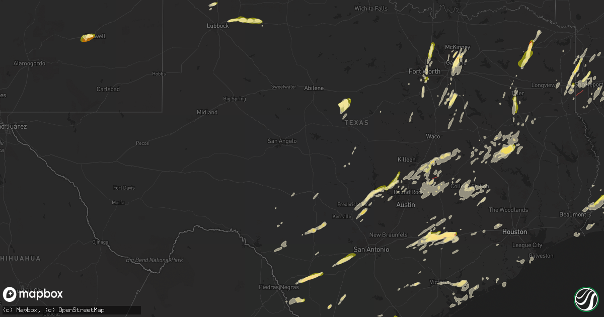
Hail Map in Texas on May 6, 2025
Get this storm
May 6 map
$229
one time, instant access
Download today. No call, no setup
Keep the $229
Bought the map and want the full workflow? Apply the entire $229 to a subscription within 7 days. None of it is wasted.
Every map, not just this one
This buys you this map. Subscription and you get every map we run, in the markets you choose from a few cities to whole states to nationwide. Plus real-time alerts the moment a storm fires.
Contact data
Name, contact info, occupancy, even credit band for addresses in the footprint. You go from where it hit to who to call.
Become the source they trust
Unlimited branding weather history reports on demand. You already have the documented answer ready for the property owner, and you are the one who showed up with it.
Property data and RoofTrace estimates
Pull up any address you have got, its value and the exact code rules for that jurisdiction, straight from One Click Code. Then RoofTrace estimates the squares, pitch, and roof value, priced the way you price.
Storm reports in Texas
Texas
| Date | Description |
|---|---|
| 05/06/20256:42 PM CDT | A local report indicates 1.00 inch wind near Lorenzo |
| 05/06/20256:35 PM CDT | Brick facade of an abandoned building blown down by thunderstorm winds. Media relayed photo... Time estimated from radar. |
| 05/06/20255:25 PM CDT | Emergency management reported golf ball size hail in weimar. |
| 05/06/20255:15 PM CDT | Time estimated via radar. |
| 05/06/20255:15 PM CDT | A local report indicates 1.25 inch wind near 4 NW Dimmitt |
| 05/06/20255:14 PM CDT | Public reports nickel to quarter sized hail. |
| 05/06/20254:26 PM CDT | Broadcast media relayed a report of ping pong ball sized hail in flatonia. |
| 05/06/20254:22 PM CDT | Picture via social media. Time estimated via radar. |
| 05/06/20254:14 PM CDT | A local report indicates 1.00 inch wind near 7 ESE Friona |
| 05/06/20253:23 PM CDT | Social media report of quarter sized hail in waskom. |
| 05/06/20252:40 PM CDT | Report of a tree down on fm 1798 west of us 259. |
| 05/06/20252:40 PM CDT | Report of a few trees down on texas 315 north of fm 95. |
| 05/06/20252:38 PM CDT | Report of a tree down on cr 308 near the intersection with fm 840. |
| 05/06/20251:57 PM CDT | Several trees down on fm 837 blocking the road between hwy 19 and hwy 155. Reported via vfd. |
| 05/06/20251:48 PM CDT | Corrects previous flash flood report from 1 e bullard. Report of multiple trees down on a house in the area of pecan valley drive. |
| 05/06/20251:44 PM CDT | Report of multiple trees down on fm 344. |
| 05/06/20251:28 PM CDT | Emergency manager reports trees on homes and powerlines down in frankston. Time estimated by radar. |
| 05/06/20251:12 PM CDT | Broadcast media relays social media pictures of structural damage to a brick building and another home with damage to the roof and damaged trees in yard in jewett. Time |
| 05/06/20251:11 PM CDT | Report from mping. |
| 05/06/20251:06 PM CDT | Emergency manager relays report from dispatch that a large oak tree is blocking the road. Time estimated by radar. |
| 05/06/20251:06 PM CDT | Time estimated via radar. |
| 05/06/20251:03 PM CDT | Em reports tree blocking road on hwy 164 and fm 1953 east of groesbeck. Time estimated by radar. |
| 05/06/20251:01 PM CDT | Social media report of a tree down in queen... Tx. |
| 05/06/20251:00 PM CDT | Emergency manager relays spotter report of tree blocking the road at lcr 420 east of groesbeck. Time estimated by radar. |
| 05/06/20251:00 PM CDT | Facebook photos showed two large barns with roofs blown off and one shop with overhead doors partially blown in on fm 1469 near pr 3550 north of marquez. |
| 05/06/202512:52 PM CDT | Report of quarter sized hail in gresham... Tx. |
| 05/06/202512:45 PM CDT | Report of quarter sized hail in flint... Tx. |
| 05/06/202512:42 PM CDT | Delayed report. Em reports tree damage across county - from calvert to hearne and up us 79 into leon county. Time estimated by radar. |
| 05/06/202510:49 AM CDT | Report from mping: ping pong ball |
| 05/06/202510:46 AM CDT | Report from mping: half dollar |
| 05/06/202510:45 AM CDT | 1 inch hail in sachse. |
| 05/06/202510:40 AM CDT | Report from mping: quarter |
| 05/06/202510:36 AM CDT | Social media report of 1.5 inch hail around hwy 78 and 5th street in sachse. Time estimated by radar. |
| 05/06/202510:35 AM CDT | Social media picture of half dollar sized hail in north garland. |
| 05/06/202510:30 AM CDT | 1 to 1.25 inch diameter hail measured by public. Picture relayed via social media. |
| 05/06/202510:30 AM CDT | A local report indicates 1.00 inch wind near 4 WNW Andice |
| 05/06/202510:28 AM CDT | Spotter reports 1 inch hail in garland. |
| 05/06/202510:24 AM CDT | Delayed report. Social media image of hail around 1.5 inches in bardwell. |
| 05/06/202510:12 AM CDT | Report from mping: quarter |
| 05/06/20259:34 AM CDT | 1 inch hail reported at the denton public library north branch. |
| 05/06/20259:21 AM CDT | Photo on x of up to quarter size hail in argyle. |
| 05/06/20259:12 AM CDT | Em reports 1 inch hail in roanoke. |
| 05/06/20258:44 AM CDT | Report from mping: quarter |
| 05/06/20252:23 AM CDT | Zapata county sheriffs office stated public reported hail generally the size of golf balls with some hail the size of softballs in the city of san ygnacio. |
| 05/05/20259:20 PM CDT | Off duty nws employee sends photos and video of hail the largest of which was 2 inches in diameter. |
| 05/05/20259:13 PM CDT | Report from mping: ping pong ball |
| 05/05/20257:09 PM CDT | A local report indicates 1.00 inch wind near 2 WNW Crosbyton |
| 05/05/20257:00 PM CDT | Social media report of 1.5 inch in fronton tx. Time estimated by radar. |
All States Impacted by Hail Map on May 6, 2025
Cities Impacted by Hail Map on May 6, 2025
- Cisco, TX
- Cross Plains, TX
- Brownwood, TX
- Fredericksburg, TX
- Rising Star, TX
- Rocksprings, TX
- Stonewall, TX
- Carbon, TX
- Johnson City, TX
- Round Mountain, TX
- Clifton, TX
- Sonora, TX
- Cleburne, TX
- Rio Vista, TX
- Horseshoe Bay, TX
- Marble Falls, TX
- Llano, TX
- Meridian, TX
- Joshua, TX
- Burleson, TX
- Keene, TX
- Spicewood, TX
- Fort Worth, TX
- Bertram, TX
- Liberty Hill, TX
- Brackettville, TX
- Leander, TX
- Fredonia, TX
- Voca, TX
- Richland Springs, TX
- San Saba, TX
- Haltom City, TX
- Junction, TX
- Colleyville, TX
- Keller, TX
- Roanoke, TX
- Argyle, TX
- Justin, TX
- Flower Mound, TX
- Denton, TX
- Brownsboro, TX
- Boerne, TX
- Comfort, TX
- Crowley, TX
- Italy, TX
- Waxahachie, TX
- Milford, TX
- North Richland Hills, TX
- Southlake, TX
- Hurst, TX
- Jarrell, TX
- Georgetown, TX
- Florence, TX
- Leakey, TX
- Camp Wood, TX
- Lancaster, TX
- Salado, TX
- Hye, TX
- Mount Calm, TX
- Coolidge, TX
- Hunt, TX
- Blooming Grove, TX
- Frost, TX
- Holland, TX
- Cresson, TX
- Granbury, TX
- Dawson, TX
- Hubbard, TX
- Dallas, TX
- Bartlett, TX
- Belton, TX
- Mesquite, TX
- Dublin, TX
- Balch Springs, TX
- Rogers, TX
- Temple, TX
- Garland, TX
- Vanderpool, TX
- Ennis, TX
- Little River Academy, TX
- Purdon, TX
- Sunnyvale, TX
- Wortham, TX
- Rowlett, TX
- Barry, TX
- Corsicana, TX
- Lindale, TX
- Winnsboro, TX
- Chandler, TX
- Richland, TX
- Crowley, LA
- Estherwood, LA
- Gueydan, LA
- Morse, LA
- Sachse, TX
- Wylie, TX
- Richardson, TX
- Plano, TX
- Leesburg, TX
- Pittsburg, TX
- Gilmer, TX
- Scroggins, TX
- Rayne, LA
- Branch, LA
- Church Point, LA
- Burlington, TX
- Grand Chenier, LA
- Creole, LA
- Dripping Springs, TX
- Rockwall, TX
- Allen, TX
- Knippa, TX
- Uvalde, TX
- Rosebud, TX
- Lott, TX
- Egan, LA
- Hawkins, TX
- Princeton, TX
- Kaplan, LA
- Powell, TX
- Crystal City, TX
- Nevada, TX
- Mount Vernon, TX
- Mount Pleasant, TX
- Winfield, TX
- Duson, LA
- Cedar Park, TX
- Mckinney, TX
- Forreston, TX
- Round Rock, TX
- Austin, TX
- New Iberia, LA
- Granger, TX
- Farmersville, TX
- La Pryor, TX
- Batesville, TX
- Saint Martinville, LA
- Lafayette, LA
- Blanco, TX
- Reagan, TX
- Manheim, PA
- Washington, LA
- Plaucheville, LA
- Palmetto, LA
- Bunkie, LA
- Maurice, LA
- Taylor, TX
- Marlin, TX
- Loreauville, LA
- Bremond, TX
- Thorndale, TX
- Buckholts, TX
- Kosse, TX
- Lebanon, PA
- Thrall, TX
- Coupland, TX
- Talco, TX
- Simmesport, LA
- Myerstown, PA
- Marshall, TX
- Rockdale, TX
- Cameron, TX
- Davilla, TX
- Waskom, TX
- Avery, TX
- Annona, TX
- Lettsworth, LA
- Bethel, PA
- Rehrersburg, PA
- Richland, PA
- Bernville, PA
- Womelsdorf, PA
- Monterey, LA
- D Hanis, TX
- Batchelor, LA
- Woodville, MS
- Jeanerette, LA
- Yancey, TX
- Hondo, TX
- Devine, TX
- Karnack, TX
- Vivian, LA
- Mooringsport, LA
- Jacksonville, TX
- Schuylkill Haven, PA
- Rusk, TX
- Auburn, PA
- Pine Grove, PA
- Tyler, TX
- Flint, TX
- Elgin, TX
- Oil City, LA
- Bullard, TX
- Crosby, MS
- Gloster, MS
- Natchez, MS
- Linden, TX
- Jefferson, TX
- Atlanta, TX
- Lexington, TX
- Marquez, TX
- Rodessa, LA
- Bivins, TX
- Ida, LA
- Franklin, TX
- Plaquemine, LA
- Whitehouse, TX
- Milano, TX
- Caldwell, TX
- Grosse Tete, LA
- Hosston, LA
- Castroville, TX
- La Coste, TX
- Doddridge, AR
- Reading, PA
- Larue, TX
- De Berry, TX
- Buffalo, TX
- Jewett, TX
- Roxie, MS
- Oakwood, TX
- Centerville, TX
- Bradley, AR
- Fouke, AR
- Gause, TX
- White Castle, LA
- Shreveport, LA
- Elkhart, TX
- Bryan, TX
- Hearne, TX
- Gilliam, LA
- Normangee, TX
- Leona, TX
- Plain Dealing, LA
- Benton, LA
- Grapeland, TX
- Elm Grove, LA
- Taylor, AR
- Haughton, LA
- Coushatta, LA
- Grand Cane, LA
- Barton, NY
- Nichols, NY
- Owego, NY
- Roswell, NM
- Doyline, LA
- Bossier City, LA
- Saint Gabriel, LA
- Gloster, LA
- Frierson, LA
- Madisonville, TX
- Midway, TX
- Carville, LA
- Heflin, LA
- Sibley, LA
- Crockett, TX
- Alto, TX
- Newark Valley, NY
- Berkshire, NY
- Hall Summit, LA
- Ringgold, LA
- Cushing, TX
- Minden, LA
- Candor, NY
- Sunshine, LA
- Baton Rouge, LA
- Athens, LA
- Somerville, TX
- El Dorado, AR
- Lovelady, TX
- Denham Springs, LA
- Prairieville, LA
- College Station, TX
- Snook, TX
- Pollock, LA
- Homer, LA
- Gibsland, LA
- Ashland, LA
- Saline, LA
- Jonesboro, LA
- Gonzales, TX
- Waelder, TX
- Pen Argyl, PA
- Bangor, PA
- Nazareth, PA
- Keithville, LA
- Harwood, TX
- Iola, TX
- Immokalee, FL
- Castor, LA
- Smithville, TX
- Flatonia, TX
- Jena, LA
- Bienville, LA
- Kennard, TX
- Walker, LA
- Livingston, LA
- Newmanstown, PA
- Lititz, PA
- Schaefferstown, PA
- Fredericksburg, PA
- Jonesville, LA
- West Monroe, LA
- Chatham, LA
- Sikes, LA
- Anderson, TX
- Orange, TX
- West Point, TX
- La Grange, TX
- Muldoon, TX
- Olla, LA
- Bernice, LA
- Summerfield, LA
- Eros, LA
- Giddings, TX
- Rayville, LA
- Cost, TX
- Columbia, LA
- Navasota, TX
- Henderson, NV
- Bedias, TX
- Ferriday, LA
- Friona, TX
- Hereford, TX
- Starks, LA
- Vinton, LA
- Vidalia, LA
- Mangham, LA
- Oak Ridge, LA
- Holden, LA
- Albany, LA
- Springfield, LA
- Dequincy, LA
- Shiner, TX
- Labelle, FL
- Sulphur, LA
- Schulenburg, TX
- Fayetteville, TX
- Round Top, TX
- Moulton, TX
- Red Oak, TX
- Dodson, LA
- Alva, FL
- Maypearl, TX
- Palmer, TX
- Dimmitt, TX
- Centreville, MS
- Liberty, MS
- Clewiston, FL
- Kenansville, FL
- Richards, TX
- Westlake, LA
- Lake Charles, LA
- Moore Haven, FL
- Florien, LA
- Smithdale, MS
- Okeechobee, FL
- Iowa, LA
- Washington, TX
- Kinder, LA
- Glen Spey, NY
- Matamoras, PA
- Millrift, PA
- Milford, PA
- Sparrow Bush, NY
- Weimar, TX
- Ragley, LA
- Columbus, TX
- Laughlin, NV
- Cal Nev Ari, NV
- Elton, LA
- Singer, LA
- Vero Beach, FL
- Jamestown, LA
- Dubberly, LA
- Arcadia, LA
- Quitman, LA
- Simsboro, LA
- Ruston, LA
- Grambling, LA
- Choudrant, LA
- Downsville, LA
- Monroe, LA
- Calhoun, LA
- Collinston, LA
- Farmerville, LA
- Sterlington, LA
- Summit, MS
- Nipton, CA
- Welsh, LA
- Roanoke, LA
- Lake Wales, FL
- Jennings, LA
- Hallettsville, TX
- Searchlight, NV
- Jean, NV
- Merryville, LA
- Woodridge, NY
- Fallsburg, NY
- Hart, TX
- Epps, LA
- Delhi, LA
- Baskin, LA
- Sondheimer, LA
- Tallulah, LA
- Bell City, LA
- Idalou, TX
- Lorida, FL
- Oakland, TX
- Basile, LA
- Iota, LA
- Lorenzo, TX
- Ralls, TX
- Fort Mohave, AZ
- Bullhead City, AZ
- Kress, TX
- Lake Placid, FL
- Venus, FL
- Eunice, LA
- Mohave Valley, AZ
- Plainview, TX
- Abernathy, TX
- Hale Center, TX
- Cuero, TX
- Olton, TX
- Lacassine, LA
- Lake Arthur, LA
- Cameron, LA
- Fort Meade, FL
- Scott, LA
- Crosbyton, TX
- Sunset, LA
- Carencro, LA
- Arnaudville, LA
- Beeville, TX
- Kenedy, TX
- Brookshire, TX
- Sealy, TX
- Bowling Green, FL
- Dickens, TX
- Opelousas, LA
- Breaux Bridge, LA
- Mcadoo, TX
- Yorktown, TX
- Freer, TX
- George West, TX
- Mermentau, LA
- Katy, TX
- Goliad, TX
- Garwood, TX
- Roma, TX
- Cypress, TX
- Houston, TX
- Laredo, TX
- Mirando City, TX
- Spur, TX
- Maringouin, LA
- Bruni, TX
- Rosedale, LA
- Port Allen, LA
- Orange Grove, TX
- Richmond, TX
- Geismar, LA
- Sandia, TX
- Addis, LA
- Brusly, LA
- Gonzales, LA
- San Ygnacio, TX
- Zapata, TX
- Hebbronville, TX
- Victoria, TX
- Mathis, TX
- Abbeville, LA
- Bloomington, TX
- Inez, TX
- Edna, TX
- Sinton, TX
- Odem, TX
- Donaldsonville, LA
- Youngsville, LA
- Lolita, TX
- Needles, CA
- Delcambre, LA
- Erath, LA
- Franklin, LA
- Allentown, PA
- Emmaus, PA
- Center Valley, PA
- Coopersburg, PA
- Macungie, PA
- Zionsville, PA
- Whitehall, PA
- Bethlehem, PA
- Bath, PA
- Coplay, PA
- Northampton, PA
- Catasauqua, PA
- Eagle Pass, TX
- Carrizo Springs, TX
- Encino, TX
- Falfurrias, TX
- Sarita, TX
- Riviera, TX
- San Diego, TX
- Kingsville, TX
- Guerra, TX
- Asherton, TX
- Concepcion, TX
- Realitos, TX
- Cotulla, TX
- Las Vegas, NV
- Premont, TX
- Port Arthur, TX
- Seadrift, TX
- Port O'Connor, TX
- Bay City, TX
- Palacios, TX
- Port Lavaca, TX
- Danbury, TX
- Freeport, TX
- Liverpool, TX
- Galveston, TX
- Hitchcock, TX
- Baldwin, LA


