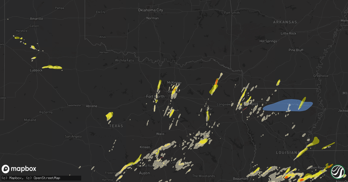
Hail Map on May 6, 2025
Get this storm
May 6 map
$229
one time, instant access
Download today. No call, no setup
Keep the $229
Bought the map and want the full workflow? Apply the entire $229 to a subscription within 7 days. None of it is wasted.
Every map, not just this one
This buys you this map. Subscription and you get every map we run, in the markets you choose from a few cities to whole states to nationwide. Plus real-time alerts the moment a storm fires.
Contact data
Name, contact info, occupancy, even credit band for addresses in the footprint. You go from where it hit to who to call.
Become the source they trust
Unlimited branding weather history reports on demand. You already have the documented answer ready for the property owner, and you are the one who showed up with it.
Property data and RoofTrace estimates
Pull up any address you have got, its value and the exact code rules for that jurisdiction, straight from One Click Code. Then RoofTrace estimates the squares, pitch, and roof value, priced the way you price.
States Impacted by Hail Map on May 6, 2025
Storm reports
Louisiana
| Date | Description |
|---|---|
| 05/06/20255:39 PM CDT | Quarter size hail reported by public north of livingston... La. |
| 05/06/20255:34 PM CDT | Public reported quarter size hail near walker... La. |
| 05/06/20255:33 PM CDT | Photo received via social media of marble to quarter size hail. |
| 05/06/20255:32 PM CDT | Report of a tree down on top of a house in the tanglewood subdivision. |
| 05/06/20255:31 PM CDT | Report of trees down on walker rd. |
| 05/06/20255:30 PM CDT | Report of power lines down on martin tram rd. |
| 05/06/20255:27 PM CDT | Report of roof blown off house... Trees down at intersection of red cut loop and red cut rd. |
| 05/06/20255:26 PM CDT | Power pole down along north 7th st. |
| 05/06/20255:25 PM CDT | Tree down on pennington rd near union grove ch rd. |
| 05/06/20255:22 PM CDT | Power pole snapped along rainbow dr. |
| 05/06/20255:20 PM CDT | Tree down in the road hwy 828 near willie brantley rd. |
| 05/06/20255:20 PM CDT | Tree down on a house on ervin cotton rd. |
| 05/06/20255:13 PM CDT | Report of a tree down on hwy 552 near henry rd. |
| 05/06/20255:12 PM CDT | Tree down on downsville rd near hamilton rd. |
| 05/06/20255:12 PM CDT | Tree down on hwy 15 near arthur mcdaniel rd. |
| 05/06/20255:10 PM CDT | Damage to home on flat creek rd. |
| 05/06/20254:45 PM CDT | Social media photo of a tree down on rigmaiden cemetery road. Time estimated by radar. |
| 05/06/20254:45 PM CDT | Photo receive of quarter size hail in dequincy. |
| 05/06/20254:43 PM CDT | Report of tree down across hwy 557 near elliot rd. |
| 05/06/20254:34 PM CDT | A local report indicates 1.00 inch wind near 3 ESE Mer Rouge |
| 05/06/20254:28 PM CDT | Tree down across highway 507 near highway 71. |
| 05/06/20254:25 PM CDT | Tree down across highway 480 near the red river/natchitoches parish line. |
| 05/06/20254:22 PM CDT | Tree down across highway 784 near grand bayou. |
| 05/06/20253:54 PM CDT | Trees down across highway 71 near the crossroads community. |
| 05/06/20253:53 PM CDT | Near ping pong ball sized hail fell near the city of livingston. |
| 05/06/20253:45 PM CDT | Social media report of quarter sized hail in elm grove. |
| 05/06/20253:44 PM CDT | Report of a tree down on hall rd. |
| 05/06/20253:33 PM CDT | Trees were snapped along woolworth road south of walnut hill elementary/middle school near the entrance to the caddo parish landfi |
| 05/06/20253:33 PM CDT | Trees were snapped along woolworth road south of walnut hill elementary/middle school near the entrance to the caddo parish landfill. A radar indicated tds was depicted |
| 05/06/20253:30 PM CDT | A comment on a social media post showed quarter sized hail south of walker. |
| 05/06/20253:23 PM CDT | Report of tree down on sr 172 near blueberry trail. |
| 05/06/20253:12 PM CDT | Report of a tree down on la-126 near the natchitoches/winn parish line. |
| 05/06/20252:44 PM CDT | Broadcast media reports quarter sized hail at lexington estates in baton rouge. |
| 05/06/20252:16 PM CDT | Social media report of quarter sized hail in benton. |
| 05/06/20251:55 PM CDT | Social media report of quarter sized hail near northwood high school in blanchard. |
| 05/06/20251:44 PM CDT | Iberville parish office of homeland security and emergency preparedness relayed multiple reports of quarter sized hail in bayou sorrel. |
| 05/06/202512:59 PM CDT | Report from mping: half dollar |
| 05/06/202512:55 PM CDT | Social media report of quarter size hail in loreauville. |
| 05/06/202512:35 PM CDT | Corrects previous hail report from loreauville. Social media report of quarter size hail in loreauville. |
| 05/06/202512:20 PM CDT | Social media report of quarter size hail. |
| 05/06/202511:59 AM CDT | Broadcast media reports hail in west lafayette. |
| 05/06/202511:42 AM CDT | Photo received of ping pong size hail. Time estimated by radar. |
| 05/06/202511:42 AM CDT | Photo received of quarter size hail in loreauville. Time estimated by radar. |
| 05/06/202511:40 AM CDT | Fb photo showing large ping pong to golf ball size hail scattered around the cane run golf course. |
| 05/06/202511:28 AM CDT | Social media photo of quarter size hail at duson. |
| 05/06/202511:13 AM CDT | Photo received of quarter to ping pong ball size hail at crowley. |
| 05/06/202511:09 AM CDT | Social media photo of quarter size hail at branch. |
| 05/06/202511:07 AM CDT | Photos received of golf ball size hail at lyons point. Time estimated by radar. |
| 05/05/202511:30 PM CDT | Mesonet station xptn pontchartrain causeway. |
| 05/05/20258:53 PM CDT | A local report indicates 1.25 inch wind near 2 N Carville |
| 05/05/20258:45 PM CDT | Fb report of large trees blown down near oakdale. |
| 05/05/20258:18 PM CDT | Report of a carport blown down onto a vehicle. Carport destroyed. Time estimated by radar. |
| 05/05/20258:06 PM CDT | Report of tree down in boyce. Time estimated by radar. |
| 05/05/20257:20 PM CDT | Emergency manager reports numerous trees down between sunset and leonville. |
| 05/05/20257:17 PM CDT | Report of tree down in deville. Time estimated from radar. |
| 05/05/20257:14 PM CDT | Emergency manager reports quarter size hail in grand coteau. |
| 05/05/20257:13 PM CDT | Vehicle hit a tree that had fallen onto hwy 112 at turner rd. Time estimated from radar. |
| 05/05/20257:10 PM CDT | A tree was blown down onto power lines on highway 127 south at white sulphur springs road in the rogers community. |
Arizona
| Date | Description |
|---|---|
| 05/06/20256:58 PM CDT | Quarter sized hail reported in fort mohave. |
| 05/06/20256:45 PM CDT | Video from social media. A small rotating debris field rips a few shingles off a roof and sends a trash can into the air. |
Mississippi
| Date | Description |
|---|---|
| 05/06/20255:15 PM CDT | Social media post showed hail completely covering the ground in liberty. |
| 05/06/20254:45 PM CDT | Tree downed across n palestine rd near intersection with duck pond rd. |
| 05/06/20253:22 AM CDT | Trees downed at camelot apartments... Causing damage to one building. Likely due to wake low. Gust of 37mph occurred at this time at hez awos site. |
| 05/05/202510:42 PM CDT | Trees downed in kokomo and one in columbia. |
New Jersey
| Date | Description |
|---|---|
| 05/06/20253:40 PM CDT | A few trees down and wires down. Time estimated from radar. |
Texas
| Date | Description |
|---|---|
| 05/06/20256:42 PM CDT | A local report indicates 1.00 inch wind near Lorenzo |
| 05/06/20256:35 PM CDT | Brick facade of an abandoned building blown down by thunderstorm winds. Media relayed photo... Time estimated from radar. |
| 05/06/20255:25 PM CDT | Emergency management reported golf ball size hail in weimar. |
| 05/06/20255:15 PM CDT | Time estimated via radar. |
| 05/06/20255:15 PM CDT | A local report indicates 1.25 inch wind near 4 NW Dimmitt |
| 05/06/20255:14 PM CDT | Public reports nickel to quarter sized hail. |
| 05/06/20254:26 PM CDT | Broadcast media relayed a report of ping pong ball sized hail in flatonia. |
| 05/06/20254:22 PM CDT | Picture via social media. Time estimated via radar. |
| 05/06/20254:14 PM CDT | A local report indicates 1.00 inch wind near 7 ESE Friona |
| 05/06/20253:23 PM CDT | Social media report of quarter sized hail in waskom. |
| 05/06/20252:40 PM CDT | Report of a few trees down on texas 315 north of fm 95. |
| 05/06/20252:40 PM CDT | Report of a tree down on fm 1798 west of us 259. |
| 05/06/20252:38 PM CDT | Report of a tree down on cr 308 near the intersection with fm 840. |
| 05/06/20251:57 PM CDT | Several trees down on fm 837 blocking the road between hwy 19 and hwy 155. Reported via vfd. |
| 05/06/20251:48 PM CDT | Corrects previous flash flood report from 1 e bullard. Report of multiple trees down on a house in the area of pecan valley drive. |
| 05/06/20251:44 PM CDT | Report of multiple trees down on fm 344. |
| 05/06/20251:28 PM CDT | Emergency manager reports trees on homes and powerlines down in frankston. Time estimated by radar. |
| 05/06/20251:12 PM CDT | Broadcast media relays social media pictures of structural damage to a brick building and another home with damage to the roof and damaged trees in yard in jewett. Time |
| 05/06/20251:11 PM CDT | Report from mping. |
| 05/06/20251:06 PM CDT | Time estimated via radar. |
| 05/06/20251:06 PM CDT | Emergency manager relays report from dispatch that a large oak tree is blocking the road. Time estimated by radar. |
| 05/06/20251:03 PM CDT | Em reports tree blocking road on hwy 164 and fm 1953 east of groesbeck. Time estimated by radar. |
| 05/06/20251:01 PM CDT | Social media report of a tree down in queen... Tx. |
| 05/06/20251:00 PM CDT | Emergency manager relays spotter report of tree blocking the road at lcr 420 east of groesbeck. Time estimated by radar. |
| 05/06/20251:00 PM CDT | Facebook photos showed two large barns with roofs blown off and one shop with overhead doors partially blown in on fm 1469 near pr 3550 north of marquez. |
| 05/06/202512:52 PM CDT | Report of quarter sized hail in gresham... Tx. |
| 05/06/202512:45 PM CDT | Report of quarter sized hail in flint... Tx. |
| 05/06/202512:42 PM CDT | Delayed report. Em reports tree damage across county - from calvert to hearne and up us 79 into leon county. Time estimated by radar. |
| 05/06/202510:49 AM CDT | Report from mping: ping pong ball |
| 05/06/202510:46 AM CDT | Report from mping: half dollar |
| 05/06/202510:45 AM CDT | 1 inch hail in sachse. |
| 05/06/202510:40 AM CDT | Report from mping: quarter |
| 05/06/202510:36 AM CDT | Social media report of 1.5 inch hail around hwy 78 and 5th street in sachse. Time estimated by radar. |
| 05/06/202510:35 AM CDT | Social media picture of half dollar sized hail in north garland. |
| 05/06/202510:30 AM CDT | 1 to 1.25 inch diameter hail measured by public. Picture relayed via social media. |
| 05/06/202510:30 AM CDT | A local report indicates 1.00 inch wind near 4 WNW Andice |
| 05/06/202510:28 AM CDT | Spotter reports 1 inch hail in garland. |
| 05/06/202510:24 AM CDT | Delayed report. Social media image of hail around 1.5 inches in bardwell. |
| 05/06/202510:12 AM CDT | Report from mping: quarter |
| 05/06/20259:34 AM CDT | 1 inch hail reported at the denton public library north branch. |
| 05/06/20259:21 AM CDT | Photo on x of up to quarter size hail in argyle. |
| 05/06/20259:12 AM CDT | Em reports 1 inch hail in roanoke. |
| 05/06/20258:44 AM CDT | Report from mping: quarter |
| 05/06/20252:23 AM CDT | Zapata county sheriffs office stated public reported hail generally the size of golf balls with some hail the size of softballs in the city of san ygnacio. |
| 05/05/20259:20 PM CDT | Off duty nws employee sends photos and video of hail the largest of which was 2 inches in diameter. |
| 05/05/20259:13 PM CDT | Report from mping: ping pong ball |
| 05/05/20257:09 PM CDT | A local report indicates 1.00 inch wind near 2 WNW Crosbyton |
| 05/05/20257:00 PM CDT | Social media report of 1.5 inch in fronton tx. Time estimated by radar. |
Pennsylvania
| Date | Description |
|---|---|
| 05/06/20254:05 PM CDT | Trained spotter relays report of mostly small sized hail mixed in with some to quarters. Time estimated from radar. |
| 05/06/20253:45 PM CDT | Photo via social media of a large tree down blocking both lanes of pa route 512 between east bangor and mount bethel. Time estimated from radar. |
| 05/06/20253:28 PM CDT | Large tree down over half of the road. Radar-estimated time. |
| 05/06/20253:20 PM CDT | Also noted tree limbs down. |
| 05/06/20253:15 PM CDT | Tree down over wires. Radar-estimated time. |
| 05/06/20253:01 PM CDT | Tree down on a car along route 501 near the intersection with route 322. |
| 05/06/20252:51 PM CDT | Several videos received via social media confirm a tornado occurred near route 191 south of bangor. Time estimated. |
| 05/06/20252:51 PM CDT | Reports of minor trees and lines down along route 191 near bangor. Time estimated. |
| 05/06/20252:49 PM CDT | Em relays report of trees down in the area with damage near flicksville rd. Time estimated from radar. |
| 05/06/20252:47 PM CDT | An ef1 tornado with estimated maximum wind speeds of 80 to 90 mph occurred near bangor. The first damage was noted at a public works barn. Damage in this area was consi |
| 05/06/20251:51 PM CDT | Trees down on power lines along mill road in mahoning twp. Time estimated from radar. |
| 05/06/20251:30 PM CDT | Tree down blocking a lane of highway 6. Radar-estimated time. |
| 05/06/20251:25 PM CDT | Multiple trees and wires down along orchard rd. Time estimated from radar. |
| 05/06/20251:18 PM CDT | Alsace township: snyder rd and antietam rd. Tree down. Time estimated from radar. |
| 05/06/202512:43 PM CDT | Report of a large tree down blocking the roadway near the intersection of upland road and byrd road in marlborough twp. Time estimated from radar. |
| 05/06/202512:42 PM CDT | Microburst produced localized damage consisting of several snapped/downed pine trees. Peak estimated winds of 70-80 mph. |
| 05/06/202512:31 PM CDT | Tree blocking pa-183 south of summit station. |
| 05/06/202512:18 PM CDT | Broadcast media relays report of tree down on route 183. Time estimated from radar. |
| 05/06/202512:13 PM CDT | Quarter size hail falling at time of report. |
| 05/06/202512:03 PM CDT | Tree on wires in myerstown in the 300 block of south cherry street. |
New York
| Date | Description |
|---|---|
| 05/06/20255:54 PM CDT | Tree down on wires between gamble road and willow heights road. |
| 05/06/20254:00 PM CDT | Extensive tree damage in the town of hancock. Radar estimated time. |
| 05/06/20253:53 PM CDT | Tree down blocking one lane of road. |
| 05/06/20252:18 PM CDT | Wires down at skyline road and 17c. Radar-estimated time. |
Nevada
| Date | Description |
|---|---|
| 05/06/20253:30 PM CDT | Quarter sized hail measured at windmill and maryland. |
Arkansas
| Date | Description |
|---|---|
| 05/06/20253:17 PM CDT | Quarter sized hail reported at kard studio in el dorado. |
Florida
| Date | Description |
|---|---|
| 05/06/20255:30 PM CDT | A member of the broadcast media relayed a viewer report of ping pong ball sized hail in pioneer plantation. |
| 05/05/20257:45 PM CDT | *** 1 inj *** highlands co em relayed pictures of damage to 3 mob |
| 05/05/20257:45 PM CDT | *** 1 inj *** highlands co em relayed pictures of damage to 3 mobile homes in the francis one mobile estates community... With one minor injury reported. Damage mainly |
New Mexico
| Date | Description |
|---|---|
| 05/06/20253:06 PM CDT | A local report indicates 1.00 inch wind near 3 NNW Roswell |
| 05/06/20253:05 PM CDT | [landspout] spotter reported brief landspout to the northwest of roswell correctional facility. |
| 05/06/20253:00 PM CDT | Mostly pea to nickel size hail a few blocks southwest of downtown roswell. A few stones to ping-pong size were noted. |
Cities Impacted by Hail Map on May 6, 2025
- Cisco, TX
- Cross Plains, TX
- Brownwood, TX
- Fredericksburg, TX
- Rising Star, TX
- Rocksprings, TX
- Stonewall, TX
- Carbon, TX
- Johnson City, TX
- Round Mountain, TX
- Clifton, TX
- Sonora, TX
- Cleburne, TX
- Rio Vista, TX
- Horseshoe Bay, TX
- Marble Falls, TX
- Llano, TX
- Meridian, TX
- Joshua, TX
- Burleson, TX
- Keene, TX
- Spicewood, TX
- Fort Worth, TX
- Bertram, TX
- Liberty Hill, TX
- Brackettville, TX
- Leander, TX
- Fredonia, TX
- Voca, TX
- Richland Springs, TX
- San Saba, TX
- Haltom City, TX
- Junction, TX
- Colleyville, TX
- Keller, TX
- Roanoke, TX
- Argyle, TX
- Justin, TX
- Flower Mound, TX
- Denton, TX
- Brownsboro, TX
- Boerne, TX
- Comfort, TX
- Crowley, TX
- Italy, TX
- Waxahachie, TX
- Milford, TX
- North Richland Hills, TX
- Southlake, TX
- Hurst, TX
- Jarrell, TX
- Georgetown, TX
- Florence, TX
- Leakey, TX
- Camp Wood, TX
- Lancaster, TX
- Salado, TX
- Hye, TX
- Mount Calm, TX
- Coolidge, TX
- Hunt, TX
- Blooming Grove, TX
- Frost, TX
- Holland, TX
- Cresson, TX
- Granbury, TX
- Dawson, TX
- Hubbard, TX
- Dallas, TX
- Bartlett, TX
- Belton, TX
- Mesquite, TX
- Dublin, TX
- Balch Springs, TX
- Rogers, TX
- Temple, TX
- Garland, TX
- Vanderpool, TX
- Ennis, TX
- Little River Academy, TX
- Purdon, TX
- Sunnyvale, TX
- Wortham, TX
- Rowlett, TX
- Barry, TX
- Corsicana, TX
- Lindale, TX
- Winnsboro, TX
- Chandler, TX
- Richland, TX
- Crowley, LA
- Estherwood, LA
- Gueydan, LA
- Morse, LA
- Sachse, TX
- Wylie, TX
- Richardson, TX
- Plano, TX
- Leesburg, TX
- Pittsburg, TX
- Gilmer, TX
- Scroggins, TX
- Rayne, LA
- Branch, LA
- Church Point, LA
- Burlington, TX
- Grand Chenier, LA
- Creole, LA
- Dripping Springs, TX
- Rockwall, TX
- Allen, TX
- Knippa, TX
- Uvalde, TX
- Rosebud, TX
- Lott, TX
- Egan, LA
- Hawkins, TX
- Princeton, TX
- Kaplan, LA
- Powell, TX
- Crystal City, TX
- Nevada, TX
- Mount Vernon, TX
- Mount Pleasant, TX
- Winfield, TX
- Duson, LA
- Cedar Park, TX
- Mckinney, TX
- Forreston, TX
- Round Rock, TX
- Austin, TX
- New Iberia, LA
- Granger, TX
- Farmersville, TX
- La Pryor, TX
- Batesville, TX
- Saint Martinville, LA
- Lafayette, LA
- Blanco, TX
- Reagan, TX
- Manheim, PA
- Washington, LA
- Plaucheville, LA
- Palmetto, LA
- Bunkie, LA
- Maurice, LA
- Taylor, TX
- Marlin, TX
- Loreauville, LA
- Bremond, TX
- Thorndale, TX
- Buckholts, TX
- Kosse, TX
- Lebanon, PA
- Thrall, TX
- Coupland, TX
- Talco, TX
- Simmesport, LA
- Myerstown, PA
- Marshall, TX
- Rockdale, TX
- Cameron, TX
- Davilla, TX
- Waskom, TX
- Avery, TX
- Annona, TX
- Lettsworth, LA
- Bethel, PA
- Rehrersburg, PA
- Richland, PA
- Bernville, PA
- Womelsdorf, PA
- Monterey, LA
- D Hanis, TX
- Batchelor, LA
- Woodville, MS
- Jeanerette, LA
- Yancey, TX
- Hondo, TX
- Devine, TX
- Karnack, TX
- Vivian, LA
- Mooringsport, LA
- Jacksonville, TX
- Schuylkill Haven, PA
- Rusk, TX
- Auburn, PA
- Pine Grove, PA
- Tyler, TX
- Flint, TX
- Elgin, TX
- Oil City, LA
- Bullard, TX
- Crosby, MS
- Gloster, MS
- Natchez, MS
- Linden, TX
- Jefferson, TX
- Atlanta, TX
- Lexington, TX
- Marquez, TX
- Rodessa, LA
- Bivins, TX
- Ida, LA
- Franklin, TX
- Plaquemine, LA
- Whitehouse, TX
- Milano, TX
- Caldwell, TX
- Grosse Tete, LA
- Hosston, LA
- Castroville, TX
- La Coste, TX
- Doddridge, AR
- Reading, PA
- Larue, TX
- De Berry, TX
- Buffalo, TX
- Jewett, TX
- Roxie, MS
- Oakwood, TX
- Centerville, TX
- Bradley, AR
- Fouke, AR
- Gause, TX
- White Castle, LA
- Shreveport, LA
- Elkhart, TX
- Bryan, TX
- Hearne, TX
- Gilliam, LA
- Normangee, TX
- Leona, TX
- Plain Dealing, LA
- Benton, LA
- Grapeland, TX
- Elm Grove, LA
- Taylor, AR
- Haughton, LA
- Coushatta, LA
- Grand Cane, LA
- Barton, NY
- Nichols, NY
- Owego, NY
- Roswell, NM
- Doyline, LA
- Bossier City, LA
- Saint Gabriel, LA
- Gloster, LA
- Frierson, LA
- Madisonville, TX
- Midway, TX
- Carville, LA
- Heflin, LA
- Sibley, LA
- Crockett, TX
- Alto, TX
- Newark Valley, NY
- Berkshire, NY
- Hall Summit, LA
- Ringgold, LA
- Cushing, TX
- Minden, LA
- Candor, NY
- Sunshine, LA
- Baton Rouge, LA
- Athens, LA
- Somerville, TX
- El Dorado, AR
- Lovelady, TX
- Denham Springs, LA
- Prairieville, LA
- College Station, TX
- Snook, TX
- Pollock, LA
- Homer, LA
- Gibsland, LA
- Ashland, LA
- Saline, LA
- Jonesboro, LA
- Gonzales, TX
- Waelder, TX
- Pen Argyl, PA
- Bangor, PA
- Nazareth, PA
- Keithville, LA
- Harwood, TX
- Iola, TX
- Immokalee, FL
- Castor, LA
- Smithville, TX
- Flatonia, TX
- Jena, LA
- Bienville, LA
- Kennard, TX
- Walker, LA
- Livingston, LA
- Newmanstown, PA
- Lititz, PA
- Schaefferstown, PA
- Fredericksburg, PA
- Jonesville, LA
- West Monroe, LA
- Chatham, LA
- Sikes, LA
- Anderson, TX
- Orange, TX
- West Point, TX
- La Grange, TX
- Muldoon, TX
- Olla, LA
- Bernice, LA
- Summerfield, LA
- Eros, LA
- Giddings, TX
- Rayville, LA
- Cost, TX
- Columbia, LA
- Navasota, TX
- Henderson, NV
- Bedias, TX
- Ferriday, LA
- Friona, TX
- Hereford, TX
- Starks, LA
- Vinton, LA
- Vidalia, LA
- Mangham, LA
- Oak Ridge, LA
- Holden, LA
- Albany, LA
- Springfield, LA
- Dequincy, LA
- Shiner, TX
- Labelle, FL
- Sulphur, LA
- Schulenburg, TX
- Fayetteville, TX
- Round Top, TX
- Moulton, TX
- Red Oak, TX
- Dodson, LA
- Alva, FL
- Maypearl, TX
- Palmer, TX
- Dimmitt, TX
- Centreville, MS
- Liberty, MS
- Clewiston, FL
- Kenansville, FL
- Richards, TX
- Westlake, LA
- Lake Charles, LA
- Moore Haven, FL
- Florien, LA
- Smithdale, MS
- Okeechobee, FL
- Iowa, LA
- Washington, TX
- Kinder, LA
- Glen Spey, NY
- Matamoras, PA
- Millrift, PA
- Milford, PA
- Sparrow Bush, NY
- Weimar, TX
- Ragley, LA
- Columbus, TX
- Laughlin, NV
- Cal Nev Ari, NV
- Elton, LA
- Singer, LA
- Vero Beach, FL
- Jamestown, LA
- Dubberly, LA
- Arcadia, LA
- Quitman, LA
- Simsboro, LA
- Ruston, LA
- Grambling, LA
- Choudrant, LA
- Downsville, LA
- Monroe, LA
- Calhoun, LA
- Collinston, LA
- Farmerville, LA
- Sterlington, LA
- Summit, MS
- Nipton, CA
- Welsh, LA
- Roanoke, LA
- Lake Wales, FL
- Jennings, LA
- Hallettsville, TX
- Searchlight, NV
- Jean, NV
- Merryville, LA
- Woodridge, NY
- Fallsburg, NY
- Hart, TX
- Epps, LA
- Delhi, LA
- Baskin, LA
- Sondheimer, LA
- Tallulah, LA
- Bell City, LA
- Idalou, TX
- Lorida, FL
- Oakland, TX
- Basile, LA
- Iota, LA
- Lorenzo, TX
- Ralls, TX
- Fort Mohave, AZ
- Bullhead City, AZ
- Kress, TX
- Lake Placid, FL
- Venus, FL
- Eunice, LA
- Mohave Valley, AZ
- Plainview, TX
- Abernathy, TX
- Hale Center, TX
- Cuero, TX
- Olton, TX
- Lacassine, LA
- Lake Arthur, LA
- Cameron, LA
- Fort Meade, FL
- Scott, LA
- Crosbyton, TX
- Sunset, LA
- Carencro, LA
- Arnaudville, LA
- Beeville, TX
- Kenedy, TX
- Brookshire, TX
- Sealy, TX
- Bowling Green, FL
- Dickens, TX
- Opelousas, LA
- Breaux Bridge, LA
- Mcadoo, TX
- Yorktown, TX
- Freer, TX
- George West, TX
- Mermentau, LA
- Katy, TX
- Goliad, TX
- Garwood, TX
- Roma, TX
- Cypress, TX
- Houston, TX
- Laredo, TX
- Mirando City, TX
- Spur, TX
- Maringouin, LA
- Bruni, TX
- Rosedale, LA
- Port Allen, LA
- Orange Grove, TX
- Richmond, TX
- Geismar, LA
- Sandia, TX
- Addis, LA
- Brusly, LA
- Gonzales, LA
- San Ygnacio, TX
- Zapata, TX
- Hebbronville, TX
- Victoria, TX
- Mathis, TX
- Abbeville, LA
- Bloomington, TX
- Inez, TX
- Edna, TX
- Sinton, TX
- Odem, TX
- Donaldsonville, LA
- Youngsville, LA
- Lolita, TX
- Needles, CA
- Delcambre, LA
- Erath, LA
- Franklin, LA
- Allentown, PA
- Emmaus, PA
- Center Valley, PA
- Coopersburg, PA
- Macungie, PA
- Zionsville, PA
- Whitehall, PA
- Bethlehem, PA
- Bath, PA
- Coplay, PA
- Northampton, PA
- Catasauqua, PA
- Eagle Pass, TX
- Carrizo Springs, TX
- Encino, TX
- Falfurrias, TX
- Sarita, TX
- Riviera, TX
- San Diego, TX
- Kingsville, TX
- Guerra, TX
- Asherton, TX
- Concepcion, TX
- Realitos, TX
- Cotulla, TX
- Las Vegas, NV
- Premont, TX
- Port Arthur, TX
- Seadrift, TX
- Port O'Connor, TX
- Bay City, TX
- Palacios, TX
- Port Lavaca, TX
- Danbury, TX
- Freeport, TX
- Liverpool, TX
- Galveston, TX
- Hitchcock, TX
- Baldwin, LA