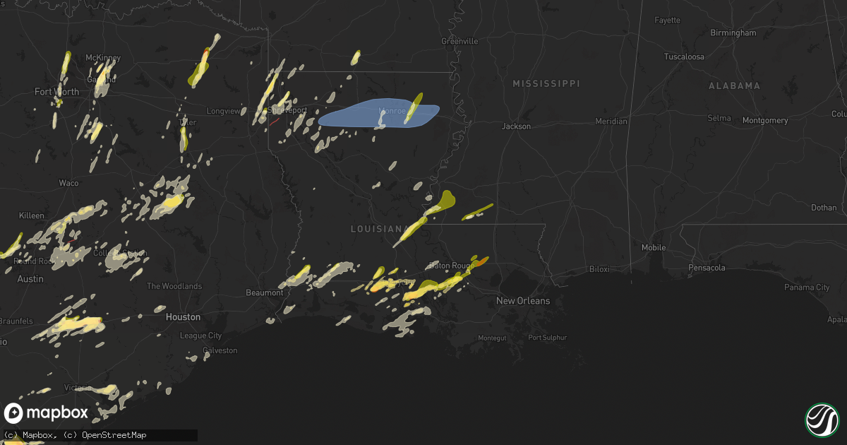
Hail Map in Louisiana on May 6, 2025
Get this storm
May 6 map
$229
one time, instant access
Download today. No call, no setup
Keep the $229
Bought the map and want the full workflow? Apply the entire $229 to a subscription within 7 days. None of it is wasted.
Every map, not just this one
This buys you this map. Subscription and you get every map we run, in the markets you choose from a few cities to whole states to nationwide. Plus real-time alerts the moment a storm fires.
Contact data
Name, contact info, occupancy, even credit band for addresses in the footprint. You go from where it hit to who to call.
Become the source they trust
Unlimited branding weather history reports on demand. You already have the documented answer ready for the property owner, and you are the one who showed up with it.
Property data and RoofTrace estimates
Pull up any address you have got, its value and the exact code rules for that jurisdiction, straight from One Click Code. Then RoofTrace estimates the squares, pitch, and roof value, priced the way you price.
Storm reports in Louisiana
Louisiana
| Date | Description |
|---|---|
| 05/06/20255:39 PM CDT | Quarter size hail reported by public north of livingston... La. |
| 05/06/20255:34 PM CDT | Public reported quarter size hail near walker... La. |
| 05/06/20255:33 PM CDT | Photo received via social media of marble to quarter size hail. |
| 05/06/20255:32 PM CDT | Report of a tree down on top of a house in the tanglewood subdivision. |
| 05/06/20255:31 PM CDT | Report of trees down on walker rd. |
| 05/06/20255:30 PM CDT | Report of power lines down on martin tram rd. |
| 05/06/20255:27 PM CDT | Report of roof blown off house... Trees down at intersection of red cut loop and red cut rd. |
| 05/06/20255:26 PM CDT | Power pole down along north 7th st. |
| 05/06/20255:25 PM CDT | Tree down on pennington rd near union grove ch rd. |
| 05/06/20255:22 PM CDT | Power pole snapped along rainbow dr. |
| 05/06/20255:20 PM CDT | Tree down on a house on ervin cotton rd. |
| 05/06/20255:20 PM CDT | Tree down in the road hwy 828 near willie brantley rd. |
| 05/06/20255:13 PM CDT | Report of a tree down on hwy 552 near henry rd. |
| 05/06/20255:12 PM CDT | Tree down on hwy 15 near arthur mcdaniel rd. |
| 05/06/20255:12 PM CDT | Tree down on downsville rd near hamilton rd. |
| 05/06/20255:10 PM CDT | Damage to home on flat creek rd. |
| 05/06/20254:45 PM CDT | Photo receive of quarter size hail in dequincy. |
| 05/06/20254:45 PM CDT | Social media photo of a tree down on rigmaiden cemetery road. Time estimated by radar. |
| 05/06/20254:43 PM CDT | Report of tree down across hwy 557 near elliot rd. |
| 05/06/20254:34 PM CDT | A local report indicates 1.00 inch wind near 3 ESE Mer Rouge |
| 05/06/20254:28 PM CDT | Tree down across highway 507 near highway 71. |
| 05/06/20254:25 PM CDT | Tree down across highway 480 near the red river/natchitoches parish line. |
| 05/06/20254:22 PM CDT | Tree down across highway 784 near grand bayou. |
| 05/06/20253:54 PM CDT | Trees down across highway 71 near the crossroads community. |
| 05/06/20253:53 PM CDT | Near ping pong ball sized hail fell near the city of livingston. |
| 05/06/20253:45 PM CDT | Social media report of quarter sized hail in elm grove. |
| 05/06/20253:44 PM CDT | Report of a tree down on hall rd. |
| 05/06/20253:33 PM CDT | Trees were snapped along woolworth road south of walnut hill elementary/middle school near the entrance to the caddo parish landfill. A radar indicated tds was depicted |
| 05/06/20253:33 PM CDT | Trees were snapped along woolworth road south of walnut hill elementary/middle school near the entrance to the caddo parish landfi |
| 05/06/20253:30 PM CDT | A comment on a social media post showed quarter sized hail south of walker. |
| 05/06/20253:23 PM CDT | Report of tree down on sr 172 near blueberry trail. |
| 05/06/20253:12 PM CDT | Report of a tree down on la-126 near the natchitoches/winn parish line. |
| 05/06/20252:44 PM CDT | Broadcast media reports quarter sized hail at lexington estates in baton rouge. |
| 05/06/20252:16 PM CDT | Social media report of quarter sized hail in benton. |
| 05/06/20251:55 PM CDT | Social media report of quarter sized hail near northwood high school in blanchard. |
| 05/06/20251:44 PM CDT | Iberville parish office of homeland security and emergency preparedness relayed multiple reports of quarter sized hail in bayou sorrel. |
| 05/06/202512:59 PM CDT | Report from mping: half dollar |
| 05/06/202512:55 PM CDT | Social media report of quarter size hail in loreauville. |
| 05/06/202512:35 PM CDT | Corrects previous hail report from loreauville. Social media report of quarter size hail in loreauville. |
| 05/06/202512:20 PM CDT | Social media report of quarter size hail. |
| 05/06/202511:59 AM CDT | Broadcast media reports hail in west lafayette. |
| 05/06/202511:42 AM CDT | Photo received of ping pong size hail. Time estimated by radar. |
| 05/06/202511:42 AM CDT | Photo received of quarter size hail in loreauville. Time estimated by radar. |
| 05/06/202511:40 AM CDT | Fb photo showing large ping pong to golf ball size hail scattered around the cane run golf course. |
| 05/06/202511:28 AM CDT | Social media photo of quarter size hail at duson. |
| 05/06/202511:13 AM CDT | Photo received of quarter to ping pong ball size hail at crowley. |
| 05/06/202511:09 AM CDT | Social media photo of quarter size hail at branch. |
| 05/06/202511:07 AM CDT | Photos received of golf ball size hail at lyons point. Time estimated by radar. |
| 05/05/202511:30 PM CDT | Mesonet station xptn pontchartrain causeway. |
| 05/05/20258:53 PM CDT | A local report indicates 1.25 inch wind near 2 N Carville |
| 05/05/20258:45 PM CDT | Fb report of large trees blown down near oakdale. |
| 05/05/20258:18 PM CDT | Report of a carport blown down onto a vehicle. Carport destroyed. Time estimated by radar. |
| 05/05/20258:06 PM CDT | Report of tree down in boyce. Time estimated by radar. |
| 05/05/20257:20 PM CDT | Emergency manager reports numerous trees down between sunset and leonville. |
| 05/05/20257:17 PM CDT | Report of tree down in deville. Time estimated from radar. |
| 05/05/20257:14 PM CDT | Emergency manager reports quarter size hail in grand coteau. |
| 05/05/20257:13 PM CDT | Vehicle hit a tree that had fallen onto hwy 112 at turner rd. Time estimated from radar. |
| 05/05/20257:10 PM CDT | A tree was blown down onto power lines on highway 127 south at white sulphur springs road in the rogers community. |
All States Impacted by Hail Map on May 6, 2025
Cities Impacted by Hail Map on May 6, 2025
- Cisco, TX
- Cross Plains, TX
- Brownwood, TX
- Fredericksburg, TX
- Rising Star, TX
- Rocksprings, TX
- Stonewall, TX
- Carbon, TX
- Johnson City, TX
- Round Mountain, TX
- Clifton, TX
- Sonora, TX
- Cleburne, TX
- Rio Vista, TX
- Horseshoe Bay, TX
- Marble Falls, TX
- Llano, TX
- Meridian, TX
- Joshua, TX
- Burleson, TX
- Keene, TX
- Spicewood, TX
- Fort Worth, TX
- Bertram, TX
- Liberty Hill, TX
- Brackettville, TX
- Leander, TX
- Fredonia, TX
- Voca, TX
- Richland Springs, TX
- San Saba, TX
- Haltom City, TX
- Junction, TX
- Colleyville, TX
- Keller, TX
- Roanoke, TX
- Argyle, TX
- Justin, TX
- Flower Mound, TX
- Denton, TX
- Brownsboro, TX
- Boerne, TX
- Comfort, TX
- Crowley, TX
- Italy, TX
- Waxahachie, TX
- Milford, TX
- North Richland Hills, TX
- Southlake, TX
- Hurst, TX
- Jarrell, TX
- Georgetown, TX
- Florence, TX
- Leakey, TX
- Camp Wood, TX
- Lancaster, TX
- Salado, TX
- Hye, TX
- Mount Calm, TX
- Coolidge, TX
- Hunt, TX
- Blooming Grove, TX
- Frost, TX
- Holland, TX
- Cresson, TX
- Granbury, TX
- Dawson, TX
- Hubbard, TX
- Dallas, TX
- Bartlett, TX
- Belton, TX
- Mesquite, TX
- Dublin, TX
- Balch Springs, TX
- Rogers, TX
- Temple, TX
- Garland, TX
- Vanderpool, TX
- Ennis, TX
- Little River Academy, TX
- Purdon, TX
- Sunnyvale, TX
- Wortham, TX
- Rowlett, TX
- Barry, TX
- Corsicana, TX
- Lindale, TX
- Winnsboro, TX
- Chandler, TX
- Richland, TX
- Crowley, LA
- Estherwood, LA
- Gueydan, LA
- Morse, LA
- Sachse, TX
- Wylie, TX
- Richardson, TX
- Plano, TX
- Leesburg, TX
- Pittsburg, TX
- Gilmer, TX
- Scroggins, TX
- Rayne, LA
- Branch, LA
- Church Point, LA
- Burlington, TX
- Grand Chenier, LA
- Creole, LA
- Dripping Springs, TX
- Rockwall, TX
- Allen, TX
- Knippa, TX
- Uvalde, TX
- Rosebud, TX
- Lott, TX
- Egan, LA
- Hawkins, TX
- Princeton, TX
- Kaplan, LA
- Powell, TX
- Crystal City, TX
- Nevada, TX
- Mount Vernon, TX
- Mount Pleasant, TX
- Winfield, TX
- Duson, LA
- Cedar Park, TX
- Mckinney, TX
- Forreston, TX
- Round Rock, TX
- Austin, TX
- New Iberia, LA
- Granger, TX
- Farmersville, TX
- La Pryor, TX
- Batesville, TX
- Saint Martinville, LA
- Lafayette, LA
- Blanco, TX
- Reagan, TX
- Manheim, PA
- Washington, LA
- Plaucheville, LA
- Palmetto, LA
- Bunkie, LA
- Maurice, LA
- Taylor, TX
- Marlin, TX
- Loreauville, LA
- Bremond, TX
- Thorndale, TX
- Buckholts, TX
- Kosse, TX
- Lebanon, PA
- Thrall, TX
- Coupland, TX
- Talco, TX
- Simmesport, LA
- Myerstown, PA
- Marshall, TX
- Rockdale, TX
- Cameron, TX
- Davilla, TX
- Waskom, TX
- Avery, TX
- Annona, TX
- Lettsworth, LA
- Bethel, PA
- Rehrersburg, PA
- Richland, PA
- Bernville, PA
- Womelsdorf, PA
- Monterey, LA
- D Hanis, TX
- Batchelor, LA
- Woodville, MS
- Jeanerette, LA
- Yancey, TX
- Hondo, TX
- Devine, TX
- Karnack, TX
- Vivian, LA
- Mooringsport, LA
- Jacksonville, TX
- Schuylkill Haven, PA
- Rusk, TX
- Auburn, PA
- Pine Grove, PA
- Tyler, TX
- Flint, TX
- Elgin, TX
- Oil City, LA
- Bullard, TX
- Crosby, MS
- Gloster, MS
- Natchez, MS
- Linden, TX
- Jefferson, TX
- Atlanta, TX
- Lexington, TX
- Marquez, TX
- Rodessa, LA
- Bivins, TX
- Ida, LA
- Franklin, TX
- Plaquemine, LA
- Whitehouse, TX
- Milano, TX
- Caldwell, TX
- Grosse Tete, LA
- Hosston, LA
- Castroville, TX
- La Coste, TX
- Doddridge, AR
- Reading, PA
- Larue, TX
- De Berry, TX
- Buffalo, TX
- Jewett, TX
- Roxie, MS
- Oakwood, TX
- Centerville, TX
- Bradley, AR
- Fouke, AR
- Gause, TX
- White Castle, LA
- Shreveport, LA
- Elkhart, TX
- Bryan, TX
- Hearne, TX
- Gilliam, LA
- Normangee, TX
- Leona, TX
- Plain Dealing, LA
- Benton, LA
- Grapeland, TX
- Elm Grove, LA
- Taylor, AR
- Haughton, LA
- Coushatta, LA
- Grand Cane, LA
- Barton, NY
- Nichols, NY
- Owego, NY
- Roswell, NM
- Doyline, LA
- Bossier City, LA
- Saint Gabriel, LA
- Gloster, LA
- Frierson, LA
- Madisonville, TX
- Midway, TX
- Carville, LA
- Heflin, LA
- Sibley, LA
- Crockett, TX
- Alto, TX
- Newark Valley, NY
- Berkshire, NY
- Hall Summit, LA
- Ringgold, LA
- Cushing, TX
- Minden, LA
- Candor, NY
- Sunshine, LA
- Baton Rouge, LA
- Athens, LA
- Somerville, TX
- El Dorado, AR
- Lovelady, TX
- Denham Springs, LA
- Prairieville, LA
- College Station, TX
- Snook, TX
- Pollock, LA
- Homer, LA
- Gibsland, LA
- Ashland, LA
- Saline, LA
- Jonesboro, LA
- Gonzales, TX
- Waelder, TX
- Pen Argyl, PA
- Bangor, PA
- Nazareth, PA
- Keithville, LA
- Harwood, TX
- Iola, TX
- Immokalee, FL
- Castor, LA
- Smithville, TX
- Flatonia, TX
- Jena, LA
- Bienville, LA
- Kennard, TX
- Walker, LA
- Livingston, LA
- Newmanstown, PA
- Lititz, PA
- Schaefferstown, PA
- Fredericksburg, PA
- Jonesville, LA
- West Monroe, LA
- Chatham, LA
- Sikes, LA
- Anderson, TX
- Orange, TX
- West Point, TX
- La Grange, TX
- Muldoon, TX
- Olla, LA
- Bernice, LA
- Summerfield, LA
- Eros, LA
- Giddings, TX
- Rayville, LA
- Cost, TX
- Columbia, LA
- Navasota, TX
- Henderson, NV
- Bedias, TX
- Ferriday, LA
- Friona, TX
- Hereford, TX
- Starks, LA
- Vinton, LA
- Vidalia, LA
- Mangham, LA
- Oak Ridge, LA
- Holden, LA
- Albany, LA
- Springfield, LA
- Dequincy, LA
- Shiner, TX
- Labelle, FL
- Sulphur, LA
- Schulenburg, TX
- Fayetteville, TX
- Round Top, TX
- Moulton, TX
- Red Oak, TX
- Dodson, LA
- Alva, FL
- Maypearl, TX
- Palmer, TX
- Dimmitt, TX
- Centreville, MS
- Liberty, MS
- Clewiston, FL
- Kenansville, FL
- Richards, TX
- Westlake, LA
- Lake Charles, LA
- Moore Haven, FL
- Florien, LA
- Smithdale, MS
- Okeechobee, FL
- Iowa, LA
- Washington, TX
- Kinder, LA
- Glen Spey, NY
- Matamoras, PA
- Millrift, PA
- Milford, PA
- Sparrow Bush, NY
- Weimar, TX
- Ragley, LA
- Columbus, TX
- Laughlin, NV
- Cal Nev Ari, NV
- Elton, LA
- Singer, LA
- Vero Beach, FL
- Jamestown, LA
- Dubberly, LA
- Arcadia, LA
- Quitman, LA
- Simsboro, LA
- Ruston, LA
- Grambling, LA
- Choudrant, LA
- Downsville, LA
- Monroe, LA
- Calhoun, LA
- Collinston, LA
- Farmerville, LA
- Sterlington, LA
- Summit, MS
- Nipton, CA
- Welsh, LA
- Roanoke, LA
- Lake Wales, FL
- Jennings, LA
- Hallettsville, TX
- Searchlight, NV
- Jean, NV
- Merryville, LA
- Woodridge, NY
- Fallsburg, NY
- Hart, TX
- Epps, LA
- Delhi, LA
- Baskin, LA
- Sondheimer, LA
- Tallulah, LA
- Bell City, LA
- Idalou, TX
- Lorida, FL
- Oakland, TX
- Basile, LA
- Iota, LA
- Lorenzo, TX
- Ralls, TX
- Fort Mohave, AZ
- Bullhead City, AZ
- Kress, TX
- Lake Placid, FL
- Venus, FL
- Eunice, LA
- Mohave Valley, AZ
- Plainview, TX
- Abernathy, TX
- Hale Center, TX
- Cuero, TX
- Olton, TX
- Lacassine, LA
- Lake Arthur, LA
- Cameron, LA
- Fort Meade, FL
- Scott, LA
- Crosbyton, TX
- Sunset, LA
- Carencro, LA
- Arnaudville, LA
- Beeville, TX
- Kenedy, TX
- Brookshire, TX
- Sealy, TX
- Bowling Green, FL
- Dickens, TX
- Opelousas, LA
- Breaux Bridge, LA
- Mcadoo, TX
- Yorktown, TX
- Freer, TX
- George West, TX
- Mermentau, LA
- Katy, TX
- Goliad, TX
- Garwood, TX
- Roma, TX
- Cypress, TX
- Houston, TX
- Laredo, TX
- Mirando City, TX
- Spur, TX
- Maringouin, LA
- Bruni, TX
- Rosedale, LA
- Port Allen, LA
- Orange Grove, TX
- Richmond, TX
- Geismar, LA
- Sandia, TX
- Addis, LA
- Brusly, LA
- Gonzales, LA
- San Ygnacio, TX
- Zapata, TX
- Hebbronville, TX
- Victoria, TX
- Mathis, TX
- Abbeville, LA
- Bloomington, TX
- Inez, TX
- Edna, TX
- Sinton, TX
- Odem, TX
- Donaldsonville, LA
- Youngsville, LA
- Lolita, TX
- Needles, CA
- Delcambre, LA
- Erath, LA
- Franklin, LA
- Allentown, PA
- Emmaus, PA
- Center Valley, PA
- Coopersburg, PA
- Macungie, PA
- Zionsville, PA
- Whitehall, PA
- Bethlehem, PA
- Bath, PA
- Coplay, PA
- Northampton, PA
- Catasauqua, PA
- Eagle Pass, TX
- Carrizo Springs, TX
- Encino, TX
- Falfurrias, TX
- Sarita, TX
- Riviera, TX
- San Diego, TX
- Kingsville, TX
- Guerra, TX
- Asherton, TX
- Concepcion, TX
- Realitos, TX
- Cotulla, TX
- Las Vegas, NV
- Premont, TX
- Port Arthur, TX
- Seadrift, TX
- Port O'Connor, TX
- Bay City, TX
- Palacios, TX
- Port Lavaca, TX
- Danbury, TX
- Freeport, TX
- Liverpool, TX
- Galveston, TX
- Hitchcock, TX
- Baldwin, LA


