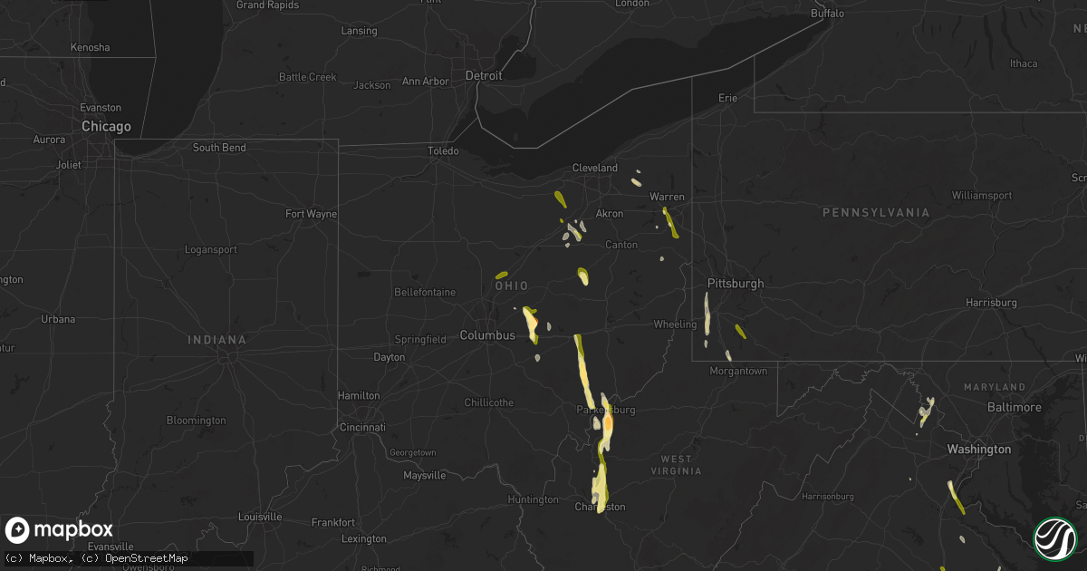
Hail Map in Ohio on May 5, 2025
Get this storm
May 5 map
$229
one time, instant access
Download today. No call, no setup
Keep the $229
Bought the map and want the full workflow? Apply the entire $229 to a subscription within 7 days. None of it is wasted.
Every map, not just this one
This buys you this map. Subscription and you get every map we run, in the markets you choose from a few cities to whole states to nationwide. Plus real-time alerts the moment a storm fires.
Contact data
Name, contact info, occupancy, even credit band for addresses in the footprint. You go from where it hit to who to call.
Become the source they trust
Unlimited branding weather history reports on demand. You already have the documented answer ready for the property owner, and you are the one who showed up with it.
Property data and RoofTrace estimates
Pull up any address you have got, its value and the exact code rules for that jurisdiction, straight from One Click Code. Then RoofTrace estimates the squares, pitch, and roof value, priced the way you price.
Storm reports in Ohio
Ohio
| Date | Description |
|---|---|
| 05/05/20256:38 PM CDT | Tree down near abbeyville road and sr 18/57. |
| 05/05/20256:32 PM CDT | Minor flooding was also reported at an rv park. |
| 05/05/20256:29 PM CDT | Several trees and limbs down. |
| 05/05/20256:16 PM CDT | Wayne county 911 dispatch received a report of a tree down at sterling road and parmenter road. |
| 05/05/20256:15 PM CDT | A local report indicates 1.25 inch wind near 4 NW Smithville |
| 05/05/20256:03 PM CDT | Wayne county 911 dispatch received a report of a tree down at kansas road and church road. |
| 05/05/20255:36 PM CDT | Tree down on power lines... Time estimated via radar. |
| 05/05/20255:33 PM CDT | Spotter reported quarter sized hail in berlin. |
| 05/05/20255:17 PM CDT | A local report indicates 1.00 inch wind near 8 ESE Millersburg |
| 05/05/20254:59 PM CDT | Knox county 911 dispatch received reports of numerous trees down in the city of mount vernon. |
| 05/05/20254:34 PM CDT | Estimated time based on radar data. |
| 05/05/20254:17 PM CDT | A local report indicates 1.00 inch wind near 3 NE Pleasant Grove |
| 05/05/20254:17 PM CDT | Tree down on ridge road. |
| 05/05/20254:11 PM CDT | A local report indicates 1.25 inch wind near Canfield |
| 05/05/20254:07 PM CDT | Several reports received in newark. |
| 05/05/20254:03 PM CDT | Report from mping: golf ball |
| 05/05/20254:03 PM CDT | Tree down on culter lake road. |
| 05/05/20254:00 PM CDT | A local report indicates 1.00 inch wind near 2 SE Philo |
| 05/05/20253:32 PM CDT | Report from mping: quarter |
| 05/05/20253:30 PM CDT | Lots of golf ball size hail reported. Photo provided from mcconnesville. |
| 05/05/20253:18 PM CDT | A local report indicates 1.00 inch wind near 3 SSE Mount Gilead |
| 05/05/20252:36 PM CDT | Report from mping: quarter |
| 05/05/20251:43 PM CDT | A local report indicates 1.00 inch wind near 3 NW Hiram |
| 05/04/20257:11 PM CDT | Several tree limbs down. Time estimated via radar. |
| 05/04/20257:05 PM CDT | Lasted 5 minutes. |
All States Impacted by Hail Map on May 5, 2025
Cities Impacted by Hail Map on May 5, 2025
- Spur, TX
- Crosbyton, TX
- Jayton, TX
- Charlotte, TX
- Aspermont, TX
- Campbellton, TX
- Jourdanton, TX
- Pleasanton, TX
- Clyde, TX
- Floresville, TX
- Baird, TX
- Ballinger, TX
- Winters, TX
- Cross Plains, TX
- Hamlin, TX
- Talpa, TX
- Cisco, TX
- Mechanicsville, VA
- Moran, TX
- Breckenridge, TX
- Albany, TX
- Bluff Dale, TX
- Bastrop, TX
- Paige, TX
- Durham, NC
- McDade, TX
- Apex, NC
- Morrisville, NC
- Tolar, TX
- Ashland, VA
- Ranger, TX
- Creedmoor, NC
- Leander, TX
- Georgetown, TX
- Liberty Hill, TX
- Eastland, TX
- Farmington, NM
- Grandview, TX
- Covington, TX
- Clinton, NC
- Rio Vista, TX
- Cleburne, TX
- Jarrell, TX
- Florence, TX
- Cubero, NM
- Turkey, NC
- Itasca, TX
- Mount Olive, NC
- Seven Springs, NC
- Elgin, TX
- Manor, TX
- Charleston, WV
- Elkview, WV
- Dunbar, WV
- South Charleston, WV
- Italy, TX
- Goldsboro, NC
- La Grange, NC
- Waxahachie, TX
- Forreston, TX
- Milford, TX
- Raleigh, NC
- Fuquay Varina, NC
- Wellington, FL
- Willow Spring, NC
- Miami, FL
- West Palm Beach, FL
- Cary, NC
- Lincoln, TX
- Giddings, TX
- Ennis, TX
- Fellsmere, FL
- Pikeville, NC
- Snow Hill, NC
- Lexington, TX
- Garner, NC
- Fremont, NC
- Lake Worth, FL
- Sebastian, FL
- Kenna, WV
- Angier, NC
- Boynton Beach, FL
- Knightdale, NC
- Ripley, WV
- Stantonsburg, NC
- Hiram, OH
- Garrettsville, OH
- Advent, WV
- Gandeeville, WV
- Gay, WV
- Wilson, NC
- Alton, VA
- Chagrin Falls, OH
- Mantua, OH
- Macclesfield, NC
- Pinetops, NC
- Vero Beach, FL
- Dime Box, TX
- Caldwell, TX
- Ledbetter, TX
- Wendell, NC
- Carmine, TX
- Burton, TX
- Le Roy, WV
- Sandyville, WV
- Rocky Mount, NC
- Elm City, NC
- Wallace, NC
- Willard, NC
- Zebulon, NC
- Ayden, NC
- Grifton, NC
- Bethel, NC
- Delray Beach, FL
- Winterville, NC
- Greenville, NC
- Roswell, NM
- Brenham, TX
- Given, WV
- Tarboro, NC
- Palestine, WV
- Elizabeth, WV
- Nashville, NC
- Wake Forest, NC
- Grimesland, NC
- Cutler, OH
- Little Hocking, OH
- Vincent, OH
- Yeso, NM
- Beulaville, NC
- Oak City, NC
- Robersonville, NC
- Coolville, OH
- Rockport, WV
- Ravenswood, WV
- Chinquapin, NC
- Spring Hope, NC
- Middlesex, NC
- Battleboro, NC
- Belleville, WV
- Washington, NC
- Hamilton, NC
- Washington, WV
- Castalia, NC
- Whitakers, NC
- Mineral Wells, WV
- Chocowinity, NC
- Boca Raton, FL
- Fort Lauderdale, FL
- Stockport, OH
- Davisville, WV
- Parkersburg, WV
- Vienna, WV
- Belpre, OH
- Emporia, VA
- Skippers, VA
- Drewryville, VA
- Amesville, OH
- Richlands, NC
- Fort Sumner, NM
- Fort Pierce, FL
- Four Oaks, NC
- Palacios, TX
- Newton Grove, NC
- Marietta, OH
- Malta, OH
- Lolita, TX
- Fleming, OH
- Williamston, NC
- Clayton, NC
- Junction City, OH
- Somerset, OH
- Rushville, OH
- Bremen, OH
- Mcconnelsville, OH
- Mount Gilead, OH
- Cardington, OH
- Thornville, OH
- Hebron, OH
- Jacksontown, OH
- Heath, OH
- Elida, NM
- Blue Rock, OH
- Elmaton, TX
- Bay City, TX
- Chesterfield, VA
- Richmond, VA
- Windsor, NC
- Jarratt, VA
- Jamesville, NC
- Washington, TX
- Loxahatchee, FL
- Navasota, TX
- Van Vleck, TX
- Sweeny, TX
- Newark, OH
- Stony Creek, VA
- Yale, VA
- Buckeye Lake, OH
- Mims, FL
- Oak Hill, FL
- Cuero, TX
- Chandlersville, OH
- Duncan Falls, OH
- Philo, OH
- Zanesville, OH
- West Columbia, TX
- Damon, TX
- Granville, OH
- Quinn, SD
- Clewiston, FL
- Yoakum, TX
- Charles City, VA
- Port Saint Lucie, FL
- Taiban, NM
- Chappell Hill, TX
- Johnstown, OH
- Utica, OH
- Youngstown, OH
- North Jackson, OH
- Warren, OH
- Canfield, OH
- Columbiana, OH
- Salem, OH
- Leetonia, OH
- Plymouth, NC
- Gause, TX
- Providence Forge, VA
- Jackson, NC
- Cameron, TX
- Sandston, VA
- Saint Louisville, OH
- Rosharon, TX
- Hearne, TX
- Bryan, TX
- Tatum, NM
- Lovington, NM
- Waverly, VA
- Wasta, SD
- Croton, OH
- Saint Cloud, FL
- Needville, TX
- Milano, TX
- Goldsmith, TX
- Odessa, TX
- King George, VA
- Jensen Beach, FL
- Missouri City, TX
- Fresno, TX
- Manvel, TX
- Pearland, TX
- Jal, NM
- Quinton, VA
- New Kent, VA
- Lovettsville, VA
- Shiner, TX
- Faison, NC
- Hempstead, TX
- Milford, VA
- Newtown, VA
- Purcellville, VA
- Hamilton, VA
- Waterford, VA
- Millersburg, OH
- Fresno, OH
- New Underwood, SD
- Owanka, SD
- Lanexa, VA
- Bowling Green, VA
- Port Royal, VA
- Houston, TX
- Baltic, OH
- King William, VA
- West Point, VA
- Little Plymouth, VA
- Hobgood, NC
- Howes, SD
- Gardendale, TX
- Richards, TX
- Montgomery, TX
- Waller, TX
- Hockley, TX
- Sugarcreek, OH
- Faith, SD
- Union Center, SD
- Lake Placid, FL
- Stafford, VA
- Quantico, VA
- King And Queen Court House, VA
- Triangle, VA
- Kelford, NC
- Lewiston Woodville, NC
- Pink Hill, NC
- Deep Run, NC
- Willis, TX
- Huntsville, TX
- New Waverly, TX
- Pasadena, TX
- Deer Park, TX
- Prairie View, TX
- Andrews, TX
- Center Cross, VA
- Laneview, VA
- Knoxville, MD
- Kenansville, FL
- Okeechobee, FL
- Fayetteville, TX
- Round Top, TX
- Roxobel, NC
- Aulander, NC
- Channelview, TX
- Stanton, TX
- Midland, TX
- Crosby, TX
- Highlands, TX
- Baytown, TX
- Magnolia, TX
- Kinston, NC
- Dumfries, VA
- La Porte, TX
- La Grange, TX
- Galena Park, TX
- Palm Bay, FL
- Tomball, TX
- Dayton, TX
- Brunswick, MD
- Warrenton, VA
- Pinehurst, TX
- Somerville, TX
- Grant, FL
- Jeffersonton, VA
- Jefferson, MD
- Dupree, SD
- Cleveland, TX
- Hobbs, NM
- Montvale, VA
- Thaxton, VA
- Middleburg, VA
- Coldspring, TX
- Shepherd, TX
- Lucama, NC
- Seminole, TX
- Creston, OH
- Seville, OH
- Isabel, SD
- Burbank, OH
- West Salem, OH
- Wooster, OH
- Livingston, TX
- Goodrich, TX
- Hurdsfield, ND
- Rittman, OH
- Sterling, OH
- Graysville, PA
- Holbrook, PA
- Waynesburg, PA
- Smithville, OH
- Dilliner, PA
- Mount Morris, PA
- Prosperity, PA
- Litchfield, OH
- Goodrich, ND
- McIntosh, SD
- West Finley, PA
- Sycamore, PA
- Meadow, SD
- McLaughlin, SD
- Timber Lake, SD
- Artesia, NM
- Claysville, PA
- Washington, PA
- Fort Yates, ND
- Eunice, NM
- Kermit, TX
- Big Spring, TX
- Avella, PA
- Carlsbad, NM
- Merry Hill, NC
- Hickory, PA
- Salineville, OH
- Summitville, OH
- McDonald, PA
- Kensington, OH
- Edenton, NC
- Selfridge, ND
- Regan, ND
- Tuttle, ND
- Bismarck, ND
- Bulger, PA
- Burgettstown, PA
- Edgewood, NM
- Hanoverton, OH
- Imperial, PA
- Moriarty, NM
- Clinton, PA
- Aliquippa, PA
- College Station, TX
- Mandan, ND
- Comstock, TX
- Ozona, TX
- Beloit, OH
- Maljamar, NM
- Sonora, TX
- Burton, OH
- Pecos, TX
- Cedar Creek, TX
- Loving, NM
- Spring, TX
- Salt Flat, TX
- Mentone, TX
- Wink, TX
- Fort Stockton, TX
- Balmorhea, TX
- Mcdonald, NM
- Crane, TX
- Dryden, TX
- Monahans, TX
- Iraan, TX
- Sheffield, TX
- Barstow, TX
- Grandfalls, TX
- Eldorado, TX
- McCamey, TX
- Midkiff, TX
- Christoval, TX
- San Angelo, TX
- Vancourt, TX
- Big Lake, TX
- Mertzon, TX
- Eola, TX
- Paint Rock, TX
- Wall, TX
- Garden City, TX
- Mereta, TX
- Rowena, TX
- Goodfellow Afb, TX
- Miles, TX
- Sterling City, TX
- Novice, TX
- Coleman, TX
- Ovalo, TX
- Lawn, TX
- Goldsboro, TX
- Carlsbad, TX
- Robert Lee, TX
- Norton, TX
- Bronte, TX
- Graham, TX
- Medina, TX
- Woodson, TX
- Kerrville, TX
- Newcastle, TX
- Del Rio, TX
- Valera, TX
- Henrico, VA
- South Bend, TX
- Leesburg, VA
- Paeonian Springs, VA
- Burkett, TX
- Menard, TX
- Eden, TX
- Bonham, TX
- Ravenna, TX
- Ivanhoe, TX
- Fredericksburg, TX
- Brownwood, TX
- Rising Star, TX
- Loving, TX
- Olney, TX
- Comfort, TX
- Capron, VA
- Carson, VA
- Apopka, FL
- Adah, PA
- New Salem, PA
- Cardale, PA
- Republic, PA
- East Millsboro, PA
- Brownsville, PA
- Merrittstown, PA
- Hiller, PA
- Denbo, PA
- Daisytown, PA
- Fredericktown, PA
- Homerville, OH
- Grafton, OH
- Lagrange, OH
- Wellington, OH
- Oberlin, OH


