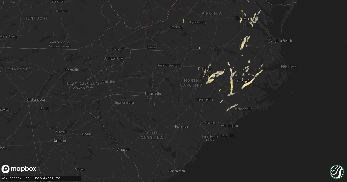
Hail Map in North Carolina on May 5, 2025
Get this storm
May 5 map
$229
one time, instant access
Download today. No call, no setup
Keep the $229
Bought the map and want the full workflow? Apply the entire $229 to a subscription within 7 days. None of it is wasted.
Every map, not just this one
This buys you this map. Subscription and you get every map we run, in the markets you choose from a few cities to whole states to nationwide. Plus real-time alerts the moment a storm fires.
Contact data
Name, contact info, occupancy, even credit band for addresses in the footprint. You go from where it hit to who to call.
Become the source they trust
Unlimited branding weather history reports on demand. You already have the documented answer ready for the property owner, and you are the one who showed up with it.
Property data and RoofTrace estimates
Pull up any address you have got, its value and the exact code rules for that jurisdiction, straight from One Click Code. Then RoofTrace estimates the squares, pitch, and roof value, priced the way you price.
Storm reports in North Carolina
North Carolina
| Date | Description |
|---|---|
| 05/05/20254:11 PM CDT | Delayed report. Drone video from spotter shows tornado on the ground southwest of jamesville. There were also multiple reports and videos submitted showing funnel cloud |
| 05/05/20254:05 PM CDT | Corrected... Local broadcast reported a large tree down on monticello drive. This tree fell on a home. |
| 05/05/20254:05 PM CDT | Local broadcast reported a large tree down on monticello drive. |
| 05/05/20253:06 PM CDT | Hail lasted 10 to 12 minutes. The ground is covered. |
| 05/05/20252:56 PM CDT | Picture submitted via facebook. The hail stone was shown next to a quarter... And based on the picture... It appears to be the size of a golf ball. Time estimated based |
| 05/05/20252:52 PM CDT | Report via facebook. Time estimated from radar. |
| 05/05/20252:52 PM CDT | 30 foot metal flag pole snapped in half. Report via facebook. Time estimated via radar. |
| 05/05/20252:38 PM CDT | Multiple reports of quarter... Or slightly larger... Size hail stones from chicod to grimesland. Report via witn. |
| 05/05/20252:27 PM CDT | Quarter size hail reported near highway 43 southeast of winterville. |
| 05/05/20252:21 PM CDT | Report from mping: quarter |
| 05/05/20252:19 PM CDT | Brief quarter sized hail reported... Mostly pea to half inch sized. |
| 05/05/20251:53 PM CDT | Quarter sized hail occurred on i-540 between capital blvd and us hwy 64 exits. |
| 05/05/20251:40 PM CDT | Along i-540 between capital and us-64 exits. |
| 05/05/20251:26 PM CDT | Tree down along herman lane road. |
| 05/05/20251:24 PM CDT | Report from mping: quarter |
| 05/05/20251:20 PM CDT | Cocorahs observer reported large hail which caused damage to siding of a residence along duckridge drive. Hail size was estimated based on picture from social media. |
| 05/05/20251:17 PM CDT | Report from mping: quarter |
| 05/05/20251:12 PM CDT | Near us 401 and i-40. |
| 05/05/202512:15 PM CDT | Trees down and power outages reported on the southeast side of oxford. Radar estimated time. |
| 05/04/20258:01 PM CDT | A large tree branch knocked down powerlines along rocky hock rd. |
| 05/04/20257:32 PM CDT | Several trees and power lines downed. Power outage. |
| 05/04/20257:30 PM CDT | Several trees downed along with power lines. Numerous 3 inch limbs downed along gilden road. |
All States Impacted by Hail Map on May 5, 2025
Cities Impacted by Hail Map on May 5, 2025
- Spur, TX
- Crosbyton, TX
- Jayton, TX
- Charlotte, TX
- Aspermont, TX
- Campbellton, TX
- Jourdanton, TX
- Pleasanton, TX
- Clyde, TX
- Floresville, TX
- Baird, TX
- Ballinger, TX
- Winters, TX
- Cross Plains, TX
- Hamlin, TX
- Talpa, TX
- Cisco, TX
- Mechanicsville, VA
- Moran, TX
- Breckenridge, TX
- Albany, TX
- Bluff Dale, TX
- Bastrop, TX
- Paige, TX
- Durham, NC
- McDade, TX
- Apex, NC
- Morrisville, NC
- Tolar, TX
- Ashland, VA
- Ranger, TX
- Creedmoor, NC
- Leander, TX
- Georgetown, TX
- Liberty Hill, TX
- Eastland, TX
- Farmington, NM
- Grandview, TX
- Covington, TX
- Clinton, NC
- Rio Vista, TX
- Cleburne, TX
- Jarrell, TX
- Florence, TX
- Cubero, NM
- Turkey, NC
- Itasca, TX
- Mount Olive, NC
- Seven Springs, NC
- Elgin, TX
- Manor, TX
- Charleston, WV
- Elkview, WV
- Dunbar, WV
- South Charleston, WV
- Italy, TX
- Goldsboro, NC
- La Grange, NC
- Waxahachie, TX
- Forreston, TX
- Milford, TX
- Raleigh, NC
- Fuquay Varina, NC
- Wellington, FL
- Willow Spring, NC
- Miami, FL
- West Palm Beach, FL
- Cary, NC
- Lincoln, TX
- Giddings, TX
- Ennis, TX
- Fellsmere, FL
- Pikeville, NC
- Snow Hill, NC
- Lexington, TX
- Garner, NC
- Fremont, NC
- Lake Worth, FL
- Sebastian, FL
- Kenna, WV
- Angier, NC
- Boynton Beach, FL
- Knightdale, NC
- Ripley, WV
- Stantonsburg, NC
- Hiram, OH
- Garrettsville, OH
- Advent, WV
- Gandeeville, WV
- Gay, WV
- Wilson, NC
- Alton, VA
- Chagrin Falls, OH
- Mantua, OH
- Macclesfield, NC
- Pinetops, NC
- Vero Beach, FL
- Dime Box, TX
- Caldwell, TX
- Ledbetter, TX
- Wendell, NC
- Carmine, TX
- Burton, TX
- Le Roy, WV
- Sandyville, WV
- Rocky Mount, NC
- Elm City, NC
- Wallace, NC
- Willard, NC
- Zebulon, NC
- Ayden, NC
- Grifton, NC
- Bethel, NC
- Delray Beach, FL
- Winterville, NC
- Greenville, NC
- Roswell, NM
- Brenham, TX
- Given, WV
- Tarboro, NC
- Palestine, WV
- Elizabeth, WV
- Nashville, NC
- Wake Forest, NC
- Grimesland, NC
- Cutler, OH
- Little Hocking, OH
- Vincent, OH
- Yeso, NM
- Beulaville, NC
- Oak City, NC
- Robersonville, NC
- Coolville, OH
- Rockport, WV
- Ravenswood, WV
- Chinquapin, NC
- Spring Hope, NC
- Middlesex, NC
- Battleboro, NC
- Belleville, WV
- Washington, NC
- Hamilton, NC
- Washington, WV
- Castalia, NC
- Whitakers, NC
- Mineral Wells, WV
- Chocowinity, NC
- Boca Raton, FL
- Fort Lauderdale, FL
- Stockport, OH
- Davisville, WV
- Parkersburg, WV
- Vienna, WV
- Belpre, OH
- Emporia, VA
- Skippers, VA
- Drewryville, VA
- Amesville, OH
- Richlands, NC
- Fort Sumner, NM
- Fort Pierce, FL
- Four Oaks, NC
- Palacios, TX
- Newton Grove, NC
- Marietta, OH
- Malta, OH
- Lolita, TX
- Fleming, OH
- Williamston, NC
- Clayton, NC
- Junction City, OH
- Somerset, OH
- Rushville, OH
- Bremen, OH
- Mcconnelsville, OH
- Mount Gilead, OH
- Cardington, OH
- Thornville, OH
- Hebron, OH
- Jacksontown, OH
- Heath, OH
- Elida, NM
- Blue Rock, OH
- Elmaton, TX
- Bay City, TX
- Chesterfield, VA
- Richmond, VA
- Windsor, NC
- Jarratt, VA
- Jamesville, NC
- Washington, TX
- Loxahatchee, FL
- Navasota, TX
- Van Vleck, TX
- Sweeny, TX
- Newark, OH
- Stony Creek, VA
- Yale, VA
- Buckeye Lake, OH
- Mims, FL
- Oak Hill, FL
- Cuero, TX
- Chandlersville, OH
- Duncan Falls, OH
- Philo, OH
- Zanesville, OH
- West Columbia, TX
- Damon, TX
- Granville, OH
- Quinn, SD
- Clewiston, FL
- Yoakum, TX
- Charles City, VA
- Port Saint Lucie, FL
- Taiban, NM
- Chappell Hill, TX
- Johnstown, OH
- Utica, OH
- Youngstown, OH
- North Jackson, OH
- Warren, OH
- Canfield, OH
- Columbiana, OH
- Salem, OH
- Leetonia, OH
- Plymouth, NC
- Gause, TX
- Providence Forge, VA
- Jackson, NC
- Cameron, TX
- Sandston, VA
- Saint Louisville, OH
- Rosharon, TX
- Hearne, TX
- Bryan, TX
- Tatum, NM
- Lovington, NM
- Waverly, VA
- Wasta, SD
- Croton, OH
- Saint Cloud, FL
- Needville, TX
- Milano, TX
- Goldsmith, TX
- Odessa, TX
- King George, VA
- Jensen Beach, FL
- Missouri City, TX
- Fresno, TX
- Manvel, TX
- Pearland, TX
- Jal, NM
- Quinton, VA
- New Kent, VA
- Lovettsville, VA
- Shiner, TX
- Faison, NC
- Hempstead, TX
- Milford, VA
- Newtown, VA
- Purcellville, VA
- Hamilton, VA
- Waterford, VA
- Millersburg, OH
- Fresno, OH
- New Underwood, SD
- Owanka, SD
- Lanexa, VA
- Bowling Green, VA
- Port Royal, VA
- Houston, TX
- Baltic, OH
- King William, VA
- West Point, VA
- Little Plymouth, VA
- Hobgood, NC
- Howes, SD
- Gardendale, TX
- Richards, TX
- Montgomery, TX
- Waller, TX
- Hockley, TX
- Sugarcreek, OH
- Faith, SD
- Union Center, SD
- Lake Placid, FL
- Stafford, VA
- Quantico, VA
- King And Queen Court House, VA
- Triangle, VA
- Kelford, NC
- Lewiston Woodville, NC
- Pink Hill, NC
- Deep Run, NC
- Willis, TX
- Huntsville, TX
- New Waverly, TX
- Pasadena, TX
- Deer Park, TX
- Prairie View, TX
- Andrews, TX
- Center Cross, VA
- Laneview, VA
- Knoxville, MD
- Kenansville, FL
- Okeechobee, FL
- Fayetteville, TX
- Round Top, TX
- Roxobel, NC
- Aulander, NC
- Channelview, TX
- Stanton, TX
- Midland, TX
- Crosby, TX
- Highlands, TX
- Baytown, TX
- Magnolia, TX
- Kinston, NC
- Dumfries, VA
- La Porte, TX
- La Grange, TX
- Galena Park, TX
- Palm Bay, FL
- Tomball, TX
- Dayton, TX
- Brunswick, MD
- Warrenton, VA
- Pinehurst, TX
- Somerville, TX
- Grant, FL
- Jeffersonton, VA
- Jefferson, MD
- Dupree, SD
- Cleveland, TX
- Hobbs, NM
- Montvale, VA
- Thaxton, VA
- Middleburg, VA
- Coldspring, TX
- Shepherd, TX
- Lucama, NC
- Seminole, TX
- Creston, OH
- Seville, OH
- Isabel, SD
- Burbank, OH
- West Salem, OH
- Wooster, OH
- Livingston, TX
- Goodrich, TX
- Hurdsfield, ND
- Rittman, OH
- Sterling, OH
- Graysville, PA
- Holbrook, PA
- Waynesburg, PA
- Smithville, OH
- Dilliner, PA
- Mount Morris, PA
- Prosperity, PA
- Litchfield, OH
- Goodrich, ND
- McIntosh, SD
- West Finley, PA
- Sycamore, PA
- Meadow, SD
- McLaughlin, SD
- Timber Lake, SD
- Artesia, NM
- Claysville, PA
- Washington, PA
- Fort Yates, ND
- Eunice, NM
- Kermit, TX
- Big Spring, TX
- Avella, PA
- Carlsbad, NM
- Merry Hill, NC
- Hickory, PA
- Salineville, OH
- Summitville, OH
- McDonald, PA
- Kensington, OH
- Edenton, NC
- Selfridge, ND
- Regan, ND
- Tuttle, ND
- Bismarck, ND
- Bulger, PA
- Burgettstown, PA
- Edgewood, NM
- Hanoverton, OH
- Imperial, PA
- Moriarty, NM
- Clinton, PA
- Aliquippa, PA
- College Station, TX
- Mandan, ND
- Comstock, TX
- Ozona, TX
- Beloit, OH
- Maljamar, NM
- Sonora, TX
- Burton, OH
- Pecos, TX
- Cedar Creek, TX
- Loving, NM
- Spring, TX
- Salt Flat, TX
- Mentone, TX
- Wink, TX
- Fort Stockton, TX
- Balmorhea, TX
- Mcdonald, NM
- Crane, TX
- Dryden, TX
- Monahans, TX
- Iraan, TX
- Sheffield, TX
- Barstow, TX
- Grandfalls, TX
- Eldorado, TX
- McCamey, TX
- Midkiff, TX
- Christoval, TX
- San Angelo, TX
- Vancourt, TX
- Big Lake, TX
- Mertzon, TX
- Eola, TX
- Paint Rock, TX
- Wall, TX
- Garden City, TX
- Mereta, TX
- Rowena, TX
- Goodfellow Afb, TX
- Miles, TX
- Sterling City, TX
- Novice, TX
- Coleman, TX
- Ovalo, TX
- Lawn, TX
- Goldsboro, TX
- Carlsbad, TX
- Robert Lee, TX
- Norton, TX
- Bronte, TX
- Graham, TX
- Medina, TX
- Woodson, TX
- Kerrville, TX
- Newcastle, TX
- Del Rio, TX
- Valera, TX
- Henrico, VA
- South Bend, TX
- Leesburg, VA
- Paeonian Springs, VA
- Burkett, TX
- Menard, TX
- Eden, TX
- Bonham, TX
- Ravenna, TX
- Ivanhoe, TX
- Fredericksburg, TX
- Brownwood, TX
- Rising Star, TX
- Loving, TX
- Olney, TX
- Comfort, TX
- Capron, VA
- Carson, VA
- Apopka, FL
- Adah, PA
- New Salem, PA
- Cardale, PA
- Republic, PA
- East Millsboro, PA
- Brownsville, PA
- Merrittstown, PA
- Hiller, PA
- Denbo, PA
- Daisytown, PA
- Fredericktown, PA
- Homerville, OH
- Grafton, OH
- Lagrange, OH
- Wellington, OH
- Oberlin, OH


