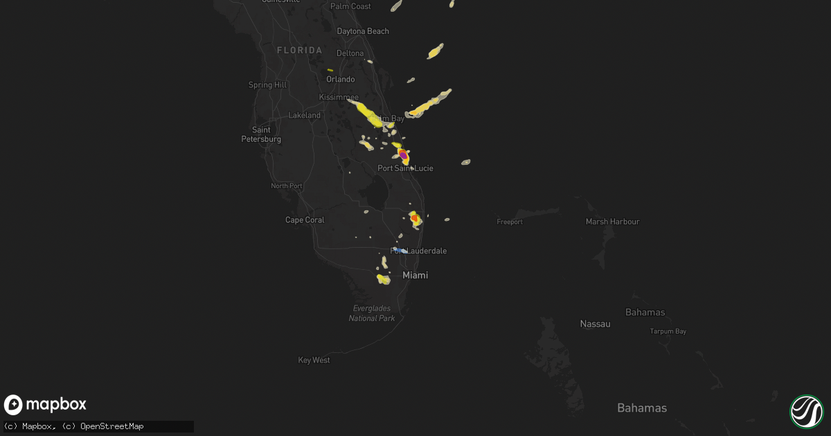
Hail Map on May 5, 2025
Get this storm
May 5 map
$229
one time, instant access
Download today. No call, no setup
Keep the $229
Bought the map and want the full workflow? Apply the entire $229 to a subscription within 7 days. None of it is wasted.
Every map, not just this one
This buys you this map. Subscription and you get every map we run, in the markets you choose from a few cities to whole states to nationwide. Plus real-time alerts the moment a storm fires.
Contact data
Name, contact info, occupancy, even credit band for addresses in the footprint. You go from where it hit to who to call.
Become the source they trust
Unlimited branding weather history reports on demand. You already have the documented answer ready for the property owner, and you are the one who showed up with it.
Property data and RoofTrace estimates
Pull up any address you have got, its value and the exact code rules for that jurisdiction, straight from One Click Code. Then RoofTrace estimates the squares, pitch, and roof value, priced the way you price.
States Impacted by Hail Map on May 5, 2025
Storm reports
North Carolina
| Date | Description |
|---|---|
| 05/05/20254:11 PM CDT | Delayed report. Drone video from spotter shows tornado on the ground southwest of jamesville. There were also multiple reports and videos submitted showing funnel cloud |
| 05/05/20254:05 PM CDT | Local broadcast reported a large tree down on monticello drive. |
| 05/05/20254:05 PM CDT | Corrected... Local broadcast reported a large tree down on monticello drive. This tree fell on a home. |
| 05/05/20253:06 PM CDT | Hail lasted 10 to 12 minutes. The ground is covered. |
| 05/05/20252:56 PM CDT | Picture submitted via facebook. The hail stone was shown next to a quarter... And based on the picture... It appears to be the size of a golf ball. Time estimated based |
| 05/05/20252:52 PM CDT | Report via facebook. Time estimated from radar. |
| 05/05/20252:52 PM CDT | 30 foot metal flag pole snapped in half. Report via facebook. Time estimated via radar. |
| 05/05/20252:38 PM CDT | Multiple reports of quarter... Or slightly larger... Size hail stones from chicod to grimesland. Report via witn. |
| 05/05/20252:27 PM CDT | Quarter size hail reported near highway 43 southeast of winterville. |
| 05/05/20252:21 PM CDT | Report from mping: quarter |
| 05/05/20252:19 PM CDT | Brief quarter sized hail reported... Mostly pea to half inch sized. |
| 05/05/20251:53 PM CDT | Quarter sized hail occurred on i-540 between capital blvd and us hwy 64 exits. |
| 05/05/20251:40 PM CDT | Along i-540 between capital and us-64 exits. |
| 05/05/20251:26 PM CDT | Tree down along herman lane road. |
| 05/05/20251:24 PM CDT | Report from mping: quarter |
| 05/05/20251:20 PM CDT | Cocorahs observer reported large hail which caused damage to siding of a residence along duckridge drive. Hail size was estimated based on picture from social media. |
| 05/05/20251:17 PM CDT | Report from mping: quarter |
| 05/05/20251:12 PM CDT | Near us 401 and i-40. |
| 05/05/202512:15 PM CDT | Trees down and power outages reported on the southeast side of oxford. Radar estimated time. |
| 05/04/20258:01 PM CDT | A large tree branch knocked down powerlines along rocky hock rd. |
| 05/04/20257:32 PM CDT | Several trees and power lines downed. Power outage. |
| 05/04/20257:30 PM CDT | Several trees downed along with power lines. Numerous 3 inch limbs downed along gilden road. |
Pennsylvania
| Date | Description |
|---|---|
| 05/05/20253:37 PM CDT | Picture showing a few quarter size hailstones mixed with a bunch of smaller hail. |
New Mexico
| Date | Description |
|---|---|
| 05/05/20254:57 PM CDT | Dime to quarter size hail reported by storm chaser. |
| 05/04/202511:24 PM CDT | Report from mping: quarter |
| 05/04/20258:20 PM CDT | Multiple reports of golf to tennis ball size hail. Time was estimated by radar. |
| 05/04/20258:14 PM CDT | Public reports of quarter size hail. Time was estimated by radar. |
| 05/04/20257:18 PM CDT | [landspout] short-lived |
Virginia
| Date | Description |
|---|---|
| 05/05/20256:54 PM CDT | Multiple calls for trees down in western loudoun county from middleburg to lovettsville. |
| 05/05/20256:36 PM CDT | Multiple trees down on zulla road. |
| 05/05/20256:02 PM CDT | A large tree was knocked down along menokin rd. |
| 05/05/20255:57 PM CDT | Multiple trees down on south side of dale city near cardinal drive. |
| 05/05/20255:47 PM CDT | A local report indicates 1.00 inch wind near 2 WSW Triangle |
| 05/05/20255:43 PM CDT | Several trees down on joplin road. |
| 05/05/20255:43 PM CDT | A large tree was blown down across highway 35. |
| 05/05/20255:33 PM CDT | Tree down on mountain view road. |
| 05/05/20255:29 PM CDT | Two trees down on potomac run road |
| 05/05/20255:20 PM CDT | Trees down in the town of king and queen courthouse. |
| 05/05/20255:17 PM CDT | Trees reported down across eastern new kent. |
| 05/05/20255:15 PM CDT | Trees were knocked down along route 301 southbound near ft walker. |
| 05/05/20255:04 PM CDT | A massive tree knocked along snowden rd. |
| 05/05/20254:59 PM CDT | Trees reported down across new kent county. |
| 05/05/20254:56 PM CDT | Six calls for trees down throughout the county. |
| 05/05/20254:50 PM CDT | Tree down blocking west bound lanes. Time estimated. |
| 05/05/20254:48 PM CDT | A local report indicates 1.00 inch wind near 2 NE Purcellville |
| 05/05/20254:45 PM CDT | A massive tree was knocked down at the intersection of loving union rd and hair rd. |
| 05/05/20254:40 PM CDT | A massive tree was knocked down along hair rd. |
| 05/05/20254:25 PM CDT | A local report indicates 1.00 inch wind near 1 NNW Mountcastle |
| 05/05/20254:05 PM CDT | Multiple powerlines were blown over. |
| 05/05/20254:05 PM CDT | Large tree was knocked down along henry rd. |
| 05/05/20254:02 PM CDT | Tree down along riverside dr. |
| 05/05/20254:02 PM CDT | Damage to multiple road sign along east marshall street. |
| 05/05/20253:57 PM CDT | Tree down along midlothian tpke. |
| 05/05/20253:55 PM CDT | Tree knocked down at the intersection of veterans ave and hopkins rd. |
| 05/05/20253:52 PM CDT | Trees knocked down along templeton road. Time estimated from radar. |
| 05/05/20253:49 PM CDT | Quarter size hail near hull street and chippenham pkwy. |
| 05/05/20253:49 PM CDT | Tree down blocking the roadway. Report from va 511. |
| 05/05/20253:46 PM CDT | A local report indicates 1.00 inch wind near 2 SW Richmond |
| 05/05/20253:44 PM CDT | Trees down east of jarratt. |
| 05/05/20253:17 PM CDT | |
| 05/05/20253:00 PM CDT | A local report indicates 0 MPH wind near Emporia |
| 05/05/20258:33 AM CDT | The 911 call center reported a tree down in scotchtown near the intersection with campbell lake road. |
| 05/05/20258:14 AM CDT | Time estimated from radar. |
West Virginia
| Date | Description |
|---|---|
| 05/05/20253:00 PM CDT | A local report indicates 1.00 inch wind near North Hills |
| 05/05/20253:00 PM CDT | A local report indicates 1.00 inch wind near 3 S Parkersburg |
| 05/05/20252:50 PM CDT | Report from mping: quarter |
| 05/05/20252:46 PM CDT | Golf ball size hail reported. Smaller sizes covering the ground. Lasted for 15 minutes. |
| 05/05/20251:36 PM CDT | Lots of dime size hail. Quarter size hail the biggest stones. |
| 05/05/20251:25 PM CDT | Reported as approximately 10 miles nnw of elkview. Time estimated from radar. |
| 05/05/20251:20 PM CDT | Quarter size hail reported. Other smaller sizes covering spots on the ground in sissonville. |
| 05/05/20251:18 PM CDT | Quarter sized hail just north of elkview along aarons for rd. Time estimated by radar. |
| 05/05/20251:09 PM CDT | Several 1 inch hail stones among many other smaller stones. |
| 05/05/202512:52 PM CDT | Report from mping: quarter |
Maryland
| Date | Description |
|---|---|
| 05/05/20256:19 PM CDT | Trees down on st marks road. |
| 05/05/20255:38 PM CDT | One tree down in nanjemoy. |
Texas
| Date | Description |
|---|---|
| 05/05/20255:55 PM CDT | Public reports ping-pong size hail near turlington elementary school. |
| 05/05/20255:08 PM CDT | Trained spotter reports golf ball size hail in northern brazos county. |
| 05/05/20255:02 PM CDT | Relative of nws employee reports quarter size hail. |
| 05/05/20254:30 PM CDT | Fire department reported quarter size hail at hwy 35 and cr 5. |
| 05/05/20252:45 PM CDT | Media sent a picture from a viewer showing ping-pong sized hail near burton short stop and burton isd. |
| 05/05/20251:35 PM CDT | Ping pong ball size hail at county rd 326 and county rd 109 in lincoln. |
| 05/05/20251:01 PM CDT | Half dollar size hail at the whataburger in paige. |
| 05/05/202511:37 AM CDT | Quarter size hail in paige. |
| 05/05/20258:26 AM CDT | Picture sent to the media of quarter sized hail in pleasanton. Time of report was estimated from radar. |
| 05/05/20253:36 AM CDT | Brief hail up to quarter size reported off of schwartz road. |
| 05/05/20253:18 AM CDT | Report from mping: quarter |
| 05/05/20251:59 AM CDT | A local report indicates 1.00 inch wind near Eldorado |
| 05/05/20251:50 AM CDT | Public report of tennis ball sized hail in crane shared on social media. |
| 05/05/202512:22 AM CDT | Texas tech mesonet station 2n coyanosa. |
| 05/05/202512:03 AM CDT | Report from mping: quarter |
| 05/04/20257:05 PM CDT | Report from mping: quarter |
| 05/04/20257:01 PM CDT | Golf ball size hail reported in stanton by the public. Time was estimated by report and radar. |
Florida
| Date | Description |
|---|---|
| 05/05/20255:56 PM CDT | Fort pierce... St. Lucie county international airport measured a peak wind gust of 59mph/51kt from the southwest at 6:56 pm. Earlier... A gust to 40mph/35kt occurred at |
| 05/05/20254:00 PM CDT | Public reports 2 inch hail near lawnwood stadium in fort pierce. |
| 05/05/20253:48 PM CDT | Emergency manager reports golf ball sized hail near i-95 and orange avenue in st. Lucie county. |
| 05/05/20253:40 PM CDT | Emergency manager reports penny to quarter sized hail near i-95 and indrio road. |
| 05/05/20253:32 PM CDT | Air traffic controller at the treasure coast international airport reports golf ball sized hail. |
| 05/05/20253:23 PM CDT | Received picture on social media of hail around 1 inch. Time and location estimated via radar. |
| 05/05/20253:00 PM CDT | Mesonet station 1529w at city of sunrise fire station 83 reported a 58 mph wind gust at 400 pm edt with a severe thunderstorm. |
| 05/05/20252:45 PM CDT | Trained spotter reports nickel to quarter sized hail currently falling in the countryside at vero beach community. |
| 05/05/20252:00 PM CDT | Trained spotter report hail ranging in size from peas to quarter dollars starting at 300 pm edt around w boynton beach blvd and lyons rd. |
| 05/05/20251:55 PM CDT | Trained spotter reported hail between the size of a quarter dollar and ping pong balls falling in west boynton beach between 255 pm edt and 305 pm edt. |
| 05/05/20251:37 PM CDT | Trained spotter near lake worth road and jog road reported hail up to the size of quarter dollars at 237 pm edt. |
| 05/05/20251:32 PM CDT | Trained spotter reported hail to the size of quarter dollars piling up in her yard near lake worth road between us 441 and floridas turnpike. |
| 05/05/20251:10 PM CDT | Corrects previous hail report from 3 wsw the acreage. Broadcast media relayed public video of hailstones estimated to be around the size of quarter dollars falling into |
| 05/05/20251:10 PM CDT | Broadcast media relayed public video of hailstones estimated to be around the size of quarter dollars falling into a swimming pool in the westlake area near wellington. |
South Dakota
| Date | Description |
|---|---|
| 05/04/20258:30 PM CDT | A local report indicates 60 MPH wind near 7 SW Watauga |
Ohio
| Date | Description |
|---|---|
| 05/05/20256:38 PM CDT | Tree down near abbeyville road and sr 18/57. |
| 05/05/20256:32 PM CDT | Minor flooding was also reported at an rv park. |
| 05/05/20256:29 PM CDT | Several trees and limbs down. |
| 05/05/20256:16 PM CDT | Wayne county 911 dispatch received a report of a tree down at sterling road and parmenter road. |
| 05/05/20256:15 PM CDT | A local report indicates 1.25 inch wind near 4 NW Smithville |
| 05/05/20256:03 PM CDT | Wayne county 911 dispatch received a report of a tree down at kansas road and church road. |
| 05/05/20255:36 PM CDT | Tree down on power lines... Time estimated via radar. |
| 05/05/20255:33 PM CDT | Spotter reported quarter sized hail in berlin. |
| 05/05/20255:17 PM CDT | A local report indicates 1.00 inch wind near 8 ESE Millersburg |
| 05/05/20254:59 PM CDT | Knox county 911 dispatch received reports of numerous trees down in the city of mount vernon. |
| 05/05/20254:34 PM CDT | Estimated time based on radar data. |
| 05/05/20254:17 PM CDT | A local report indicates 1.00 inch wind near 3 NE Pleasant Grove |
| 05/05/20254:17 PM CDT | Tree down on ridge road. |
| 05/05/20254:11 PM CDT | A local report indicates 1.25 inch wind near Canfield |
| 05/05/20254:07 PM CDT | Several reports received in newark. |
| 05/05/20254:03 PM CDT | Tree down on culter lake road. |
| 05/05/20254:03 PM CDT | Report from mping: golf ball |
| 05/05/20254:00 PM CDT | A local report indicates 1.00 inch wind near 2 SE Philo |
| 05/05/20253:32 PM CDT | Report from mping: quarter |
| 05/05/20253:30 PM CDT | Lots of golf ball size hail reported. Photo provided from mcconnesville. |
| 05/05/20253:18 PM CDT | A local report indicates 1.00 inch wind near 3 SSE Mount Gilead |
| 05/05/20252:36 PM CDT | Report from mping: quarter |
| 05/05/20251:43 PM CDT | A local report indicates 1.00 inch wind near 3 NW Hiram |
| 05/04/20257:11 PM CDT | Several tree limbs down. Time estimated via radar. |
| 05/04/20257:05 PM CDT | Lasted 5 minutes. |
Cities Impacted by Hail Map on May 5, 2025
- Spur, TX
- Crosbyton, TX
- Jayton, TX
- Charlotte, TX
- Aspermont, TX
- Campbellton, TX
- Jourdanton, TX
- Pleasanton, TX
- Clyde, TX
- Floresville, TX
- Baird, TX
- Ballinger, TX
- Winters, TX
- Cross Plains, TX
- Hamlin, TX
- Talpa, TX
- Cisco, TX
- Mechanicsville, VA
- Moran, TX
- Breckenridge, TX
- Albany, TX
- Bluff Dale, TX
- Bastrop, TX
- Paige, TX
- Durham, NC
- McDade, TX
- Apex, NC
- Morrisville, NC
- Tolar, TX
- Ashland, VA
- Ranger, TX
- Creedmoor, NC
- Leander, TX
- Georgetown, TX
- Liberty Hill, TX
- Eastland, TX
- Farmington, NM
- Grandview, TX
- Covington, TX
- Clinton, NC
- Rio Vista, TX
- Cleburne, TX
- Jarrell, TX
- Florence, TX
- Cubero, NM
- Turkey, NC
- Itasca, TX
- Mount Olive, NC
- Seven Springs, NC
- Elgin, TX
- Manor, TX
- Charleston, WV
- Elkview, WV
- Dunbar, WV
- South Charleston, WV
- Italy, TX
- Goldsboro, NC
- La Grange, NC
- Waxahachie, TX
- Forreston, TX
- Milford, TX
- Raleigh, NC
- Fuquay Varina, NC
- Wellington, FL
- Willow Spring, NC
- Miami, FL
- West Palm Beach, FL
- Cary, NC
- Lincoln, TX
- Giddings, TX
- Ennis, TX
- Fellsmere, FL
- Pikeville, NC
- Snow Hill, NC
- Lexington, TX
- Garner, NC
- Fremont, NC
- Lake Worth, FL
- Sebastian, FL
- Kenna, WV
- Angier, NC
- Boynton Beach, FL
- Knightdale, NC
- Ripley, WV
- Stantonsburg, NC
- Hiram, OH
- Garrettsville, OH
- Advent, WV
- Gandeeville, WV
- Gay, WV
- Wilson, NC
- Alton, VA
- Chagrin Falls, OH
- Mantua, OH
- Macclesfield, NC
- Pinetops, NC
- Vero Beach, FL
- Dime Box, TX
- Caldwell, TX
- Ledbetter, TX
- Wendell, NC
- Carmine, TX
- Burton, TX
- Le Roy, WV
- Sandyville, WV
- Rocky Mount, NC
- Elm City, NC
- Wallace, NC
- Willard, NC
- Zebulon, NC
- Ayden, NC
- Grifton, NC
- Bethel, NC
- Delray Beach, FL
- Winterville, NC
- Greenville, NC
- Roswell, NM
- Brenham, TX
- Given, WV
- Tarboro, NC
- Palestine, WV
- Elizabeth, WV
- Nashville, NC
- Wake Forest, NC
- Grimesland, NC
- Cutler, OH
- Little Hocking, OH
- Vincent, OH
- Yeso, NM
- Beulaville, NC
- Oak City, NC
- Robersonville, NC
- Coolville, OH
- Rockport, WV
- Ravenswood, WV
- Chinquapin, NC
- Spring Hope, NC
- Middlesex, NC
- Battleboro, NC
- Belleville, WV
- Washington, NC
- Hamilton, NC
- Washington, WV
- Castalia, NC
- Whitakers, NC
- Mineral Wells, WV
- Chocowinity, NC
- Boca Raton, FL
- Fort Lauderdale, FL
- Stockport, OH
- Davisville, WV
- Parkersburg, WV
- Vienna, WV
- Belpre, OH
- Emporia, VA
- Skippers, VA
- Drewryville, VA
- Amesville, OH
- Richlands, NC
- Fort Sumner, NM
- Fort Pierce, FL
- Four Oaks, NC
- Palacios, TX
- Newton Grove, NC
- Marietta, OH
- Malta, OH
- Lolita, TX
- Fleming, OH
- Williamston, NC
- Clayton, NC
- Junction City, OH
- Somerset, OH
- Rushville, OH
- Bremen, OH
- Mcconnelsville, OH
- Mount Gilead, OH
- Cardington, OH
- Thornville, OH
- Hebron, OH
- Jacksontown, OH
- Heath, OH
- Elida, NM
- Blue Rock, OH
- Elmaton, TX
- Bay City, TX
- Chesterfield, VA
- Richmond, VA
- Windsor, NC
- Jarratt, VA
- Jamesville, NC
- Washington, TX
- Loxahatchee, FL
- Navasota, TX
- Van Vleck, TX
- Sweeny, TX
- Newark, OH
- Stony Creek, VA
- Yale, VA
- Buckeye Lake, OH
- Mims, FL
- Oak Hill, FL
- Cuero, TX
- Chandlersville, OH
- Duncan Falls, OH
- Philo, OH
- Zanesville, OH
- West Columbia, TX
- Damon, TX
- Granville, OH
- Quinn, SD
- Clewiston, FL
- Yoakum, TX
- Charles City, VA
- Port Saint Lucie, FL
- Taiban, NM
- Chappell Hill, TX
- Johnstown, OH
- Utica, OH
- Youngstown, OH
- North Jackson, OH
- Warren, OH
- Canfield, OH
- Columbiana, OH
- Salem, OH
- Leetonia, OH
- Plymouth, NC
- Gause, TX
- Providence Forge, VA
- Jackson, NC
- Cameron, TX
- Sandston, VA
- Saint Louisville, OH
- Rosharon, TX
- Hearne, TX
- Bryan, TX
- Tatum, NM
- Lovington, NM
- Waverly, VA
- Wasta, SD
- Croton, OH
- Saint Cloud, FL
- Needville, TX
- Milano, TX
- Goldsmith, TX
- Odessa, TX
- King George, VA
- Jensen Beach, FL
- Missouri City, TX
- Fresno, TX
- Manvel, TX
- Pearland, TX
- Jal, NM
- Quinton, VA
- New Kent, VA
- Lovettsville, VA
- Shiner, TX
- Faison, NC
- Hempstead, TX
- Milford, VA
- Newtown, VA
- Purcellville, VA
- Hamilton, VA
- Waterford, VA
- Millersburg, OH
- Fresno, OH
- New Underwood, SD
- Owanka, SD
- Lanexa, VA
- Bowling Green, VA
- Port Royal, VA
- Houston, TX
- Baltic, OH
- King William, VA
- West Point, VA
- Little Plymouth, VA
- Hobgood, NC
- Howes, SD
- Gardendale, TX
- Richards, TX
- Montgomery, TX
- Waller, TX
- Hockley, TX
- Sugarcreek, OH
- Faith, SD
- Union Center, SD
- Lake Placid, FL
- Stafford, VA
- Quantico, VA
- King And Queen Court House, VA
- Triangle, VA
- Kelford, NC
- Lewiston Woodville, NC
- Pink Hill, NC
- Deep Run, NC
- Willis, TX
- Huntsville, TX
- New Waverly, TX
- Pasadena, TX
- Deer Park, TX
- Prairie View, TX
- Andrews, TX
- Center Cross, VA
- Laneview, VA
- Knoxville, MD
- Kenansville, FL
- Okeechobee, FL
- Fayetteville, TX
- Round Top, TX
- Roxobel, NC
- Aulander, NC
- Channelview, TX
- Stanton, TX
- Midland, TX
- Crosby, TX
- Highlands, TX
- Baytown, TX
- Magnolia, TX
- Kinston, NC
- Dumfries, VA
- La Porte, TX
- La Grange, TX
- Galena Park, TX
- Palm Bay, FL
- Tomball, TX
- Dayton, TX
- Brunswick, MD
- Warrenton, VA
- Pinehurst, TX
- Somerville, TX
- Grant, FL
- Jeffersonton, VA
- Jefferson, MD
- Dupree, SD
- Cleveland, TX
- Hobbs, NM
- Montvale, VA
- Thaxton, VA
- Middleburg, VA
- Coldspring, TX
- Shepherd, TX
- Lucama, NC
- Seminole, TX
- Creston, OH
- Seville, OH
- Isabel, SD
- Burbank, OH
- West Salem, OH
- Wooster, OH
- Livingston, TX
- Goodrich, TX
- Hurdsfield, ND
- Rittman, OH
- Sterling, OH
- Graysville, PA
- Holbrook, PA
- Waynesburg, PA
- Smithville, OH
- Dilliner, PA
- Mount Morris, PA
- Prosperity, PA
- Litchfield, OH
- Goodrich, ND
- McIntosh, SD
- West Finley, PA
- Sycamore, PA
- Meadow, SD
- McLaughlin, SD
- Timber Lake, SD
- Artesia, NM
- Claysville, PA
- Washington, PA
- Fort Yates, ND
- Eunice, NM
- Kermit, TX
- Big Spring, TX
- Avella, PA
- Carlsbad, NM
- Merry Hill, NC
- Hickory, PA
- Salineville, OH
- Summitville, OH
- McDonald, PA
- Kensington, OH
- Edenton, NC
- Selfridge, ND
- Regan, ND
- Tuttle, ND
- Bismarck, ND
- Bulger, PA
- Burgettstown, PA
- Edgewood, NM
- Hanoverton, OH
- Imperial, PA
- Moriarty, NM
- Clinton, PA
- Aliquippa, PA
- College Station, TX
- Mandan, ND
- Comstock, TX
- Ozona, TX
- Beloit, OH
- Maljamar, NM
- Sonora, TX
- Burton, OH
- Pecos, TX
- Cedar Creek, TX
- Loving, NM
- Spring, TX
- Salt Flat, TX
- Mentone, TX
- Wink, TX
- Fort Stockton, TX
- Balmorhea, TX
- Mcdonald, NM
- Crane, TX
- Dryden, TX
- Monahans, TX
- Iraan, TX
- Sheffield, TX
- Barstow, TX
- Grandfalls, TX
- Eldorado, TX
- McCamey, TX
- Midkiff, TX
- Christoval, TX
- San Angelo, TX
- Vancourt, TX
- Big Lake, TX
- Mertzon, TX
- Eola, TX
- Paint Rock, TX
- Wall, TX
- Garden City, TX
- Mereta, TX
- Rowena, TX
- Goodfellow Afb, TX
- Miles, TX
- Sterling City, TX
- Novice, TX
- Coleman, TX
- Ovalo, TX
- Lawn, TX
- Goldsboro, TX
- Carlsbad, TX
- Robert Lee, TX
- Norton, TX
- Bronte, TX
- Graham, TX
- Medina, TX
- Woodson, TX
- Kerrville, TX
- Newcastle, TX
- Del Rio, TX
- Valera, TX
- Henrico, VA
- South Bend, TX
- Leesburg, VA
- Paeonian Springs, VA
- Burkett, TX
- Menard, TX
- Eden, TX
- Bonham, TX
- Ravenna, TX
- Ivanhoe, TX
- Fredericksburg, TX
- Brownwood, TX
- Rising Star, TX
- Loving, TX
- Olney, TX
- Comfort, TX
- Capron, VA
- Carson, VA
- Apopka, FL
- Adah, PA
- New Salem, PA
- Cardale, PA
- Republic, PA
- East Millsboro, PA
- Brownsville, PA
- Merrittstown, PA
- Hiller, PA
- Denbo, PA
- Daisytown, PA
- Fredericktown, PA
- Homerville, OH
- Grafton, OH
- Lagrange, OH
- Wellington, OH
- Oberlin, OH