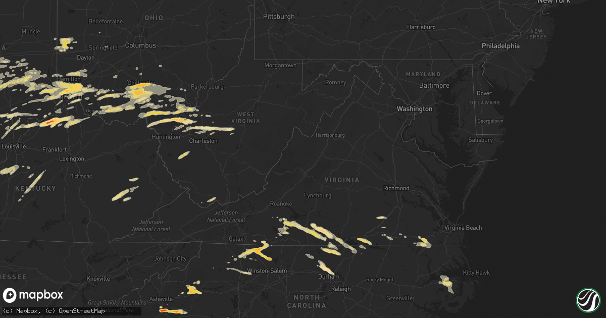
Hail Map in Virginia on May 1, 2012
Get this storm
May 1 map
$229
one time, instant access
Download today. No call, no setup
Keep the $229
Bought the map and want the full workflow? Apply the entire $229 to a subscription within 7 days. None of it is wasted.
Every map, not just this one
This buys you this map. Subscription and you get every map we run, in the markets you choose from a few cities to whole states to nationwide. Plus real-time alerts the moment a storm fires.
Contact data
Name, contact info, occupancy, even credit band for addresses in the footprint. You go from where it hit to who to call.
Become the source they trust
Unlimited branding weather history reports on demand. You already have the documented answer ready for the property owner, and you are the one who showed up with it.
Property data and RoofTrace estimates
Pull up any address you have got, its value and the exact code rules for that jurisdiction, straight from One Click Code. Then RoofTrace estimates the squares, pitch, and roof value, priced the way you price.
Storm reports in Virginia
Virginia
| Date | Description |
|---|---|
| 05/01/20126:00 PM CDT | Tree down across n. Liberty spring rd. |
| 05/01/20125:45 PM CDT | Trees down south of franklin along general thomas highway and smith ferry road. |
| 05/01/20125:30 PM CDT | Tree was downed blocking storys station road. |
| 05/01/20125:30 PM CDT | Tree down across road. |
| 05/01/20124:33 PM CDT | Trees down on oak grove rd |
| 05/01/20124:25 PM CDT | Trees down on hendricks mill rd |
| 05/01/20123:10 PM CDT | Multiple trees down on river road |
| 05/01/20123:10 PM CDT | Multiple trees down on berry hill rd |
| 05/01/20123:05 PM CDT | Kennon lane |
| 05/01/20123:00 PM CDT | Mountain road |
| 05/01/20123:00 PM CDT | A local report indicates 1.00 inch wind near HALIFAX |
| 05/01/20122:41 PM CDT | Several large trees blown down on herman farmer road...including a 100 year old oak tree. Report from wset. |
| 05/01/20122:38 PM CDT | Nickel and quarter hail covering the ground at figsboro general store. Time estimated from radar. |
| 05/01/20122:25 PM CDT | Multiple trees down on beverly heights rd |
| 05/01/20121:43 PM CDT | One tree down along route 220 |
| 05/01/20121:40 PM CDT | A local report indicates 1.00 inch wind near 5 SE ROCKY MOUNT |
All States Impacted by Hail Map on May 1, 2012
Cities Impacted by Hail Map on May 1, 2012
- Pinnacle, NC
- Cylinder, IA
- Comfrey, MN
- Pilot Mountain, NC
- Stuart, VA
- Lawsonville, NC
- Germanton, NC
- Mount Airy, NC
- Dobson, NC
- Westfield, NC
- King, NC
- State Road, NC
- Walnut Cove, NC
- Elkin, NC
- Ararat, NC
- Geddes, SD
- Bedford, KY
- Hanover, IN
- Nabb, IN
- Milton, KY
- Bethlehem, IN
- Corsica, SD
- Letts, IA
- Columbus Junction, IA
- Conesville, IA
- Gallipolis, OH
- Crown City, OH
- Patriot, OH
- Saint Peter, MN
- Sioux Rapids, IA
- Creston, NE
- Leigh, NE
- Humphrey, NE
- Long Grove, IA
- Capron, VA
- Colman, SD
- Egan, SD
- Nathalie, VA
- Java, VA
- South Boston, VA
- Vernon Hill, VA
- Halifax, VA
- Gretna, VA
- Vinton, OH
- Langsville, OH
- Leon, WV
- Sutherland, IA
- Bloomington, IN
- Loveland, OH
- Milford, OH
- Goshen, OH
- Garvin, MN
- Walnut Grove, MN
- Ruthton, MN
- Slayton, MN
- Marshall, MN
- Russell, MN
- Tracy, MN
- Balaton, MN
- Woodstock, MN
- Holland, MN
- Tyler, MN
- Currie, MN
- Chandler, MN
- Iona, MN
- Lake Wilson, MN
- Durham, NC
- Hillsborough, NC
- Rougemont, NC
- Hurdle Mills, NC
- Bahama, NC
- Hendersonville, NC
- Fletcher, NC
- Horse Shoe, NC
- Mills River, NC
- Herington, KS
- Edinburg, ND
- Hoople, ND
- Crystal, ND
- Duck, WV
- Spencer, IN
- Unionville, IN
- Ellettsville, IN
- Danville, IN
- Plainfield, IN
- Reelsville, IN
- Cloverdale, IN
- Greencastle, IN
- Rock Rapids, IA
- Doon, IA
- George, IA
- Ashland, NE
- Yutan, NE
- Waterloo, NE
- Gretna, NE
- Greenwood, NE
- Ithaca, NE
- Memphis, NE
- Sardinia, OH
- Georgetown, OH
- Russellville, OH
- Gallipolis Ferry, WV
- Apple Grove, WV
- Larchwood, IA
- Inwood, IA
- Little Rock, IA
- Ashton, IA
- Melvin, IA
- Sibley, IA
- Ocheyedan, IA
- Hills, MN
- Chillicothe, OH
- Canton, SD
- Alvord, IA
- Fairview, SD
- Hudson, SD
- Rock Valley, IA
- Belgrade, MN
- Saint Joseph, MN
- Sauk Rapids, MN
- Elrosa, MN
- Brooten, MN
- Waite Park, MN
- Freeport, MN
- Villard, MN
- Sauk Centre, MN
- Avon, MN
- Saint Cloud, MN
- Glenwood, MN
- Albany, MN
- Melrose, MN
- Foley, MN
- Sartell, MN
- Rushville, IN
- Laurel, IN
- Lehigh, IA
- Dayton, IA
- Stratford, IA
- Sleepy Eye, MN
- Burdick, KS
- Lost Springs, KS
- White City, KS
- Wheelersburg, OH
- Portsmouth, OH
- Oak Hill, OH
- Cheshire, OH
- Minford, OH
- Letart, WV
- Point Pleasant, WV
- West Columbia, WV
- Cottageville, WV
- Henderson, WV
- Bidwell, OH
- South Webster, OH
- Racine, OH
- Thurman, OH
- Mount Alto, WV
- Millwood, WV
- Coxs Creek, KY
- Baskerville, VA
- Ebony, VA
- South Hill, VA
- Bracey, VA
- La Crosse, VA
- Bainbridge, IN
- Worthville, KY
- Ghent, KY
- Sparta, KY
- Jonesville, KY
- Turners Station, KY
- Sanders, KY
- Glencoe, KY
- Dry Ridge, KY
- Carrollton, KY
- Omaha, NE
- Crescent, IA
- McClelland, IA
- Minden, IA
- Underwood, IA
- Council Bluffs, IA
- Ainsworth, NE
- Long Pine, NE
- Johnstown, NE
- Sioux Center, IA
- Bruce, SD
- Saint Stephen, MN
- Royalton, MN
- Clear Lake, MN
- Rice, MN
- Oak Park, MN
- Starbuck, MN
- Holdingford, MN
- Bowlus, MN
- Dry Fork, VA
- Chatham, VA
- Union Hall, VA
- Penhook, VA
- Rocky Mount, VA
- Glade Hill, VA
- Sutherlin, VA
- Blairs, VA
- Callands, VA
- Alton, VA
- Keeling, VA
- Morganton, NC
- Marion, NC
- Nebo, NC
- Delmont, SD
- Blanchester, OH
- Pleasant Plain, OH
- Morrow, OH
- Columbia, NC
- Morristown, IN
- Lynchburg, OH
- Fayetteville, OH
- Hillsboro, OH
- Mount Orab, OH
- Alta Vista, KS
- Dwight, KS
- Junction City, KS
- Phillips, NE
- Marquette, NE
- Aurora, NE
- Winona, MN
- Minnesota City, MN
- Pender, NE
- Bethany, MO
- Albany, MO
- New Hampton, MO
- Martinsville, MO
- Richmond, MN
- Springfield, KY
- Clearwater, MN
- Monticello, MN
- Becker, MN
- Murdock, MN
- Sunburg, MN
- Edgerton, MN
- Martinsville, IN
- Aurora, IN
- Moores Hill, IN
- Lawrenceburg, IN
- Neola, IA
- Oakland, IA
- Warwick, ND
- Crary, ND
- Lakota, ND
- Salem, SD
- Bridgewater, SD
- Emery, SD
- Madison, SD
- Spencer, SD
- Canistota, SD
- Winfred, SD
- Colton, SD
- Montrose, SD
- Chester, SD
- Greenville, MI
- Booneville, KY
- Ricetown, KY
- Buckhorn, KY
- Jackson, KY
- Catlin, IL
- Tilton, IL
- Danville, IL
- Covington, IN
- Westville, IL
- Perrysville, IN
- Breda, IA
- Ramona, SD
- Langdon, ND
- Wales, ND
- Hannah, ND
- Springfield, OH
- Raywick, KY
- Loretto, KY
- Lebanon, KY
- Saint Catharine, KY
- Heron Lake, MN
- Vevay, IN
- Gowrie, IA
- Paton, IA
- Elizabethtown, KY
- Lebanon Junction, KY
- West Point, KY
- Hazel Green, WI
- Cuba City, WI
- Batesville, IN
- Osgood, IN
- Greensburg, IN
- Wentworth, SD
- Doniphan, NE
- Okabena, MN
- Lakefield, MN
- Cincinnati, OH
- Oxford, NC
- Roxboro, NC
- York, NE
- McCool Junction, NE
- Marion, SD
- Fort Dodge, IA
- Frankfort, OH
- Greenfield, OH
- Franklin Furnace, OH
- Willow Wood, OH
- Pedro, OH
- Southside, WV
- Fraziers Bottom, WV
- Ironton, OH
- Scottown, OH
- Waterloo, OH
- Ethan, SD
- Mitchell, SD
- Jasper, MN
- Hardwick, MN
- Olivet, SD
- Kimball, MN
- South Haven, MN
- Ivydale, WV
- Wallback, WV
- Clay, WV
- Benedict, NE
- Bradshaw, NE
- Union, KY
- Hebron, KY
- Burlington, KY
- Persia, IA
- Piketon, OH
- Waverly, OH
- Trent, SD
- Pipestone, MN
- Flandreau, SD
- Pollock, MO
- Milan, MO
- Arlington, SD
- Volga, SD
- Foreston, MN
- Milaca, MN
- Clayton, IN
- Coatesville, IN
- Stilesville, IN
- Prague, NE
- Linwood, NE
- Bruno, NE
- Abie, NE
- Luverne, MN
- Whitesville, KY
- Harts, WV
- Spurlockville, WV
- Alkol, WV
- McKenney, VA
- Belmond, IA
- Clarion, IA
- Rowan, IA
- Bennington, NE
- Hartley, IA
- Sanborn, IA
- Primghar, IA
- Harris, IA
- Milford, IA
- Lake Park, IA
- Everly, IA
- Bardstown, KY
- Jackson, OH
- Latham, OH
- Albany, OH
- Hamden, OH
- West Union, OH
- Seaman, OH
- South Salem, OH
- Bainbridge, OH
- Ray, OH
- Winchester, OH
- Blue Creek, OH
- Beaver, OH
- McArthur, OH
- Ripley, OH
- Peebles, OH
- Londonderry, OH
- Wellston, OH
- Otway, OH
- Lucasville, OH
- Rarden, OH
- McDermott, OH
- Fairland, IN
- Arlington, IN
- Shelbyville, IN
- Manilla, IN
- Austin, IN
- Deputy, IN
- Crothersville, IN
- Scottsburg, IN
- Paris Crossing, IN
- Brownstown, IN
- Vallonia, IN
- Granger, IA
- Woodward, IA
- Manchester, IA
- Rockville, IN
- Brazil, IN
- Hamilton, OH
- Charleston, WV
- Tolna, ND
- Arcanum, OH
- Greenville, OH
- Mason, OH
- Gosport, IN
- Nashville, IN
- Alexandria, SD
- Jamestown, IN
- Thorntown, IN
- Argyle, WI
- Mineral Point, WI
- Blanchardville, WI
- Darlington, WI
- Camby, IN
- Bee, NE
- Seward, NE
- Staplehurst, NE
- Webster, IA
- Keswick, IA
- Seymour, IN
- North Vernon, IN
- Commiskey, IN
- Fulton, SD
- Campbellsburg, IN
- Bedford, IN
- Orleans, IN
- Mitchell, IN
- Mill Spring, NC
- Rutherfordton, NC
- Lake Lure, NC
- Bingham Lake, MN
- Mountain Lake, MN
- Cleves, OH
- Addyston, OH
- North Bend, OH
- Lexington, IN
- Maynard, MN
- Montevideo, MN
- Burke, SD
- Cavalier, ND
- Hensel, ND
- Clarksville, VA
- Bloomfield, IN
- Morris, MN
- Valley Springs, SD
- Beaver Creek, MN
- Princeton, MN
- Springfield, MN
- Sanborn, MN
- Falls Of Rough, KY
- Utica, NE
- Waco, NE
- Martinsville, VA
- David City, NE
- Rising City, NE
- Ridgeway, MO
- Deep River, IA
- Buffalo, WV
- Greenup, KY
- New Madison, OH
- Radcliff, KY
- Rineyville, KY
- Fort Knox, KY
- Vine Grove, KY
- Guilford, IN
- Sunman, IN
- West Harrison, IN
- Milan, IN
- Harrison, OH
- Nelson, VA
- Buffalo Junction, VA
- Virgilina, VA
- Solsberry, IN
- Middletown, OH
- Topeka, KS
- Indianapolis, IN
- Mooresville, IN
- Verona, KY
- Warsaw, KY
- Patriot, IN
- Stromsburg, NE
- Shelby, IA
- Otisco, IN
- Marysville, IN
- Henryville, IN
- Creswell, NC
- Spencer, IA
- Ripley, WV
- Gay, WV
- Suffolk, VA
- Franklin, VA
- Osceola, NE
- Shelby, NE
- Polk, NE
- Rutland, OH
- Roaring River, NC
- North Wilkesboro, NC
- Ronda, NC
- Walhalla, ND
- Anawalt, WV
- Welch, WV
- Evans, WV
- Eldora, IA
- Humboldt, SD
- Hartford, SD
- Estelline, SD
- Walton, WV
- Gandeeville, WV
- Canova, SD
- Mocksville, NC
- Yadkinville, NC
- Hamptonville, NC
- Harmony, NC
- Columbus, IN
- Hartsville, IN
- Arden, NC
- Papillion, NE
- Springfield, NE
- Stanleytown, VA
- Bassett, VA
- Collinsville, VA
- Fieldale, VA
- Carter Lake, IA
- Honey Creek, IA
- Elkhorn, NE
- Boys Town, NE
- Valley, NE
- Herrick, SD
- Wall, SD
- Quinn, SD
- Philip, SD
- Scotland, IN
- Newberry, IN
- Crane, IN
- Avoca, IN
- Odon, IN
- Owensburg, IN
- Springville, IN
- Stanchfield, MN
- Cambridge, MN
- Okeana, OH
- Fairfield, OH
- North English, IA
- Parnell, IA
- Milan, MN
- Watson, MN
- Reedy, WV
- Spencer, WV
- Hornick, IA
- Rodney, IA
- Saint Paul, IN
- Milroy, IN
- Morgantown, IN
- Nineveh, IN
- Hope, IN
- Taylorsville, IN
- Flat Rock, IN
- Edinburgh, IN
- Missouri Valley, IA
- Modale, IA
- Logan, IA
- Arlington, NE
- Blair, NE
- Kennard, NE
- Palestine, OH
- Eldorado, OH
- West Manchester, OH
- Bradford, OH
- Richmond, IN
- Lewisburg, OH
- New Paris, OH
- Henderson, NC
- Bullock, NC
- Callaway, VA
- Ceresco, NE
- Valparaiso, NE
- Davey, NE
- Gresham, NE
- Malcolm, NE
- Garland, NE
- Raymond, NE
- Roscoe, MN
- Paynesville, MN
- Roper, NC
- Redwood Falls, MN
- New Boston, IL
- Lake Andes, SD
- Armour, SD
- Pierz, MN
- Holton, IN
- Miamiville, OH
- Petersburg, KY
- West Chester, OH
- Camp Dennison, OH
- Batavia, OH
- Schuyler, NE
- Latonia, KY
- Newport, KY
- Melbourne, KY
- Silver Grove, KY
- Sarles, ND
- New Ulm, MN
- Morgan, MN
- Wellman, IA
- Ivesdale, IL
- Fithian, IL
- Oakwood, IL
- Veedersburg, IN
- Fairmount, IL
- Ranger, WV
- Bassett, NE
- Eagle Grove, IA
- Homer, IL
- Ogden, IL
- Red House, WV
- Copper Hill, VA
- Avoca, IA
- Poca, WV
- South English, IA
- Osage, IA
- Urbana, IL
- Sidney, IL
- Saint Joseph, IL
- Fillmore, IN
- Salyersville, KY
- Procious, WV
- Newton, WV
- Dimock, SD
- Parkston, SD
- Liberty, WV
- Mapleton, IA
- Ute, IA
- Ames, NE
- Fremont, NE
- Nickerson, NE
- Hooper, NE
- North Bend, NE
- New Palestine, IN
- Pekin, IN
- Summersville, KY
- Greensburg, KY
- Leesburg, OH
- Sabina, OH
- Washington Court House, OH
- Springville, IA
- Anamosa, IA
- Hays, NC
- New Washington, IN
- New Windsor, IL
- Grafton, ND
- Stephen, MN
- Aledo, IL
- Joy, IL
- Waverly, NE
- Wahoo, NE
- Hancock, IA
- Washington, NE
- Fort Calhoun, NE
- Amma, WV
- Kenna, WV
- Clendenin, WV
- Elkview, WV
- Arvilla, ND
- Larimore, ND
- Rowdy, KY
- Chavies, KY
- Krypton, KY
- Hazard, KY
- Sadorus, IL
- Tolono, IL
- Crawfordsville, IN
- Hillsboro, IN
- Darlington, IN
- Waynetown, IN
- Vincennes, IN
- Emporia, VA
- Freeman, VA
- Vinton, IA
- Claudville, VA
- Seymour, WI
- McFall, MO
- Vail, IA
- Guernsey, IA
- Victor, IA
- Coffey, MO
- Pattonsburg, MO
- Hordville, NE
- Hampton, NE
- Carroll, IA
- Whick, KY
- Mistletoe, KY
- Gays Creek, KY
- Lost Creek, KY
- Clayhole, KY
- Salem, IN
- Peterson, IA
- Mead, NE
- Colon, NE
- Benson, MN
- Danvers, MN
- Charter Oak, IA
- Schleswig, IA
- Ricketts, IA
- Deloit, IA
- Denison, IA
- Soldier, IA
- Kiron, IA
- Castana, IA
- Battle Creek, IA
- Middleport, OH
- Hillsboro, WI
- Circleville, OH
- Muncie, IL
- Philo, IL
- Carthage, IN
- Bellevue, IA
- Galena, IL
- Plainville, IN
- Bicknell, IN
- Washington, IN
- Edwardsport, IN
- Henry, VA
- Lewiston, MN
- Alpha, IL
- North Henderson, IL
- Alexis, IL
- Rio, IL
- Borden, IN
- Williamstown, KY
- Falmouth, KY
- West Portsmouth, OH
- Ravenswood, WV
- Pomeroy, OH
- Archer, IA
- Hull, IA
- Sheldon, IA
- Boyden, IA
- Alcester, SD
- Beresford, SD
- Steen, MN
- Hawarden, IA
- Matlock, IA
- Lyndon Station, WI
- New Ross, IN
- Savoy, IL
- Franklin, IN
- Laura, OH
- Ludlow Falls, OH
- Semora, NC
- Columbus, NE
- Platte Center, NE
- Rockford, IA
- Dougherty, IA
- Lewis, IA
- Griswold, IA
- Potosi, WI
- Dickeyville, WI
- Montgomery, IN
- Loogootee, IN
- Tecumseh, KS
- Cold Spring, MN
- Dayton, KY
- Owenton, KY
- Granite Falls, MN
- Como, NC
- Gates, NC
- Corapeake, NC
- Butterfield, MN
- Henderson, NE
- Ulysses, NE
- Scottsburg, VA
- Manson, NC
- Gratiot, WI
- South Wayne, WI
- Brodnax, VA
- Shade, OH
- Athens, OH
- Garnavillo, IA
- Farmersburg, IA
- Wheatland, IN
- Trenton, OH
- Franklin, OH
- Custer, KY
- Ekron, KY
- Hardinsburg, KY
- Westview, KY
- Guston, KY
- Harned, KY
- Irvington, KY
- Garfield, KY
- Shepherdsville, KY
- Iowa Falls, IA
- Isanti, MN
- Independence, IA
- Cedar Grove, NC
- Timberlake, NC
- Urbana, OH
- Saint Paris, OH
- Ainsworth, IA
- Washington, IA
- Zimmerman, MN
- Elk River, MN
- Big Lake, MN
- Underwood, IN
- Lamberton, MN
- Revere, MN
- Salix, IA
- Sloan, IA
- Malcom, IA
- Grinnell, IA
- Hartford, KY
- Monroe City, IN
- Imperial, TX
- Hatfield, MO
- Drayton, ND
- Fairview, NC
- Fordsville, KY
- Reynolds Station, KY
- Kalona, IA
- Terrace Park, OH
- Covington, KY
- Bellevue, KY
- Fort Thomas, KY
- Brookings, SD
- Windom, MN
- Holy Cross, IA
- McGregor, IA
- Sabula, IA
- Clinton, IA
- De Witt, IA
- Delmar, IA
- Warrenton, NC
- Freeman, SD
- Fairmont, MN
- Granada, MN
- Tripp, SD
- Sod, WV
- Sumerco, WV
- Union Grove, NC
- Wilkesboro, NC
- Round Lake, MN
- Worthington, MN
- Maineville, OH
- Seaton, IL
- Keithsburg, IL
- Mebane, NC
- Yanceyville, NC
- Burlington, NC
- Harrodsburg, KY
- Willisburg, KY
- Dell Rapids, SD
- Harrison, SD
- Amelia, OH
- Collettsville, NC
- Lenoir, NC
- Sutton, NE
- Saronville, NE
- Grafton, NE
- Harvard, NE
- Masonville, IA
- Campbellsville, KY
- Glenwood, WV
- Ashton, WV
- Lesage, WV
- Crittenden, KY
- New Liberty, KY
- Grant City, MO
- Dillsboro, IN
- Fountaintown, IN
- Jackson, WI
- Eagleville, MO
- Lecompton, KS
- Dunkerton, IA
- Denver, IA
- Readlyn, IA
- Arcadia, IA
- Portsmouth, IA
- Steamboat Rock, IA
- Whiteland, IN
- Greenwood, IN
- Needham, IN
- Boggstown, IN
- Wasta, SD
- New Underwood, SD
- Owanka, SD
- Muscatine, IA
- De Mossville, KY
- Campbellsburg, KY
- Newport, NE
- Odin, MN
- Trimont, MN
- Morse Bluff, NE
- Michigan, ND
- Elnora, IN
- Luana, IA
- Postville, IA
- Elgin, IA
- Monona, IA
- Central City, IA
- Warfield, VA
- Bancroft, IA
- Whittemore, IA
- Harris, MN
- North Branch, MN
- Grandy, MN
- Lake View, IA
- Wall Lake, IA
- Odebolt, IA
- Switchback, WV
- Maybeury, WV
- Northfork, WV
- Sheffield, IA
- Greenville, IN
- Taunton, MN
- Minneota, MN
- Boyd, MN
- Williamsburg, OH
- Platte, SD
- Winnebago, MN
- Blue Earth, MN
- Stanberry, MO
- Madison, IN
- Walnut, IA
- Monticello, IA
- Hopkinton, IA
- Earlville, IA
- Dyersville, IA
- Delhi, IA
- Butlerville, IN
- Williamsport, OH
- Wilsey, KS
- Ceylon, MN
- Sandborn, IN
- Westphalia, IN
- Versailles, IN
- Glenwood, IN
- Bargersville, IN
- Waldron, IN
- Trafalgar, IN
- New Trenton, IN
- Metamora, IN
- Clifford, IN
- Connersville, IN
- Napoleon, IN
- Ft Mitchell, KY
- Hooven, OH
- Cedar Grove, IN
- Westport, IN
- Brookville, IN
- Oldenburg, IN
- Malmo, NE
- Alexandria, KY
- Independence, KY
- Walton, KY
- Morning View, KY
- Butler, KY
- Brooksville, KY
- Foster, KY
- Seven Mile, OH
- Monroe, OH
- Lebanon, OH
- Norlina, NC
- Macon, NC
- Canby, MN
- Bennett, IA
- Lynn, IN
- Union City, IN
- Olin, IA
- Algona, IA
- Wapello, IA
- Clarkfield, MN
- Hendricks, MN
- Shoals, IN
- Williams, IN
- Delavan, MN
- Skippers, VA
- Ferguson, NC
- Canaan, IN
- Bennington, IN
- Lake City, IA
- Lohrville, IA
- Churdan, IA
- Hamersville, OH
- Felicity, OH
- Traer, IA
- Winnebago, NE
- Macy, NE
- Boones Mill, VA
- Shullsburg, WI
- Leota, MN
- Traphill, NC
- Stanley, IA
- La Motte, IA
- Maquoketa, IA
- Vesta, MN
- Wabasso, MN
- Scales Mound, IL
- Harlan, IA
- Howard, SD
- Hixton, WI
- Pleasantville, IA
- Champaign, IL
- Bethel, OH
- Harris, MO
- Galt, MO
- Waynesville, OH
- Springboro, OH
- Duncombe, IA
- Otho, IA
- Harcourt, IA
- Burnside, IA
- Dewitt, VA
- Lucan, MN
- Cedar Bluffs, NE
- Howells, NE
- Clarkson, NE
- Tipton, IA
- Brayton, IA
- Granville, IA
- Hospers, IA
- Scottsville, KY
- Wilkesville, OH
- Meadows Of Dan, VA
- Ararat, VA
- Dawson, MN
- Old Fort, NC
- Milroy, MN
- Aurora, IA
- Mount Vernon, SD
- Paullina, IA
- Monroe, SD
- Putnamville, IN
- West Newton, IN
- Avon, IN
- Beech Grove, IN
- Brooklyn, IN
- Monrovia, IN
- Siloam, NC
- Bagley, WI
- Sandy Ridge, NC
- Roachdale, IN
- Westside, IA
- Oldham, SD
- Early, IA
- Linn Grove, IA
- Sugar Grove, OH
- Lancaster, OH
- Reeseville, WI
- Madrid, IA
- Illinois City, IL
- Fruitland, IA
- Reynolds, IL
- War, WV
- Berwind, WV
- Clay Center, NE
- Pilger, NE
- Wisner, NE
- Stanton, NE
- Newsoms, VA
- Ellsworth, MN
- Adrian, MN
- Verona, OH
- Brookville, OH
- Advent, WV
- Eleanor, WV
- Winfield, WV
- Hurricane, WV
- Milton, WV
- Cedar Falls, IA
- Janesville, IA
- Waterloo, IA
- Bath, IN
- Oxford, OH
- Watkins, MN
- Viola, IL
- Pittsboro, IN
- North Salem, IN
- Brownsburg, IN
- Thurston, NE
- Walthill, NE
- Whiting, IA
- Mountain, ND
- Pella, IA
- Emmetsburg, IA
- Ayrshire, IA
- Ruthven, IA
- New Vienna, IA
- Erlanger, KY
- Coon Rapids, IA
- Audubon, IA
- Guthrie Center, IA
- Webster City, IA
- Hamlin, IA
- Wood Lake, NE
- Lancaster, WI
- Panama, IA
- White, SD
- Thompson, ND
- Griffithsville, WV
- Giltner, NE
- Florence, IN
- Ormsby, MN
- Holland, IA
- Grundy Center, IA
- Wellsburg, IA


