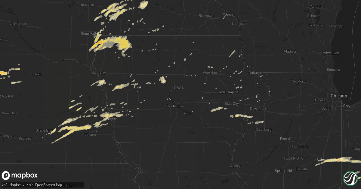
Hail Map in Iowa on May 1, 2012
Get this storm
May 1 map
$229
one time, instant access
Download today. No call, no setup
Keep the $229
Bought the map and want the full workflow? Apply the entire $229 to a subscription within 7 days. None of it is wasted.
Every map, not just this one
This buys you this map. Subscription and you get every map we run, in the markets you choose from a few cities to whole states to nationwide. Plus real-time alerts the moment a storm fires.
Contact data
Name, contact info, occupancy, even credit band for addresses in the footprint. You go from where it hit to who to call.
Become the source they trust
Unlimited branding weather history reports on demand. You already have the documented answer ready for the property owner, and you are the one who showed up with it.
Property data and RoofTrace estimates
Pull up any address you have got, its value and the exact code rules for that jurisdiction, straight from One Click Code. Then RoofTrace estimates the squares, pitch, and roof value, priced the way you price.
Storm reports in Iowa
Iowa
| Date | Description |
|---|---|
| 05/01/20124:52 AM CDT | Report of a few 2 inch tree limbs down in the city. Time estimated from radar. |
| 05/01/20124:50 AM CDT | Report of several branches down about 6 inches in diameter. Time estimated from radar. |
| 05/01/20124:39 AM CDT | Time estimated from radar. |
| 05/01/20123:35 AM CDT | Large tree blown over near interesection of 51st st and 32nd ave...roof blown off barn...1 grain bin blown out...time estimated from radar. |
| 05/01/20122:40 AM CDT | Large limb toppled a power line which fell across ia-175 in reinbeck. Several other large limbs down across the west side of town. Time estimated from radar. |
| 05/01/20122:23 AM CDT | Emergency manager reported 4 1 1/2 foot diameter evergrren trees downed and a roof torn off a barn nw corner of boone. Also from 1n boone to the eastern border of boone |
| 05/01/20122:16 AM CDT | Several 10-inch limbs down. Time estimated from radar. |
| 05/01/20121:59 AM CDT | The top of a tree two foot in diameter was snapped off in the town of roland. Time estimated from radar. |
| 05/01/20121:55 AM CDT | Wind damage to trees |
| 05/01/20121:53 AM CDT | Power lines reported down in the city of ames. |
| 05/01/20121:52 AM CDT | Pine tree uprooted and multiple tree limbs down. |
| 05/01/20121:52 AM CDT | Measured at the ames mesonet site. |
| 05/01/20121:51 AM CDT | Tree landed on a house and on a car in the area of nixon circle in ames. Additionally...the tree damaged the gas line to the house. Time estimated from radar. |
| 05/01/20121:50 AM CDT | Garage doors blown in with gutters torn off. Apartment complex in north ames. From isu meteorology student. |
| 05/01/20121:50 AM CDT | Damage report within two blocks of bloomington road and grand...shingles off house roofs...privacy fences down..apartment building lost partial balcony...trees of one t |
| 05/01/20121:40 AM CDT | Several large limbs down and damage to fences. Damage began about 1 mile south of fraser and continued sporadically for about the next 2 miles |
| 05/01/20121:36 AM CDT | A local report indicates 1.00 inch wind near 2 SW VOLNEY |
| 05/01/20121:27 AM CDT | Several 6-inch tree limbs down. Time estimated from radar. |
| 04/30/201211:34 PM CDT | Trained spotter reported quarter sized hail blowing vertically against the window. Estimated at least 60 mph wind gusts |
| 04/30/201210:55 PM CDT | Trained spotter driving on highway 15 between whittemore and fenton estimated 60 mph winds and had trouble controlling his car. Reported several cars in the ditch and q |
| 04/30/201210:20 PM CDT | Horizontal rain and numerous 6 inche tree branches down. |
| 04/30/201210:18 PM CDT | Damage to roof. |
| 04/30/201210:06 PM CDT | Measured by rwis. |
| 04/30/20129:56 PM CDT | A local report indicates 60 MPH wind near 3 N ROYAL |
| 04/30/20129:55 PM CDT | Numerous trees down and some windows blown out of buildings. |
| 04/30/20129:44 PM CDT | 70-80 mph wind gust |
| 04/30/20129:40 PM CDT | Several power poles leaning along 130th avenue south of everly. |
| 04/30/20129:40 PM CDT | A local report indicates a tornado near 3 SW EVERLY |
| 04/30/20129:35 PM CDT | A local report indicates 70 MPH wind near 1 S OCHEYEDAN |
| 04/30/20129:20 PM CDT | Numerous 1 to 3 inch diameter tree branches blown down. |
| 04/30/20129:17 PM CDT | Damage to several outbuildings to three farmsteads. Winds estimated between 70 and 85 mph. |
| 04/30/20129:15 PM CDT | A local report indicates 74 MPH wind near SHELDON |
| 04/30/20129:00 PM CDT | Measured by rwis station. |
| 04/30/20128:15 PM CDT | A local report indicates 1.00 inch wind near 5 E ALVORD |
| 04/30/20127:45 PM CDT | Combination of hail and strong winds stripped leaves from trees. |
| 04/30/20127:34 PM CDT | Hail occurred with 50 to 55 mph winds. |
| 04/30/20127:22 PM CDT | A local report indicates 1.50 inch wind near 5 SE CANTON |
All States Impacted by Hail Map on May 1, 2012
Cities Impacted by Hail Map on May 1, 2012
- Pinnacle, NC
- Cylinder, IA
- Comfrey, MN
- Pilot Mountain, NC
- Stuart, VA
- Lawsonville, NC
- Germanton, NC
- Mount Airy, NC
- Dobson, NC
- Westfield, NC
- King, NC
- State Road, NC
- Walnut Cove, NC
- Elkin, NC
- Ararat, NC
- Geddes, SD
- Bedford, KY
- Hanover, IN
- Nabb, IN
- Milton, KY
- Bethlehem, IN
- Corsica, SD
- Letts, IA
- Columbus Junction, IA
- Conesville, IA
- Gallipolis, OH
- Crown City, OH
- Patriot, OH
- Saint Peter, MN
- Sioux Rapids, IA
- Creston, NE
- Leigh, NE
- Humphrey, NE
- Long Grove, IA
- Capron, VA
- Colman, SD
- Egan, SD
- Nathalie, VA
- Java, VA
- South Boston, VA
- Vernon Hill, VA
- Halifax, VA
- Gretna, VA
- Vinton, OH
- Langsville, OH
- Leon, WV
- Sutherland, IA
- Bloomington, IN
- Loveland, OH
- Milford, OH
- Goshen, OH
- Garvin, MN
- Walnut Grove, MN
- Ruthton, MN
- Slayton, MN
- Marshall, MN
- Russell, MN
- Tracy, MN
- Balaton, MN
- Woodstock, MN
- Holland, MN
- Tyler, MN
- Currie, MN
- Chandler, MN
- Iona, MN
- Lake Wilson, MN
- Durham, NC
- Hillsborough, NC
- Rougemont, NC
- Hurdle Mills, NC
- Bahama, NC
- Hendersonville, NC
- Fletcher, NC
- Horse Shoe, NC
- Mills River, NC
- Herington, KS
- Edinburg, ND
- Hoople, ND
- Crystal, ND
- Duck, WV
- Spencer, IN
- Unionville, IN
- Ellettsville, IN
- Danville, IN
- Plainfield, IN
- Reelsville, IN
- Cloverdale, IN
- Greencastle, IN
- Rock Rapids, IA
- Doon, IA
- George, IA
- Ashland, NE
- Yutan, NE
- Waterloo, NE
- Gretna, NE
- Greenwood, NE
- Ithaca, NE
- Memphis, NE
- Sardinia, OH
- Georgetown, OH
- Russellville, OH
- Gallipolis Ferry, WV
- Apple Grove, WV
- Larchwood, IA
- Inwood, IA
- Little Rock, IA
- Ashton, IA
- Melvin, IA
- Sibley, IA
- Ocheyedan, IA
- Hills, MN
- Chillicothe, OH
- Canton, SD
- Alvord, IA
- Fairview, SD
- Hudson, SD
- Rock Valley, IA
- Belgrade, MN
- Saint Joseph, MN
- Sauk Rapids, MN
- Elrosa, MN
- Brooten, MN
- Waite Park, MN
- Freeport, MN
- Villard, MN
- Sauk Centre, MN
- Avon, MN
- Saint Cloud, MN
- Glenwood, MN
- Albany, MN
- Melrose, MN
- Foley, MN
- Sartell, MN
- Rushville, IN
- Laurel, IN
- Lehigh, IA
- Dayton, IA
- Stratford, IA
- Sleepy Eye, MN
- Burdick, KS
- Lost Springs, KS
- White City, KS
- Wheelersburg, OH
- Portsmouth, OH
- Oak Hill, OH
- Cheshire, OH
- Minford, OH
- Letart, WV
- Point Pleasant, WV
- West Columbia, WV
- Cottageville, WV
- Henderson, WV
- Bidwell, OH
- South Webster, OH
- Racine, OH
- Thurman, OH
- Mount Alto, WV
- Millwood, WV
- Coxs Creek, KY
- Baskerville, VA
- Ebony, VA
- South Hill, VA
- Bracey, VA
- La Crosse, VA
- Bainbridge, IN
- Worthville, KY
- Ghent, KY
- Sparta, KY
- Jonesville, KY
- Turners Station, KY
- Sanders, KY
- Glencoe, KY
- Dry Ridge, KY
- Carrollton, KY
- Omaha, NE
- Crescent, IA
- McClelland, IA
- Minden, IA
- Underwood, IA
- Council Bluffs, IA
- Ainsworth, NE
- Long Pine, NE
- Johnstown, NE
- Sioux Center, IA
- Bruce, SD
- Saint Stephen, MN
- Royalton, MN
- Clear Lake, MN
- Rice, MN
- Oak Park, MN
- Starbuck, MN
- Holdingford, MN
- Bowlus, MN
- Dry Fork, VA
- Chatham, VA
- Union Hall, VA
- Penhook, VA
- Rocky Mount, VA
- Glade Hill, VA
- Sutherlin, VA
- Blairs, VA
- Callands, VA
- Alton, VA
- Keeling, VA
- Morganton, NC
- Marion, NC
- Nebo, NC
- Delmont, SD
- Blanchester, OH
- Pleasant Plain, OH
- Morrow, OH
- Columbia, NC
- Morristown, IN
- Lynchburg, OH
- Fayetteville, OH
- Hillsboro, OH
- Mount Orab, OH
- Alta Vista, KS
- Dwight, KS
- Junction City, KS
- Phillips, NE
- Marquette, NE
- Aurora, NE
- Winona, MN
- Minnesota City, MN
- Pender, NE
- Bethany, MO
- Albany, MO
- New Hampton, MO
- Martinsville, MO
- Richmond, MN
- Springfield, KY
- Clearwater, MN
- Monticello, MN
- Becker, MN
- Murdock, MN
- Sunburg, MN
- Edgerton, MN
- Martinsville, IN
- Aurora, IN
- Moores Hill, IN
- Lawrenceburg, IN
- Neola, IA
- Oakland, IA
- Warwick, ND
- Crary, ND
- Lakota, ND
- Salem, SD
- Bridgewater, SD
- Emery, SD
- Madison, SD
- Spencer, SD
- Canistota, SD
- Winfred, SD
- Colton, SD
- Montrose, SD
- Chester, SD
- Greenville, MI
- Booneville, KY
- Ricetown, KY
- Buckhorn, KY
- Jackson, KY
- Catlin, IL
- Tilton, IL
- Danville, IL
- Covington, IN
- Westville, IL
- Perrysville, IN
- Breda, IA
- Ramona, SD
- Langdon, ND
- Wales, ND
- Hannah, ND
- Springfield, OH
- Raywick, KY
- Loretto, KY
- Lebanon, KY
- Saint Catharine, KY
- Heron Lake, MN
- Vevay, IN
- Gowrie, IA
- Paton, IA
- Elizabethtown, KY
- Lebanon Junction, KY
- West Point, KY
- Hazel Green, WI
- Cuba City, WI
- Batesville, IN
- Osgood, IN
- Greensburg, IN
- Wentworth, SD
- Doniphan, NE
- Okabena, MN
- Lakefield, MN
- Cincinnati, OH
- Oxford, NC
- Roxboro, NC
- York, NE
- McCool Junction, NE
- Marion, SD
- Fort Dodge, IA
- Frankfort, OH
- Greenfield, OH
- Franklin Furnace, OH
- Willow Wood, OH
- Pedro, OH
- Southside, WV
- Fraziers Bottom, WV
- Ironton, OH
- Scottown, OH
- Waterloo, OH
- Ethan, SD
- Mitchell, SD
- Jasper, MN
- Hardwick, MN
- Olivet, SD
- Kimball, MN
- South Haven, MN
- Ivydale, WV
- Wallback, WV
- Clay, WV
- Benedict, NE
- Bradshaw, NE
- Union, KY
- Hebron, KY
- Burlington, KY
- Persia, IA
- Piketon, OH
- Waverly, OH
- Trent, SD
- Pipestone, MN
- Flandreau, SD
- Pollock, MO
- Milan, MO
- Arlington, SD
- Volga, SD
- Foreston, MN
- Milaca, MN
- Clayton, IN
- Coatesville, IN
- Stilesville, IN
- Prague, NE
- Linwood, NE
- Bruno, NE
- Abie, NE
- Luverne, MN
- Whitesville, KY
- Harts, WV
- Spurlockville, WV
- Alkol, WV
- McKenney, VA
- Belmond, IA
- Clarion, IA
- Rowan, IA
- Bennington, NE
- Hartley, IA
- Sanborn, IA
- Primghar, IA
- Harris, IA
- Milford, IA
- Lake Park, IA
- Everly, IA
- Bardstown, KY
- Jackson, OH
- Latham, OH
- Albany, OH
- Hamden, OH
- West Union, OH
- Seaman, OH
- South Salem, OH
- Bainbridge, OH
- Ray, OH
- Winchester, OH
- Blue Creek, OH
- Beaver, OH
- McArthur, OH
- Ripley, OH
- Peebles, OH
- Londonderry, OH
- Wellston, OH
- Otway, OH
- Lucasville, OH
- Rarden, OH
- McDermott, OH
- Fairland, IN
- Arlington, IN
- Shelbyville, IN
- Manilla, IN
- Austin, IN
- Deputy, IN
- Crothersville, IN
- Scottsburg, IN
- Paris Crossing, IN
- Brownstown, IN
- Vallonia, IN
- Granger, IA
- Woodward, IA
- Manchester, IA
- Rockville, IN
- Brazil, IN
- Hamilton, OH
- Charleston, WV
- Tolna, ND
- Arcanum, OH
- Greenville, OH
- Mason, OH
- Gosport, IN
- Nashville, IN
- Alexandria, SD
- Jamestown, IN
- Thorntown, IN
- Argyle, WI
- Mineral Point, WI
- Blanchardville, WI
- Darlington, WI
- Camby, IN
- Bee, NE
- Seward, NE
- Staplehurst, NE
- Webster, IA
- Keswick, IA
- Seymour, IN
- North Vernon, IN
- Commiskey, IN
- Fulton, SD
- Campbellsburg, IN
- Bedford, IN
- Orleans, IN
- Mitchell, IN
- Mill Spring, NC
- Rutherfordton, NC
- Lake Lure, NC
- Bingham Lake, MN
- Mountain Lake, MN
- Cleves, OH
- Addyston, OH
- North Bend, OH
- Lexington, IN
- Maynard, MN
- Montevideo, MN
- Burke, SD
- Cavalier, ND
- Hensel, ND
- Clarksville, VA
- Bloomfield, IN
- Morris, MN
- Valley Springs, SD
- Beaver Creek, MN
- Princeton, MN
- Springfield, MN
- Sanborn, MN
- Falls Of Rough, KY
- Utica, NE
- Waco, NE
- Martinsville, VA
- David City, NE
- Rising City, NE
- Ridgeway, MO
- Deep River, IA
- Buffalo, WV
- Greenup, KY
- New Madison, OH
- Radcliff, KY
- Rineyville, KY
- Fort Knox, KY
- Vine Grove, KY
- Guilford, IN
- Sunman, IN
- West Harrison, IN
- Milan, IN
- Harrison, OH
- Nelson, VA
- Buffalo Junction, VA
- Virgilina, VA
- Solsberry, IN
- Middletown, OH
- Topeka, KS
- Indianapolis, IN
- Mooresville, IN
- Verona, KY
- Warsaw, KY
- Patriot, IN
- Stromsburg, NE
- Shelby, IA
- Otisco, IN
- Marysville, IN
- Henryville, IN
- Creswell, NC
- Spencer, IA
- Ripley, WV
- Gay, WV
- Suffolk, VA
- Franklin, VA
- Osceola, NE
- Shelby, NE
- Polk, NE
- Rutland, OH
- Roaring River, NC
- North Wilkesboro, NC
- Ronda, NC
- Walhalla, ND
- Anawalt, WV
- Welch, WV
- Evans, WV
- Eldora, IA
- Humboldt, SD
- Hartford, SD
- Estelline, SD
- Walton, WV
- Gandeeville, WV
- Canova, SD
- Mocksville, NC
- Yadkinville, NC
- Hamptonville, NC
- Harmony, NC
- Columbus, IN
- Hartsville, IN
- Arden, NC
- Papillion, NE
- Springfield, NE
- Stanleytown, VA
- Bassett, VA
- Collinsville, VA
- Fieldale, VA
- Carter Lake, IA
- Honey Creek, IA
- Elkhorn, NE
- Boys Town, NE
- Valley, NE
- Herrick, SD
- Wall, SD
- Quinn, SD
- Philip, SD
- Scotland, IN
- Newberry, IN
- Crane, IN
- Avoca, IN
- Odon, IN
- Owensburg, IN
- Springville, IN
- Stanchfield, MN
- Cambridge, MN
- Okeana, OH
- Fairfield, OH
- North English, IA
- Parnell, IA
- Milan, MN
- Watson, MN
- Reedy, WV
- Spencer, WV
- Hornick, IA
- Rodney, IA
- Saint Paul, IN
- Milroy, IN
- Morgantown, IN
- Nineveh, IN
- Hope, IN
- Taylorsville, IN
- Flat Rock, IN
- Edinburgh, IN
- Missouri Valley, IA
- Modale, IA
- Logan, IA
- Arlington, NE
- Blair, NE
- Kennard, NE
- Palestine, OH
- Eldorado, OH
- West Manchester, OH
- Bradford, OH
- Richmond, IN
- Lewisburg, OH
- New Paris, OH
- Henderson, NC
- Bullock, NC
- Callaway, VA
- Ceresco, NE
- Valparaiso, NE
- Davey, NE
- Gresham, NE
- Malcolm, NE
- Garland, NE
- Raymond, NE
- Roscoe, MN
- Paynesville, MN
- Roper, NC
- Redwood Falls, MN
- New Boston, IL
- Lake Andes, SD
- Armour, SD
- Pierz, MN
- Holton, IN
- Miamiville, OH
- Petersburg, KY
- West Chester, OH
- Camp Dennison, OH
- Batavia, OH
- Schuyler, NE
- Latonia, KY
- Newport, KY
- Melbourne, KY
- Silver Grove, KY
- Sarles, ND
- New Ulm, MN
- Morgan, MN
- Wellman, IA
- Ivesdale, IL
- Fithian, IL
- Oakwood, IL
- Veedersburg, IN
- Fairmount, IL
- Ranger, WV
- Bassett, NE
- Eagle Grove, IA
- Homer, IL
- Ogden, IL
- Red House, WV
- Copper Hill, VA
- Avoca, IA
- Poca, WV
- South English, IA
- Osage, IA
- Urbana, IL
- Sidney, IL
- Saint Joseph, IL
- Fillmore, IN
- Salyersville, KY
- Procious, WV
- Newton, WV
- Dimock, SD
- Parkston, SD
- Liberty, WV
- Mapleton, IA
- Ute, IA
- Ames, NE
- Fremont, NE
- Nickerson, NE
- Hooper, NE
- North Bend, NE
- New Palestine, IN
- Pekin, IN
- Summersville, KY
- Greensburg, KY
- Leesburg, OH
- Sabina, OH
- Washington Court House, OH
- Springville, IA
- Anamosa, IA
- Hays, NC
- New Washington, IN
- New Windsor, IL
- Grafton, ND
- Stephen, MN
- Aledo, IL
- Joy, IL
- Waverly, NE
- Wahoo, NE
- Hancock, IA
- Washington, NE
- Fort Calhoun, NE
- Amma, WV
- Kenna, WV
- Clendenin, WV
- Elkview, WV
- Arvilla, ND
- Larimore, ND
- Rowdy, KY
- Chavies, KY
- Krypton, KY
- Hazard, KY
- Sadorus, IL
- Tolono, IL
- Crawfordsville, IN
- Hillsboro, IN
- Darlington, IN
- Waynetown, IN
- Vincennes, IN
- Emporia, VA
- Freeman, VA
- Vinton, IA
- Claudville, VA
- Seymour, WI
- McFall, MO
- Vail, IA
- Guernsey, IA
- Victor, IA
- Coffey, MO
- Pattonsburg, MO
- Hordville, NE
- Hampton, NE
- Carroll, IA
- Whick, KY
- Mistletoe, KY
- Gays Creek, KY
- Lost Creek, KY
- Clayhole, KY
- Salem, IN
- Peterson, IA
- Mead, NE
- Colon, NE
- Benson, MN
- Danvers, MN
- Charter Oak, IA
- Schleswig, IA
- Ricketts, IA
- Deloit, IA
- Denison, IA
- Soldier, IA
- Kiron, IA
- Castana, IA
- Battle Creek, IA
- Middleport, OH
- Hillsboro, WI
- Circleville, OH
- Muncie, IL
- Philo, IL
- Carthage, IN
- Bellevue, IA
- Galena, IL
- Plainville, IN
- Bicknell, IN
- Washington, IN
- Edwardsport, IN
- Henry, VA
- Lewiston, MN
- Alpha, IL
- North Henderson, IL
- Alexis, IL
- Rio, IL
- Borden, IN
- Williamstown, KY
- Falmouth, KY
- West Portsmouth, OH
- Ravenswood, WV
- Pomeroy, OH
- Archer, IA
- Hull, IA
- Sheldon, IA
- Boyden, IA
- Alcester, SD
- Beresford, SD
- Steen, MN
- Hawarden, IA
- Matlock, IA
- Lyndon Station, WI
- New Ross, IN
- Savoy, IL
- Franklin, IN
- Laura, OH
- Ludlow Falls, OH
- Semora, NC
- Columbus, NE
- Platte Center, NE
- Rockford, IA
- Dougherty, IA
- Lewis, IA
- Griswold, IA
- Potosi, WI
- Dickeyville, WI
- Montgomery, IN
- Loogootee, IN
- Tecumseh, KS
- Cold Spring, MN
- Dayton, KY
- Owenton, KY
- Granite Falls, MN
- Como, NC
- Gates, NC
- Corapeake, NC
- Butterfield, MN
- Henderson, NE
- Ulysses, NE
- Scottsburg, VA
- Manson, NC
- Gratiot, WI
- South Wayne, WI
- Brodnax, VA
- Shade, OH
- Athens, OH
- Garnavillo, IA
- Farmersburg, IA
- Wheatland, IN
- Trenton, OH
- Franklin, OH
- Custer, KY
- Ekron, KY
- Hardinsburg, KY
- Westview, KY
- Guston, KY
- Harned, KY
- Irvington, KY
- Garfield, KY
- Shepherdsville, KY
- Iowa Falls, IA
- Isanti, MN
- Independence, IA
- Cedar Grove, NC
- Timberlake, NC
- Urbana, OH
- Saint Paris, OH
- Ainsworth, IA
- Washington, IA
- Zimmerman, MN
- Elk River, MN
- Big Lake, MN
- Underwood, IN
- Lamberton, MN
- Revere, MN
- Salix, IA
- Sloan, IA
- Malcom, IA
- Grinnell, IA
- Hartford, KY
- Monroe City, IN
- Imperial, TX
- Hatfield, MO
- Drayton, ND
- Fairview, NC
- Fordsville, KY
- Reynolds Station, KY
- Kalona, IA
- Terrace Park, OH
- Covington, KY
- Bellevue, KY
- Fort Thomas, KY
- Brookings, SD
- Windom, MN
- Holy Cross, IA
- McGregor, IA
- Sabula, IA
- Clinton, IA
- De Witt, IA
- Delmar, IA
- Warrenton, NC
- Freeman, SD
- Fairmont, MN
- Granada, MN
- Tripp, SD
- Sod, WV
- Sumerco, WV
- Union Grove, NC
- Wilkesboro, NC
- Round Lake, MN
- Worthington, MN
- Maineville, OH
- Seaton, IL
- Keithsburg, IL
- Mebane, NC
- Yanceyville, NC
- Burlington, NC
- Harrodsburg, KY
- Willisburg, KY
- Dell Rapids, SD
- Harrison, SD
- Amelia, OH
- Collettsville, NC
- Lenoir, NC
- Sutton, NE
- Saronville, NE
- Grafton, NE
- Harvard, NE
- Masonville, IA
- Campbellsville, KY
- Glenwood, WV
- Ashton, WV
- Lesage, WV
- Crittenden, KY
- New Liberty, KY
- Grant City, MO
- Dillsboro, IN
- Fountaintown, IN
- Jackson, WI
- Eagleville, MO
- Lecompton, KS
- Dunkerton, IA
- Denver, IA
- Readlyn, IA
- Arcadia, IA
- Portsmouth, IA
- Steamboat Rock, IA
- Whiteland, IN
- Greenwood, IN
- Needham, IN
- Boggstown, IN
- Wasta, SD
- New Underwood, SD
- Owanka, SD
- Muscatine, IA
- De Mossville, KY
- Campbellsburg, KY
- Newport, NE
- Odin, MN
- Trimont, MN
- Morse Bluff, NE
- Michigan, ND
- Elnora, IN
- Luana, IA
- Postville, IA
- Elgin, IA
- Monona, IA
- Central City, IA
- Warfield, VA
- Bancroft, IA
- Whittemore, IA
- Harris, MN
- North Branch, MN
- Grandy, MN
- Lake View, IA
- Wall Lake, IA
- Odebolt, IA
- Switchback, WV
- Maybeury, WV
- Northfork, WV
- Sheffield, IA
- Greenville, IN
- Taunton, MN
- Minneota, MN
- Boyd, MN
- Williamsburg, OH
- Platte, SD
- Winnebago, MN
- Blue Earth, MN
- Stanberry, MO
- Madison, IN
- Walnut, IA
- Monticello, IA
- Hopkinton, IA
- Earlville, IA
- Dyersville, IA
- Delhi, IA
- Butlerville, IN
- Williamsport, OH
- Wilsey, KS
- Ceylon, MN
- Sandborn, IN
- Westphalia, IN
- Versailles, IN
- Glenwood, IN
- Bargersville, IN
- Waldron, IN
- Trafalgar, IN
- New Trenton, IN
- Metamora, IN
- Clifford, IN
- Connersville, IN
- Napoleon, IN
- Ft Mitchell, KY
- Hooven, OH
- Cedar Grove, IN
- Westport, IN
- Brookville, IN
- Oldenburg, IN
- Malmo, NE
- Alexandria, KY
- Independence, KY
- Walton, KY
- Morning View, KY
- Butler, KY
- Brooksville, KY
- Foster, KY
- Seven Mile, OH
- Monroe, OH
- Lebanon, OH
- Norlina, NC
- Macon, NC
- Canby, MN
- Bennett, IA
- Lynn, IN
- Union City, IN
- Olin, IA
- Algona, IA
- Wapello, IA
- Clarkfield, MN
- Hendricks, MN
- Shoals, IN
- Williams, IN
- Delavan, MN
- Skippers, VA
- Ferguson, NC
- Canaan, IN
- Bennington, IN
- Lake City, IA
- Lohrville, IA
- Churdan, IA
- Hamersville, OH
- Felicity, OH
- Traer, IA
- Winnebago, NE
- Macy, NE
- Boones Mill, VA
- Shullsburg, WI
- Leota, MN
- Traphill, NC
- Stanley, IA
- La Motte, IA
- Maquoketa, IA
- Vesta, MN
- Wabasso, MN
- Scales Mound, IL
- Harlan, IA
- Howard, SD
- Hixton, WI
- Pleasantville, IA
- Champaign, IL
- Bethel, OH
- Harris, MO
- Galt, MO
- Waynesville, OH
- Springboro, OH
- Duncombe, IA
- Otho, IA
- Harcourt, IA
- Burnside, IA
- Dewitt, VA
- Lucan, MN
- Cedar Bluffs, NE
- Howells, NE
- Clarkson, NE
- Tipton, IA
- Brayton, IA
- Granville, IA
- Hospers, IA
- Scottsville, KY
- Wilkesville, OH
- Meadows Of Dan, VA
- Ararat, VA
- Dawson, MN
- Old Fort, NC
- Milroy, MN
- Aurora, IA
- Mount Vernon, SD
- Paullina, IA
- Monroe, SD
- Putnamville, IN
- West Newton, IN
- Avon, IN
- Beech Grove, IN
- Brooklyn, IN
- Monrovia, IN
- Siloam, NC
- Bagley, WI
- Sandy Ridge, NC
- Roachdale, IN
- Westside, IA
- Oldham, SD
- Early, IA
- Linn Grove, IA
- Sugar Grove, OH
- Lancaster, OH
- Reeseville, WI
- Madrid, IA
- Illinois City, IL
- Fruitland, IA
- Reynolds, IL
- War, WV
- Berwind, WV
- Clay Center, NE
- Pilger, NE
- Wisner, NE
- Stanton, NE
- Newsoms, VA
- Ellsworth, MN
- Adrian, MN
- Verona, OH
- Brookville, OH
- Advent, WV
- Eleanor, WV
- Winfield, WV
- Hurricane, WV
- Milton, WV
- Cedar Falls, IA
- Janesville, IA
- Waterloo, IA
- Bath, IN
- Oxford, OH
- Watkins, MN
- Viola, IL
- Pittsboro, IN
- North Salem, IN
- Brownsburg, IN
- Thurston, NE
- Walthill, NE
- Whiting, IA
- Mountain, ND
- Pella, IA
- Emmetsburg, IA
- Ayrshire, IA
- Ruthven, IA
- New Vienna, IA
- Erlanger, KY
- Coon Rapids, IA
- Audubon, IA
- Guthrie Center, IA
- Webster City, IA
- Hamlin, IA
- Wood Lake, NE
- Lancaster, WI
- Panama, IA
- White, SD
- Thompson, ND
- Griffithsville, WV
- Giltner, NE
- Florence, IN
- Ormsby, MN
- Holland, IA
- Grundy Center, IA
- Wellsburg, IA


