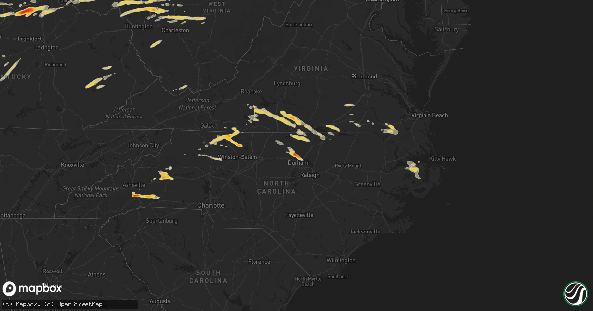
Hail Map on May 1, 2012
Get this storm
May 1 map
$229
one time, instant access
Download today. No call, no setup
Keep the $229
Bought the map and want the full workflow? Apply the entire $229 to a subscription within 7 days. None of it is wasted.
Every map, not just this one
This buys you this map. Subscription and you get every map we run, in the markets you choose from a few cities to whole states to nationwide. Plus real-time alerts the moment a storm fires.
Contact data
Name, contact info, occupancy, even credit band for addresses in the footprint. You go from where it hit to who to call.
Become the source they trust
Unlimited branding weather history reports on demand. You already have the documented answer ready for the property owner, and you are the one who showed up with it.
Property data and RoofTrace estimates
Pull up any address you have got, its value and the exact code rules for that jurisdiction, straight from One Click Code. Then RoofTrace estimates the squares, pitch, and roof value, priced the way you price.
States Impacted by Hail Map on May 1, 2012
Storm reports
Nebraska
| Date | Description |
|---|---|
| 05/01/20126:40 PM CDT | A local report indicates 1.00 inch wind near 4 N ROSE |
| 05/01/20126:13 PM CDT | Quarter to ping pongball sized hail was reported by residents on the south part of town. |
| 05/01/20125:05 PM CDT | A local report indicates 1.50 inch wind near 4 S AINSWORTH |
| 05/01/20124:47 PM CDT | A local report indicates 1.75 inch wind near 4 SW AINSWORTH |
| 05/01/20124:35 PM CDT | Ground covered in hail. |
| 05/01/20121:55 AM CDT | Hail up to 1 inch in diameter in the florence area...near 32nd and tucker. Also had 1.82 rainfall in the last 24 hours. Time estimated. |
| 04/30/201211:00 PM CDT | Delayed report. Hail up to 1.5 inches...most stones smaller. Time estimated from radar. |
| 04/30/201210:43 PM CDT | A local report indicates 1.00 inch wind near BENEDICT |
| 04/30/201210:40 PM CDT | A local report indicates 1.25 inch wind near UTICA |
| 04/30/201210:37 PM CDT | A local report indicates 1.00 inch wind near UTICA |
| 04/30/201210:30 PM CDT | Delayed report. Time estimated from radar. |
| 04/30/201210:15 PM CDT | Delayed report. Nickel to quarter size hail. Time estimated from radar. |
| 04/30/20129:51 PM CDT | A local report indicates 1.50 inch wind near 5 N AURORA |
| 04/30/20129:31 PM CDT | A local report indicates 1.00 inch wind near 5 W AURORA |
| 04/30/20129:29 PM CDT | Estimated winds at 40 mph |
| 04/30/20129:25 PM CDT | Winds estimated at 35 mph. |
North Carolina
| Date | Description |
|---|---|
| 05/01/20126:30 PM CDT | Several trees down across eastern gates county. |
| 05/01/20126:15 PM CDT | *** 1 fatal *** tree down on a vehicle on middle swamp rd |
| 05/01/20125:51 PM CDT | A local report indicates 1.00 inch wind near 1 NNE GORMAN |
| 05/01/20125:45 PM CDT | Trees down south of franklin along general thomas highway and smith ferry road. |
| 05/01/20125:35 PM CDT | Quarter size hail at cabin branch drive and vintage hill parkway |
| 05/01/20125:26 PM CDT | 1.5 inch hail covering the ground near guess road and milton road |
| 05/01/20125:26 PM CDT | Quarter size hail reported at barclay drive and smith drive |
| 05/01/20125:24 PM CDT | 1 inch hail covering the ground at oak forest road dr and guess road. |
| 05/01/20125:18 PM CDT | 2 trees down on reeves mill road. |
| 05/01/20125:18 PM CDT | 2 trees down on hamburg street. |
| 05/01/20125:15 PM CDT | Quarter size hail currently falling in northeast hillsborough. |
| 05/01/20124:55 PM CDT | Observed at buck creek campground. |
| 05/01/20124:37 PM CDT | Trees down on timberline dr. |
| 05/01/20124:27 PM CDT | Numerous trees reported down... Some on homes... Along hickory farm road. |
| 05/01/20124:17 PM CDT | Additional trees down on i-85 just north of welcome center. |
| 05/01/20124:16 PM CDT | Two trees reported down south of the i-85 welcome center toward exit 229. |
| 05/01/20124:12 PM CDT | Employee at courtney elementary school reported quarter size hail |
| 05/01/20124:07 PM CDT | Spotter reported half dollar size hail |
| 05/01/20123:50 PM CDT | Quarter size hail reported at s p gentry store ne of roxboro. |
| 05/01/20123:40 PM CDT | A local report indicates 1.00 inch wind near 4 WSW BETHEL HILL |
| 05/01/20123:35 PM CDT | Small tree split and fell in the brooks crossroads area |
| 05/01/20123:25 PM CDT | Time estimated by radar data. |
| 05/01/20123:12 PM CDT | A local report indicates 1.00 inch wind near 2 S TABLE ROCK |
| 05/01/20123:11 PM CDT | A few quarter size hailstones were mixed in with dime to nickel size hail. |
| 05/01/20123:11 PM CDT | Quarter size hail reported by an ambulance traveling on us route 421 south of ronda |
| 05/01/20123:00 PM CDT | Golf ball size hail |
| 05/01/20122:50 PM CDT | A local report indicates 1.00 inch wind near 5 NNE CASAR |
| 05/01/20122:44 PM CDT | Quarter size hail reported at exit 105 on i-40. |
| 05/01/20122:43 PM CDT | A local report indicates 1.00 inch wind near 4 SE MORGANTON |
| 05/01/20122:40 PM CDT | A local report indicates 1.25 inch wind near 4 S MORGANTON |
| 05/01/20122:33 PM CDT | Observed off of jamestown rd and dixie blvd |
| 05/01/20122:25 PM CDT | Hail damaged parked vehicles. |
| 05/01/20122:25 PM CDT | Golf ball size hail near the intersection of mitchell road and wilson road |
| 05/01/20122:20 PM CDT | Quarter size hail on mcdaniel road just south of westfield |
| 05/01/20122:15 PM CDT | Large branches blown down and blocking road. |
| 05/01/20122:15 PM CDT | Severe hail damage totaled at least one vehicle. Hail fell for a period of 10 minutes. Near the intersection of interstate 26 and highway 25. |
| 05/01/20122:15 PM CDT | A local report indicates 1.00 inch wind near 3 E FLETCHER |
| 05/01/20122:00 PM CDT | Hail reported in the lake james area. |
| 05/01/20121:58 PM CDT | A local report indicates 1.00 inch wind near 5 ESE LAKE LURE |
| 05/01/20121:45 PM CDT | Destroyed crops near highway 9 just south of county line. |
Virginia
| Date | Description |
|---|---|
| 05/01/20126:00 PM CDT | Tree down across n. Liberty spring rd. |
| 05/01/20125:45 PM CDT | Trees down south of franklin along general thomas highway and smith ferry road. |
| 05/01/20125:30 PM CDT | Tree down across road. |
| 05/01/20125:30 PM CDT | Tree was downed blocking storys station road. |
| 05/01/20124:33 PM CDT | Trees down on oak grove rd |
| 05/01/20124:25 PM CDT | Trees down on hendricks mill rd |
| 05/01/20123:10 PM CDT | Multiple trees down on berry hill rd |
| 05/01/20123:10 PM CDT | Multiple trees down on river road |
| 05/01/20123:05 PM CDT | Kennon lane |
| 05/01/20123:00 PM CDT | Mountain road |
| 05/01/20123:00 PM CDT | A local report indicates 1.00 inch wind near HALIFAX |
| 05/01/20122:41 PM CDT | Several large trees blown down on herman farmer road...including a 100 year old oak tree. Report from wset. |
| 05/01/20122:38 PM CDT | Nickel and quarter hail covering the ground at figsboro general store. Time estimated from radar. |
| 05/01/20122:25 PM CDT | Multiple trees down on beverly heights rd |
| 05/01/20121:43 PM CDT | One tree down along route 220 |
| 05/01/20121:40 PM CDT | A local report indicates 1.00 inch wind near 5 SE ROCKY MOUNT |
Kentucky
| Date | Description |
|---|---|
| 05/01/20124:51 PM CDT | A local report indicates 1.00 inch wind near 3 N DRY RIDGE |
| 05/01/20124:33 PM CDT | A local report indicates 2.50 inch wind near 3 SE WARSAW |
| 05/01/20124:17 PM CDT | A local report indicates 2.50 inch wind near 4 W SANDERS |
| 05/01/20124:15 PM CDT | A local report indicates 1.00 inch wind near 3 E CARROLLTON |
| 05/01/20123:50 PM CDT | Damage to a barn and house along abbott lane. |
| 05/01/20123:47 PM CDT | Downburst winds estimated at 75 mph tore off most of the metal roofing of a barn |
| 05/01/20123:45 PM CDT | Weak ef-0 tornado with estimated 65 mph winds did tree damage as it briefly touched down along mount pleseant road northwest of bedford... Snapping upper-level tree bra |
| 05/01/20123:40 PM CDT | Tree down in roadway. |
| 05/01/20123:07 PM CDT | Winds estimated to 40 mph |
| 05/01/20122:59 PM CDT | A local report indicates 1.00 inch wind near 2 N SPRINGFIELD |
| 05/01/20122:36 PM CDT | A local report indicates 1.00 inch wind near CUSTER |
| 05/01/20121:23 PM CDT | A local report indicates 1.00 inch wind near 8 W FORDSVILLE |
| 04/30/20128:47 PM CDT | Quarter sized hail and strong winds were reported. |
| 04/30/20128:47 PM CDT | Quarter size hail reported near royalton on ky 7. Emergency crews reported wind gusts so strong the had to pull the car off of the road. |
Minnesota
| Date | Description |
|---|---|
| 05/01/20126:45 PM CDT | A local report indicates 1.75 inch wind near DUELM |
| 05/01/20126:38 PM CDT | A local report indicates 1.00 inch wind near 2 E ST CLOUD |
| 05/01/20126:34 PM CDT | A local report indicates 64 MPH wind near 4 E SAUK RAPIDS |
| 05/01/20126:29 PM CDT | A local report indicates 1.00 inch wind near 3 NW ST CLOUD |
| 05/01/20126:17 PM CDT | A local report indicates 1.00 inch wind near 1 N SARTELL |
| 05/01/20126:14 PM CDT | A local report indicates 1.75 inch wind near SARTELL |
| 05/01/20126:10 PM CDT | A local report indicates 1.75 inch wind near ST JOSEPH |
| 05/01/20126:07 PM CDT | A local report indicates 1.75 inch wind near ST STEPHEN |
| 05/01/20125:48 PM CDT | Covering ground windshields broken entire city |
| 05/01/20125:46 PM CDT | A local report indicates 1.75 inch wind near ALBANY |
| 05/01/20125:33 PM CDT | A local report indicates 1.00 inch wind near 2 WNW CURRENT LAKE |
| 05/01/20125:30 PM CDT | A local report indicates 1.00 inch wind near 10 N MONTEVIDEO |
| 05/01/20125:30 PM CDT | A local report indicates 1.00 inch wind near 1 W FREEPORT |
| 05/01/20125:30 PM CDT | A local report indicates 1.75 inch wind near FREEPORT |
| 05/01/20125:28 PM CDT | A local report indicates 1.25 inch wind near 4 WSW CURRENT LAKE |
| 05/01/20125:07 PM CDT | A local report indicates a tornado near 3 NE BROOTEN |
| 05/01/20125:01 PM CDT | A local report indicates 1.00 inch wind near 6 E DAWSON |
| 05/01/20124:53 PM CDT | A local report indicates 1.00 inch wind near 4 S SAUK CENTRE |
| 05/01/20124:48 PM CDT | Brief touchdown near sedan |
| 05/01/20124:45 PM CDT | A local report indicates a tornado near 3 W BROOTEN |
| 05/01/20124:37 PM CDT | A local report indicates 1.00 inch wind near 4 SW RUTHTON |
| 05/01/20124:11 PM CDT | A local report indicates 1.00 inch wind near 1 S GLENWOOD |
| 04/30/20127:55 PM CDT | A local report indicates 1.00 inch wind near 2 SSE BEAVER CREEK |
| 04/30/20127:55 PM CDT | A local report indicates 1.00 inch wind near 2 SE BEAVER CREEK |
| 04/30/20127:50 PM CDT | A local report indicates 1.00 inch wind near 2 SSE BEAVER CREEK |
| 04/30/20127:45 PM CDT | Tree blocking road |
| 04/30/20127:42 PM CDT | Delayed report from may 1st. 3 large trees blow over and roof damage noted. |
| 04/30/20127:40 PM CDT | Large branch down on power line |
| 04/30/20127:20 PM CDT | Street lites toppled and large trees took down power poles on east side of city |
| 04/30/20127:20 PM CDT | Tree down on highway 95 |
| 04/30/20127:10 PM CDT | A local report indicates 1.00 inch wind near 2 N WALNUT GROVE |
| 04/30/20127:00 PM CDT | Pea to quarter size hail. |
Illinois
| Date | Description |
|---|---|
| 05/01/20125:20 PM CDT | At eoc |
| 05/01/20125:20 PM CDT | At 14th st and il rt 1. Relayed by ema. |
| 05/01/20125:18 PM CDT | At i-74 and us 150. Relayed by vermilion ema. |
| 05/01/20124:47 PM CDT | Swop report. Relayed by champaign ema. Corrected hail size. |
| 05/01/20124:43 PM CDT | Brief touchdown on west side of sidney. |
| 05/01/20124:32 PM CDT | A local report indicates 1.00 inch wind near ST. JOSEPH |
| 05/01/20124:15 PM CDT | Tornado was on ground for 7 minutes. From piatt co ema. |
| 05/01/20124:15 PM CDT | Tornado in farm field near 900n and 500 e. From piatt co. Ema. |
| 05/01/20124:12 PM CDT | Brief touchdown in farm field. |
| 05/01/20124:09 PM CDT | Brief touchdown in farm field |
| 05/01/20125:01 AM CDT | Mostly penny size hail...time estimated from radar...delayed report. |
Iowa
| Date | Description |
|---|---|
| 05/01/20124:52 AM CDT | Report of a few 2 inch tree limbs down in the city. Time estimated from radar. |
| 05/01/20124:50 AM CDT | Report of several branches down about 6 inches in diameter. Time estimated from radar. |
| 05/01/20124:39 AM CDT | Time estimated from radar. |
| 05/01/20123:35 AM CDT | Large tree blown over near interesection of 51st st and 32nd ave...roof blown off barn...1 grain bin blown out...time estimated from radar. |
| 05/01/20122:40 AM CDT | Large limb toppled a power line which fell across ia-175 in reinbeck. Several other large limbs down across the west side of town. Time estimated from radar. |
| 05/01/20122:23 AM CDT | Emergency manager reported 4 1 1/2 foot diameter evergrren trees downed and a roof torn off a barn nw corner of boone. Also from 1n boone to the eastern border of boone |
| 05/01/20122:16 AM CDT | Several 10-inch limbs down. Time estimated from radar. |
| 05/01/20121:59 AM CDT | The top of a tree two foot in diameter was snapped off in the town of roland. Time estimated from radar. |
| 05/01/20121:55 AM CDT | Wind damage to trees |
| 05/01/20121:53 AM CDT | Power lines reported down in the city of ames. |
| 05/01/20121:52 AM CDT | Pine tree uprooted and multiple tree limbs down. |
| 05/01/20121:52 AM CDT | Measured at the ames mesonet site. |
| 05/01/20121:51 AM CDT | Tree landed on a house and on a car in the area of nixon circle in ames. Additionally...the tree damaged the gas line to the house. Time estimated from radar. |
| 05/01/20121:50 AM CDT | Garage doors blown in with gutters torn off. Apartment complex in north ames. From isu meteorology student. |
| 05/01/20121:50 AM CDT | Damage report within two blocks of bloomington road and grand...shingles off house roofs...privacy fences down..apartment building lost partial balcony...trees of one t |
| 05/01/20121:40 AM CDT | Several large limbs down and damage to fences. Damage began about 1 mile south of fraser and continued sporadically for about the next 2 miles |
| 05/01/20121:36 AM CDT | A local report indicates 1.00 inch wind near 2 SW VOLNEY |
| 05/01/20121:27 AM CDT | Several 6-inch tree limbs down. Time estimated from radar. |
| 04/30/201211:34 PM CDT | Trained spotter reported quarter sized hail blowing vertically against the window. Estimated at least 60 mph wind gusts |
| 04/30/201210:55 PM CDT | Trained spotter driving on highway 15 between whittemore and fenton estimated 60 mph winds and had trouble controlling his car. Reported several cars in the ditch and q |
| 04/30/201210:20 PM CDT | Horizontal rain and numerous 6 inche tree branches down. |
| 04/30/201210:18 PM CDT | Damage to roof. |
| 04/30/201210:06 PM CDT | Measured by rwis. |
| 04/30/20129:56 PM CDT | A local report indicates 60 MPH wind near 3 N ROYAL |
| 04/30/20129:55 PM CDT | Numerous trees down and some windows blown out of buildings. |
| 04/30/20129:44 PM CDT | 70-80 mph wind gust |
| 04/30/20129:40 PM CDT | Several power poles leaning along 130th avenue south of everly. |
| 04/30/20129:40 PM CDT | A local report indicates a tornado near 3 SW EVERLY |
| 04/30/20129:35 PM CDT | A local report indicates 70 MPH wind near 1 S OCHEYEDAN |
| 04/30/20129:20 PM CDT | Numerous 1 to 3 inch diameter tree branches blown down. |
| 04/30/20129:17 PM CDT | Damage to several outbuildings to three farmsteads. Winds estimated between 70 and 85 mph. |
| 04/30/20129:15 PM CDT | A local report indicates 74 MPH wind near SHELDON |
| 04/30/20129:00 PM CDT | Measured by rwis station. |
| 04/30/20128:15 PM CDT | A local report indicates 1.00 inch wind near 5 E ALVORD |
| 04/30/20127:45 PM CDT | Combination of hail and strong winds stripped leaves from trees. |
| 04/30/20127:34 PM CDT | Hail occurred with 50 to 55 mph winds. |
| 04/30/20127:22 PM CDT | A local report indicates 1.50 inch wind near 5 SE CANTON |
South Dakota
| Date | Description |
|---|---|
| 05/01/20126:40 PM CDT | Lots of branches down |
| 05/01/20126:35 PM CDT | A local report indicates 60 MPH wind near 3 W HUMBOLDT |
| 05/01/20125:36 PM CDT | A local report indicates 1.00 inch wind near 7 S MITCHELL |
| 05/01/20124:45 PM CDT | Up to one inch hail covered the ground. |
| 05/01/20124:20 PM CDT | Ground is covered in hail drifts |
| 05/01/20124:15 PM CDT | Hail covered ground and drifted. Still piles left the next morning. Also heavy rain which measured 2.04 inches. No hail 1 mile north of this location. |
| 05/01/20124:10 PM CDT | A local report indicates 1.00 inch wind near 9 N BRIDGEWATER |
| 05/01/20124:10 PM CDT | A local report indicates 1.25 inch wind near NNW EMERY |
| 05/01/20124:05 PM CDT | A local report indicates 1.00 inch wind near 2 W SALEM |
| 04/30/20128:55 PM CDT | A local report indicates 63 MPH wind near PHILIP |
North Dakota
| Date | Description |
|---|---|
| 05/01/20126:25 PM CDT | Very heavy rains and lots of dime to quarter sized hail fell over a five minute period... Until about 630 pm cdt. |
| 05/01/20125:35 PM CDT | Numerous dime to quarter sized hail. Hail nearly covered the round. |
West Virginia
| Date | Description |
|---|---|
| 04/30/20127:45 PM CDT | Se of patriot |
Ohio
| Date | Description |
|---|---|
| 05/01/20126:57 PM CDT | Tree fell on roof of house. |
| 05/01/20126:56 PM CDT | A local report indicates 1.25 inch wind near SOUTH WEBSTER |
| 05/01/20126:45 PM CDT | Several trees down |
| 05/01/20126:40 PM CDT | 6 trees down across roads |
| 05/01/20126:25 PM CDT | Trees down on marble furnace road. |
| 05/01/20126:20 PM CDT | A local report indicates 1.75 inch wind near 5 NW WAVERLY |
| 05/01/20126:06 PM CDT | 1 tree down on marshall point road. |
| 05/01/20126:02 PM CDT | Home with minor damage |
| 05/01/20126:00 PM CDT | A local report indicates 1.00 inch wind near CHILLICOTHE |
| 05/01/20125:49 PM CDT | A local report indicates 1.75 inch wind near CHILLICOTHE |
| 05/01/20125:47 PM CDT | Tree down across the road. |
| 05/01/20125:25 PM CDT | A local report indicates 1.00 inch wind near BATAVIA |
| 05/01/20125:24 PM CDT | Nws survey confirms brief ef0 tornado with minor tree and structural damage |
| 05/01/20125:24 PM CDT | A local report indicates 1.00 inch wind near 1 W WILMINGTON |
| 05/01/20125:20 PM CDT | Nws storm survey confirms brief ef0 tornado with minor damage to a structure and automobile |
| 05/01/20125:06 PM CDT | Hail damage to cars. |
| 05/01/20124:55 PM CDT | A local report indicates 1.75 inch wind near DEER PARK |
| 05/01/20124:44 PM CDT | A local report indicates 1.00 inch wind near 3 NW ARCANUM |
| 05/01/20124:39 PM CDT | A local report indicates 1.00 inch wind near WYOMING |
| 05/01/20124:35 PM CDT | A local report indicates 1.75 inch wind near 3 W ARCANUM |
| 05/01/20124:32 PM CDT | A local report indicates 1.00 inch wind near DENT |
| 05/01/20124:30 PM CDT | A local report indicates 1.00 inch wind near WHITE OAK |
| 05/01/20124:29 PM CDT | A local report indicates 1.75 inch wind near WHITE OAK |
| 05/01/20124:29 PM CDT | Several trees down. |
| 05/01/20124:27 PM CDT | A local report indicates 1.75 inch wind near CINCINNATI |
| 05/01/20124:00 AM CDT | 12 inch diameter tree down across u.s. Highway 40 and chapel hill rd. Delayed report from this morning. |
| 04/30/20128:48 PM CDT | Trees down. No indication of tree size. |
| 04/30/20128:10 PM CDT | 1 tree down across sr 144 north of coolville |
| 04/30/20127:50 PM CDT | Public sent picture of golfball size hail to the media. |
| 04/30/20127:50 PM CDT | Public sent picture of golfball size hail to the media. |
| 04/30/20127:45 PM CDT | Power line down in syracuse. |
| 04/30/20127:42 PM CDT | Trees down in vinton on union ridge rd. Limbs 4 in in diameter... Trunk approx. 12 in. |
| 04/30/20127:40 PM CDT | 1 tree down across long fellow rd. North of pomeroy. |
| 04/30/20127:40 PM CDT | 1 tree down along sr 143 east of carpenter |
| 04/30/20127:40 PM CDT | 1 tree and powerline down across setty rd. |
| 04/30/20127:40 PM CDT | Public sent picture of golfball size hail to the media. |
| 04/30/20127:20 PM CDT | Report of multiple trees down along union ridge/cr 6. |
| 04/30/20127:15 PM CDT | Powerline down in coalton |
Indiana
| Date | Description |
|---|---|
| 05/01/20126:37 PM CDT | Hit a house and destroyed a barn |
| 05/01/20126:36 PM CDT | Tornado moving east |
| 05/01/20126:29 PM CDT | A local report indicates 1.25 inch wind near PLAINFIELD |
| 05/01/20126:25 PM CDT | A local report indicates 1.00 inch wind near PLAINFIELD |
| 05/01/20126:13 PM CDT | A local report indicates 1.00 inch wind near WHEATLAND |
| 05/01/20126:08 PM CDT | A local report indicates 1.00 inch wind near 7 S SPENCER |
| 05/01/20126:07 PM CDT | A local report indicates 1.00 inch wind near MONROE CITY |
| 05/01/20125:57 PM CDT | A local report indicates a tornado near 2 E YEDDO |
| 05/01/20125:50 PM CDT | A local report indicates 1.00 inch wind near VEEDERSBURG |
| 05/01/20125:41 PM CDT | A local report indicates 1.00 inch wind near 4 S COVINGTON |
| 05/01/20125:31 PM CDT | A local report indicates 1.00 inch wind near 5 W COVINGTON |
| 05/01/20125:28 PM CDT | A local report indicates 60 MPH wind near GREENSBURG |
| 05/01/20125:02 PM CDT | A local report indicates 1.00 inch wind near 3 W CROTHERSVILLE |
| 05/01/20124:50 PM CDT | A local report indicates 70 MPH wind near LAWRENCEBURG |
| 05/01/20124:20 PM CDT | Nws storm survey confirms ef1 tornado with path length of 1.3 miles. Damage to trees...farm outbuildings...and grain bins. |
| 05/01/20124:15 PM CDT | Possible tornado damaged grain bins...sheds and trees. |
| 05/01/20124:10 PM CDT | A local report indicates 1.00 inch wind near BRIGHT |
| 05/01/20124:03 PM CDT | A local report indicates 1.00 inch wind near GUILFORD |
| 05/01/20123:59 PM CDT | A local report indicates 1.00 inch wind near 5 NW LAWRENCEBURG |
| 05/01/20123:56 PM CDT | A local report indicates 58 MPH wind near STRAUGHN |
| 05/01/20123:49 PM CDT | A local report indicates 70 MPH wind near SULPHUR SPRINGS |
| 05/01/20123:43 PM CDT | A local report indicates 1.00 inch wind near SUNMAN |
| 05/01/20123:27 PM CDT | Semi trailer blown over |
| 05/01/20123:27 PM CDT | A local report indicates 60 MPH wind near GREENSBURG |
| 05/01/20123:23 PM CDT | A local report indicates 1.00 inch wind near MILFORD |
| 05/01/20123:23 PM CDT | A local report indicates 78 MPH wind near MILFORD |
| 05/01/20123:00 PM CDT | A local report indicates 59 MPH wind near 5 W GREENWOOD |
| 05/01/20122:53 PM CDT | Brief touchdown reported west side of columbus |
| 05/01/20122:53 PM CDT | Trees reported down |
| 05/01/20122:50 PM CDT | Quarter hail in northwest columbus on lowell road just west of us 31. |
| 05/01/20122:47 PM CDT | A local report indicates 1.00 inch wind near NASHVILLE |
| 05/01/20122:00 PM CDT | Isolated reports of trees down in the ellettsville area |
| 04/30/20127:20 PM CDT | A local report indicates 1.50 inch wind near NASHVILLE |
| 04/30/20127:04 PM CDT | A local report indicates 1.50 inch wind near UNIONVILLE |
Cities Impacted by Hail Map on May 1, 2012
- Pinnacle, NC
- Cylinder, IA
- Comfrey, MN
- Pilot Mountain, NC
- Stuart, VA
- Lawsonville, NC
- Germanton, NC
- Mount Airy, NC
- Dobson, NC
- Westfield, NC
- King, NC
- State Road, NC
- Walnut Cove, NC
- Elkin, NC
- Ararat, NC
- Geddes, SD
- Bedford, KY
- Hanover, IN
- Nabb, IN
- Milton, KY
- Bethlehem, IN
- Corsica, SD
- Letts, IA
- Columbus Junction, IA
- Conesville, IA
- Gallipolis, OH
- Crown City, OH
- Patriot, OH
- Saint Peter, MN
- Sioux Rapids, IA
- Creston, NE
- Leigh, NE
- Humphrey, NE
- Long Grove, IA
- Capron, VA
- Colman, SD
- Egan, SD
- Nathalie, VA
- Java, VA
- South Boston, VA
- Vernon Hill, VA
- Halifax, VA
- Gretna, VA
- Vinton, OH
- Langsville, OH
- Leon, WV
- Sutherland, IA
- Bloomington, IN
- Loveland, OH
- Milford, OH
- Goshen, OH
- Garvin, MN
- Walnut Grove, MN
- Ruthton, MN
- Slayton, MN
- Marshall, MN
- Russell, MN
- Tracy, MN
- Balaton, MN
- Woodstock, MN
- Holland, MN
- Tyler, MN
- Currie, MN
- Chandler, MN
- Iona, MN
- Lake Wilson, MN
- Durham, NC
- Hillsborough, NC
- Rougemont, NC
- Hurdle Mills, NC
- Bahama, NC
- Hendersonville, NC
- Fletcher, NC
- Horse Shoe, NC
- Mills River, NC
- Herington, KS
- Edinburg, ND
- Hoople, ND
- Crystal, ND
- Duck, WV
- Spencer, IN
- Unionville, IN
- Ellettsville, IN
- Danville, IN
- Plainfield, IN
- Reelsville, IN
- Cloverdale, IN
- Greencastle, IN
- Rock Rapids, IA
- Doon, IA
- George, IA
- Ashland, NE
- Yutan, NE
- Waterloo, NE
- Gretna, NE
- Greenwood, NE
- Ithaca, NE
- Memphis, NE
- Sardinia, OH
- Georgetown, OH
- Russellville, OH
- Gallipolis Ferry, WV
- Apple Grove, WV
- Larchwood, IA
- Inwood, IA
- Little Rock, IA
- Ashton, IA
- Melvin, IA
- Sibley, IA
- Ocheyedan, IA
- Hills, MN
- Chillicothe, OH
- Canton, SD
- Alvord, IA
- Fairview, SD
- Hudson, SD
- Rock Valley, IA
- Belgrade, MN
- Saint Joseph, MN
- Sauk Rapids, MN
- Elrosa, MN
- Brooten, MN
- Waite Park, MN
- Freeport, MN
- Villard, MN
- Sauk Centre, MN
- Avon, MN
- Saint Cloud, MN
- Glenwood, MN
- Albany, MN
- Melrose, MN
- Foley, MN
- Sartell, MN
- Rushville, IN
- Laurel, IN
- Lehigh, IA
- Dayton, IA
- Stratford, IA
- Sleepy Eye, MN
- Burdick, KS
- Lost Springs, KS
- White City, KS
- Wheelersburg, OH
- Portsmouth, OH
- Oak Hill, OH
- Cheshire, OH
- Minford, OH
- Letart, WV
- Point Pleasant, WV
- West Columbia, WV
- Cottageville, WV
- Henderson, WV
- Bidwell, OH
- South Webster, OH
- Racine, OH
- Thurman, OH
- Mount Alto, WV
- Millwood, WV
- Coxs Creek, KY
- Baskerville, VA
- Ebony, VA
- South Hill, VA
- Bracey, VA
- La Crosse, VA
- Bainbridge, IN
- Worthville, KY
- Ghent, KY
- Sparta, KY
- Jonesville, KY
- Turners Station, KY
- Sanders, KY
- Glencoe, KY
- Dry Ridge, KY
- Carrollton, KY
- Omaha, NE
- Crescent, IA
- McClelland, IA
- Minden, IA
- Underwood, IA
- Council Bluffs, IA
- Ainsworth, NE
- Long Pine, NE
- Johnstown, NE
- Sioux Center, IA
- Bruce, SD
- Saint Stephen, MN
- Royalton, MN
- Clear Lake, MN
- Rice, MN
- Oak Park, MN
- Starbuck, MN
- Holdingford, MN
- Bowlus, MN
- Dry Fork, VA
- Chatham, VA
- Union Hall, VA
- Penhook, VA
- Rocky Mount, VA
- Glade Hill, VA
- Sutherlin, VA
- Blairs, VA
- Callands, VA
- Alton, VA
- Keeling, VA
- Morganton, NC
- Marion, NC
- Nebo, NC
- Delmont, SD
- Blanchester, OH
- Pleasant Plain, OH
- Morrow, OH
- Columbia, NC
- Morristown, IN
- Lynchburg, OH
- Fayetteville, OH
- Hillsboro, OH
- Mount Orab, OH
- Alta Vista, KS
- Dwight, KS
- Junction City, KS
- Phillips, NE
- Marquette, NE
- Aurora, NE
- Winona, MN
- Minnesota City, MN
- Pender, NE
- Bethany, MO
- Albany, MO
- New Hampton, MO
- Martinsville, MO
- Richmond, MN
- Springfield, KY
- Clearwater, MN
- Monticello, MN
- Becker, MN
- Murdock, MN
- Sunburg, MN
- Edgerton, MN
- Martinsville, IN
- Aurora, IN
- Moores Hill, IN
- Lawrenceburg, IN
- Neola, IA
- Oakland, IA
- Warwick, ND
- Crary, ND
- Lakota, ND
- Salem, SD
- Bridgewater, SD
- Emery, SD
- Madison, SD
- Spencer, SD
- Canistota, SD
- Winfred, SD
- Colton, SD
- Montrose, SD
- Chester, SD
- Greenville, MI
- Booneville, KY
- Ricetown, KY
- Buckhorn, KY
- Jackson, KY
- Catlin, IL
- Tilton, IL
- Danville, IL
- Covington, IN
- Westville, IL
- Perrysville, IN
- Breda, IA
- Ramona, SD
- Langdon, ND
- Wales, ND
- Hannah, ND
- Springfield, OH
- Raywick, KY
- Loretto, KY
- Lebanon, KY
- Saint Catharine, KY
- Heron Lake, MN
- Vevay, IN
- Gowrie, IA
- Paton, IA
- Elizabethtown, KY
- Lebanon Junction, KY
- West Point, KY
- Hazel Green, WI
- Cuba City, WI
- Batesville, IN
- Osgood, IN
- Greensburg, IN
- Wentworth, SD
- Doniphan, NE
- Okabena, MN
- Lakefield, MN
- Cincinnati, OH
- Oxford, NC
- Roxboro, NC
- York, NE
- McCool Junction, NE
- Marion, SD
- Fort Dodge, IA
- Frankfort, OH
- Greenfield, OH
- Franklin Furnace, OH
- Willow Wood, OH
- Pedro, OH
- Southside, WV
- Fraziers Bottom, WV
- Ironton, OH
- Scottown, OH
- Waterloo, OH
- Ethan, SD
- Mitchell, SD
- Jasper, MN
- Hardwick, MN
- Olivet, SD
- Kimball, MN
- South Haven, MN
- Ivydale, WV
- Wallback, WV
- Clay, WV
- Benedict, NE
- Bradshaw, NE
- Union, KY
- Hebron, KY
- Burlington, KY
- Persia, IA
- Piketon, OH
- Waverly, OH
- Trent, SD
- Pipestone, MN
- Flandreau, SD
- Pollock, MO
- Milan, MO
- Arlington, SD
- Volga, SD
- Foreston, MN
- Milaca, MN
- Clayton, IN
- Coatesville, IN
- Stilesville, IN
- Prague, NE
- Linwood, NE
- Bruno, NE
- Abie, NE
- Luverne, MN
- Whitesville, KY
- Harts, WV
- Spurlockville, WV
- Alkol, WV
- McKenney, VA
- Belmond, IA
- Clarion, IA
- Rowan, IA
- Bennington, NE
- Hartley, IA
- Sanborn, IA
- Primghar, IA
- Harris, IA
- Milford, IA
- Lake Park, IA
- Everly, IA
- Bardstown, KY
- Jackson, OH
- Latham, OH
- Albany, OH
- Hamden, OH
- West Union, OH
- Seaman, OH
- South Salem, OH
- Bainbridge, OH
- Ray, OH
- Winchester, OH
- Blue Creek, OH
- Beaver, OH
- McArthur, OH
- Ripley, OH
- Peebles, OH
- Londonderry, OH
- Wellston, OH
- Otway, OH
- Lucasville, OH
- Rarden, OH
- McDermott, OH
- Fairland, IN
- Arlington, IN
- Shelbyville, IN
- Manilla, IN
- Austin, IN
- Deputy, IN
- Crothersville, IN
- Scottsburg, IN
- Paris Crossing, IN
- Brownstown, IN
- Vallonia, IN
- Granger, IA
- Woodward, IA
- Manchester, IA
- Rockville, IN
- Brazil, IN
- Hamilton, OH
- Charleston, WV
- Tolna, ND
- Arcanum, OH
- Greenville, OH
- Mason, OH
- Gosport, IN
- Nashville, IN
- Alexandria, SD
- Jamestown, IN
- Thorntown, IN
- Argyle, WI
- Mineral Point, WI
- Blanchardville, WI
- Darlington, WI
- Camby, IN
- Bee, NE
- Seward, NE
- Staplehurst, NE
- Webster, IA
- Keswick, IA
- Seymour, IN
- North Vernon, IN
- Commiskey, IN
- Fulton, SD
- Campbellsburg, IN
- Bedford, IN
- Orleans, IN
- Mitchell, IN
- Mill Spring, NC
- Rutherfordton, NC
- Lake Lure, NC
- Bingham Lake, MN
- Mountain Lake, MN
- Cleves, OH
- Addyston, OH
- North Bend, OH
- Lexington, IN
- Maynard, MN
- Montevideo, MN
- Burke, SD
- Cavalier, ND
- Hensel, ND
- Clarksville, VA
- Bloomfield, IN
- Morris, MN
- Valley Springs, SD
- Beaver Creek, MN
- Princeton, MN
- Springfield, MN
- Sanborn, MN
- Falls Of Rough, KY
- Utica, NE
- Waco, NE
- Martinsville, VA
- David City, NE
- Rising City, NE
- Ridgeway, MO
- Deep River, IA
- Buffalo, WV
- Greenup, KY
- New Madison, OH
- Radcliff, KY
- Rineyville, KY
- Fort Knox, KY
- Vine Grove, KY
- Guilford, IN
- Sunman, IN
- West Harrison, IN
- Milan, IN
- Harrison, OH
- Nelson, VA
- Buffalo Junction, VA
- Virgilina, VA
- Solsberry, IN
- Middletown, OH
- Topeka, KS
- Indianapolis, IN
- Mooresville, IN
- Verona, KY
- Warsaw, KY
- Patriot, IN
- Stromsburg, NE
- Shelby, IA
- Otisco, IN
- Marysville, IN
- Henryville, IN
- Creswell, NC
- Spencer, IA
- Ripley, WV
- Gay, WV
- Suffolk, VA
- Franklin, VA
- Osceola, NE
- Shelby, NE
- Polk, NE
- Rutland, OH
- Roaring River, NC
- North Wilkesboro, NC
- Ronda, NC
- Walhalla, ND
- Anawalt, WV
- Welch, WV
- Evans, WV
- Eldora, IA
- Humboldt, SD
- Hartford, SD
- Estelline, SD
- Walton, WV
- Gandeeville, WV
- Canova, SD
- Mocksville, NC
- Yadkinville, NC
- Hamptonville, NC
- Harmony, NC
- Columbus, IN
- Hartsville, IN
- Arden, NC
- Papillion, NE
- Springfield, NE
- Stanleytown, VA
- Bassett, VA
- Collinsville, VA
- Fieldale, VA
- Carter Lake, IA
- Honey Creek, IA
- Elkhorn, NE
- Boys Town, NE
- Valley, NE
- Herrick, SD
- Wall, SD
- Quinn, SD
- Philip, SD
- Scotland, IN
- Newberry, IN
- Crane, IN
- Avoca, IN
- Odon, IN
- Owensburg, IN
- Springville, IN
- Stanchfield, MN
- Cambridge, MN
- Okeana, OH
- Fairfield, OH
- North English, IA
- Parnell, IA
- Milan, MN
- Watson, MN
- Reedy, WV
- Spencer, WV
- Hornick, IA
- Rodney, IA
- Saint Paul, IN
- Milroy, IN
- Morgantown, IN
- Nineveh, IN
- Hope, IN
- Taylorsville, IN
- Flat Rock, IN
- Edinburgh, IN
- Missouri Valley, IA
- Modale, IA
- Logan, IA
- Arlington, NE
- Blair, NE
- Kennard, NE
- Palestine, OH
- Eldorado, OH
- West Manchester, OH
- Bradford, OH
- Richmond, IN
- Lewisburg, OH
- New Paris, OH
- Henderson, NC
- Bullock, NC
- Callaway, VA
- Ceresco, NE
- Valparaiso, NE
- Davey, NE
- Gresham, NE
- Malcolm, NE
- Garland, NE
- Raymond, NE
- Roscoe, MN
- Paynesville, MN
- Roper, NC
- Redwood Falls, MN
- New Boston, IL
- Lake Andes, SD
- Armour, SD
- Pierz, MN
- Holton, IN
- Miamiville, OH
- Petersburg, KY
- West Chester, OH
- Camp Dennison, OH
- Batavia, OH
- Schuyler, NE
- Latonia, KY
- Newport, KY
- Melbourne, KY
- Silver Grove, KY
- Sarles, ND
- New Ulm, MN
- Morgan, MN
- Wellman, IA
- Ivesdale, IL
- Fithian, IL
- Oakwood, IL
- Veedersburg, IN
- Fairmount, IL
- Ranger, WV
- Bassett, NE
- Eagle Grove, IA
- Homer, IL
- Ogden, IL
- Red House, WV
- Copper Hill, VA
- Avoca, IA
- Poca, WV
- South English, IA
- Osage, IA
- Urbana, IL
- Sidney, IL
- Saint Joseph, IL
- Fillmore, IN
- Salyersville, KY
- Procious, WV
- Newton, WV
- Dimock, SD
- Parkston, SD
- Liberty, WV
- Mapleton, IA
- Ute, IA
- Ames, NE
- Fremont, NE
- Nickerson, NE
- Hooper, NE
- North Bend, NE
- New Palestine, IN
- Pekin, IN
- Summersville, KY
- Greensburg, KY
- Leesburg, OH
- Sabina, OH
- Washington Court House, OH
- Springville, IA
- Anamosa, IA
- Hays, NC
- New Washington, IN
- New Windsor, IL
- Grafton, ND
- Stephen, MN
- Aledo, IL
- Joy, IL
- Waverly, NE
- Wahoo, NE
- Hancock, IA
- Washington, NE
- Fort Calhoun, NE
- Amma, WV
- Kenna, WV
- Clendenin, WV
- Elkview, WV
- Arvilla, ND
- Larimore, ND
- Rowdy, KY
- Chavies, KY
- Krypton, KY
- Hazard, KY
- Sadorus, IL
- Tolono, IL
- Crawfordsville, IN
- Hillsboro, IN
- Darlington, IN
- Waynetown, IN
- Vincennes, IN
- Emporia, VA
- Freeman, VA
- Vinton, IA
- Claudville, VA
- Seymour, WI
- McFall, MO
- Vail, IA
- Guernsey, IA
- Victor, IA
- Coffey, MO
- Pattonsburg, MO
- Hordville, NE
- Hampton, NE
- Carroll, IA
- Whick, KY
- Mistletoe, KY
- Gays Creek, KY
- Lost Creek, KY
- Clayhole, KY
- Salem, IN
- Peterson, IA
- Mead, NE
- Colon, NE
- Benson, MN
- Danvers, MN
- Charter Oak, IA
- Schleswig, IA
- Ricketts, IA
- Deloit, IA
- Denison, IA
- Soldier, IA
- Kiron, IA
- Castana, IA
- Battle Creek, IA
- Middleport, OH
- Hillsboro, WI
- Circleville, OH
- Muncie, IL
- Philo, IL
- Carthage, IN
- Bellevue, IA
- Galena, IL
- Plainville, IN
- Bicknell, IN
- Washington, IN
- Edwardsport, IN
- Henry, VA
- Lewiston, MN
- Alpha, IL
- North Henderson, IL
- Alexis, IL
- Rio, IL
- Borden, IN
- Williamstown, KY
- Falmouth, KY
- West Portsmouth, OH
- Ravenswood, WV
- Pomeroy, OH
- Archer, IA
- Hull, IA
- Sheldon, IA
- Boyden, IA
- Alcester, SD
- Beresford, SD
- Steen, MN
- Hawarden, IA
- Matlock, IA
- Lyndon Station, WI
- New Ross, IN
- Savoy, IL
- Franklin, IN
- Laura, OH
- Ludlow Falls, OH
- Semora, NC
- Columbus, NE
- Platte Center, NE
- Rockford, IA
- Dougherty, IA
- Lewis, IA
- Griswold, IA
- Potosi, WI
- Dickeyville, WI
- Montgomery, IN
- Loogootee, IN
- Tecumseh, KS
- Cold Spring, MN
- Dayton, KY
- Owenton, KY
- Granite Falls, MN
- Como, NC
- Gates, NC
- Corapeake, NC
- Butterfield, MN
- Henderson, NE
- Ulysses, NE
- Scottsburg, VA
- Manson, NC
- Gratiot, WI
- South Wayne, WI
- Brodnax, VA
- Shade, OH
- Athens, OH
- Garnavillo, IA
- Farmersburg, IA
- Wheatland, IN
- Trenton, OH
- Franklin, OH
- Custer, KY
- Ekron, KY
- Hardinsburg, KY
- Westview, KY
- Guston, KY
- Harned, KY
- Irvington, KY
- Garfield, KY
- Shepherdsville, KY
- Iowa Falls, IA
- Isanti, MN
- Independence, IA
- Cedar Grove, NC
- Timberlake, NC
- Urbana, OH
- Saint Paris, OH
- Ainsworth, IA
- Washington, IA
- Zimmerman, MN
- Elk River, MN
- Big Lake, MN
- Underwood, IN
- Lamberton, MN
- Revere, MN
- Salix, IA
- Sloan, IA
- Malcom, IA
- Grinnell, IA
- Hartford, KY
- Monroe City, IN
- Imperial, TX
- Hatfield, MO
- Drayton, ND
- Fairview, NC
- Fordsville, KY
- Reynolds Station, KY
- Kalona, IA
- Terrace Park, OH
- Covington, KY
- Bellevue, KY
- Fort Thomas, KY
- Brookings, SD
- Windom, MN
- Holy Cross, IA
- McGregor, IA
- Sabula, IA
- Clinton, IA
- De Witt, IA
- Delmar, IA
- Warrenton, NC
- Freeman, SD
- Fairmont, MN
- Granada, MN
- Tripp, SD
- Sod, WV
- Sumerco, WV
- Union Grove, NC
- Wilkesboro, NC
- Round Lake, MN
- Worthington, MN
- Maineville, OH
- Seaton, IL
- Keithsburg, IL
- Mebane, NC
- Yanceyville, NC
- Burlington, NC
- Harrodsburg, KY
- Willisburg, KY
- Dell Rapids, SD
- Harrison, SD
- Amelia, OH
- Collettsville, NC
- Lenoir, NC
- Sutton, NE
- Saronville, NE
- Grafton, NE
- Harvard, NE
- Masonville, IA
- Campbellsville, KY
- Glenwood, WV
- Ashton, WV
- Lesage, WV
- Crittenden, KY
- New Liberty, KY
- Grant City, MO
- Dillsboro, IN
- Fountaintown, IN
- Jackson, WI
- Eagleville, MO
- Lecompton, KS
- Dunkerton, IA
- Denver, IA
- Readlyn, IA
- Arcadia, IA
- Portsmouth, IA
- Steamboat Rock, IA
- Whiteland, IN
- Greenwood, IN
- Needham, IN
- Boggstown, IN
- Wasta, SD
- New Underwood, SD
- Owanka, SD
- Muscatine, IA
- De Mossville, KY
- Campbellsburg, KY
- Newport, NE
- Odin, MN
- Trimont, MN
- Morse Bluff, NE
- Michigan, ND
- Elnora, IN
- Luana, IA
- Postville, IA
- Elgin, IA
- Monona, IA
- Central City, IA
- Warfield, VA
- Bancroft, IA
- Whittemore, IA
- Harris, MN
- North Branch, MN
- Grandy, MN
- Lake View, IA
- Wall Lake, IA
- Odebolt, IA
- Switchback, WV
- Maybeury, WV
- Northfork, WV
- Sheffield, IA
- Greenville, IN
- Taunton, MN
- Minneota, MN
- Boyd, MN
- Williamsburg, OH
- Platte, SD
- Winnebago, MN
- Blue Earth, MN
- Stanberry, MO
- Madison, IN
- Walnut, IA
- Monticello, IA
- Hopkinton, IA
- Earlville, IA
- Dyersville, IA
- Delhi, IA
- Butlerville, IN
- Williamsport, OH
- Wilsey, KS
- Ceylon, MN
- Sandborn, IN
- Westphalia, IN
- Versailles, IN
- Glenwood, IN
- Bargersville, IN
- Waldron, IN
- Trafalgar, IN
- New Trenton, IN
- Metamora, IN
- Clifford, IN
- Connersville, IN
- Napoleon, IN
- Ft Mitchell, KY
- Hooven, OH
- Cedar Grove, IN
- Westport, IN
- Brookville, IN
- Oldenburg, IN
- Malmo, NE
- Alexandria, KY
- Independence, KY
- Walton, KY
- Morning View, KY
- Butler, KY
- Brooksville, KY
- Foster, KY
- Seven Mile, OH
- Monroe, OH
- Lebanon, OH
- Norlina, NC
- Macon, NC
- Canby, MN
- Bennett, IA
- Lynn, IN
- Union City, IN
- Olin, IA
- Algona, IA
- Wapello, IA
- Clarkfield, MN
- Hendricks, MN
- Shoals, IN
- Williams, IN
- Delavan, MN
- Skippers, VA
- Ferguson, NC
- Canaan, IN
- Bennington, IN
- Lake City, IA
- Lohrville, IA
- Churdan, IA
- Hamersville, OH
- Felicity, OH
- Traer, IA
- Winnebago, NE
- Macy, NE
- Boones Mill, VA
- Shullsburg, WI
- Leota, MN
- Traphill, NC
- Stanley, IA
- La Motte, IA
- Maquoketa, IA
- Vesta, MN
- Wabasso, MN
- Scales Mound, IL
- Harlan, IA
- Howard, SD
- Hixton, WI
- Pleasantville, IA
- Champaign, IL
- Bethel, OH
- Harris, MO
- Galt, MO
- Waynesville, OH
- Springboro, OH
- Duncombe, IA
- Otho, IA
- Harcourt, IA
- Burnside, IA
- Dewitt, VA
- Lucan, MN
- Cedar Bluffs, NE
- Howells, NE
- Clarkson, NE
- Tipton, IA
- Brayton, IA
- Granville, IA
- Hospers, IA
- Scottsville, KY
- Wilkesville, OH
- Meadows Of Dan, VA
- Ararat, VA
- Dawson, MN
- Old Fort, NC
- Milroy, MN
- Aurora, IA
- Mount Vernon, SD
- Paullina, IA
- Monroe, SD
- Putnamville, IN
- West Newton, IN
- Avon, IN
- Beech Grove, IN
- Brooklyn, IN
- Monrovia, IN
- Siloam, NC
- Bagley, WI
- Sandy Ridge, NC
- Roachdale, IN
- Westside, IA
- Oldham, SD
- Early, IA
- Linn Grove, IA
- Sugar Grove, OH
- Lancaster, OH
- Reeseville, WI
- Madrid, IA
- Illinois City, IL
- Fruitland, IA
- Reynolds, IL
- War, WV
- Berwind, WV
- Clay Center, NE
- Pilger, NE
- Wisner, NE
- Stanton, NE
- Newsoms, VA
- Ellsworth, MN
- Adrian, MN
- Verona, OH
- Brookville, OH
- Advent, WV
- Eleanor, WV
- Winfield, WV
- Hurricane, WV
- Milton, WV
- Cedar Falls, IA
- Janesville, IA
- Waterloo, IA
- Bath, IN
- Oxford, OH
- Watkins, MN
- Viola, IL
- Pittsboro, IN
- North Salem, IN
- Brownsburg, IN
- Thurston, NE
- Walthill, NE
- Whiting, IA
- Mountain, ND
- Pella, IA
- Emmetsburg, IA
- Ayrshire, IA
- Ruthven, IA
- New Vienna, IA
- Erlanger, KY
- Coon Rapids, IA
- Audubon, IA
- Guthrie Center, IA
- Webster City, IA
- Hamlin, IA
- Wood Lake, NE
- Lancaster, WI
- Panama, IA
- White, SD
- Thompson, ND
- Griffithsville, WV
- Giltner, NE
- Florence, IN
- Ormsby, MN
- Holland, IA
- Grundy Center, IA
- Wellsburg, IA