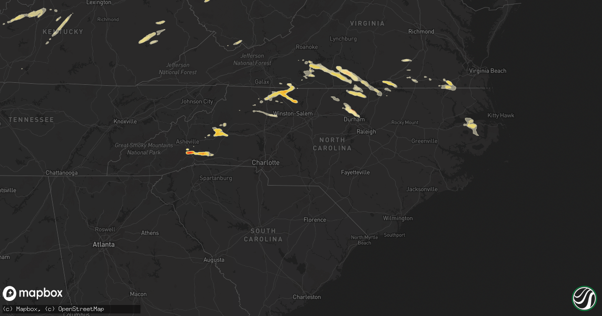
Hail Map in North Carolina on May 1, 2012
Get this storm
May 1 map
$229
one time, instant access
Download today. No call, no setup
Keep the $229
Bought the map and want the full workflow? Apply the entire $229 to a subscription within 7 days. None of it is wasted.
Every map, not just this one
This buys you this map. Subscription and you get every map we run, in the markets you choose from a few cities to whole states to nationwide. Plus real-time alerts the moment a storm fires.
Contact data
Name, contact info, occupancy, even credit band for addresses in the footprint. You go from where it hit to who to call.
Become the source they trust
Unlimited branding weather history reports on demand. You already have the documented answer ready for the property owner, and you are the one who showed up with it.
Property data and RoofTrace estimates
Pull up any address you have got, its value and the exact code rules for that jurisdiction, straight from One Click Code. Then RoofTrace estimates the squares, pitch, and roof value, priced the way you price.
Storm reports in North Carolina
North Carolina
| Date | Description |
|---|---|
| 05/01/20126:30 PM CDT | Several trees down across eastern gates county. |
| 05/01/20126:15 PM CDT | *** 1 fatal *** tree down on a vehicle on middle swamp rd |
| 05/01/20125:51 PM CDT | A local report indicates 1.00 inch wind near 1 NNE GORMAN |
| 05/01/20125:45 PM CDT | Trees down south of franklin along general thomas highway and smith ferry road. |
| 05/01/20125:35 PM CDT | Quarter size hail at cabin branch drive and vintage hill parkway |
| 05/01/20125:26 PM CDT | Quarter size hail reported at barclay drive and smith drive |
| 05/01/20125:26 PM CDT | 1.5 inch hail covering the ground near guess road and milton road |
| 05/01/20125:24 PM CDT | 1 inch hail covering the ground at oak forest road dr and guess road. |
| 05/01/20125:18 PM CDT | 2 trees down on hamburg street. |
| 05/01/20125:18 PM CDT | 2 trees down on reeves mill road. |
| 05/01/20125:15 PM CDT | Quarter size hail currently falling in northeast hillsborough. |
| 05/01/20124:55 PM CDT | Observed at buck creek campground. |
| 05/01/20124:37 PM CDT | Trees down on timberline dr. |
| 05/01/20124:27 PM CDT | Numerous trees reported down... Some on homes... Along hickory farm road. |
| 05/01/20124:17 PM CDT | Additional trees down on i-85 just north of welcome center. |
| 05/01/20124:16 PM CDT | Two trees reported down south of the i-85 welcome center toward exit 229. |
| 05/01/20124:12 PM CDT | Employee at courtney elementary school reported quarter size hail |
| 05/01/20124:07 PM CDT | Spotter reported half dollar size hail |
| 05/01/20123:50 PM CDT | Quarter size hail reported at s p gentry store ne of roxboro. |
| 05/01/20123:40 PM CDT | A local report indicates 1.00 inch wind near 4 WSW BETHEL HILL |
| 05/01/20123:35 PM CDT | Small tree split and fell in the brooks crossroads area |
| 05/01/20123:25 PM CDT | Time estimated by radar data. |
| 05/01/20123:12 PM CDT | A local report indicates 1.00 inch wind near 2 S TABLE ROCK |
| 05/01/20123:11 PM CDT | A few quarter size hailstones were mixed in with dime to nickel size hail. |
| 05/01/20123:11 PM CDT | Quarter size hail reported by an ambulance traveling on us route 421 south of ronda |
| 05/01/20123:00 PM CDT | Golf ball size hail |
| 05/01/20122:50 PM CDT | A local report indicates 1.00 inch wind near 5 NNE CASAR |
| 05/01/20122:44 PM CDT | Quarter size hail reported at exit 105 on i-40. |
| 05/01/20122:43 PM CDT | A local report indicates 1.00 inch wind near 4 SE MORGANTON |
| 05/01/20122:40 PM CDT | A local report indicates 1.25 inch wind near 4 S MORGANTON |
| 05/01/20122:33 PM CDT | Observed off of jamestown rd and dixie blvd |
| 05/01/20122:25 PM CDT | Golf ball size hail near the intersection of mitchell road and wilson road |
| 05/01/20122:25 PM CDT | Hail damaged parked vehicles. |
| 05/01/20122:20 PM CDT | Quarter size hail on mcdaniel road just south of westfield |
| 05/01/20122:15 PM CDT | Severe hail damage totaled at least one vehicle. Hail fell for a period of 10 minutes. Near the intersection of interstate 26 and highway 25. |
| 05/01/20122:15 PM CDT | A local report indicates 1.00 inch wind near 3 E FLETCHER |
| 05/01/20122:15 PM CDT | Large branches blown down and blocking road. |
| 05/01/20122:00 PM CDT | Hail reported in the lake james area. |
| 05/01/20121:58 PM CDT | A local report indicates 1.00 inch wind near 5 ESE LAKE LURE |
| 05/01/20121:45 PM CDT | Destroyed crops near highway 9 just south of county line. |
All States Impacted by Hail Map on May 1, 2012
Cities Impacted by Hail Map on May 1, 2012
- Pinnacle, NC
- Cylinder, IA
- Comfrey, MN
- Pilot Mountain, NC
- Stuart, VA
- Lawsonville, NC
- Germanton, NC
- Mount Airy, NC
- Dobson, NC
- Westfield, NC
- King, NC
- State Road, NC
- Walnut Cove, NC
- Elkin, NC
- Ararat, NC
- Geddes, SD
- Bedford, KY
- Hanover, IN
- Nabb, IN
- Milton, KY
- Bethlehem, IN
- Corsica, SD
- Letts, IA
- Columbus Junction, IA
- Conesville, IA
- Gallipolis, OH
- Crown City, OH
- Patriot, OH
- Saint Peter, MN
- Sioux Rapids, IA
- Creston, NE
- Leigh, NE
- Humphrey, NE
- Long Grove, IA
- Capron, VA
- Colman, SD
- Egan, SD
- Nathalie, VA
- Java, VA
- South Boston, VA
- Vernon Hill, VA
- Halifax, VA
- Gretna, VA
- Vinton, OH
- Langsville, OH
- Leon, WV
- Sutherland, IA
- Bloomington, IN
- Loveland, OH
- Milford, OH
- Goshen, OH
- Garvin, MN
- Walnut Grove, MN
- Ruthton, MN
- Slayton, MN
- Marshall, MN
- Russell, MN
- Tracy, MN
- Balaton, MN
- Woodstock, MN
- Holland, MN
- Tyler, MN
- Currie, MN
- Chandler, MN
- Iona, MN
- Lake Wilson, MN
- Durham, NC
- Hillsborough, NC
- Rougemont, NC
- Hurdle Mills, NC
- Bahama, NC
- Hendersonville, NC
- Fletcher, NC
- Horse Shoe, NC
- Mills River, NC
- Herington, KS
- Edinburg, ND
- Hoople, ND
- Crystal, ND
- Duck, WV
- Spencer, IN
- Unionville, IN
- Ellettsville, IN
- Danville, IN
- Plainfield, IN
- Reelsville, IN
- Cloverdale, IN
- Greencastle, IN
- Rock Rapids, IA
- Doon, IA
- George, IA
- Ashland, NE
- Yutan, NE
- Waterloo, NE
- Gretna, NE
- Greenwood, NE
- Ithaca, NE
- Memphis, NE
- Sardinia, OH
- Georgetown, OH
- Russellville, OH
- Gallipolis Ferry, WV
- Apple Grove, WV
- Larchwood, IA
- Inwood, IA
- Little Rock, IA
- Ashton, IA
- Melvin, IA
- Sibley, IA
- Ocheyedan, IA
- Hills, MN
- Chillicothe, OH
- Canton, SD
- Alvord, IA
- Fairview, SD
- Hudson, SD
- Rock Valley, IA
- Belgrade, MN
- Saint Joseph, MN
- Sauk Rapids, MN
- Elrosa, MN
- Brooten, MN
- Waite Park, MN
- Freeport, MN
- Villard, MN
- Sauk Centre, MN
- Avon, MN
- Saint Cloud, MN
- Glenwood, MN
- Albany, MN
- Melrose, MN
- Foley, MN
- Sartell, MN
- Rushville, IN
- Laurel, IN
- Lehigh, IA
- Dayton, IA
- Stratford, IA
- Sleepy Eye, MN
- Burdick, KS
- Lost Springs, KS
- White City, KS
- Wheelersburg, OH
- Portsmouth, OH
- Oak Hill, OH
- Cheshire, OH
- Minford, OH
- Letart, WV
- Point Pleasant, WV
- West Columbia, WV
- Cottageville, WV
- Henderson, WV
- Bidwell, OH
- South Webster, OH
- Racine, OH
- Thurman, OH
- Mount Alto, WV
- Millwood, WV
- Coxs Creek, KY
- Baskerville, VA
- Ebony, VA
- South Hill, VA
- Bracey, VA
- La Crosse, VA
- Bainbridge, IN
- Worthville, KY
- Ghent, KY
- Sparta, KY
- Jonesville, KY
- Turners Station, KY
- Sanders, KY
- Glencoe, KY
- Dry Ridge, KY
- Carrollton, KY
- Omaha, NE
- Crescent, IA
- McClelland, IA
- Minden, IA
- Underwood, IA
- Council Bluffs, IA
- Ainsworth, NE
- Long Pine, NE
- Johnstown, NE
- Sioux Center, IA
- Bruce, SD
- Saint Stephen, MN
- Royalton, MN
- Clear Lake, MN
- Rice, MN
- Oak Park, MN
- Starbuck, MN
- Holdingford, MN
- Bowlus, MN
- Dry Fork, VA
- Chatham, VA
- Union Hall, VA
- Penhook, VA
- Rocky Mount, VA
- Glade Hill, VA
- Sutherlin, VA
- Blairs, VA
- Callands, VA
- Alton, VA
- Keeling, VA
- Morganton, NC
- Marion, NC
- Nebo, NC
- Delmont, SD
- Blanchester, OH
- Pleasant Plain, OH
- Morrow, OH
- Columbia, NC
- Morristown, IN
- Lynchburg, OH
- Fayetteville, OH
- Hillsboro, OH
- Mount Orab, OH
- Alta Vista, KS
- Dwight, KS
- Junction City, KS
- Phillips, NE
- Marquette, NE
- Aurora, NE
- Winona, MN
- Minnesota City, MN
- Pender, NE
- Bethany, MO
- Albany, MO
- New Hampton, MO
- Martinsville, MO
- Richmond, MN
- Springfield, KY
- Clearwater, MN
- Monticello, MN
- Becker, MN
- Murdock, MN
- Sunburg, MN
- Edgerton, MN
- Martinsville, IN
- Aurora, IN
- Moores Hill, IN
- Lawrenceburg, IN
- Neola, IA
- Oakland, IA
- Warwick, ND
- Crary, ND
- Lakota, ND
- Salem, SD
- Bridgewater, SD
- Emery, SD
- Madison, SD
- Spencer, SD
- Canistota, SD
- Winfred, SD
- Colton, SD
- Montrose, SD
- Chester, SD
- Greenville, MI
- Booneville, KY
- Ricetown, KY
- Buckhorn, KY
- Jackson, KY
- Catlin, IL
- Tilton, IL
- Danville, IL
- Covington, IN
- Westville, IL
- Perrysville, IN
- Breda, IA
- Ramona, SD
- Langdon, ND
- Wales, ND
- Hannah, ND
- Springfield, OH
- Raywick, KY
- Loretto, KY
- Lebanon, KY
- Saint Catharine, KY
- Heron Lake, MN
- Vevay, IN
- Gowrie, IA
- Paton, IA
- Elizabethtown, KY
- Lebanon Junction, KY
- West Point, KY
- Hazel Green, WI
- Cuba City, WI
- Batesville, IN
- Osgood, IN
- Greensburg, IN
- Wentworth, SD
- Doniphan, NE
- Okabena, MN
- Lakefield, MN
- Cincinnati, OH
- Oxford, NC
- Roxboro, NC
- York, NE
- McCool Junction, NE
- Marion, SD
- Fort Dodge, IA
- Frankfort, OH
- Greenfield, OH
- Franklin Furnace, OH
- Willow Wood, OH
- Pedro, OH
- Southside, WV
- Fraziers Bottom, WV
- Ironton, OH
- Scottown, OH
- Waterloo, OH
- Ethan, SD
- Mitchell, SD
- Jasper, MN
- Hardwick, MN
- Olivet, SD
- Kimball, MN
- South Haven, MN
- Ivydale, WV
- Wallback, WV
- Clay, WV
- Benedict, NE
- Bradshaw, NE
- Union, KY
- Hebron, KY
- Burlington, KY
- Persia, IA
- Piketon, OH
- Waverly, OH
- Trent, SD
- Pipestone, MN
- Flandreau, SD
- Pollock, MO
- Milan, MO
- Arlington, SD
- Volga, SD
- Foreston, MN
- Milaca, MN
- Clayton, IN
- Coatesville, IN
- Stilesville, IN
- Prague, NE
- Linwood, NE
- Bruno, NE
- Abie, NE
- Luverne, MN
- Whitesville, KY
- Harts, WV
- Spurlockville, WV
- Alkol, WV
- McKenney, VA
- Belmond, IA
- Clarion, IA
- Rowan, IA
- Bennington, NE
- Hartley, IA
- Sanborn, IA
- Primghar, IA
- Harris, IA
- Milford, IA
- Lake Park, IA
- Everly, IA
- Bardstown, KY
- Jackson, OH
- Latham, OH
- Albany, OH
- Hamden, OH
- West Union, OH
- Seaman, OH
- South Salem, OH
- Bainbridge, OH
- Ray, OH
- Winchester, OH
- Blue Creek, OH
- Beaver, OH
- McArthur, OH
- Ripley, OH
- Peebles, OH
- Londonderry, OH
- Wellston, OH
- Otway, OH
- Lucasville, OH
- Rarden, OH
- McDermott, OH
- Fairland, IN
- Arlington, IN
- Shelbyville, IN
- Manilla, IN
- Austin, IN
- Deputy, IN
- Crothersville, IN
- Scottsburg, IN
- Paris Crossing, IN
- Brownstown, IN
- Vallonia, IN
- Granger, IA
- Woodward, IA
- Manchester, IA
- Rockville, IN
- Brazil, IN
- Hamilton, OH
- Charleston, WV
- Tolna, ND
- Arcanum, OH
- Greenville, OH
- Mason, OH
- Gosport, IN
- Nashville, IN
- Alexandria, SD
- Jamestown, IN
- Thorntown, IN
- Argyle, WI
- Mineral Point, WI
- Blanchardville, WI
- Darlington, WI
- Camby, IN
- Bee, NE
- Seward, NE
- Staplehurst, NE
- Webster, IA
- Keswick, IA
- Seymour, IN
- North Vernon, IN
- Commiskey, IN
- Fulton, SD
- Campbellsburg, IN
- Bedford, IN
- Orleans, IN
- Mitchell, IN
- Mill Spring, NC
- Rutherfordton, NC
- Lake Lure, NC
- Bingham Lake, MN
- Mountain Lake, MN
- Cleves, OH
- Addyston, OH
- North Bend, OH
- Lexington, IN
- Maynard, MN
- Montevideo, MN
- Burke, SD
- Cavalier, ND
- Hensel, ND
- Clarksville, VA
- Bloomfield, IN
- Morris, MN
- Valley Springs, SD
- Beaver Creek, MN
- Princeton, MN
- Springfield, MN
- Sanborn, MN
- Falls Of Rough, KY
- Utica, NE
- Waco, NE
- Martinsville, VA
- David City, NE
- Rising City, NE
- Ridgeway, MO
- Deep River, IA
- Buffalo, WV
- Greenup, KY
- New Madison, OH
- Radcliff, KY
- Rineyville, KY
- Fort Knox, KY
- Vine Grove, KY
- Guilford, IN
- Sunman, IN
- West Harrison, IN
- Milan, IN
- Harrison, OH
- Nelson, VA
- Buffalo Junction, VA
- Virgilina, VA
- Solsberry, IN
- Middletown, OH
- Topeka, KS
- Indianapolis, IN
- Mooresville, IN
- Verona, KY
- Warsaw, KY
- Patriot, IN
- Stromsburg, NE
- Shelby, IA
- Otisco, IN
- Marysville, IN
- Henryville, IN
- Creswell, NC
- Spencer, IA
- Ripley, WV
- Gay, WV
- Suffolk, VA
- Franklin, VA
- Osceola, NE
- Shelby, NE
- Polk, NE
- Rutland, OH
- Roaring River, NC
- North Wilkesboro, NC
- Ronda, NC
- Walhalla, ND
- Anawalt, WV
- Welch, WV
- Evans, WV
- Eldora, IA
- Humboldt, SD
- Hartford, SD
- Estelline, SD
- Walton, WV
- Gandeeville, WV
- Canova, SD
- Mocksville, NC
- Yadkinville, NC
- Hamptonville, NC
- Harmony, NC
- Columbus, IN
- Hartsville, IN
- Arden, NC
- Papillion, NE
- Springfield, NE
- Stanleytown, VA
- Bassett, VA
- Collinsville, VA
- Fieldale, VA
- Carter Lake, IA
- Honey Creek, IA
- Elkhorn, NE
- Boys Town, NE
- Valley, NE
- Herrick, SD
- Wall, SD
- Quinn, SD
- Philip, SD
- Scotland, IN
- Newberry, IN
- Crane, IN
- Avoca, IN
- Odon, IN
- Owensburg, IN
- Springville, IN
- Stanchfield, MN
- Cambridge, MN
- Okeana, OH
- Fairfield, OH
- North English, IA
- Parnell, IA
- Milan, MN
- Watson, MN
- Reedy, WV
- Spencer, WV
- Hornick, IA
- Rodney, IA
- Saint Paul, IN
- Milroy, IN
- Morgantown, IN
- Nineveh, IN
- Hope, IN
- Taylorsville, IN
- Flat Rock, IN
- Edinburgh, IN
- Missouri Valley, IA
- Modale, IA
- Logan, IA
- Arlington, NE
- Blair, NE
- Kennard, NE
- Palestine, OH
- Eldorado, OH
- West Manchester, OH
- Bradford, OH
- Richmond, IN
- Lewisburg, OH
- New Paris, OH
- Henderson, NC
- Bullock, NC
- Callaway, VA
- Ceresco, NE
- Valparaiso, NE
- Davey, NE
- Gresham, NE
- Malcolm, NE
- Garland, NE
- Raymond, NE
- Roscoe, MN
- Paynesville, MN
- Roper, NC
- Redwood Falls, MN
- New Boston, IL
- Lake Andes, SD
- Armour, SD
- Pierz, MN
- Holton, IN
- Miamiville, OH
- Petersburg, KY
- West Chester, OH
- Camp Dennison, OH
- Batavia, OH
- Schuyler, NE
- Latonia, KY
- Newport, KY
- Melbourne, KY
- Silver Grove, KY
- Sarles, ND
- New Ulm, MN
- Morgan, MN
- Wellman, IA
- Ivesdale, IL
- Fithian, IL
- Oakwood, IL
- Veedersburg, IN
- Fairmount, IL
- Ranger, WV
- Bassett, NE
- Eagle Grove, IA
- Homer, IL
- Ogden, IL
- Red House, WV
- Copper Hill, VA
- Avoca, IA
- Poca, WV
- South English, IA
- Osage, IA
- Urbana, IL
- Sidney, IL
- Saint Joseph, IL
- Fillmore, IN
- Salyersville, KY
- Procious, WV
- Newton, WV
- Dimock, SD
- Parkston, SD
- Liberty, WV
- Mapleton, IA
- Ute, IA
- Ames, NE
- Fremont, NE
- Nickerson, NE
- Hooper, NE
- North Bend, NE
- New Palestine, IN
- Pekin, IN
- Summersville, KY
- Greensburg, KY
- Leesburg, OH
- Sabina, OH
- Washington Court House, OH
- Springville, IA
- Anamosa, IA
- Hays, NC
- New Washington, IN
- New Windsor, IL
- Grafton, ND
- Stephen, MN
- Aledo, IL
- Joy, IL
- Waverly, NE
- Wahoo, NE
- Hancock, IA
- Washington, NE
- Fort Calhoun, NE
- Amma, WV
- Kenna, WV
- Clendenin, WV
- Elkview, WV
- Arvilla, ND
- Larimore, ND
- Rowdy, KY
- Chavies, KY
- Krypton, KY
- Hazard, KY
- Sadorus, IL
- Tolono, IL
- Crawfordsville, IN
- Hillsboro, IN
- Darlington, IN
- Waynetown, IN
- Vincennes, IN
- Emporia, VA
- Freeman, VA
- Vinton, IA
- Claudville, VA
- Seymour, WI
- McFall, MO
- Vail, IA
- Guernsey, IA
- Victor, IA
- Coffey, MO
- Pattonsburg, MO
- Hordville, NE
- Hampton, NE
- Carroll, IA
- Whick, KY
- Mistletoe, KY
- Gays Creek, KY
- Lost Creek, KY
- Clayhole, KY
- Salem, IN
- Peterson, IA
- Mead, NE
- Colon, NE
- Benson, MN
- Danvers, MN
- Charter Oak, IA
- Schleswig, IA
- Ricketts, IA
- Deloit, IA
- Denison, IA
- Soldier, IA
- Kiron, IA
- Castana, IA
- Battle Creek, IA
- Middleport, OH
- Hillsboro, WI
- Circleville, OH
- Muncie, IL
- Philo, IL
- Carthage, IN
- Bellevue, IA
- Galena, IL
- Plainville, IN
- Bicknell, IN
- Washington, IN
- Edwardsport, IN
- Henry, VA
- Lewiston, MN
- Alpha, IL
- North Henderson, IL
- Alexis, IL
- Rio, IL
- Borden, IN
- Williamstown, KY
- Falmouth, KY
- West Portsmouth, OH
- Ravenswood, WV
- Pomeroy, OH
- Archer, IA
- Hull, IA
- Sheldon, IA
- Boyden, IA
- Alcester, SD
- Beresford, SD
- Steen, MN
- Hawarden, IA
- Matlock, IA
- Lyndon Station, WI
- New Ross, IN
- Savoy, IL
- Franklin, IN
- Laura, OH
- Ludlow Falls, OH
- Semora, NC
- Columbus, NE
- Platte Center, NE
- Rockford, IA
- Dougherty, IA
- Lewis, IA
- Griswold, IA
- Potosi, WI
- Dickeyville, WI
- Montgomery, IN
- Loogootee, IN
- Tecumseh, KS
- Cold Spring, MN
- Dayton, KY
- Owenton, KY
- Granite Falls, MN
- Como, NC
- Gates, NC
- Corapeake, NC
- Butterfield, MN
- Henderson, NE
- Ulysses, NE
- Scottsburg, VA
- Manson, NC
- Gratiot, WI
- South Wayne, WI
- Brodnax, VA
- Shade, OH
- Athens, OH
- Garnavillo, IA
- Farmersburg, IA
- Wheatland, IN
- Trenton, OH
- Franklin, OH
- Custer, KY
- Ekron, KY
- Hardinsburg, KY
- Westview, KY
- Guston, KY
- Harned, KY
- Irvington, KY
- Garfield, KY
- Shepherdsville, KY
- Iowa Falls, IA
- Isanti, MN
- Independence, IA
- Cedar Grove, NC
- Timberlake, NC
- Urbana, OH
- Saint Paris, OH
- Ainsworth, IA
- Washington, IA
- Zimmerman, MN
- Elk River, MN
- Big Lake, MN
- Underwood, IN
- Lamberton, MN
- Revere, MN
- Salix, IA
- Sloan, IA
- Malcom, IA
- Grinnell, IA
- Hartford, KY
- Monroe City, IN
- Imperial, TX
- Hatfield, MO
- Drayton, ND
- Fairview, NC
- Fordsville, KY
- Reynolds Station, KY
- Kalona, IA
- Terrace Park, OH
- Covington, KY
- Bellevue, KY
- Fort Thomas, KY
- Brookings, SD
- Windom, MN
- Holy Cross, IA
- McGregor, IA
- Sabula, IA
- Clinton, IA
- De Witt, IA
- Delmar, IA
- Warrenton, NC
- Freeman, SD
- Fairmont, MN
- Granada, MN
- Tripp, SD
- Sod, WV
- Sumerco, WV
- Union Grove, NC
- Wilkesboro, NC
- Round Lake, MN
- Worthington, MN
- Maineville, OH
- Seaton, IL
- Keithsburg, IL
- Mebane, NC
- Yanceyville, NC
- Burlington, NC
- Harrodsburg, KY
- Willisburg, KY
- Dell Rapids, SD
- Harrison, SD
- Amelia, OH
- Collettsville, NC
- Lenoir, NC
- Sutton, NE
- Saronville, NE
- Grafton, NE
- Harvard, NE
- Masonville, IA
- Campbellsville, KY
- Glenwood, WV
- Ashton, WV
- Lesage, WV
- Crittenden, KY
- New Liberty, KY
- Grant City, MO
- Dillsboro, IN
- Fountaintown, IN
- Jackson, WI
- Eagleville, MO
- Lecompton, KS
- Dunkerton, IA
- Denver, IA
- Readlyn, IA
- Arcadia, IA
- Portsmouth, IA
- Steamboat Rock, IA
- Whiteland, IN
- Greenwood, IN
- Needham, IN
- Boggstown, IN
- Wasta, SD
- New Underwood, SD
- Owanka, SD
- Muscatine, IA
- De Mossville, KY
- Campbellsburg, KY
- Newport, NE
- Odin, MN
- Trimont, MN
- Morse Bluff, NE
- Michigan, ND
- Elnora, IN
- Luana, IA
- Postville, IA
- Elgin, IA
- Monona, IA
- Central City, IA
- Warfield, VA
- Bancroft, IA
- Whittemore, IA
- Harris, MN
- North Branch, MN
- Grandy, MN
- Lake View, IA
- Wall Lake, IA
- Odebolt, IA
- Switchback, WV
- Maybeury, WV
- Northfork, WV
- Sheffield, IA
- Greenville, IN
- Taunton, MN
- Minneota, MN
- Boyd, MN
- Williamsburg, OH
- Platte, SD
- Winnebago, MN
- Blue Earth, MN
- Stanberry, MO
- Madison, IN
- Walnut, IA
- Monticello, IA
- Hopkinton, IA
- Earlville, IA
- Dyersville, IA
- Delhi, IA
- Butlerville, IN
- Williamsport, OH
- Wilsey, KS
- Ceylon, MN
- Sandborn, IN
- Westphalia, IN
- Versailles, IN
- Glenwood, IN
- Bargersville, IN
- Waldron, IN
- Trafalgar, IN
- New Trenton, IN
- Metamora, IN
- Clifford, IN
- Connersville, IN
- Napoleon, IN
- Ft Mitchell, KY
- Hooven, OH
- Cedar Grove, IN
- Westport, IN
- Brookville, IN
- Oldenburg, IN
- Malmo, NE
- Alexandria, KY
- Independence, KY
- Walton, KY
- Morning View, KY
- Butler, KY
- Brooksville, KY
- Foster, KY
- Seven Mile, OH
- Monroe, OH
- Lebanon, OH
- Norlina, NC
- Macon, NC
- Canby, MN
- Bennett, IA
- Lynn, IN
- Union City, IN
- Olin, IA
- Algona, IA
- Wapello, IA
- Clarkfield, MN
- Hendricks, MN
- Shoals, IN
- Williams, IN
- Delavan, MN
- Skippers, VA
- Ferguson, NC
- Canaan, IN
- Bennington, IN
- Lake City, IA
- Lohrville, IA
- Churdan, IA
- Hamersville, OH
- Felicity, OH
- Traer, IA
- Winnebago, NE
- Macy, NE
- Boones Mill, VA
- Shullsburg, WI
- Leota, MN
- Traphill, NC
- Stanley, IA
- La Motte, IA
- Maquoketa, IA
- Vesta, MN
- Wabasso, MN
- Scales Mound, IL
- Harlan, IA
- Howard, SD
- Hixton, WI
- Pleasantville, IA
- Champaign, IL
- Bethel, OH
- Harris, MO
- Galt, MO
- Waynesville, OH
- Springboro, OH
- Duncombe, IA
- Otho, IA
- Harcourt, IA
- Burnside, IA
- Dewitt, VA
- Lucan, MN
- Cedar Bluffs, NE
- Howells, NE
- Clarkson, NE
- Tipton, IA
- Brayton, IA
- Granville, IA
- Hospers, IA
- Scottsville, KY
- Wilkesville, OH
- Meadows Of Dan, VA
- Ararat, VA
- Dawson, MN
- Old Fort, NC
- Milroy, MN
- Aurora, IA
- Mount Vernon, SD
- Paullina, IA
- Monroe, SD
- Putnamville, IN
- West Newton, IN
- Avon, IN
- Beech Grove, IN
- Brooklyn, IN
- Monrovia, IN
- Siloam, NC
- Bagley, WI
- Sandy Ridge, NC
- Roachdale, IN
- Westside, IA
- Oldham, SD
- Early, IA
- Linn Grove, IA
- Sugar Grove, OH
- Lancaster, OH
- Reeseville, WI
- Madrid, IA
- Illinois City, IL
- Fruitland, IA
- Reynolds, IL
- War, WV
- Berwind, WV
- Clay Center, NE
- Pilger, NE
- Wisner, NE
- Stanton, NE
- Newsoms, VA
- Ellsworth, MN
- Adrian, MN
- Verona, OH
- Brookville, OH
- Advent, WV
- Eleanor, WV
- Winfield, WV
- Hurricane, WV
- Milton, WV
- Cedar Falls, IA
- Janesville, IA
- Waterloo, IA
- Bath, IN
- Oxford, OH
- Watkins, MN
- Viola, IL
- Pittsboro, IN
- North Salem, IN
- Brownsburg, IN
- Thurston, NE
- Walthill, NE
- Whiting, IA
- Mountain, ND
- Pella, IA
- Emmetsburg, IA
- Ayrshire, IA
- Ruthven, IA
- New Vienna, IA
- Erlanger, KY
- Coon Rapids, IA
- Audubon, IA
- Guthrie Center, IA
- Webster City, IA
- Hamlin, IA
- Wood Lake, NE
- Lancaster, WI
- Panama, IA
- White, SD
- Thompson, ND
- Griffithsville, WV
- Giltner, NE
- Florence, IN
- Ormsby, MN
- Holland, IA
- Grundy Center, IA
- Wellsburg, IA


