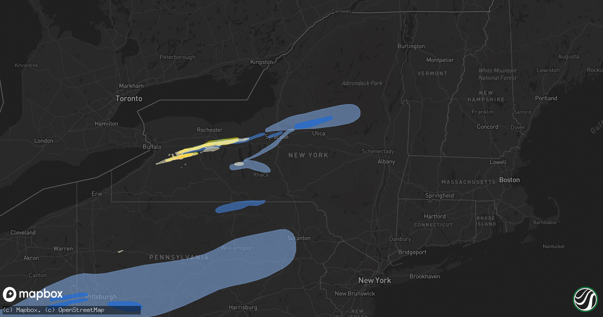
Hail Map in New York on April 29, 2025
Get this storm
April 29 map
$229
one time, instant access
Download today. No call, no setup
Keep the $229
Bought the map and want the full workflow? Apply the entire $229 to a subscription within 7 days. None of it is wasted.
Every map, not just this one
This buys you this map. Subscription and you get every map we run, in the markets you choose from a few cities to whole states to nationwide. Plus real-time alerts the moment a storm fires.
Contact data
Name, contact info, occupancy, even credit band for addresses in the footprint. You go from where it hit to who to call.
Become the source they trust
Unlimited branding weather history reports on demand. You already have the documented answer ready for the property owner, and you are the one who showed up with it.
Property data and RoofTrace estimates
Pull up any address you have got, its value and the exact code rules for that jurisdiction, straight from One Click Code. Then RoofTrace estimates the squares, pitch, and roof value, priced the way you price.
Storm reports in New York
New York
| Date | Description |
|---|---|
| 04/29/20256:47 PM CDT | Trees down on hale road. Time estimated from radar. |
| 04/29/20256:47 PM CDT | Trees down on north broad street in norwich. Time estimated from radar. |
| 04/29/20256:43 PM CDT | Trees down on hammerle road. Time estimated from radar. |
| 04/29/20256:35 PM CDT | Trees down on route 41. Time estimated from radar. |
| 04/29/20256:23 PM CDT | Several reports of trees and wires down in the county. |
| 04/29/20256:21 PM CDT | Partial collapse of elmira drive in movie theater screen. |
| 04/29/20256:11 PM CDT | Trees down in cortland. Time estimated from radar. |
| 04/29/20256:05 PM CDT | Trees and wires down on morgan hill road. Time estimated from radar. |
| 04/29/20256:01 PM CDT | Trees down on searls road. Time estimated from radar. |
| 04/29/20255:59 PM CDT | Trees and wires down on hornby road. Time estimated from radar. |
| 04/29/20255:54 PM CDT | Power pole snapped on route 96 near shared border of towns of romulus and ovid. Second storm that passed through area. |
| 04/29/20255:52 PM CDT | Reports of trees down in wells. |
| 04/29/20255:50 PM CDT | Power lines down. |
| 04/29/20255:47 PM CDT | Wires down on maple street in lodi from second severe storm that passed through area. |
| 04/29/20255:45 PM CDT | Wires down with second severe storm that went through area. Reported to dispatch at 709 pm but radar-estimated time 645 pm. |
| 04/29/20255:38 PM CDT | Wires down at ovid restaurant-gas station from second severe storm that went through area. |
| 04/29/20255:38 PM CDT | Multiple reports of trees and wires down in cameron. Time estimated from radar. |
| 04/29/20255:38 PM CDT | Roof blown off unoccupied house. Wires also down. |
| 04/29/20255:33 PM CDT | Tree on road. |
| 04/29/20255:30 PM CDT | Tree down on state route 54. |
| 04/29/20255:20 PM CDT | Tree and wires down on a home on woods rd. |
| 04/29/20255:18 PM CDT | Trees and wires down on a house in the town of ohio. |
| 04/29/20255:15 PM CDT | Trees and wires down on rose valley rd. |
| 04/29/20255:15 PM CDT | Trees and wires down on rose valley rd. |
| 04/29/20255:15 PM CDT | Report of trees down on state route 8. |
| 04/29/20255:13 PM CDT | Several trees snapped and downed along short cut rd. |
| 04/29/20255:13 PM CDT | Report of trees down on barnhart road. |
| 04/29/20255:04 PM CDT | Corrects previous tstm wnd dmg report from 1 se forestport. Several trees down and snapped in half in the area of division street and river road. Em mgr also reported f |
| 04/29/20255:04 PM CDT | Multiple trees and wires down near o brien road and north lake road. Time estimated from radar. |
| 04/29/20255:04 PM CDT | Several trees down and snapped in half in the area of division street and river road. Time estimated from radar. |
| 04/29/20255:00 PM CDT | At griffiss international airport. |
| 04/29/20255:00 PM CDT | Tree on trailer... 5 people trapped in trailer. Unknown injuries. |
| 04/29/20255:00 PM CDT | Corrects previous tstm wnd dmg report from floyd. Tree fell on manufactured home... With entrapment of 5 residents. |
| 04/29/20254:58 PM CDT | Several trees and wires downed in rome. Metal roof covering peeled back for embargo street structure. Limb down causing minor damage to a business office on thomas stre |
| 04/29/20254:56 PM CDT | Tree down on wires. |
| 04/29/20254:51 PM CDT | Tree on house... Person trapped in basement. |
| 04/29/20254:50 PM CDT | Tree down on house in town of lee. Radar-estimated time. |
| 04/29/20254:43 PM CDT | Multiple trees and wires down across vienna. |
| 04/29/20254:40 PM CDT | A couple fire calls due to downed wires on houses. Radar-estimated time. |
| 04/29/20254:38 PM CDT | Metal docks thrown. Minor roof damage to house. Pictures shared on social media. |
| 04/29/20254:35 PM CDT | Tree and several powerlines down. |
| 04/29/20254:34 PM CDT | Tree down on car with wires involved. No injuries reported. |
| 04/29/20254:34 PM CDT | Tree down on devaul rd. |
| 04/29/20254:34 PM CDT | Tree down... Potentially hit a house as it fell. Wires also down. |
| 04/29/20254:33 PM CDT | Trees and powerlines down. |
| 04/29/20254:23 PM CDT | Large tree branch |
| 04/29/20254:22 PM CDT | Trees and wires down. |
| 04/29/20254:22 PM CDT | At syracuse airport. |
| 04/29/20254:22 PM CDT | Trees and powerlines down. |
| 04/29/20254:20 PM CDT | Trees and powerlines down. |
| 04/29/20254:10 PM CDT | Wires down. |
| 04/29/20254:06 PM CDT | Trees and wires down. Time estimated from radar. |
| 04/29/20254:06 PM CDT | Tree down on a house. |
| 04/29/20254:05 PM CDT | Delayed report. Multiple trees and wired down in the village of port byron and the town of mentz. |
| 04/29/20254:01 PM CDT | Trees down church street. Time estimated from radar. |
| 04/29/20254:01 PM CDT | Trees down church street. Time estimated from radar. |
| 04/29/20254:01 PM CDT | Tree down on valentine road. Time estimated from radar. |
| 04/29/20253:56 PM CDT | Tree down on church street... Corrected time. |
| 04/29/20253:55 PM CDT | Numerous reports of road hazards or downed wires from falling trees and branches including gravel road... Pucker road... Black brook road... And others in town of tyre. |
| 04/29/20253:52 PM CDT | Trees and wires down. |
| 04/29/20253:52 PM CDT | Trees and wires down on sherwood road. Time estimated from radar. |
| 04/29/20253:49 PM CDT | A few trees down on w brook road. |
| 04/29/20253:47 PM CDT | Tree down on wires on near the intersection of dublin road and ninefoot road. |
| 04/29/20253:47 PM CDT | Corrects previous tstm wnd dmg report from dublin. Several road hazards or wires down reports from trees and branches in town of junius... Including dublin road... Nine |
| 04/29/20253:45 PM CDT | Scattered wind damage in area... Including heavy damage to town highway buildings. Radar-estimated time. |
| 04/29/20253:42 PM CDT | Large tree down blocking all of cedar swamp rd. |
| 04/29/20253:42 PM CDT | Trees and wires down on a car. |
| 04/29/20253:40 PM CDT | Large tree down blocking maryland rd. |
| 04/29/20253:40 PM CDT | Tree down on a house with roof damage on mary ave. |
| 04/29/20253:40 PM CDT | Delayed report. Tree on a house in mcburney road in phelps. |
| 04/29/20253:40 PM CDT | Tree down on mobile home. |
| 04/29/20253:40 PM CDT | Roof damage to several barns. |
| 04/29/20253:40 PM CDT | *** 1 inj *** tree down on mobile home with significant damage. 1 occupant injured. |
| 04/29/20253:40 PM CDT | Trees and powerlines down along stephens st. |
| 04/29/20253:40 PM CDT | Large tree down blocking route 88. |
| 04/29/20253:38 PM CDT | Tree down on an unoccupied car. |
| 04/29/20253:37 PM CDT | Garage destroyed. |
| 04/29/20253:37 PM CDT | Tree down on a house and powerlines. |
| 04/29/20253:35 PM CDT | Tree down on house on west main st. |
| 04/29/20253:35 PM CDT | Power pole snapped. |
| 04/29/20253:34 PM CDT | Tree down on house on east ave. |
| 04/29/20253:34 PM CDT | Power pole down on car. |
| 04/29/20253:34 PM CDT | Tree down on h |
| 04/29/20253:32 PM CDT | Large tree down partially blocking route 96. |
| 04/29/20253:30 PM CDT | A local report indicates 58 MPH wind near 2 N Piffard |
| 04/29/20253:28 PM CDT | Tree down blocking roadway. |
| 04/29/20253:28 PM CDT | A local report indicates 1.00 inch wind near Warsaw |
| 04/29/20253:26 PM CDT | Large tree down blocking most of sand hill rd. |
| 04/29/20253:22 PM CDT | Tree down blocking victoria ln. |
| 04/29/20253:22 PM CDT | Tree down on house. |
| 04/29/20253:20 PM CDT | Large tree down blocking route 444. |
| 04/29/20253:19 PM CDT | Large tree down blocking county route 39. |
| 04/29/20253:16 PM CDT | Trees down in the town of webster. |
| 04/29/20253:15 PM CDT | Delayed report. Photo on social media of half dollar sized hail in honeoye falls. |
| 04/29/20253:14 PM CDT | A local report indicates 1.00 inch wind near 3 NNE Strykersville |
| 04/29/20253:10 PM CDT | Trees down in the town of irondequoit. |
| 04/29/20253:10 PM CDT | Numerous trees and powerlines down in most of the towns in the northern half of wyoming county. |
| 04/29/20253:10 PM CDT | A local report indicates 60 MPH wind near 4 NW Warsaw |
| 04/29/20253:10 PM CDT | A local report indicates 1.00 inch wind near Lima |
| 04/29/20253:04 PM CDT | Trees... Powerlines... And power poles down. |
| 04/29/20253:03 PM CDT | A local report indicates 1.00 inch wind near 2 NNE Holland |
| 04/29/20253:02 PM CDT | Large tree down on a house. 349) 2115 w 1 w pittsburgh allegheny pa 4044 8000 windows blown out of high rise building in dow |
| 04/29/20253:02 PM CDT | Large tree down on a house. |
| 04/29/20252:58 PM CDT | Delayed report... Time estimated based on radar. Trees and wires down in caledonia. |
| 04/29/20252:55 PM CDT | Delayed report. Swath of snapped power poles on route 36 north of york. |
| 04/29/20252:53 PM CDT | Trees... Powerlines... And power poles down in the town of york. |
| 04/29/20252:46 PM CDT | Delayed report. 1.25 inch hail measured in covington. |
| 04/29/20252:46 PM CDT | Delayed report. Large trees uprooted in covington. |
| 04/29/20252:37 PM CDT | Delayed report. Golf ball sized hail reported in warsaw. |
| 04/29/20252:30 PM CDT | Trees and powerlines down in several towns in the northern portion of the county. |
| 04/28/20257:22 PM CDT | Estimated. |
| 04/28/20257:20 PM CDT | Transformer on fire. |
| 04/28/20257:02 PM CDT | Trees and wires down in the area. |
All States Impacted by Hail Map on April 29, 2025
Cities Impacted by Hail Map on April 29, 2025
- McCune, KS
- Cherokee, KS
- Delaware, OK
- Coffeyville, KS
- Nowata, OK
- Lenapah, OK
- Red Bud, IL
- S Coffeyville, OK
- Baldwin, IL
- Collinsville, OK
- Ramona, OK
- Vera, OK
- Ochelata, OK
- Skiatook, OK
- Pittsburg, KS
- Sperry, OK
- Owasso, OK
- Tulsa, OK
- Claremore, OK
- Oswego, KS
- Edna, KS
- Bartlett, KS
- Girard, KS
- Vinita, OK
- Talala, OK
- Oologah, OK
- Marissa, IL
- Coulterville, IL
- Westfield, IL
- Ashmore, IL
- Casey, IL
- New Athens, IL
- Lenzburg, IL
- Weir, KS
- Welch, OK
- Chelsea, OK
- Tilden, IL
- Sparta, IL
- Adair, OK
- Pryor, OK
- Big Cabin, OK
- Chetopa, KS
- Scammon, KS
- Oakdale, IL
- Nashville, IL
- Martinsville, IL
- Marshall, IL
- Kansas, IL
- Paris, IL
- Frontenac, KS
- Mindenmines, MO
- Columbus, KS
- Ramsey, IL
- Vandalia, IL
- Addieville, IL
- Strang, OK
- Spavinaw, OK
- Brownstown, IL
- Beecher City, IL
- Saint Elmo, IL
- Dennison, IL
- Riverton, KS
- Galena, KS
- Joplin, MO
- Miami, OK
- North Miami, OK
- Commerce, OK
- Carl Junction, MO
- Asbury, MO
- Afton, OK
- Ketchum, OK
- Eucha, OK
- Jay, OK
- Grove, OK
- Wyandotte, OK
- Webb City, MO
- Oronogo, MO
- Altamont, IL
- Odin, IL
- Baxter Springs, KS
- West Terre Haute, IN
- Salem, IL
- Fairland, OK
- Sheldon, MO
- Lamar, MO
- Effingham, IL
- Shumway, IL
- Carterville, MO
- Carthage, MO
- Diamond, MO
- Duenweg, MO
- Purcell, MO
- Jasper, MO
- Neck City, MO
- Alba, MO
- Gravette, AR
- South West City, MO
- Anderson, MO
- Noel, MO
- Tiff City, MO
- Goodman, MO
- Seneca, MO
- Neosho, MO
- Pineville, MO
- Lanagan, MO
- Texico, IL
- Bluford, IL
- Kinmundy, IL
- Iuka, IL
- Xenia, IL
- Louisville, IL
- Kell, IL
- Teutopolis, IL
- Granby, MO
- Stella, MO
- Powell, MO
- Rocky Comfort, MO
- Stark City, MO
- Wheaton, MO
- Exeter, MO
- Fairview, MO
- Purdy, MO
- Pierce City, MO
- Wentworth, MO
- Reeds, MO
- Avilla, MO
- Sigel, IL
- La Russell, MO
- Sarcoxie, MO
- Golden City, MO
- Monett, MO
- Stotts City, MO
- Butterfield, MO
- Cassville, MO
- Miller, MO
- Lockwood, MO
- Verona, MO
- Mount Vernon, MO
- Freistatt, MO
- Aurora, MO
- Crane, MO
- Claremont, IL
- Dundas, IL
- Newton, IL
- Ingraham, IL
- South Greenfield, MO
- Marionville, MO
- Galena, MO
- Billings, MO
- Ash Grove, MO
- Nixa, MO
- Clever, MO
- Bois D Arc, MO
- Republic, MO
- Halltown, MO
- Everton, MO
- Inola, OK
- Chouteau, OK
- Locust Grove, OK
- Salina, OK
- Rose, OK
- Colcord, OK
- Kansas, OK
- Gentry, AR
- Maysville, AR
- Bentonville, AR
- Decatur, AR
- Rogers, AR
- Centerton, AR
- Pea Ridge, AR
- Hiwasse, AR
- Sulphur Springs, AR
- Seligman, MO
- Bella Vista, AR
- Washburn, MO
- Bridgeport, IL
- Flat Rock, IL
- Sumner, IL
- West Liberty, IL
- Willard, MO
- Brookline, MO
- Ozark, MO
- Walnut Grove, MO
- Springfield, MO
- Rogersville, MO
- Fair Grove, MO
- Oblong, IL
- Robinson, IL
- Oaktown, IN
- Palestine, IL
- Willow Hill, IL
- Lawrenceville, IL
- Carlisle, IN
- Highlandville, MO
- Cape Fair, MO
- Ponce De Leon, MO
- Reeds Spring, MO
- Spokane, MO
- Chestnutridge, MO
- Walnut Shade, MO
- Forsyth, MO
- Garrison, MO
- Oldfield, MO
- Sparta, MO
- Taneyville, MO
- Chadwick, MO
- Strafford, MO
- Marshfield, MO
- Fordland, MO
- Bruner, MO
- Pleasant Hope, MO
- Linton, IN
- Merom, IN
- Sullivan, IN
- Brighton, MO
- Elkland, MO
- Buffalo, MO
- Conway, MO
- Seymour, MO
- Niangua, MO
- Ava, MO
- Bradleyville, MO
- Mansfield, MO
- Squires, MO
- Bolivar, MO
- Lyons, IN
- Switz City, IN
- Worthington, IN
- Bloomfield, IN
- Dugger, IN
- Sandborn, IN
- Norwood, MO
- Grovespring, MO
- Phillipsburg, MO
- Macomb, MO
- Hartville, MO
- Lebanon, MO
- Louisburg, MO
- Half Way, MO
- Allen, OK
- Drury, MO
- Mountain Grove, MO
- Falcon, MO
- Lynchburg, MO
- Atwood, OK
- Laquey, MO
- Graff, MO
- Paragon, IN
- Martinsville, IN
- Morgantown, IN
- Trafalgar, IN
- Franklin, IN
- Bargersville, IN
- Plato, MO
- Huggins, MO
- Cabool, MO
- Houston, MO
- Bucyrus, MO
- Success, MO
- Roby, MO
- Licking, MO
- Waynesville, MO
- Duke, MO
- Fort Leonard Wood, MO
- Edinburgh, IN
- Needham, IN
- Shelbyville, IN
- Boggstown, IN
- Vichy, MO
- Vienna, MO
- Solo, MO
- Yukon, MO
- Raymondville, MO
- Eunice, MO
- Hartshorn, MO
- Fairland, IN
- Manilla, IN
- Morristown, IN
- Arlington, IN
- Beulah, MO
- Edgar Springs, MO
- Newburg, MO
- Salem, MO
- Lenox, MO
- Homer, IN
- Rushville, IN
- Waldron, IN
- Milroy, IN
- Seymour, IN
- Columbus, IN
- Flat Rock, IN
- Rolla, MO
- Bluejacket, OK
- Glenwood, IN
- Quapaw, OK
- Picher, OK
- Treece, KS
- Connersville, IN
- Laurel, IN
- Greensburg, IN
- Scipio, IN
- North Vernon, IN
- Butlerville, IN
- Elizabethtown, IN
- Jonesville, IN
- Birch Tree, MO
- Metamora, IN
- Liberty, IN
- Brookville, IN
- Hope, IN
- Saint Paul, IN
- Batesville, IN
- Oldenburg, IN
- Holton, IN
- Versailles, IN
- Osgood, IN
- Westport, IN
- Winona, MO
- Eminence, MO
- Boss, MO
- Goshen, KY
- Milan, IN
- Cedar Grove, IN
- New Trenton, IN
- West Harrison, IN
- Brownsville, IN
- Centerville, IN
- Richmond, IN
- Eaton, OH
- Boston, IN
- Camden, OH
- West College Corner, IN
- College Corner, OH
- Oxford, OH
- Bath, IN
- Hamilton, OH
- Okeana, OH
- Vian, OK
- La Grange, KY
- Crestwood, KY
- Van Buren, MO
- Bunch, OK
- Sallisaw, OK
- Somerville, OH
- West Alexandria, OH
- Lewisburg, OH
- Dillsboro, IN
- Moores Hill, IN
- Guilford, IN
- Aurora, IN
- Sunman, IN
- Piedmont, MO
- Ellington, MO
- Stilwell, OK
- Ellsinore, MO
- Brookville, OH
- Germantown, OH
- New Lebanon, OH
- Farmersville, OH
- Fredericktown, MO
- Mill Spring, MO
- Cleves, OH
- Cincinnati, OH
- Perryville, MO
- Patton, MO
- Patterson, MO
- Fort Stockton, TX
- Potosi, MO
- Dayton, OH
- Vandalia, OH
- Clayton, OH
- Englewood, OH
- Tipp City, OH
- Troy, OH
- New Carlisle, OH
- Medway, OH
- Springfield, OH
- Urbana, OH
- Tremont City, OH
- North Hampton, OH
- Saint Paris, OH
- West Milton, OH
- Imperial, TX
- Silva, MO
- North Bend, OH
- Greenville, MO
- Plain City, OH
- West Jefferson, OH
- Amlin, OH
- Dublin, OH
- Delaware, OH
- Powell, OH
- Hilliard, OH
- Lewis Center, OH
- Westerville, OH
- Columbus, OH
- Galloway, OH
- Galena, OH
- New Albany, OH
- Sunbury, OH
- Johnstown, OH
- Pleasureville, KY
- Bethlehem, KY
- New Castle, KY
- Smithfield, KY
- Sulphur, KY
- Pendleton, KY
- Ashley, IL
- Okawville, IL
- Eminence, KY
- Richview, IL
- Sims, IL
- Geff, IL
- Meadow, TX
- Ropesville, TX
- Wayne City, IL
- Vergennes, IL
- Campbellsburg, KY
- Keenes, IL
- Owenton, KY
- Lockport, KY
- Flora, IL
- Odonnell, TX
- Tahoka, TX
- Clay City, IL
- Noble, IL
- Perry Park, KY
- Turners Station, KY
- Cisne, IL
- Crane, TX
- Wolfforth, TX
- Lubbock, TX
- Attica, NY
- Warsaw, NY
- Olney, IL
- Varysburg, NY
- Anna, IL
- Makanda, IL
- Carbondale, IL
- Cobden, IL
- Johnsonville, IL
- Dale, NY
- Wyoming, NY
- Pavilion, NY
- Piffard, NY
- Centralia, IL
- East China, MI
- Marine City, MI
- Cannelburg, IN
- Montgomery, IN
- Strykersville, NY
- Vincennes, IN
- Pinckneyville, IL
- Hoyleton, IL
- Georgetown, KY
- Sadieville, KY
- Woodlawn, IL
- Bicknell, IN
- Ragsdale, IN
- Sikeston, MO
- Loogootee, IN
- York, NY
- Avon, NY
- Caledonia, NY
- Linwood, NY
- Ewing, IL
- Belle Rive, IL
- Ina, IL
- Elnora, IN
- Plainville, IN
- Washington, IN
- Edwardsport, IN
- Post, TX
- Crane, IN
- Cynthiana, KY
- Reynoldsburg, OH
- Millersport, OH
- Etna, OH
- Baltimore, OH
- Blacklick, OH
- Pataskala, OH
- Hebron, OH
- Heath, OH
- Kirkersville, OH
- Zanesville, OH
- Granville, OH
- Hopewell, OH
- Mount Perry, OH
- Glenford, OH
- Jacksontown, OH
- Alexandria, OH
- Buckeye Lake, OH
- Thornville, OH
- Nashport, OH
- Norwich, OH
- New Concord, OH
- Chandlersville, OH
- Newark, OH
- Frazeysburg, OH
- Saint Louisville, OH
- Adamsville, OH
- Dresden, OH
- Trinway, OH
- Cambridge, OH
- Kipling, OH
- Lore City, OH
- Byesville, OH
- Cumberland, OH
- Pleasant City, OH
- Quaker City, OH
- Salesville, OH
- Old Washington, OH
- Senecaville, OH
- Kimbolton, OH
- Java Village, NY
- North Java, NY
- Holland, NY
- Jerusalem, OH
- Barnesville, OH
- Piedmont, OH
- Freeport, OH
- Flushing, OH
- Cadiz, OH
- Bethesda, OH
- Port Washington, OH
- Smithfield, OH
- Saint Clairsville, OH
- Mingo Junction, OH
- Steubenville, OH
- Morristown, OH
- Dillonvale, OH
- Adena, OH
- Rayland, OH
- Belmont, OH
- Bloomingdale, OH
- Yorkville, OH
- Neffs, OH
- Alledonia, OH
- Glen Dale, WV
- Bridgeport, OH
- Bellaire, OH
- Moundsville, WV
- Wheeling, WV
- Windsor Heights, WV
- Brilliant, OH
- Shadyside, OH
- Beallsville, OH
- Wellsburg, WV
- Jacobsburg, OH
- Powhatan Point, OH
- Beech Bottom, WV
- Martins Ferry, OH
- Glen Easton, WV
- Mcmechen, WV
- Benwood, WV
- Mount Pleasant, OH
- Tiltonsville, OH
- Duncan Falls, OH
- Hopedale, OH
- Tippecanoe, OH
- Scio, OH
- Jewett, OH
- Richmond, OH
- Hammondsville, OH
- Amsterdam, OH
- Bergholz, OH
- Toronto, OH
- Irondale, OH
- Newell, WV
- New Cumberland, WV
- East Springfield, OH
- Wellsville, OH
- Leesville, OH
- Carrollton, OH
- Dennison, OH
- Bowerston, OH
- Midvale, OH
- Gnadenhutten, OH
- Uhrichsville, OH
- Tuscarawas, OH
- Salineville, OH
- New Philadelphia, OH
- Newcomerstown, OH
- Sherrodsville, OH
- Coshocton, OH
- Walhonding, OH
- Utica, OH
- Blissfield, OH
- Warsaw, OH
- Stone Creek, OH
- Fresno, OH
- Conesville, OH
- Plainfield, OH
- West Lafayette, OH
- Idalou, TX
- Blue Rock, OH
- White Cottage, OH
- Philo, OH
- Roseville, OH
- Sarahsville, OH
- Lewisville, OH
- Summerfield, OH
- Woodsfield, OH
- Caldwell, OH
- Cameron, WV
- Proctor, WV
- Asher, OK
- Konawa, OK
- Perry, NY
- Gail, TX
- Jayton, TX
- Aspermont, TX
- Follansbee, WV
- Colliers, WV
- Burgettstown, PA
- Weirton, WV
- Chester, WV
- Stratton, OH
- New Manchester, WV
- Hookstown, PA
- Midland, PA
- Georgetown, PA
- Empire, OH
- South Heights, PA
- Aliquippa, PA
- West Alexander, PA
- Monaca, PA
- Baden, PA
- West Liberty, WV
- Shippingport, PA
- Langeloth, PA
- Claysville, PA
- Avella, PA
- Clinton, PA
- Imperial, PA
- Valley Grove, WV
- Crescent, PA
- Industry, PA
- Dallas, WV
- Bethany, WV
- Sewickley, PA
- Bulger, PA
- Ambridge, PA
- Atlasburg, PA
- Triadelphia, WV
- Leetsdale, PA
- Joffre, PA
- Coraopolis, PA
- Slovan, PA
- Strabane, PA
- Meadow Lands, PA
- Eighty Four, PA
- Southview, PA
- Oakdale, PA
- McDonald, PA
- Canonsburg, PA
- Washington, PA
- West Finley, PA
- Hickory, PA
- Muse, PA
- Cuddy, PA
- Midway, PA
- Sturgeon, PA
- Westland, PA
- Amity, PA
- Houston, PA
- Pittsburgh, PA
- Cecil, PA
- Prosperity, PA
- Carlisle, KY
- Lorenzo, TX
- Leicester, NY
- Mount Morris, NY
- Dahlgren, IL
- Heltonville, IN
- Bedford, IN
- Newberry, IN
- Williams, IN
- Mound City, IL
- McCamey, TX
- Ozona, TX
- Odon, IN
- Calhoun, IL
- Colden, NY
- Stamping Ground, KY
- Victor, NY
- Bloomfield, NY
- Honeoye Falls, NY
- Lima, NY
- Clifton Springs, NY
- Canandaigua, NY
- Farmington, NY
- Manchester, NY
- Shortsville, NY
- Shoals, IN
- Macomb, OK
- Barnhill, IL
- Fairfield, IL
- Boston, NY
- Springville, NY
- Ozark, IL
- Stonefort, IL
- Barlow, KY
- Arcade, NY
- South Wales, NY
- Gainesville, NY
- Tecumseh, OK
- Ionia, NY
- Byars, OK
- Ada, OK
- Freelandville, IN
- Scotland, IN
- Bruceville, IN
- Westphalia, IN
- East Aurora, NY
- Eden, NY
- West Bloomfield, NY
- Cowlesville, NY
- Maud, OK
- Iraan, TX
- Lenorah, TX
- Retsof, NY
- Lamesa, TX
- Geneseo, NY
- Livonia, NY
- Lakeville, NY
- Phelps, NY
- Waterloo, NY
- Geneva, NY
- Lyons, NY
- Clyde, NY
- Seneca Falls, NY
- Weedsport, NY
- Port Byron, NY
- Montezuma, NY
- Savannah, NY
- Cayuga, NY
- Ovid, NY
- Aurora, NY
- Palmyra, NY
- Fairview, OK
- North Collins, NY
- Justiceburg, TX
- Owensburg, IN
- Springville, IN
- Dryden, TX
- Newark, NY
- Silver Springs, NY
- Java Center, NY
- Otwell, IN
- Petersburg, IN
- Shelbyville, KY
- Glenwood, NY
- Lawtons, NY
- King Ferry, NY
- Scipio Center, NY
- Nineveh, PA
- Sycamore, PA
- Bridgeville, PA
- Marianna, PA
- Scenery Hill, PA
- Graysville, PA
- Morgan, PA
- Waynesburg, PA
- Venetia, PA
- Presto, PA
- Lawrence, PA
- Fredericktown, PA
- Clarksville, PA
- Carnegie, PA
- Cokeburg, PA
- McKees Rocks, PA
- De Soto, IL
- Murphysboro, IL
- Ackerly, TX
- Cambria, IL
- Carterville, IL
- Hurst, IL
- Grand Tower, IL
- Energy, IL
- Herrin, IL
- Benton, IL
- Johnston City, IL
- Freeman Spur, IL
- Royalton, IL
- Zeigler, IL
- Mulkeytown, IL
- Orient, IL
- West Frankfort, IL
- Buckner, IL
- Elkville, IL
- Christopher, IL
- Sesser, IL
- Whittington, IL
- Macedonia, IL
- Bonnie, IL
- Thompsonville, IL
- Logan, IL
- McLeansboro, IL
- Springerton, IL
- Enfield, IL
- Mill Shoals, IL
- Burnt Prairie, IL
- Carmi, IL
- Albion, IL
- Golden Gate, IL
- Crossville, IL
- Grayville, IL
- Ellery, IL
- Griffin, IN
- Browns, IL
- Mount Carmel, IL
- Owensville, IN
- West Salem, IL
- Bellmont, IL
- Bone Gap, IL
- Princeton, IN
- Hazleton, IN
- Monroe City, IN
- Patoka, IN
- Francisco, IN
- Saint Francisville, IL
- Allendale, IL
- Decker, IN
- Wheatland, IN
- Wewoka, OK
- Brownstown, IN
- Avoca, IN
- Snyder, TX
- Natrona Heights, PA
- Dravosburg, PA
- Glenshaw, PA
- Duquesne, PA
- Mars, PA
- Russellton, PA
- Sarver, PA
- Gibsonia, PA
- Saxonburg, PA
- Springdale, PA
- Oakmont, PA
- Valencia, PA
- Bentleyville, PA
- Coal Center, PA
- Creighton, PA
- Charleroi, PA
- South Park, PA
- Bunola, PA
- Harwick, PA
- Verona, PA
- Mckeesport, PA
- Finleyville, PA
- Freedom, PA
- Tarentum, PA
- Conway, PA
- Daisytown, PA
- Bairdford, PA
- Clairton, PA
- Braddock, PA
- New Eagle, PA
- Warrendale, PA
- Allison Park, PA
- Cranberry Township, PA
- Beallsville, PA
- Elrama, PA
- Indianola, PA
- Bethel Park, PA
- Wexford, PA
- Glassport, PA
- Van Voorhis, PA
- Ellsworth, PA
- West Mifflin, PA
- Cheswick, PA
- Bradfordwoods, PA
- New Kensington, PA
- Monongahela, PA
- Turtle Creek, PA
- Bakerstown, PA
- Homestead, PA
- Richeyville, PA
- Tarrs, PA
- Smithton, PA
- Darragh, PA
- Bovard, PA
- Claridge, PA
- Brackenridge, PA
- East Pittsburgh, PA
- Belle Vernon, PA
- Monessen, PA
- Stockdale, PA
- Buena Vista, PA
- Freeport, PA
- Rillton, PA
- Donora, PA
- Everson, PA
- Latrobe, PA
- Roscoe, PA
- Brownsville, PA
- Forbes Road, PA
- Scottdale, PA
- Yukon, PA
- Saltsburg, PA
- Jeannette, PA
- Hannastown, PA
- Penn, PA
- Larimer, PA
- Sutersville, PA
- California, PA
- Grindstone, PA
- Pleasant Unity, PA
- Vanderbilt, PA
- Wyano, PA
- Star Junction, PA
- Trafford, PA
- Slickville, PA
- Connellsville, PA
- New Stanton, PA
- Export, PA
- Elco, PA
- Pitcairn, PA
- Harrison City, PA
- Hunker, PA
- New Alexandria, PA
- Leechburg, PA
- Greenock, PA
- Dunlevy, PA
- Newell, PA
- Arona, PA
- Wickhaven, PA
- Alverton, PA
- Madison, PA
- Luxor, PA
- Wilmerding, PA
- Ligonier, PA
- Webster, PA
- Westmoreland City, PA
- Greensburg, PA
- Allenport, PA
- Hostetter, PA
- Lowber, PA
- West Newton, PA
- East McKeesport, PA
- Stahlstown, PA
- Adamsburg, PA
- Ardara, PA
- Fayette City, PA
- Acme, PA
- Youngwood, PA
- North Versailles, PA
- Irwin, PA
- Perryopolis, PA
- Dawson, PA
- Murrysville, PA
- Donegal, PA
- Mount Pleasant, PA
- West Elizabeth, PA
- Manor, PA
- Monroeville, PA
- Apollo, PA
- Grapeville, PA
- Crabtree, PA
- Herminie, PA
- Ruffs Dale, PA
- Delmont, PA
- Elizabeth, PA
- Baldwinsville, NY
- Warners, NY
- Liverpool, NY
- Clay, NY
- Phoenix, NY
- Ralls, TX
- Floydada, TX
- Syracuse, NY
- Cicero, NY
- Pennellville, NY
- Brewerton, NY
- East Syracuse, NY
- Sylvan Beach, NY
- Durhamville, NY
- Cleveland, NY
- Chittenango, NY
- Bridgeport, NY
- Canastota, NY
- Kirkville, NY
- Verona Beach, NY
- Jordan, NY
- Memphis, NY
- Dickens, TX
- Paducah, TX
- Camillus, NY
- Old Glory, TX
- Moravia, NY
- Auburn, NY
- Skaneateles, NY
- Marietta, NY
- Tully, NY
- Nedrow, NY
- La Fayette, NY
- Jamesville, NY
- Fayetteville, NY
- Minoa, NY
- Holdenville, OK
- Sasakwa, OK
- Bradenville, PA
- Youngstown, PA
- Aultman, PA
- Kittanning, PA
- Clune, PA
- Rural Valley, PA
- Marion Center, PA
- East Vandergrift, PA
- Elderton, PA
- Vandergrift, PA
- Lucernemines, PA
- Spring Church, PA
- Home, PA
- Loyalhanna, PA
- Indiana, PA
- Coral, PA
- Black Lick, PA
- Hyde Park, PA
- Derry, PA
- West Lebanon, PA
- Creekside, PA
- New Derry, PA
- Homer City, PA
- Ford City, PA
- Shelocta, PA
- North Apollo, PA
- Blairsville, PA
- Clarksburg, PA
- McIntyre, PA
- Avonmore, PA
- Josephine, PA
- Mitchell, IN
- West Baden Springs, IN
- Lawrenceburg, KY
- Bardstown, KY
- Taylorsville, KY
- Blossvale, NY
- West Monroe, NY
- Central Square, NY
- North Bay, NY
- Camden, NY
- Bernhards Bay, NY
- Constantia, NY
- Ford Cliff, PA
- Cadogan, PA
- Manorville, PA
- Sagamore, PA
- Butler, PA
- McGrann, PA
- Cabot, PA
- Worthington, PA
- New Brighton, PA
- Zelienople, PA
- Callery, PA
- Beaver, PA
- Rochester, PA
- Harmony, PA
- Fombell, PA
- Evans City, PA
- Renfrew, PA
- East Liverpool, OH
- Darlington, PA
- New Galilee, PA
- Koppel, PA
- Ellwood City, PA
- Beaver Falls, PA
- Wampum, PA
- Lisbon, OH
- Mechanicstown, OH
- Rogers, OH
- Negley, OH
- East Palestine, OH
- Connoquenessing, PA
- Summitville, OH
- Dellroy, OH
- Kensington, OH
- Mineral City, OH
- Hanoverton, OH
- London, KY
- Girard, TX
- Mount Eden, KY
- Coxs Creek, KY
- Bloomfield, KY
- Spur, TX
- Waddy, KY
- Boston, KY
- New Haven, KY
- Fairfield, KY
- Bowling Green, KY
- Orleans, IN
- Dilltown, PA
- Marsteller, PA
- Johnstown, PA
- Ernest, PA
- Ebensburg, PA
- Clymer, PA
- Robinson, PA
- Dixonville, PA
- Nicktown, PA
- Hastings, PA
- Brush Valley, PA
- Emeigh, PA
- Cherry Tree, PA
- Heilwood, PA
- Rector, PA
- Commodore, PA
- Spangler, PA
- New Florence, PA
- Twin Rocks, PA
- Mentcle, PA
- Northern Cambria, PA
- Alverda, PA
- Seward, PA
- Laughlintown, PA
- Boswell, PA
- Starford, PA
- Penn Run, PA
- Armagh, PA
- Strongstown, PA
- Vintondale, PA
- Belsano, PA
- Bolivar, PA
- Carrolltown, PA
- Stoystown, PA
- Champion, PA
- Nanty Glo, PA
- Friedens, PA
- Somerset, PA
- Acosta, PA
- White, PA
- Jennerstown, PA
- Jones Mills, PA
- Quecreek, PA
- Jenners, PA
- Hollsopple, PA
- Gray, PA
- Hernando, MS
- Chaplin, KY
- Frankfort, KY
- Springfield, KY
- Nesbit, MS
- Saint Francis, KY
- New Hope, KY
- Wetumka, OK
- Versailles, KY
- Loretto, KY
- Mount Sherman, KY
- Lebanon, KY
- Seven Mile, OH
- Rome, NY
- Verona, NY
- Taberg, NY
- Whitesboro, NY
- Vernon, NY
- Westmoreland, NY
- Clinton, NY
- Oriskany, NY
- Marcy, NY
- Holland Patent, NY
- Stittville, NY
- Lee Center, NY
- Ava, NY
- Forestport, NY
- Boonville, NY
- Westernville, NY
- Woodgate, NY
- Williamstown, NY
- Remsen, NY
- Utica, NY
- Barneveld, NY
- Poland, NY
- Alder Creek, NY
- Prospect, NY
- Midway, KY
- Dustin, OK
- Saint Catharine, KY
- Franklin, OH
- Middletown, OH
- Salem, IN
- Trenton, OH
- Buffalo, KY
- Willisburg, KY
- Southaven, MS
- Berry, KY
- Glen Campbell, PA
- Gipsy, PA
- Arcadia, PA
- Mahaffey, PA
- Rochester Mills, PA
- Hillsdale, PA
- Westover, PA
- La Jose, PA
- Grampian, PA
- Burnside, PA
- Rossiter, PA
- Templeton, PA
- Punxsutawney, PA
- Smicksburg, PA
- Adrian, PA
- Hamilton, PA
- Big Run, PA
- Fenelton, PA
- Cowansville, PA
- New Bethlehem, PA
- Walston, PA
- Northpoint, PA
- Dayton, PA
- Valier, PA
- Luthersburg, PA
- Yatesboro, PA
- Seymour, TX
- Somerset, KY
- Corbin, KY
- Keavy, KY
- Miamisburg, OH
- Emlenton, PA
- Knox, PA
- Monroe, OH
- Falmouth, KY
- Scottsburg, IN
- Mammoth Cave, KY
- Sweeden, KY
- Corinth, KY
- Weleetka, OK
- Little Falls, NY
- Newport, NY
- Cold Brook, NY
- Salisbury Center, NY
- Eufaula, OK
- Hanna, OK
- Stratford, NY
- Hoffmeister, NY
- Caroga Lake, NY
- Lamar, OK
- Piseco, NY
- Lake Pleasant, NY
- Hammondsport, NY
- Dundee, NY
- Bradford, NY
- Penn Yan, NY
- Branchport, NY
- Prattsburgh, NY
- Pulteney, NY
- Keuka Park, NY
- Himrod, NY
- Lodi, NY
- Interlaken, NY
- Hector, NY
- Salix, PA
- Mineral Point, PA
- New Enterprise, PA
- Colver, PA
- New Millport, PA
- Claysburg, PA
- Hopewell, PA
- Patton, PA
- Coalport, PA
- Portage, PA
- Parkhill, PA
- Windber, PA
- Hollidaysburg, PA
- Ashville, PA
- Woodbury, PA
- Cresson, PA
- New Paris, PA
- Sproul, PA
- Davidsville, PA
- Osterburg, PA
- Loysburg, PA
- Flinton, PA
- Loretto, PA
- Central City, PA
- Irvona, PA
- Seanor, PA
- South Fork, PA
- Lilly, PA
- Saint Benedict, PA
- Elmora, PA
- Schellsburg, PA
- Elton, PA
- Queen, PA
- East Freedom, PA
- Hooversville, PA
- Saxton, PA
- Bedford, PA
- Cairnbrook, PA
- Alum Bank, PA
- Fallentimber, PA
- Gallitzin, PA
- Chest Springs, PA
- Cassandra, PA
- Altoona, PA
- Jerome, PA
- Sidman, PA
- Wilmore, PA
- Imler, PA
- Martinsburg, PA
- Everett, PA
- Roaring Spring, PA
- Six Mile Run, PA
- Fishertown, PA
- Duncansville, PA
- Newry, PA
- Saint Michael, PA
- Summerhill, PA
- Beaverdale, PA
- Curwensville, PA
- Dysart, PA
- Saint Boniface, PA
- Williamsburg, PA
- Madera, PA
- Tyrone, PA
- James Creek, PA
- Glen Hope, PA
- Blandburg, PA
- Lebanon, OH
- Munson, PA
- Karthaus, PA
- Morrisdale, PA
- Tipton, PA
- Pennsylvania Furnace, PA
- Warriors Mark, PA
- Ramey, PA
- Osceola Mills, PA
- Smithmill, PA
- Bellwood, PA
- Allport, PA
- Frenchville, PA
- Clarence, PA
- Clearfield, PA
- Sandy Ridge, PA
- Wallaceton, PA
- Alexandria, PA
- Kylertown, PA
- Spruce Creek, PA
- Brisbin, PA
- Woodland, PA
- Beccaria, PA
- Hawk Run, PA
- Julian, PA
- West Decatur, PA
- Hesston, PA
- Moshannon, PA
- Philipsburg, PA
- Olanta, PA
- Houtzdale, PA
- Mineral Springs, PA
- Glen Richey, PA
- Entriken, PA
- Snow Shoe, PA
- Hyde, PA
- Lanse, PA
- Port Matilda, PA
- Grassflat, PA
- Bigler, PA
- Drifting, PA
- Winburne, PA
- Lockney, TX
- Midkiff, TX
- Lawrenceburg, IN
- Petersburg, KY
- Benjamin, TX
- Hebron, KY
- Clarksville, TN
- Russellville, KY
- Mason, OH
- Auburn, KY
- Lewisburg, KY
- Olive Branch, MS
- Addyston, OH
- Hennessey, OK
- Waukomis, OK
- Speculator, NY
- Wells, NY
- Trumansburg, NY
- Groton, NY
- Lansing, NY
- Locke, NY
- Genoa, NY
- Ithaca, NY
- Crowell, TX
- Freeville, NY
- Dryden, NY
- Douglas, OK
- Brownsville, KY
- Smiths Grove, KY
- O'Brien, TX
- Knox City, TX
- Henryetta, OK
- Mount Olivet, KY
- Oakland, KY
- Big Lake, TX
- Bison, OK
- Drummond, OK
- Osceola, PA
- Middlebury Center, PA
- Knoxville, PA
- Westfield, PA
- Wellsboro, PA
- Lawrenceville, PA
- Nelson, PA
- Millerton, PA
- Tioga, PA
- Mansfield, PA
- Loganton, PA
- Lock Haven, PA
- University Park, PA
- Mill Hall, PA
- Fleming, PA
- Huntingdon, PA
- Orviston, PA
- Beech Creek, PA
- Rebersburg, PA
- Petersburg, PA
- Howard, PA
- Lamar, PA
- Centre Hall, PA
- Boalsburg, PA
- Madisonburg, PA
- Blanchard, PA
- Pine Grove Mills, PA
- Lemont, PA
- Bellefonte, PA
- Milesburg, PA
- State College, PA
- Spring Mills, PA
- Jersey Shore, PA
- Burnham, PA
- Belleville, PA
- Todd, PA
- McClure, PA
- Cassville, PA
- Calvin, PA
- Orbisonia, PA
- Mifflintown, PA
- Avis, PA
- Mount Union, PA
- Yeagertown, PA
- East Waterford, PA
- Granville, PA
- McVeytown, PA
- Lewistown, PA
- Mill Creek, PA
- Milroy, PA
- Millmont, PA
- Mapleton Depot, PA
- Port Royal, PA
- Aaronsburg, PA
- Millheim, PA
- Reedsville, PA
- Mifflin, PA
- Woodward, PA
- Coburn, PA
- Allensville, PA
- Honey Grove, PA
- McAlisterville, PA
- Beaver Springs, PA
- Richfield, PA
- Beavertown, PA
- Laurelton, PA
- Munday, TX
- Rochester, TX
- Weinert, TX
- Latonia, KY
- Fairmont, OK
- Fargo, OK
- Greensburg, KY
- Ft Mitchell, KY
- Covington, KY
- Checotah, OK
- Olmstead, KY
- Gillett, PA
- Wellsburg, NY
- Pine City, NY
- Columbia Cross Roads, PA
- Trout Run, PA
- Linden, PA
- Allenwood, PA
- Williamsport, PA
- Cogan Station, PA
- Mifflinburg, PA
- Enid, OK
- Lewisburg, PA
- New Columbia, PA
- Middleburg, PA
- Goree, TX
- Terrace Park, OH
- Milford, OH
- Buffalo, OK
- Newport, KY
- Silver Grove, KY
- Fort Thomas, KY
- Campbellsville, KY
- Cedar Hill, TN
- Adams, TN
- Glasgow, KY
- Waverly, NY
- Chemung, NY
- Sayre, PA
- Elmira, NY
- Athens, PA
- Haskell, TX
- Milan, PA
- Montgomery, PA
- New Berlin, PA
- Montoursville, PA
- Muncy, PA
- Winfield, PA
- West Milton, PA
- Northumberland, PA
- Milton, PA
- McEwensville, PA
- Selinsgrove, PA
- Montandon, PA
- Watsontown, PA
- Shamokin Dam, PA
- White Deer, PA
- Throckmorton, TX
- Kings Mountain, KY
- Yosemite, KY
- Middleburg, KY
- Waynesburg, KY
- Nichols, NY
- Hughesville, PA
- Sunbury, PA
- Muncy Valley, PA
- Hillsgrove, PA
- Mildred, PA
- Unityville, PA
- Eagles Mere, PA
- Bloomsburg, PA
- Laporte, PA
- Dushore, PA
- Forksville, PA
- Lairdsville, PA
- Danville, PA
- Turbotville, PA
- Millville, PA
- Catawissa, PA
- Riverside, PA
- Orangeville, PA
- Benton, PA
- Paxinos, PA
- Elysburg, PA
- Park City, KY
- Hartshorne, OK
- Scottsville, KY
- Vernon, TX
- Berwick, PA
- Shickshinny, PA
- Stillwater, PA
- Hunlock Creek, PA
- Mehoopany, PA
- Lopez, PA
- Harveys Lake, PA
- Mifflinville, PA
- Huntington Mills, PA
- Tunkhannock, PA
- Dallas, PA
- Noxen, PA
- Sweet Valley, PA
- Shavertown, PA
- Nanticoke, PA
- Wapwallopen, PA
- Plymouth, PA
- Mountain Top, PA
- Wilkes Barre, PA
- Glen Lyon, PA
- Nescopeck, PA
- Drums, PA
- Sugarloaf, PA
- Dalmatia, PA
- Herndon, PA
- Mount Pleasant Mills, PA
- Freeburg, PA
- Shamokin, PA
- Dornsife, PA
- Port Trevorton, PA
- Cocolamus, PA
- Liverpool, PA
- Oakland Mills, PA
- Thompsontown, PA
- Millerstown, PA
- Leck Kill, PA
- Ashland, PA
- Klingerstown, PA
- Wilburton, PA
- Marion Heights, PA
- Hazleton, PA
- Zion Grove, PA
- Trevorton, PA
- Shenandoah, PA
- Coal Township, PA
- Mount Carmel, PA
- Ringtown, PA
- Locust Gap, PA
- Sheppton, PA
- Rebuck, PA
- Kulpmont, PA
- Conyngham, PA
- Pitman, PA
- Nuremberg, PA
- Rock Glen, PA
- Clarks Summit, PA
- Factoryville, PA
- Harleigh, PA
- Nicholson, PA
- Pittston, PA
- Falls, PA
- Luzerne, PA
- Wyoming, PA
- Dalton, PA
- Kingston, PA
- Weatherly, PA
- Moosic, PA
- Freeland, PA
- Bear Creek, PA
- Moscow, PA
- Taylor, PA
- White Haven, PA
- Blakeslee, PA
- Gouldsboro, PA
- Beaver Meadows, PA
- Lake Harmony, PA
- Old Forge, PA
- Duryea, PA
- Scranton, PA
- Jamestown, KY
- Mcalester, OK
- Haileyville, OK
- Chillicothe, TX
- Columbia, KY
- Breeding, KY
- Rankin, TX
- Holliday, TX
- Olney, TX
- Stillwater, OK
- Coyle, OK
- Russell Springs, KY
- Orlando, KY
- Mount Vernon, KY
- Burkesville, KY
- Beaver, OK
- Bliss, NY
- Eubank, KY
- Rule, TX
- Newcastle, TX
- Electra, TX
- Iowa Park, TX
- Livingston, KY
- Mount Gilead, OH
- Bellville, OH
- Forgan, OK
- Perkins, OK
- Carney, OK
- Tryon, OK
- Windthorst, TX
- Wichita Falls, TX
- Archer City, TX
- Nancy, KY
- Wayne, WV
- Prichard, WV
- Lavalette, WV
- Huntington, WV
- Barboursville, WV
- East Lynn, WV
- Culloden, WV
- Branchland, WV
- Salt Rock, WV
- Milton, WV
- West Hamlin, WV
- Hamlin, WV
- Hurricane, WV
- Yawkey, WV
- Myra, WV
- Sod, WV
- Griffithsville, WV
- Scotland, TX
- Henrietta, TX
- Devol, OK
- Burkburnett, TX
- Walters, OK
- Randlett, OK
- Sheppard Afb, TX
- Grandfield, OK
- Bronston, KY
- Monticello, KY
- Ripley, OK
- Agra, OK
- Cushing, OK
- Mertzon, TX
- Barnhart, TX
- Saint Albans, WV
- Poca, WV
- Tornado, WV
- Winfield, WV
- Nitro, WV
- Scott Depot, WV
- Alum Creek, WV
- Charleston, WV
- Sumerco, WV
- South Charleston, WV
- Jacksboro, TX
- Loving, TX
- Petrolia, TX
- Dunbar, WV
- Albany, KY
- Anadarko, OK
- Belle, WV
- Temple, OK
- Byers, TX
- Geronimo, OK
- Bowie, TX
- Bellevue, TX
- Nocona, TX
- Waurika, OK
- Ryan, OK
- Hastings, OK
- Ringgold, TX
- Terral, OK
- Elkview, WV
- Gandeeville, WV
- Walton, WV
- Tad, WV
- Comanche, OK
- Duncan, OK
- Lawton, OK
- Rush, NY
- Mendon, NY
- Montague, TX
- Texarkana, TX
- Marlow, OK
- Lueders, TX
- Abilene, TX
- Stamford, TX
- Ashdown, AR
- Albany, TX
- Saint Jo, TX
- Ratliff City, OK
- Graham, OK
- Leon, OK
- Muenster, TX
- Burneyville, OK
- Wilson, OK
- Pickens, WV
- Mabie, WV
- Helvetia, WV
- French Creek, WV
- Tallmansville, WV
- Buckhannon, WV
- Mill Creek, WV
- Ellamore, WV
- Kanawha Head, WV
- Rock Cave, WV
- Crawford, WV
- Garden City, TX
- Ireland, WV
- Adrian, WV
- Cleveland, WV
- Selbyville, WV
- Beverly, WV
- Coalton, WV
- Valley Bend, WV
- Elkins, WV
- Glady, WV
- Whitmer, WV
- Norton, WV
- Harman, WV
- Seneca Rocks, WV
- Belington, WV
- Dryfork, WV
- Bowden, WV
- Clarksburg, WV
- West Milford, WV
- Lost Creek, WV
- New Milton, WV
- Salem, WV
- Mount Clare, WV
- Jane Lew, WV
- Camden, WV
- Weston, WV
- Bridgeport, WV
- Grafton, WV
- Flemington, WV
- Anmoore, WV
- Philippi, WV
- Overbrook, OK
- Big Spring, TX
- Loraine, TX
- Hobbs, NM
- Gainesville, TX
- Marietta, OK
- Westbrook, TX
- Colorado City, TX
- Barnsdall, OK
- Bartlesville, OK
- Dewey, OK
- Wann, OK
- Quanah, TX
- Seminole, TX
- Hollis, OK
- Roscoe, TX
- Sweetwater, TX
- Mclean, TX
- Seagraves, TX
- Gould, OK
- Harrold, TX
- Andrews, TX
- Coahoma, TX
- Frederick, OK
- Loveland, OK
- Rattan, OK
- Trent, TX
- Davidson, OK
- Brownfield, TX
- Hollister, OK
- Merkel, TX
- Valliant, OK
- Loop, TX
- Welch, TX
- Ira, TX
- Thackerville, OK
- Wilson, TX
- Hawley, TX
- Anson, TX
- Hermleigh, TX
- Hulbert, OK
- Tahlequah, OK
- Proctor, OK
- Westville, OK
- Tarzan, TX
- Dodson, TX
- Sheffield, TX
- Stanton, TX
- Rotan, TX
- Slaton, TX
- Oklaunion, TX
- Waldron, AR
- Crosbyton, TX
- Chattanooga, OK
- Knott, TX
- Monument, NM
- Faxon, OK
- Fluvanna, TX
- Denver City, TX
- Plains, TX
- Roby, TX
- McCaulley, TX
- Sylvester, TX
- Hamlin, TX
- Tussy, OK
- Elmore City, OK
- Foster, OK
- Tipton, OK
- Elmer, OK
- Indiahoma, OK
- Fremont, MO
- Liberty, KY
- Avoca, TX
- Cache, OK
- Woodson, TX


