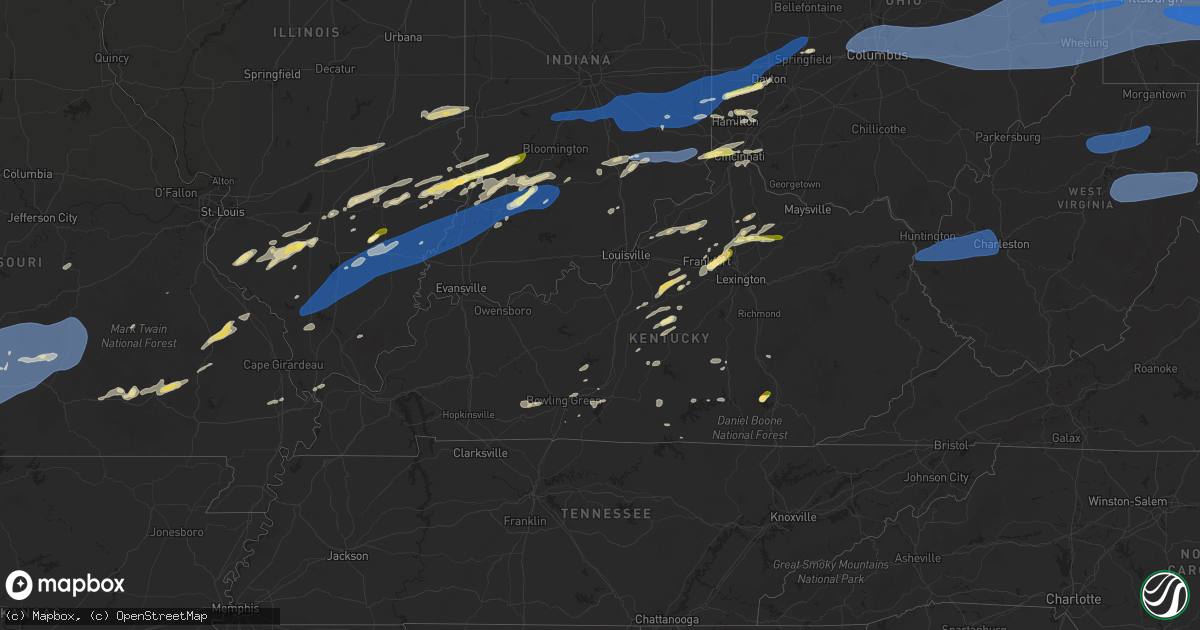
Hail Map in Kentucky on April 29, 2025
Get this storm
April 29 map
$229
one time, instant access
Download today. No call, no setup
Keep the $229
Bought the map and want the full workflow? Apply the entire $229 to a subscription within 7 days. None of it is wasted.
Every map, not just this one
This buys you this map. Subscription and you get every map we run, in the markets you choose from a few cities to whole states to nationwide. Plus real-time alerts the moment a storm fires.
Contact data
Name, contact info, occupancy, even credit band for addresses in the footprint. You go from where it hit to who to call.
Become the source they trust
Unlimited branding weather history reports on demand. You already have the documented answer ready for the property owner, and you are the one who showed up with it.
Property data and RoofTrace estimates
Pull up any address you have got, its value and the exact code rules for that jurisdiction, straight from One Click Code. Then RoofTrace estimates the squares, pitch, and roof value, priced the way you price.
Storm reports in Kentucky
Kentucky
| Date | Description |
|---|---|
| 04/29/20256:53 PM CDT | Report of trees down. |
| 04/29/20256:51 PM CDT | Report of tree down. |
| 04/29/20256:48 PM CDT | Tree down on the road. |
| 04/29/20256:41 PM CDT | Trees and powerlines were reported to have been blown down in the preston community. The event time is radar estimated. |
| 04/29/20256:38 PM CDT | Trees and powerlines were reported to have been blown down in more than one location along shrout road area in the kendall springs community. The event time is radar es |
| 04/29/20256:33 PM CDT | Montgomery county dispatch reports widespread tree damage across the county from the storms this evening. Point placed at a time and place where radar velocity returns |
| 04/29/20256:31 PM CDT | Trees were reported to have been blown down and a fence damaged at a residence along oldham road in the vicinity of camargo heights. The event time and location are bot |
| 04/29/20256:28 PM CDT | Resending previous tstm wnd dmg report from 1 ssw ewington due to iris error message. Montgomery county dispatch reports downed trees blocking osborne road from the thu |
| 04/29/20256:27 PM CDT | Montgomery county dispatch reports widespread tree damage across the county from the storms this evening. Point placed at a time and place where radar velocity returns |
| 04/29/20256:18 PM CDT | Large tree uprooted in independence. Time estimated by radar. |
| 04/29/20256:17 PM CDT | Multiple trees reported down around winchester... Ky. |
| 04/29/20256:16 PM CDT | Large tree downed along independence station road. Time estimated by radar. |
| 04/29/20256:13 PM CDT | Large tree downed over wooden fencing. |
| 04/29/20256:12 PM CDT | Two trees down on stoney point rd. Time estimated from radar. |
| 04/29/20255:12 PM CDT | Twitter report shows picture of quarter size hail. |
| 04/29/20255:09 PM CDT | Large tree down across cisselville rd near loretto rd intersection. |
| 04/29/20254:56 PM CDT | Report from mping: quarter |
| 04/28/20258:25 PM CDT | Social media report of a small tree down on a barn near the end of freeman fork road in extreme sw breathitt county. Time estimated via radar. |
| 04/28/20258:22 PM CDT | Wayne county 911 reports trees downed on dugan street in monticello. Time estimated via radar. |
| 04/28/20258:10 PM CDT | Social media report of a tree down near the old vincent post office... Time estimated via radar. |
| 04/28/20258:09 PM CDT | A tree was reported to have been downed and blocking down and around road off of ky 30 and also south of exit 70 along the mountain parkway. The event time is radar est |
| 04/28/20257:52 PM CDT | 2- to 3-inch diameter tree branch blocking the northbound lane of ky highway 1812 approximately one-half mile north of the breathitt county line. Time estimated from ra |
| 04/28/20257:47 PM CDT | Social media report of a tree down on privett lane in the wolverine area of breathitt count. Time estimated via radar. |
| 04/28/20257:44 PM CDT | Jackson county 911 center reported a tree down near the 580 block of brushy ridge rd. Time estimate from radar. |
| 04/28/20257:30 PM CDT | Tree down on us 127 blocking part of the hwy near the casey county board of education. |
| 04/28/20257:17 PM CDT | Picture of power lines downed by a fallen tree in the south irvine community. Time estimated via radar. |
| 04/28/20257:02 PM CDT | Trees and powerlines were reported to have been blown down at the intersection of brown street and pettit avenue. The event time is radar estimated. |
| 04/28/20257:00 PM CDT | Trees and powerlines were reported to have been blown down at 308 clearfield hill road. The event time is radar estimated. |
| 04/28/20257:00 PM CDT | Trees and powerlines were reported to have been blown down at 926 old flemingsburg rd.... Morehead. The event time is radar estimated. |
All States Impacted by Hail Map on April 29, 2025
Cities Impacted by Hail Map on April 29, 2025
- McCune, KS
- Cherokee, KS
- Delaware, OK
- Coffeyville, KS
- Nowata, OK
- Lenapah, OK
- Red Bud, IL
- S Coffeyville, OK
- Baldwin, IL
- Collinsville, OK
- Ramona, OK
- Vera, OK
- Ochelata, OK
- Skiatook, OK
- Pittsburg, KS
- Sperry, OK
- Owasso, OK
- Tulsa, OK
- Claremore, OK
- Oswego, KS
- Edna, KS
- Bartlett, KS
- Girard, KS
- Vinita, OK
- Talala, OK
- Oologah, OK
- Marissa, IL
- Coulterville, IL
- Westfield, IL
- Ashmore, IL
- Casey, IL
- New Athens, IL
- Lenzburg, IL
- Weir, KS
- Welch, OK
- Chelsea, OK
- Tilden, IL
- Sparta, IL
- Adair, OK
- Pryor, OK
- Big Cabin, OK
- Chetopa, KS
- Scammon, KS
- Oakdale, IL
- Nashville, IL
- Martinsville, IL
- Marshall, IL
- Kansas, IL
- Paris, IL
- Frontenac, KS
- Mindenmines, MO
- Columbus, KS
- Ramsey, IL
- Vandalia, IL
- Addieville, IL
- Strang, OK
- Spavinaw, OK
- Brownstown, IL
- Beecher City, IL
- Saint Elmo, IL
- Dennison, IL
- Riverton, KS
- Galena, KS
- Joplin, MO
- Miami, OK
- North Miami, OK
- Commerce, OK
- Carl Junction, MO
- Asbury, MO
- Afton, OK
- Ketchum, OK
- Eucha, OK
- Jay, OK
- Grove, OK
- Wyandotte, OK
- Webb City, MO
- Oronogo, MO
- Altamont, IL
- Odin, IL
- Baxter Springs, KS
- West Terre Haute, IN
- Salem, IL
- Fairland, OK
- Sheldon, MO
- Lamar, MO
- Effingham, IL
- Shumway, IL
- Carterville, MO
- Carthage, MO
- Diamond, MO
- Duenweg, MO
- Purcell, MO
- Jasper, MO
- Neck City, MO
- Alba, MO
- Gravette, AR
- South West City, MO
- Anderson, MO
- Noel, MO
- Tiff City, MO
- Goodman, MO
- Seneca, MO
- Neosho, MO
- Pineville, MO
- Lanagan, MO
- Texico, IL
- Bluford, IL
- Kinmundy, IL
- Iuka, IL
- Xenia, IL
- Louisville, IL
- Kell, IL
- Teutopolis, IL
- Granby, MO
- Stella, MO
- Powell, MO
- Rocky Comfort, MO
- Stark City, MO
- Wheaton, MO
- Exeter, MO
- Fairview, MO
- Purdy, MO
- Pierce City, MO
- Wentworth, MO
- Reeds, MO
- Avilla, MO
- Sigel, IL
- La Russell, MO
- Sarcoxie, MO
- Golden City, MO
- Monett, MO
- Stotts City, MO
- Butterfield, MO
- Cassville, MO
- Miller, MO
- Lockwood, MO
- Verona, MO
- Mount Vernon, MO
- Freistatt, MO
- Aurora, MO
- Crane, MO
- Claremont, IL
- Dundas, IL
- Newton, IL
- Ingraham, IL
- South Greenfield, MO
- Marionville, MO
- Galena, MO
- Billings, MO
- Ash Grove, MO
- Nixa, MO
- Clever, MO
- Bois D Arc, MO
- Republic, MO
- Halltown, MO
- Everton, MO
- Inola, OK
- Chouteau, OK
- Locust Grove, OK
- Salina, OK
- Rose, OK
- Colcord, OK
- Kansas, OK
- Gentry, AR
- Maysville, AR
- Bentonville, AR
- Decatur, AR
- Rogers, AR
- Centerton, AR
- Pea Ridge, AR
- Hiwasse, AR
- Sulphur Springs, AR
- Seligman, MO
- Bella Vista, AR
- Washburn, MO
- Bridgeport, IL
- Flat Rock, IL
- Sumner, IL
- West Liberty, IL
- Willard, MO
- Brookline, MO
- Ozark, MO
- Walnut Grove, MO
- Springfield, MO
- Rogersville, MO
- Fair Grove, MO
- Oblong, IL
- Robinson, IL
- Oaktown, IN
- Palestine, IL
- Willow Hill, IL
- Lawrenceville, IL
- Carlisle, IN
- Highlandville, MO
- Cape Fair, MO
- Ponce De Leon, MO
- Reeds Spring, MO
- Spokane, MO
- Chestnutridge, MO
- Walnut Shade, MO
- Forsyth, MO
- Garrison, MO
- Oldfield, MO
- Sparta, MO
- Taneyville, MO
- Chadwick, MO
- Strafford, MO
- Marshfield, MO
- Fordland, MO
- Bruner, MO
- Pleasant Hope, MO
- Linton, IN
- Merom, IN
- Sullivan, IN
- Brighton, MO
- Elkland, MO
- Buffalo, MO
- Conway, MO
- Seymour, MO
- Niangua, MO
- Ava, MO
- Bradleyville, MO
- Mansfield, MO
- Squires, MO
- Bolivar, MO
- Lyons, IN
- Switz City, IN
- Worthington, IN
- Bloomfield, IN
- Dugger, IN
- Sandborn, IN
- Norwood, MO
- Grovespring, MO
- Phillipsburg, MO
- Macomb, MO
- Hartville, MO
- Lebanon, MO
- Louisburg, MO
- Half Way, MO
- Allen, OK
- Drury, MO
- Mountain Grove, MO
- Falcon, MO
- Lynchburg, MO
- Atwood, OK
- Laquey, MO
- Graff, MO
- Paragon, IN
- Martinsville, IN
- Morgantown, IN
- Trafalgar, IN
- Franklin, IN
- Bargersville, IN
- Plato, MO
- Huggins, MO
- Cabool, MO
- Houston, MO
- Bucyrus, MO
- Success, MO
- Roby, MO
- Licking, MO
- Waynesville, MO
- Duke, MO
- Fort Leonard Wood, MO
- Edinburgh, IN
- Needham, IN
- Shelbyville, IN
- Boggstown, IN
- Vichy, MO
- Vienna, MO
- Solo, MO
- Yukon, MO
- Raymondville, MO
- Eunice, MO
- Hartshorn, MO
- Fairland, IN
- Manilla, IN
- Morristown, IN
- Arlington, IN
- Beulah, MO
- Edgar Springs, MO
- Newburg, MO
- Salem, MO
- Lenox, MO
- Homer, IN
- Rushville, IN
- Waldron, IN
- Milroy, IN
- Seymour, IN
- Columbus, IN
- Flat Rock, IN
- Rolla, MO
- Bluejacket, OK
- Glenwood, IN
- Quapaw, OK
- Picher, OK
- Treece, KS
- Connersville, IN
- Laurel, IN
- Greensburg, IN
- Scipio, IN
- North Vernon, IN
- Butlerville, IN
- Elizabethtown, IN
- Jonesville, IN
- Birch Tree, MO
- Metamora, IN
- Liberty, IN
- Brookville, IN
- Hope, IN
- Saint Paul, IN
- Batesville, IN
- Oldenburg, IN
- Holton, IN
- Versailles, IN
- Osgood, IN
- Westport, IN
- Winona, MO
- Eminence, MO
- Boss, MO
- Goshen, KY
- Milan, IN
- Cedar Grove, IN
- New Trenton, IN
- West Harrison, IN
- Brownsville, IN
- Centerville, IN
- Richmond, IN
- Eaton, OH
- Boston, IN
- Camden, OH
- West College Corner, IN
- College Corner, OH
- Oxford, OH
- Bath, IN
- Hamilton, OH
- Okeana, OH
- Vian, OK
- La Grange, KY
- Crestwood, KY
- Van Buren, MO
- Bunch, OK
- Sallisaw, OK
- Somerville, OH
- West Alexandria, OH
- Lewisburg, OH
- Dillsboro, IN
- Moores Hill, IN
- Guilford, IN
- Aurora, IN
- Sunman, IN
- Piedmont, MO
- Ellington, MO
- Stilwell, OK
- Ellsinore, MO
- Brookville, OH
- Germantown, OH
- New Lebanon, OH
- Farmersville, OH
- Fredericktown, MO
- Mill Spring, MO
- Cleves, OH
- Cincinnati, OH
- Perryville, MO
- Patton, MO
- Patterson, MO
- Fort Stockton, TX
- Potosi, MO
- Dayton, OH
- Vandalia, OH
- Clayton, OH
- Englewood, OH
- Tipp City, OH
- Troy, OH
- New Carlisle, OH
- Medway, OH
- Springfield, OH
- Urbana, OH
- Tremont City, OH
- North Hampton, OH
- Saint Paris, OH
- West Milton, OH
- Imperial, TX
- Silva, MO
- North Bend, OH
- Greenville, MO
- Plain City, OH
- West Jefferson, OH
- Amlin, OH
- Dublin, OH
- Delaware, OH
- Powell, OH
- Hilliard, OH
- Lewis Center, OH
- Westerville, OH
- Columbus, OH
- Galloway, OH
- Galena, OH
- New Albany, OH
- Sunbury, OH
- Johnstown, OH
- Pleasureville, KY
- Bethlehem, KY
- New Castle, KY
- Smithfield, KY
- Sulphur, KY
- Pendleton, KY
- Ashley, IL
- Okawville, IL
- Eminence, KY
- Richview, IL
- Sims, IL
- Geff, IL
- Meadow, TX
- Ropesville, TX
- Wayne City, IL
- Vergennes, IL
- Campbellsburg, KY
- Keenes, IL
- Owenton, KY
- Lockport, KY
- Flora, IL
- Odonnell, TX
- Tahoka, TX
- Clay City, IL
- Noble, IL
- Perry Park, KY
- Turners Station, KY
- Cisne, IL
- Crane, TX
- Wolfforth, TX
- Lubbock, TX
- Attica, NY
- Warsaw, NY
- Olney, IL
- Varysburg, NY
- Anna, IL
- Makanda, IL
- Carbondale, IL
- Cobden, IL
- Johnsonville, IL
- Dale, NY
- Wyoming, NY
- Pavilion, NY
- Piffard, NY
- Centralia, IL
- East China, MI
- Marine City, MI
- Cannelburg, IN
- Montgomery, IN
- Strykersville, NY
- Vincennes, IN
- Pinckneyville, IL
- Hoyleton, IL
- Georgetown, KY
- Sadieville, KY
- Woodlawn, IL
- Bicknell, IN
- Ragsdale, IN
- Sikeston, MO
- Loogootee, IN
- York, NY
- Avon, NY
- Caledonia, NY
- Linwood, NY
- Ewing, IL
- Belle Rive, IL
- Ina, IL
- Elnora, IN
- Plainville, IN
- Washington, IN
- Edwardsport, IN
- Post, TX
- Crane, IN
- Cynthiana, KY
- Reynoldsburg, OH
- Millersport, OH
- Etna, OH
- Baltimore, OH
- Blacklick, OH
- Pataskala, OH
- Hebron, OH
- Heath, OH
- Kirkersville, OH
- Zanesville, OH
- Granville, OH
- Hopewell, OH
- Mount Perry, OH
- Glenford, OH
- Jacksontown, OH
- Alexandria, OH
- Buckeye Lake, OH
- Thornville, OH
- Nashport, OH
- Norwich, OH
- New Concord, OH
- Chandlersville, OH
- Newark, OH
- Frazeysburg, OH
- Saint Louisville, OH
- Adamsville, OH
- Dresden, OH
- Trinway, OH
- Cambridge, OH
- Kipling, OH
- Lore City, OH
- Byesville, OH
- Cumberland, OH
- Pleasant City, OH
- Quaker City, OH
- Salesville, OH
- Old Washington, OH
- Senecaville, OH
- Kimbolton, OH
- Java Village, NY
- North Java, NY
- Holland, NY
- Jerusalem, OH
- Barnesville, OH
- Piedmont, OH
- Freeport, OH
- Flushing, OH
- Cadiz, OH
- Bethesda, OH
- Port Washington, OH
- Smithfield, OH
- Saint Clairsville, OH
- Mingo Junction, OH
- Steubenville, OH
- Morristown, OH
- Dillonvale, OH
- Adena, OH
- Rayland, OH
- Belmont, OH
- Bloomingdale, OH
- Yorkville, OH
- Neffs, OH
- Alledonia, OH
- Glen Dale, WV
- Bridgeport, OH
- Bellaire, OH
- Moundsville, WV
- Wheeling, WV
- Windsor Heights, WV
- Brilliant, OH
- Shadyside, OH
- Beallsville, OH
- Wellsburg, WV
- Jacobsburg, OH
- Powhatan Point, OH
- Beech Bottom, WV
- Martins Ferry, OH
- Glen Easton, WV
- Mcmechen, WV
- Benwood, WV
- Mount Pleasant, OH
- Tiltonsville, OH
- Duncan Falls, OH
- Hopedale, OH
- Tippecanoe, OH
- Scio, OH
- Jewett, OH
- Richmond, OH
- Hammondsville, OH
- Amsterdam, OH
- Bergholz, OH
- Toronto, OH
- Irondale, OH
- Newell, WV
- New Cumberland, WV
- East Springfield, OH
- Wellsville, OH
- Leesville, OH
- Carrollton, OH
- Dennison, OH
- Bowerston, OH
- Midvale, OH
- Gnadenhutten, OH
- Uhrichsville, OH
- Tuscarawas, OH
- Salineville, OH
- New Philadelphia, OH
- Newcomerstown, OH
- Sherrodsville, OH
- Coshocton, OH
- Walhonding, OH
- Utica, OH
- Blissfield, OH
- Warsaw, OH
- Stone Creek, OH
- Fresno, OH
- Conesville, OH
- Plainfield, OH
- West Lafayette, OH
- Idalou, TX
- Blue Rock, OH
- White Cottage, OH
- Philo, OH
- Roseville, OH
- Sarahsville, OH
- Lewisville, OH
- Summerfield, OH
- Woodsfield, OH
- Caldwell, OH
- Cameron, WV
- Proctor, WV
- Asher, OK
- Konawa, OK
- Perry, NY
- Gail, TX
- Jayton, TX
- Aspermont, TX
- Follansbee, WV
- Colliers, WV
- Burgettstown, PA
- Weirton, WV
- Chester, WV
- Stratton, OH
- New Manchester, WV
- Hookstown, PA
- Midland, PA
- Georgetown, PA
- Empire, OH
- South Heights, PA
- Aliquippa, PA
- West Alexander, PA
- Monaca, PA
- Baden, PA
- West Liberty, WV
- Shippingport, PA
- Langeloth, PA
- Claysville, PA
- Avella, PA
- Clinton, PA
- Imperial, PA
- Valley Grove, WV
- Crescent, PA
- Industry, PA
- Dallas, WV
- Bethany, WV
- Sewickley, PA
- Bulger, PA
- Ambridge, PA
- Atlasburg, PA
- Triadelphia, WV
- Leetsdale, PA
- Joffre, PA
- Coraopolis, PA
- Slovan, PA
- Strabane, PA
- Meadow Lands, PA
- Eighty Four, PA
- Southview, PA
- Oakdale, PA
- McDonald, PA
- Canonsburg, PA
- Washington, PA
- West Finley, PA
- Hickory, PA
- Muse, PA
- Cuddy, PA
- Midway, PA
- Sturgeon, PA
- Westland, PA
- Amity, PA
- Houston, PA
- Pittsburgh, PA
- Cecil, PA
- Prosperity, PA
- Carlisle, KY
- Lorenzo, TX
- Leicester, NY
- Mount Morris, NY
- Dahlgren, IL
- Heltonville, IN
- Bedford, IN
- Newberry, IN
- Williams, IN
- Mound City, IL
- McCamey, TX
- Ozona, TX
- Odon, IN
- Calhoun, IL
- Colden, NY
- Stamping Ground, KY
- Victor, NY
- Bloomfield, NY
- Honeoye Falls, NY
- Lima, NY
- Clifton Springs, NY
- Canandaigua, NY
- Farmington, NY
- Manchester, NY
- Shortsville, NY
- Shoals, IN
- Macomb, OK
- Barnhill, IL
- Fairfield, IL
- Boston, NY
- Springville, NY
- Ozark, IL
- Stonefort, IL
- Barlow, KY
- Arcade, NY
- South Wales, NY
- Gainesville, NY
- Tecumseh, OK
- Ionia, NY
- Byars, OK
- Ada, OK
- Freelandville, IN
- Scotland, IN
- Bruceville, IN
- Westphalia, IN
- East Aurora, NY
- Eden, NY
- West Bloomfield, NY
- Cowlesville, NY
- Maud, OK
- Iraan, TX
- Lenorah, TX
- Retsof, NY
- Lamesa, TX
- Geneseo, NY
- Livonia, NY
- Lakeville, NY
- Phelps, NY
- Waterloo, NY
- Geneva, NY
- Lyons, NY
- Clyde, NY
- Seneca Falls, NY
- Weedsport, NY
- Port Byron, NY
- Montezuma, NY
- Savannah, NY
- Cayuga, NY
- Ovid, NY
- Aurora, NY
- Palmyra, NY
- Fairview, OK
- North Collins, NY
- Justiceburg, TX
- Owensburg, IN
- Springville, IN
- Dryden, TX
- Newark, NY
- Silver Springs, NY
- Java Center, NY
- Otwell, IN
- Petersburg, IN
- Shelbyville, KY
- Glenwood, NY
- Lawtons, NY
- King Ferry, NY
- Scipio Center, NY
- Nineveh, PA
- Sycamore, PA
- Bridgeville, PA
- Marianna, PA
- Scenery Hill, PA
- Graysville, PA
- Morgan, PA
- Waynesburg, PA
- Venetia, PA
- Presto, PA
- Lawrence, PA
- Fredericktown, PA
- Clarksville, PA
- Carnegie, PA
- Cokeburg, PA
- McKees Rocks, PA
- De Soto, IL
- Murphysboro, IL
- Ackerly, TX
- Cambria, IL
- Carterville, IL
- Hurst, IL
- Grand Tower, IL
- Energy, IL
- Herrin, IL
- Benton, IL
- Johnston City, IL
- Freeman Spur, IL
- Royalton, IL
- Zeigler, IL
- Mulkeytown, IL
- Orient, IL
- West Frankfort, IL
- Buckner, IL
- Elkville, IL
- Christopher, IL
- Sesser, IL
- Whittington, IL
- Macedonia, IL
- Bonnie, IL
- Thompsonville, IL
- Logan, IL
- McLeansboro, IL
- Springerton, IL
- Enfield, IL
- Mill Shoals, IL
- Burnt Prairie, IL
- Carmi, IL
- Albion, IL
- Golden Gate, IL
- Crossville, IL
- Grayville, IL
- Ellery, IL
- Griffin, IN
- Browns, IL
- Mount Carmel, IL
- Owensville, IN
- West Salem, IL
- Bellmont, IL
- Bone Gap, IL
- Princeton, IN
- Hazleton, IN
- Monroe City, IN
- Patoka, IN
- Francisco, IN
- Saint Francisville, IL
- Allendale, IL
- Decker, IN
- Wheatland, IN
- Wewoka, OK
- Brownstown, IN
- Avoca, IN
- Snyder, TX
- Natrona Heights, PA
- Dravosburg, PA
- Glenshaw, PA
- Duquesne, PA
- Mars, PA
- Russellton, PA
- Sarver, PA
- Gibsonia, PA
- Saxonburg, PA
- Springdale, PA
- Oakmont, PA
- Valencia, PA
- Bentleyville, PA
- Coal Center, PA
- Creighton, PA
- Charleroi, PA
- South Park, PA
- Bunola, PA
- Harwick, PA
- Verona, PA
- Mckeesport, PA
- Finleyville, PA
- Freedom, PA
- Tarentum, PA
- Conway, PA
- Daisytown, PA
- Bairdford, PA
- Clairton, PA
- Braddock, PA
- New Eagle, PA
- Warrendale, PA
- Allison Park, PA
- Cranberry Township, PA
- Beallsville, PA
- Elrama, PA
- Indianola, PA
- Bethel Park, PA
- Wexford, PA
- Glassport, PA
- Van Voorhis, PA
- Ellsworth, PA
- West Mifflin, PA
- Cheswick, PA
- Bradfordwoods, PA
- New Kensington, PA
- Monongahela, PA
- Turtle Creek, PA
- Bakerstown, PA
- Homestead, PA
- Richeyville, PA
- Tarrs, PA
- Smithton, PA
- Darragh, PA
- Bovard, PA
- Claridge, PA
- Brackenridge, PA
- East Pittsburgh, PA
- Belle Vernon, PA
- Monessen, PA
- Stockdale, PA
- Buena Vista, PA
- Freeport, PA
- Rillton, PA
- Donora, PA
- Everson, PA
- Latrobe, PA
- Roscoe, PA
- Brownsville, PA
- Forbes Road, PA
- Scottdale, PA
- Yukon, PA
- Saltsburg, PA
- Jeannette, PA
- Hannastown, PA
- Penn, PA
- Larimer, PA
- Sutersville, PA
- California, PA
- Grindstone, PA
- Pleasant Unity, PA
- Vanderbilt, PA
- Wyano, PA
- Star Junction, PA
- Trafford, PA
- Slickville, PA
- Connellsville, PA
- New Stanton, PA
- Export, PA
- Elco, PA
- Pitcairn, PA
- Harrison City, PA
- Hunker, PA
- New Alexandria, PA
- Leechburg, PA
- Greenock, PA
- Dunlevy, PA
- Newell, PA
- Arona, PA
- Wickhaven, PA
- Alverton, PA
- Madison, PA
- Luxor, PA
- Wilmerding, PA
- Ligonier, PA
- Webster, PA
- Westmoreland City, PA
- Greensburg, PA
- Allenport, PA
- Hostetter, PA
- Lowber, PA
- West Newton, PA
- East McKeesport, PA
- Stahlstown, PA
- Adamsburg, PA
- Ardara, PA
- Fayette City, PA
- Acme, PA
- Youngwood, PA
- North Versailles, PA
- Irwin, PA
- Perryopolis, PA
- Dawson, PA
- Murrysville, PA
- Donegal, PA
- Mount Pleasant, PA
- West Elizabeth, PA
- Manor, PA
- Monroeville, PA
- Apollo, PA
- Grapeville, PA
- Crabtree, PA
- Herminie, PA
- Ruffs Dale, PA
- Delmont, PA
- Elizabeth, PA
- Baldwinsville, NY
- Warners, NY
- Liverpool, NY
- Clay, NY
- Phoenix, NY
- Ralls, TX
- Floydada, TX
- Syracuse, NY
- Cicero, NY
- Pennellville, NY
- Brewerton, NY
- East Syracuse, NY
- Sylvan Beach, NY
- Durhamville, NY
- Cleveland, NY
- Chittenango, NY
- Bridgeport, NY
- Canastota, NY
- Kirkville, NY
- Verona Beach, NY
- Jordan, NY
- Memphis, NY
- Dickens, TX
- Paducah, TX
- Camillus, NY
- Old Glory, TX
- Moravia, NY
- Auburn, NY
- Skaneateles, NY
- Marietta, NY
- Tully, NY
- Nedrow, NY
- La Fayette, NY
- Jamesville, NY
- Fayetteville, NY
- Minoa, NY
- Holdenville, OK
- Sasakwa, OK
- Bradenville, PA
- Youngstown, PA
- Aultman, PA
- Kittanning, PA
- Clune, PA
- Rural Valley, PA
- Marion Center, PA
- East Vandergrift, PA
- Elderton, PA
- Vandergrift, PA
- Lucernemines, PA
- Spring Church, PA
- Home, PA
- Loyalhanna, PA
- Indiana, PA
- Coral, PA
- Black Lick, PA
- Hyde Park, PA
- Derry, PA
- West Lebanon, PA
- Creekside, PA
- New Derry, PA
- Homer City, PA
- Ford City, PA
- Shelocta, PA
- North Apollo, PA
- Blairsville, PA
- Clarksburg, PA
- McIntyre, PA
- Avonmore, PA
- Josephine, PA
- Mitchell, IN
- West Baden Springs, IN
- Lawrenceburg, KY
- Bardstown, KY
- Taylorsville, KY
- Blossvale, NY
- West Monroe, NY
- Central Square, NY
- North Bay, NY
- Camden, NY
- Bernhards Bay, NY
- Constantia, NY
- Ford Cliff, PA
- Cadogan, PA
- Manorville, PA
- Sagamore, PA
- Butler, PA
- McGrann, PA
- Cabot, PA
- Worthington, PA
- New Brighton, PA
- Zelienople, PA
- Callery, PA
- Beaver, PA
- Rochester, PA
- Harmony, PA
- Fombell, PA
- Evans City, PA
- Renfrew, PA
- East Liverpool, OH
- Darlington, PA
- New Galilee, PA
- Koppel, PA
- Ellwood City, PA
- Beaver Falls, PA
- Wampum, PA
- Lisbon, OH
- Mechanicstown, OH
- Rogers, OH
- Negley, OH
- East Palestine, OH
- Connoquenessing, PA
- Summitville, OH
- Dellroy, OH
- Kensington, OH
- Mineral City, OH
- Hanoverton, OH
- London, KY
- Girard, TX
- Mount Eden, KY
- Coxs Creek, KY
- Bloomfield, KY
- Spur, TX
- Waddy, KY
- Boston, KY
- New Haven, KY
- Fairfield, KY
- Bowling Green, KY
- Orleans, IN
- Dilltown, PA
- Marsteller, PA
- Johnstown, PA
- Ernest, PA
- Ebensburg, PA
- Clymer, PA
- Robinson, PA
- Dixonville, PA
- Nicktown, PA
- Hastings, PA
- Brush Valley, PA
- Emeigh, PA
- Cherry Tree, PA
- Heilwood, PA
- Rector, PA
- Commodore, PA
- Spangler, PA
- New Florence, PA
- Twin Rocks, PA
- Mentcle, PA
- Northern Cambria, PA
- Alverda, PA
- Seward, PA
- Laughlintown, PA
- Boswell, PA
- Starford, PA
- Penn Run, PA
- Armagh, PA
- Strongstown, PA
- Vintondale, PA
- Belsano, PA
- Bolivar, PA
- Carrolltown, PA
- Stoystown, PA
- Champion, PA
- Nanty Glo, PA
- Friedens, PA
- Somerset, PA
- Acosta, PA
- White, PA
- Jennerstown, PA
- Jones Mills, PA
- Quecreek, PA
- Jenners, PA
- Hollsopple, PA
- Gray, PA
- Hernando, MS
- Chaplin, KY
- Frankfort, KY
- Springfield, KY
- Nesbit, MS
- Saint Francis, KY
- New Hope, KY
- Wetumka, OK
- Versailles, KY
- Loretto, KY
- Mount Sherman, KY
- Lebanon, KY
- Seven Mile, OH
- Rome, NY
- Verona, NY
- Taberg, NY
- Whitesboro, NY
- Vernon, NY
- Westmoreland, NY
- Clinton, NY
- Oriskany, NY
- Marcy, NY
- Holland Patent, NY
- Stittville, NY
- Lee Center, NY
- Ava, NY
- Forestport, NY
- Boonville, NY
- Westernville, NY
- Woodgate, NY
- Williamstown, NY
- Remsen, NY
- Utica, NY
- Barneveld, NY
- Poland, NY
- Alder Creek, NY
- Prospect, NY
- Midway, KY
- Dustin, OK
- Saint Catharine, KY
- Franklin, OH
- Middletown, OH
- Salem, IN
- Trenton, OH
- Buffalo, KY
- Willisburg, KY
- Southaven, MS
- Berry, KY
- Glen Campbell, PA
- Gipsy, PA
- Arcadia, PA
- Mahaffey, PA
- Rochester Mills, PA
- Hillsdale, PA
- Westover, PA
- La Jose, PA
- Grampian, PA
- Burnside, PA
- Rossiter, PA
- Templeton, PA
- Punxsutawney, PA
- Smicksburg, PA
- Adrian, PA
- Hamilton, PA
- Big Run, PA
- Fenelton, PA
- Cowansville, PA
- New Bethlehem, PA
- Walston, PA
- Northpoint, PA
- Dayton, PA
- Valier, PA
- Luthersburg, PA
- Yatesboro, PA
- Seymour, TX
- Somerset, KY
- Corbin, KY
- Keavy, KY
- Miamisburg, OH
- Emlenton, PA
- Knox, PA
- Monroe, OH
- Falmouth, KY
- Scottsburg, IN
- Mammoth Cave, KY
- Sweeden, KY
- Corinth, KY
- Weleetka, OK
- Little Falls, NY
- Newport, NY
- Cold Brook, NY
- Salisbury Center, NY
- Eufaula, OK
- Hanna, OK
- Stratford, NY
- Hoffmeister, NY
- Caroga Lake, NY
- Lamar, OK
- Piseco, NY
- Lake Pleasant, NY
- Hammondsport, NY
- Dundee, NY
- Bradford, NY
- Penn Yan, NY
- Branchport, NY
- Prattsburgh, NY
- Pulteney, NY
- Keuka Park, NY
- Himrod, NY
- Lodi, NY
- Interlaken, NY
- Hector, NY
- Salix, PA
- Mineral Point, PA
- New Enterprise, PA
- Colver, PA
- New Millport, PA
- Claysburg, PA
- Hopewell, PA
- Patton, PA
- Coalport, PA
- Portage, PA
- Parkhill, PA
- Windber, PA
- Hollidaysburg, PA
- Ashville, PA
- Woodbury, PA
- Cresson, PA
- New Paris, PA
- Sproul, PA
- Davidsville, PA
- Osterburg, PA
- Loysburg, PA
- Flinton, PA
- Loretto, PA
- Central City, PA
- Irvona, PA
- Seanor, PA
- South Fork, PA
- Lilly, PA
- Saint Benedict, PA
- Elmora, PA
- Schellsburg, PA
- Elton, PA
- Queen, PA
- East Freedom, PA
- Hooversville, PA
- Saxton, PA
- Bedford, PA
- Cairnbrook, PA
- Alum Bank, PA
- Fallentimber, PA
- Gallitzin, PA
- Chest Springs, PA
- Cassandra, PA
- Altoona, PA
- Jerome, PA
- Sidman, PA
- Wilmore, PA
- Imler, PA
- Martinsburg, PA
- Everett, PA
- Roaring Spring, PA
- Six Mile Run, PA
- Fishertown, PA
- Duncansville, PA
- Newry, PA
- Saint Michael, PA
- Summerhill, PA
- Beaverdale, PA
- Curwensville, PA
- Dysart, PA
- Saint Boniface, PA
- Williamsburg, PA
- Madera, PA
- Tyrone, PA
- James Creek, PA
- Glen Hope, PA
- Blandburg, PA
- Lebanon, OH
- Munson, PA
- Karthaus, PA
- Morrisdale, PA
- Tipton, PA
- Pennsylvania Furnace, PA
- Warriors Mark, PA
- Ramey, PA
- Osceola Mills, PA
- Smithmill, PA
- Bellwood, PA
- Allport, PA
- Frenchville, PA
- Clarence, PA
- Clearfield, PA
- Sandy Ridge, PA
- Wallaceton, PA
- Alexandria, PA
- Kylertown, PA
- Spruce Creek, PA
- Brisbin, PA
- Woodland, PA
- Beccaria, PA
- Hawk Run, PA
- Julian, PA
- West Decatur, PA
- Hesston, PA
- Moshannon, PA
- Philipsburg, PA
- Olanta, PA
- Houtzdale, PA
- Mineral Springs, PA
- Glen Richey, PA
- Entriken, PA
- Snow Shoe, PA
- Hyde, PA
- Lanse, PA
- Port Matilda, PA
- Grassflat, PA
- Bigler, PA
- Drifting, PA
- Winburne, PA
- Lockney, TX
- Midkiff, TX
- Lawrenceburg, IN
- Petersburg, KY
- Benjamin, TX
- Hebron, KY
- Clarksville, TN
- Russellville, KY
- Mason, OH
- Auburn, KY
- Lewisburg, KY
- Olive Branch, MS
- Addyston, OH
- Hennessey, OK
- Waukomis, OK
- Speculator, NY
- Wells, NY
- Trumansburg, NY
- Groton, NY
- Lansing, NY
- Locke, NY
- Genoa, NY
- Ithaca, NY
- Crowell, TX
- Freeville, NY
- Dryden, NY
- Douglas, OK
- Brownsville, KY
- Smiths Grove, KY
- O'Brien, TX
- Knox City, TX
- Henryetta, OK
- Mount Olivet, KY
- Oakland, KY
- Big Lake, TX
- Bison, OK
- Drummond, OK
- Osceola, PA
- Middlebury Center, PA
- Knoxville, PA
- Westfield, PA
- Wellsboro, PA
- Lawrenceville, PA
- Nelson, PA
- Millerton, PA
- Tioga, PA
- Mansfield, PA
- Loganton, PA
- Lock Haven, PA
- University Park, PA
- Mill Hall, PA
- Fleming, PA
- Huntingdon, PA
- Orviston, PA
- Beech Creek, PA
- Rebersburg, PA
- Petersburg, PA
- Howard, PA
- Lamar, PA
- Centre Hall, PA
- Boalsburg, PA
- Madisonburg, PA
- Blanchard, PA
- Pine Grove Mills, PA
- Lemont, PA
- Bellefonte, PA
- Milesburg, PA
- State College, PA
- Spring Mills, PA
- Jersey Shore, PA
- Burnham, PA
- Belleville, PA
- Todd, PA
- McClure, PA
- Cassville, PA
- Calvin, PA
- Orbisonia, PA
- Mifflintown, PA
- Avis, PA
- Mount Union, PA
- Yeagertown, PA
- East Waterford, PA
- Granville, PA
- McVeytown, PA
- Lewistown, PA
- Mill Creek, PA
- Milroy, PA
- Millmont, PA
- Mapleton Depot, PA
- Port Royal, PA
- Aaronsburg, PA
- Millheim, PA
- Reedsville, PA
- Mifflin, PA
- Woodward, PA
- Coburn, PA
- Allensville, PA
- Honey Grove, PA
- McAlisterville, PA
- Beaver Springs, PA
- Richfield, PA
- Beavertown, PA
- Laurelton, PA
- Munday, TX
- Rochester, TX
- Weinert, TX
- Latonia, KY
- Fairmont, OK
- Fargo, OK
- Greensburg, KY
- Ft Mitchell, KY
- Covington, KY
- Checotah, OK
- Olmstead, KY
- Gillett, PA
- Wellsburg, NY
- Pine City, NY
- Columbia Cross Roads, PA
- Trout Run, PA
- Linden, PA
- Allenwood, PA
- Williamsport, PA
- Cogan Station, PA
- Mifflinburg, PA
- Enid, OK
- Lewisburg, PA
- New Columbia, PA
- Middleburg, PA
- Goree, TX
- Terrace Park, OH
- Milford, OH
- Buffalo, OK
- Newport, KY
- Silver Grove, KY
- Fort Thomas, KY
- Campbellsville, KY
- Cedar Hill, TN
- Adams, TN
- Glasgow, KY
- Waverly, NY
- Chemung, NY
- Sayre, PA
- Elmira, NY
- Athens, PA
- Haskell, TX
- Milan, PA
- Montgomery, PA
- New Berlin, PA
- Montoursville, PA
- Muncy, PA
- Winfield, PA
- West Milton, PA
- Northumberland, PA
- Milton, PA
- McEwensville, PA
- Selinsgrove, PA
- Montandon, PA
- Watsontown, PA
- Shamokin Dam, PA
- White Deer, PA
- Throckmorton, TX
- Kings Mountain, KY
- Yosemite, KY
- Middleburg, KY
- Waynesburg, KY
- Nichols, NY
- Hughesville, PA
- Sunbury, PA
- Muncy Valley, PA
- Hillsgrove, PA
- Mildred, PA
- Unityville, PA
- Eagles Mere, PA
- Bloomsburg, PA
- Laporte, PA
- Dushore, PA
- Forksville, PA
- Lairdsville, PA
- Danville, PA
- Turbotville, PA
- Millville, PA
- Catawissa, PA
- Riverside, PA
- Orangeville, PA
- Benton, PA
- Paxinos, PA
- Elysburg, PA
- Park City, KY
- Hartshorne, OK
- Scottsville, KY
- Vernon, TX
- Berwick, PA
- Shickshinny, PA
- Stillwater, PA
- Hunlock Creek, PA
- Mehoopany, PA
- Lopez, PA
- Harveys Lake, PA
- Mifflinville, PA
- Huntington Mills, PA
- Tunkhannock, PA
- Dallas, PA
- Noxen, PA
- Sweet Valley, PA
- Shavertown, PA
- Nanticoke, PA
- Wapwallopen, PA
- Plymouth, PA
- Mountain Top, PA
- Wilkes Barre, PA
- Glen Lyon, PA
- Nescopeck, PA
- Drums, PA
- Sugarloaf, PA
- Dalmatia, PA
- Herndon, PA
- Mount Pleasant Mills, PA
- Freeburg, PA
- Shamokin, PA
- Dornsife, PA
- Port Trevorton, PA
- Cocolamus, PA
- Liverpool, PA
- Oakland Mills, PA
- Thompsontown, PA
- Millerstown, PA
- Leck Kill, PA
- Ashland, PA
- Klingerstown, PA
- Wilburton, PA
- Marion Heights, PA
- Hazleton, PA
- Zion Grove, PA
- Trevorton, PA
- Shenandoah, PA
- Coal Township, PA
- Mount Carmel, PA
- Ringtown, PA
- Locust Gap, PA
- Sheppton, PA
- Rebuck, PA
- Kulpmont, PA
- Conyngham, PA
- Pitman, PA
- Nuremberg, PA
- Rock Glen, PA
- Clarks Summit, PA
- Factoryville, PA
- Harleigh, PA
- Nicholson, PA
- Pittston, PA
- Falls, PA
- Luzerne, PA
- Wyoming, PA
- Dalton, PA
- Kingston, PA
- Weatherly, PA
- Moosic, PA
- Freeland, PA
- Bear Creek, PA
- Moscow, PA
- Taylor, PA
- White Haven, PA
- Blakeslee, PA
- Gouldsboro, PA
- Beaver Meadows, PA
- Lake Harmony, PA
- Old Forge, PA
- Duryea, PA
- Scranton, PA
- Jamestown, KY
- Mcalester, OK
- Haileyville, OK
- Chillicothe, TX
- Columbia, KY
- Breeding, KY
- Rankin, TX
- Holliday, TX
- Olney, TX
- Stillwater, OK
- Coyle, OK
- Russell Springs, KY
- Orlando, KY
- Mount Vernon, KY
- Burkesville, KY
- Beaver, OK
- Bliss, NY
- Eubank, KY
- Rule, TX
- Newcastle, TX
- Electra, TX
- Iowa Park, TX
- Livingston, KY
- Mount Gilead, OH
- Bellville, OH
- Forgan, OK
- Perkins, OK
- Carney, OK
- Tryon, OK
- Windthorst, TX
- Wichita Falls, TX
- Archer City, TX
- Nancy, KY
- Wayne, WV
- Prichard, WV
- Lavalette, WV
- Huntington, WV
- Barboursville, WV
- East Lynn, WV
- Culloden, WV
- Branchland, WV
- Salt Rock, WV
- Milton, WV
- West Hamlin, WV
- Hamlin, WV
- Hurricane, WV
- Yawkey, WV
- Myra, WV
- Sod, WV
- Griffithsville, WV
- Scotland, TX
- Henrietta, TX
- Devol, OK
- Burkburnett, TX
- Walters, OK
- Randlett, OK
- Sheppard Afb, TX
- Grandfield, OK
- Bronston, KY
- Monticello, KY
- Ripley, OK
- Agra, OK
- Cushing, OK
- Mertzon, TX
- Barnhart, TX
- Saint Albans, WV
- Poca, WV
- Tornado, WV
- Winfield, WV
- Nitro, WV
- Scott Depot, WV
- Alum Creek, WV
- Charleston, WV
- Sumerco, WV
- South Charleston, WV
- Jacksboro, TX
- Loving, TX
- Petrolia, TX
- Dunbar, WV
- Albany, KY
- Anadarko, OK
- Belle, WV
- Temple, OK
- Byers, TX
- Geronimo, OK
- Bowie, TX
- Bellevue, TX
- Nocona, TX
- Waurika, OK
- Ryan, OK
- Hastings, OK
- Ringgold, TX
- Terral, OK
- Elkview, WV
- Gandeeville, WV
- Walton, WV
- Tad, WV
- Comanche, OK
- Duncan, OK
- Lawton, OK
- Rush, NY
- Mendon, NY
- Montague, TX
- Texarkana, TX
- Marlow, OK
- Lueders, TX
- Abilene, TX
- Stamford, TX
- Ashdown, AR
- Albany, TX
- Saint Jo, TX
- Ratliff City, OK
- Graham, OK
- Leon, OK
- Muenster, TX
- Burneyville, OK
- Wilson, OK
- Pickens, WV
- Mabie, WV
- Helvetia, WV
- French Creek, WV
- Tallmansville, WV
- Buckhannon, WV
- Mill Creek, WV
- Ellamore, WV
- Kanawha Head, WV
- Rock Cave, WV
- Crawford, WV
- Garden City, TX
- Ireland, WV
- Adrian, WV
- Cleveland, WV
- Selbyville, WV
- Beverly, WV
- Coalton, WV
- Valley Bend, WV
- Elkins, WV
- Glady, WV
- Whitmer, WV
- Norton, WV
- Harman, WV
- Seneca Rocks, WV
- Belington, WV
- Dryfork, WV
- Bowden, WV
- Clarksburg, WV
- West Milford, WV
- Lost Creek, WV
- New Milton, WV
- Salem, WV
- Mount Clare, WV
- Jane Lew, WV
- Camden, WV
- Weston, WV
- Bridgeport, WV
- Grafton, WV
- Flemington, WV
- Anmoore, WV
- Philippi, WV
- Overbrook, OK
- Big Spring, TX
- Loraine, TX
- Hobbs, NM
- Gainesville, TX
- Marietta, OK
- Westbrook, TX
- Colorado City, TX
- Barnsdall, OK
- Bartlesville, OK
- Dewey, OK
- Wann, OK
- Quanah, TX
- Seminole, TX
- Hollis, OK
- Roscoe, TX
- Sweetwater, TX
- Mclean, TX
- Seagraves, TX
- Gould, OK
- Harrold, TX
- Andrews, TX
- Coahoma, TX
- Frederick, OK
- Loveland, OK
- Rattan, OK
- Trent, TX
- Davidson, OK
- Brownfield, TX
- Hollister, OK
- Merkel, TX
- Valliant, OK
- Loop, TX
- Welch, TX
- Ira, TX
- Thackerville, OK
- Wilson, TX
- Hawley, TX
- Anson, TX
- Hermleigh, TX
- Hulbert, OK
- Tahlequah, OK
- Proctor, OK
- Westville, OK
- Tarzan, TX
- Dodson, TX
- Sheffield, TX
- Stanton, TX
- Rotan, TX
- Slaton, TX
- Oklaunion, TX
- Waldron, AR
- Crosbyton, TX
- Chattanooga, OK
- Knott, TX
- Monument, NM
- Faxon, OK
- Fluvanna, TX
- Denver City, TX
- Plains, TX
- Roby, TX
- McCaulley, TX
- Sylvester, TX
- Hamlin, TX
- Tussy, OK
- Elmore City, OK
- Foster, OK
- Tipton, OK
- Elmer, OK
- Indiahoma, OK
- Fremont, MO
- Liberty, KY
- Avoca, TX
- Cache, OK
- Woodson, TX


